26
0Activity Feed

**Updated SummitX**: changes include editing username, image upload, title indicator, and improved object sorting.
SummitX has been updated. This article describes the changes that have taken place over the past three days.
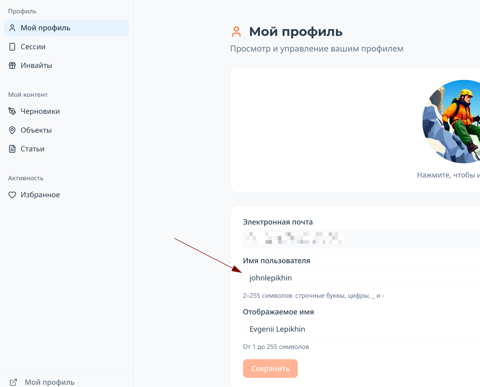
Editing username
In your personal account (for the Russian localization of the site, this is https://summitx.info/ru/account/profile), you can now change the strange username issued to you upon registration to something beautiful and familiar:
List of your articles in your personal account
Take a look at the image above: a section "My content → Articles" has appeared in your personal account. It will display all the articles you have ever written on the site.
Uploading images to articles and comments
Now, when inserting an image, the image upload process is displayed:
 This allows you to understand what is happening with the image and know when it will be fully uploaded.
Header indicator
Accidents on Hiking Trips. Part 2. Groups.
 ЛФЛеопард Фил
Risk analysis in alpinism and tourism depending on the type of group and its goals, considering risk generation factors and event consequences.
 In the second part about accidents, we dissect different groups by their route passage characteristics, resources, and ultimately by how they generate risks.
In the previous chapter, we found that the generated risks have the greatest impact on the events occurring within a group. However, different groups generate risks differently, even when the same participants in different teams can create risks in completely opposite ways.
Since we consider groups as a whole, as a single entity - simply because a group struggles with events as a unified organism - we will examine resources and risk generation primarily in relation to groups. Nevertheless, at certain stages, which we will inevitably explore using the example of ambitious participants and risk-loving participants, we will see that individual risk generation has a significant factor, especially if it involves: a) clients of commercial groups; b) group leaders.
Let's first define the division of groups based on the outcome of the route passage.
In the second part about accidents, we dissect different groups by their route passage characteristics, resources, and ultimately by how they generate risks.
In the previous chapter, we found that the generated risks have the greatest impact on the events occurring within a group. However, different groups generate risks differently, even when the same participants in different teams can create risks in completely opposite ways.
Since we consider groups as a whole, as a single entity - simply because a group struggles with events as a unified organism - we will examine resources and risk generation primarily in relation to groups. Nevertheless, at certain stages, which we will inevitably explore using the example of ambitious participants and risk-loving participants, we will see that individual risk generation has a significant factor, especially if it involves: a) clients of commercial groups; b) group leaders.
Let's first define the division of groups based on the outcome of the route passage.
Groups by Route Passage Outcome
Regarding the route outcome, regardless of its complexity, groups are divided into: a) those that have completed the route; b) those that have dropped out of the route without an accident; c) those that have dropped out of the route with an accident. We do not consider exceptional cases that confirm the rules. This is a very logical but "childish" division, which, however, is necessary for us to intermediate the connection between groups and risks, both inherent and generated. So, why did the first group complete the route? Because:
39
1Pavlenko's Video Guide: Shvab Route 5A on Baychechekhey
 ELEvgenii Lepikhin
Video guide to the Schwab route (5A) on Peak Baychechekhey by experienced mountaineer Dima Pavlenko.
Video guide for the Schwab route (5A, rock) on Peak Baychechekhey by Dima Pavlenko.
Loading video...
28
0Accidents on Hiking Trips. Part 1. Risks and Events.
ЛФЛеопард ФилThe article examines risks in alpinism and tourism, their classification into inherent and generated risks, and suggests methods for mitigating the negative impact of these risks on a group.
Types of Risks and Their Characteristics
For each type of human activity, a specific definition of risk can be derived. This definition also depends on the angle from which the risk is studied. In our case, for alpinism and tourism, the risks we will consider represent a condition that, if it occurs, has the potential to negatively impact the group. The difference here from more "classical" schemes is that we do not consider theoretical models but rather rely on practical ones. Thus, we take as an axiom that conditions capable of having a negative impact arise inevitably and on a constant basis. Firstly, many of them we create consciously and purposefully by setting certain frameworks and rules for navigating the route. Secondly, we are not capable of excluding all negative conditions because some of them arise independently of us. Thirdly, we almost never consider risks as conditions that can also have a positive impact on the group, as our research starts from accident rates rather than from accident-free conditions. In simple terms, our risks are "before something happens." When we work with risks as uncertain conditions, the event has not yet occurred. It is potential and will happen only with a certain degree of probability, high or low. Nevertheless, since we are considering the scheme of risks from a practical perspective, the probability itself in a mathematical sense is not of interest to us because it is not important. We suffer equally from an event that occurred with a "probability of 100%" and one with a "probability of 1%," if the impact of these events is the same. So, below we will structurally examine the risks that represent uncertain conditions capable of having a negative impact.
75
2
The article describes logistics, infrastructure, and seasonality for climbers in Kyrgyzstan's national parks, including information on transportation, accommodation, food, and weather conditions.
Logistics
How to Get There
By Private Vehicle
As of May 2025, entry to the national park is closed to vehicles with internal combustion engines. Entry for electric vehicles remains open and costs 800 som. There is a parking lot at the top, costing 50 som for an unlimited time.
By Taxi
You need to get to the entrance to the national park: https://www.openstreetmap.org/#map=19/42.655741/74.495202&layers=P. However, taxi drivers are not very fond of going there, so some minor difficulties may arise. The cost per car is around 600-800 som from the center of Bishkek.
By Public Transport
In May 2025, a free bus was launched. It starts from T. Usubaliev Square (often referred to as the old central square of Bishkek, near monuments and administrative buildings in the center) — a landmark in the city center.
Transport Inside the National Park
If you're not using a private vehicle, you need to pay 200 som per person to enter the national park. The number of days spent in the park is unlimited. Payment can be made in cash, by card, or with national QR transfers. Buses run around the clock from the entrance of the national park to the end of the road inside the park. The interval between buses is approximately every 10 minutes during the day and every 30-40 minutes at night.
56
0Route Description: З гребню
 SSummitMate
Report on the ascent of Peak NPI (3423 m) via the western ridge, describing a Category 1B complexity route and the approaches to it.
Report
on the ascent to the summit 3423 m (peak NPI) via the western ridge from Otryog pass, presumably category 1B, first ascent
Ascent Passport
- Region: Western Caucasus, Aксаут region, Bolshaya Marka valley, section 2.2 of the classifier of routes to mountain peaks.
- Summit: 3423 m (peak NPI), via the western ridge.
- Proposed category: 1B, first ascent.
- Route type: rock.
- Height difference: 150 m (total – 650 m) Route length (technical part): 250 m. Length of sections with category III difficulty: 100 m.
23
0Route Description: с востока
SSummitMate
Ascent to Mitnikov Peak via the Eastern Edge, complexity category 3B, route description, and recommendations for climbers.
Fig. 33
8. Ascent to Mitnikov Peak (3700 m) via the Eastern Ridge — Cat. 3B (Fig. 33)
From Dombayskaya Polyana, follow the trail, then cross the Dombay River via a ford, and ascend along grassy slopes, scree, and rocky outcrops on the left side of the Inye Glacier (in rope connections on the glacier!) to a snow plateau. Continue:
- Left — ascend to the col between Maly Inye Peak (Zoloto Peak) and the spur of the Eastern summit of Jughuturuchat.
- Cross the col and exit onto the Eastern Jughuturuchat Glacier (the glacier is avalanche-prone,
7
0Route Description: С склону и 3 гребню с пер. Марух
SSummitMate
Description of the first ascent of Marukh-kaya peak via the southern slope and western ridge, category 3A, with recommendations on equipment and itinerary.
PASSPORT
- Category — rock.
- Caucasus, Aksaut gorge.
- Marukh-kaya peak via the N slope and W ridge.
- Proposed — 3A cat. diff. (combined), first ascent.
- Height difference — 400 m, length — 650 m. Average steepness of the route — 35–40°.
- Pits were not left on the route.
- Climbing hours on the route — 8.
- Overnight stops — I (on Marukhkay pass).
10
0
Description of the ascent route to the summit Marukh-Kaya (3700 m) via the northeast wall, difficulty category 4A, with key stages and safety measures highlighted.
Ascent Passport
I. Ascent class - technical 2. Ascent area - Main Caucasian Ridge and its spurs from Marukh pass to Nakhar pass. 3. Peak (height, name) - Marukh-Kaya, 3700 m, northeast wall. 4. Proposed category of complexity - 4A. 5. Route characteristics: height difference - 700 m; average steepness - 60°; length of sections - 55 m, 5-6 pitches. 6. Pitons hammered: for belay, for creation of I.T.O. rock - 22 ice - bolts -
6
0Route Description: с пер. Ю. Каракая
SSummitMate
Ascent to Marukh-Bashi via the Northern Ridge (Category III difficulty): route description, climber recommendations, and required equipment.
Fig. 3
2. Ascent to the Marukh-bashi summit via the northern ridge — category 3B difficulty (Fig. 3B)
From the Yuzhno-Karakayskiy pass (overnight stay on the moraine under the pass) ascend up to the right along the snow to the right side of the ridge to the rocks. Then move left along the rocks for 60 m and reach the main ridge. Along the heavily fragmented rocks of the main ridge (rockfall hazard!) ascend 90 m upwards and continue along the clearly defined ridge to the slabs. Bypass the slabs on the right (40–50 m) and reach the first ascent. From the ridge, move right to bypass the ascent (8 m), then climb 20 m upwards along the wall of the ascent (piton protection!) and reach the
4
0Showing 41–50 of 7076 results