
Ascent Passport
I. Ascent class - technical 2. Ascent area - Main Caucasian Ridge and its spurs from Marukh pass to Nakhar pass. 3. Peak (height, name) - Marukh-Kaya, 3700 m, northeast wall. 4. Proposed category of complexity - 4A. 5. Route characteristics: height difference - 700 m; average steepness - 60°; length of sections - 55 m, 5-6 pitches. 6. Pitons hammered: for belay, for creation of I.T.O. rock - 22 ice - bolts - 7. Number of climbing hours 8. Number of nights and their characteristics: no overnight stay on the route. 9. Surname, Name, Patronymic of the leader, participants and their qualification: Demyanenko Ruslan Vitalievich - 1st sports category, mountaineering, rock climbing, leader Silkin Sergey Lukich - 1st sports category, mountaineering, rock climbing, participant Vlasenko Alexander Ivanovich - Candidate Master of Sports, participant Sviridenko Vadim Sergeevich - Master of Sports, participant, coach 10. Team coach Sviridenko V.S. 11. Date of departure and return: July 8, 1975.
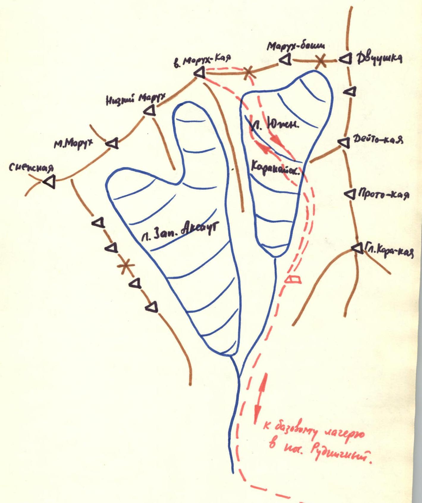
Climbing Area Map
Brief Description of the Approach to the Route
The closest area for mountaineering bases is Dombay, which is well connected to the upper reaches of the Aksaut valley by various pass routes.
The branch of the Dombay tourist camp - "Aksaut" and the KSP of the Aksaut area are based near the settlement "Rudnichny", which is connected to Karachaevsk and, accordingly, Dombay by a road. The road 3-5 km from Rudnichny settlement is subject to flooding by the Aksaut river during heavy rains.
From Rudnichny settlement to the moraine of the North Aksaut glacier - 2 hours by trail, then to the right along the riverbed flowing from the South Karakai glacier to the lateral moraine - 2 hours - bivouac.
The Marukh-Kaya peak is located between the peaks Marukh-Bashi and Nizkiy Marukh and is part of the Main Caucasian Ridge system.
The northeast slope of the peak is a rocky wall dropping into the South Karakai glacier cirque.
The northwest slope of Marukh-Kaya is icy, with a steepness of up to 45° in its upper part.
From the South Karakai glacier cirque, a couloir leads to the lower point of the ridge connecting the peaks Marukh-Bashi and Marukh-Kaya, ending in a snow cornice.
No information about ascents to the Marukh-Kaya peak was found in the Dombay and Aksaut KSP or in mountaineering literature.
Table
Main characteristics of the ascent route:
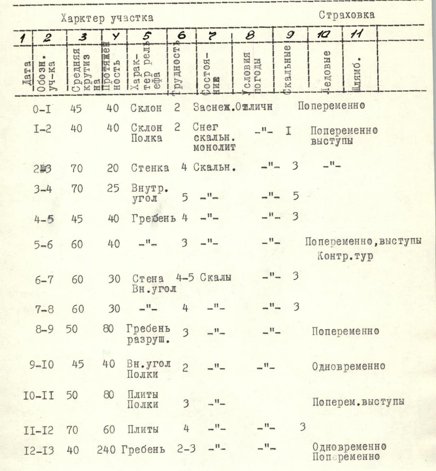
Brief Explanation of the Table
The ascent was planned to be completed in one day with a descent through the saddle between the peaks Marukh-Kaya and Marukh-Bashi.
The NE wall of Marukh-Kaya was previously inspected and the ascent route and main landmarks were identified. In the middle part of the ridge leading from the saddle to the peak, there is a noticeable shoulder from which smoothed slabs descend three rope lengths down.
To the right of the slabs and below the ridge, a huge ledge is visible, appearing triangular from the South Karakai glacier cirque. Under the slabs, to the left of the ledge and slightly to the right, there is a widening buttress bounded by couloirs on the left and right. Under the right couloir is a rocky outcrop, clearly visible from the cirque. The lower edge of the outcrop coincides with the lower edge of the bergschrund.
The main direction of the route: From the cirque through the bergschrund to the rocky outcrop, far up to the left to the shoulder of the buttress, and then, staying on the buttress, to the slabs under the shoulder of the ridge and along them to the ridge.
When traversing the wall section of the route, it was decided to avoid couloirs and internal corners as much as possible to minimize rockfall hazard.
From the South Karakai glacier moraine, on the right side of the glacier (in the direction of travel), there is an exit into the cirque under the peaks Marukh-Kaya and Marukh-Bashi. The cirque is crossed in the direction of the rocky outcrop under the wall of Marukh-Kaya. Up a steep snowy slope 150-170 m - exit under the rocky outcrop. The bergschrund is overcome in the direction of the base of the wall.
Comments
Sign in to leave a comment