6
0Tibetan Plateau
Mountain range1,759,588.46 km²
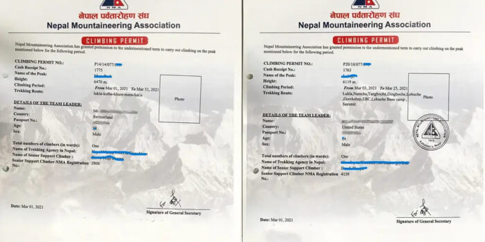
Nepal: Obtaining Permit for Solo Ascent in Restricted Areas
 ELEvgenii Lepikhin
Opportunities for solo ascents of unclimbed peaks in Nepal, permit regulations, and new summits open to alpinism in 2024.
A query from a reader (ExplorersWeb's reader — editor's note) planning a trip to Upper Mustang drew our attention to the hurdles independent climbers face when planning their Himalayan projects, especially solo ascents or attempts on unclimbed peaks in restricted areas. We reached out to a Nepalese tour operator for clarification on obtaining such permits.
Q&A
Matt Powell from the US asked:
I was hoping you could provide me with some clarification regarding Nepal's rules for solo climbers, particularly in restricted areas such as Upper Mustang and the Nar Phu valley. Is it possible for a single climber (myself) to obtain a permit to climb a peak in a restricted area if I use the services of a Nepalese guide? And if so, how do I go about it? Dawa Stephen Sherpa clarified that it is possible. However, he added, the climber must obtain the permit through a registered and certified trekking agency in Nepal. The main question, however, lies in what permits the climber needs and what are the requirements for each. It turns out that it depends on the height of the peak and involves various permits and procedures.
Expedition Peaks
Peaks above 6,500 m are considered expedition peaks and require a permit and the presence of a sirdar/guide and liaison officer on the expedition, increasing the cost. Permits for these peaks are issued by the Department of Tourism, under the Ministry of Culture, Tourism, and Civil Aviation of Nepal.
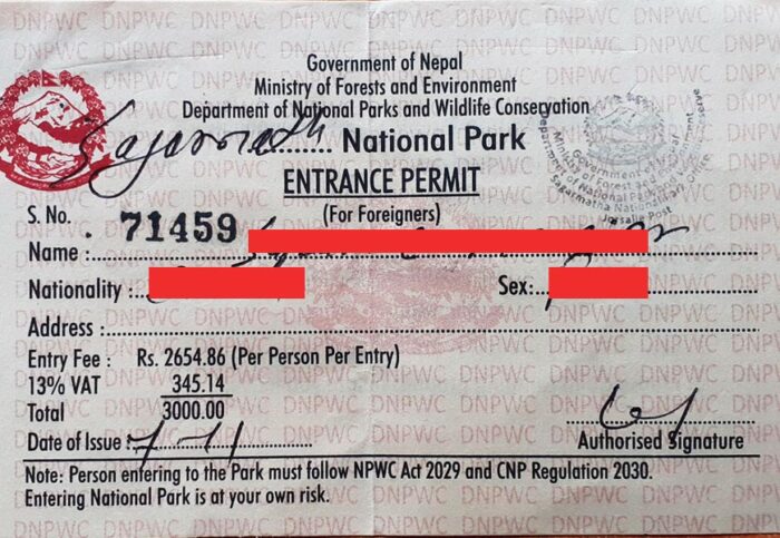 Once the climber has paid for the permit, the agency receives a letter from the Department of Tourism, which must be presented to the immigration department, issuing a second permit: the Restricted Area Permit (RAP). This allows the climber to enter the restricted zone at no additional cost, since they have already paid for the climbing permit.
Route Description: В гребню
 SSummitMate
Description of the ascent to Sarykuyakudzi peak (6220) via the eastern ridge in the Kongur Muztagh range in Chinese Pamir, with a complexity category of 5A, completed in 2007.
11.3.16
1. Ascent Passport
- Area: Kongur Muztagh Range (Chinese Pamir). Valley: Kengsuvar Section number according to the 2001 classification table – 11.3
- Peak name: Sarykayakudji. Route name: Via the Eastern Ridge
- Category of difficulty – proposed 5A.
- Route type: ice and snow.
- Height difference of the route: 828 m (according to GPS readings).
0
0Route Description: центр. кф. СВ стены
SSummitMate
Report on the first ascent of the route "Think Twice" on the Central Buttress of the NE wall of Muztagh Tower (7273 m) in Karakoram, made by the team of the Moscow Federation of Alpinism and Climbing in 2012.
Russian Alpinism Championship 2012. High-altitude ascents class
Ascent Report
of the Moscow Alpine and Climbing Federation team to Muztagh-Tower (7273 m) via the Central Buttress of the Northeast Face, "Think Twice" route — first ascent, approximately 6B category of difficulty Dedicated to the memory of Pavel Kozek, who perished on the slopes of Muztagh-Tower on August 25, 2008 Senior coach: S. Kotachkov, team leader: S. Nilov Moscow 2012
Ascent Passport
- Karakoram, Pakistan — section 10.2 according to KMGV 2008
0
0Route Description: Ю гребню
SSummitMate
Report on the first ascent of Mузтаг-Ата via the South Ridge, category 5B.
Moscow Federation of Alpinism and Rock Climbing
Report
On the first ascent to Muztag-Ata (7546) via the south ridge
Moscow, MAI Tourism Club, 2005
1. Ascent Passport
- Region: Kongur Muztagh Range (Chinese Pamir). Valley: Kalaxung, classification table section number for 2001 — 11.3
- Peak name: Muztag-Ata. Route name: via the south ridge from Kalaxung Glacier.
- Proposed category: 5B.
0
0Route Description: Ю гребню
SSummitMate
Ascent description of Muztagh Ata (7546 m) summit via the southern ridge in 2005, complexity category 5B, snow and ice route.
Ascent Passport
- Region: Eastern Pamir, China, section 11.3 of the classification table.
- Peak name: Muztag Ata, 7546 m, route: via the South Ridge.
- Proposed category: 5B category of difficulty, first ascent.
- Route type: ice and snow.
- Route elevation gain: approximately 1450 m. Route length: approximately 3200 m. Length of sections with 5th category of difficulty: 20 m. Average slope:
- main part of the route – approximately 45°,
0
0Route Description: СЗ гребню
SSummitMate
Description of the ascent via an alpinist route of the 5A category of difficulty via the northwestern ridge of the Mutztag Ata peak (Kunlun Mountains, China) in 2004.
Ascent Passport
- Region: China — Kunlun, Kongur Muztagh range. Section number according to the classification table 11.3.
- Peak name: Muztag Ata. Route name: via the Northwest Ridge
- Route classified by FASIЛ KР: 5A category of difficulty, first ascent
- Route character: snow-ice
- Height difference of the route: 3450 m. Route length: 14000 m. Length of section V category of difficulty ___________ m, VI category of difficulty ___________ m. Average steepness 30°
- Pitons left on the route: total ___________ including piton hangers ___________. Use of pitons on the route:
0
0Route Description: с запада
SSummitMate
Ascent of Muztagh Ata (7546 m) via the West Ridge, grade 5A, made by a Russian team in 1997.
Passport
- Class: High-altitude technical
- Eastern Pamir, Kashgar Mountains (western China)
- Peak Muztag-Ata (7546 m) via the western ridge, cat. diff. 5A
- Proposed cat. diff. 5B (possibly the 3rd ascent by a purely Russian team)
- Height difference — 3000 m, length — 9000 m, average slope — 20°
- Used pitons, 6 ice screws
- Climbing days — 3.5–5 (including descent to base camp)
- Overnights:
- 1st in tents on a rocky platform
0
0Route Description: В гребню с л. Ю Чимген
SSummitMate
Report on the first ascent by a Russian climbing team via the east ridge of Peak Kyzylsel (6,525 m) in the Kongur Muztagh range in 2000.
1. Climbing Passport
- Region: Kongur Muztagh Range (Kunlun). Gorge: Chimgan. Section number according to the 1999 classification table No. 11.3
- Name of the summit: Pik Kyzylsel Route name: via the eastern ridge from the South Chimgan Glacier.
- Proposed — 5A category of difficulty
- Route type: Ice and snow
- Height difference of the route: 1685 m (by altimeter). Route length: 4712 m. Section length:
- 5th cat. diff. – 2 m
0
0Route Description: кф. СЗ стены
SSummitMate
Report on the ascent of Kongur (7719) via the counterfort C-3 on the wall, category 6A route in "Alpine" style.
Report
On the Ascent to Kongur Peak (7719)
Via the NW buttress of the NW wall ("Moscow Express") 6A category of difficulty (Third passage of the route)
1. Climbing Passport
- Region: Kongur-Muztagh Range (Chinese Pamir). Valley: Karayaylak Section number according to the 2001 classification table — 11.3
- Summit name: Kongur. Route name: Via the NW buttress of the NW wall ("Moscow Express")
- Category of difficulty — 6A.
0
0Route Description: кф. СЗ стены
SSummitMate
Report on the first ascent of the route "Moskovsky Ekspress" 6A category of complexity on Kongur Tagh (7719 m) in 2004.
Open XIII CIS Championship (EAMA) in Alpinism 2004
EURO-ASIAN ALPINISM AND ROCK CLIMBING ASSOCIATION
11.3.6A
High-Altitude Technical Class
Report
on the ascent of Kongur Tagh (7719 m) at the Open XIII CIS Championship (EAMA) in Alpinism 2004 Team of the Moscow Federation of Alpinism and Rock Climbing Leader: Vyacheslav V. Odokhovsky Expedition Leader: Yuri V. Khokhlov
0
0Showing 1–10 of 14 results