
11.3.16
1. Ascent Passport
- Area: Kongur Muztagh Range (Chinese Pamir). Valley: Kengsuvar Section number according to the 2001 classification table – 11.3
- Peak name: Sarykayakudji. Route name: Via the Eastern Ridge
- Category of difficulty – proposed 5A.
- Route type: ice and snow.
- Height difference of the route: 828 m (according to GPS readings).
Route length: main part of the route – 907 m, total route – 2102 m.
Length of sections:
- Category IV difficulty – 1028 m
- Category V difficulty – 263 m
- Category VI difficulty – 30 m. Average steepness: main part of the route – 34°, total route – 25°.
- Number of pitons used on the route: rock – 0, ice – 32, including ITO – 0. Drill pitons (stationary, removable) were not used.
- Team's total climbing hours: 25 hours (3 days).
- Team leader: Lebedev Andrey Alexandrovich (Moscow), Master of Sports of International Class (tourism), 1st sports category (alpinism). Team members: Babich Mikhail Vasilievich (St. Petersburg), Candidate Master of Sports (tourism), Bezditko Sergey Vasilievich (Moscow), Master of Sports of International Class (tourism), 1st sports category (alpinism), Belyaeva Tatyana Andreevna (St. Petersburg), Candidate Master of Sports (tourism), Zharov Andrey Viktorovich (Moscow, Zelenograd), 1st sports category (tourism), Zhdanov Ivan Nikolaevich (Moscow), 1st sports category (tourism), Komarov Dmitry Alexandrovich (Moscow), 1st sports category (tourism), Maksimovich Yuri Alexandrovich (Moscow), Candidate Master of Sports (tourism), Timoshenkov Alexey Sergeevich (Moscow, Zelenograd), 1st sports category (tourism), 2nd sports category (alpinism), Chizhik Dmitry Vladimirovich (Moscow), Candidate Master of Sports (tourism), 2nd sports category (alpinism).
- Coach: Khokhlov Yuri Vladimirovich (Moscow), Master of Sports (alpinism).
- Departure to the route: 8:30 AM, August 9, 2007. Summit attainment: 12:00 PM, August 11, 2007. Descent to the Ortoterek glacier: 5:30 PM, August 11, 2007.
The ascent was carried out without prior route processing in "alpine" style and was implemented as a traverse of the summit as part of a 6B category sports mountain trip, registered for the Russian tourism championship. Route book № RG-610-06/07, approved on July 4, 2007, by the MKK TSSR, see also a brief report on the trip [1].
2. Peak Photograph
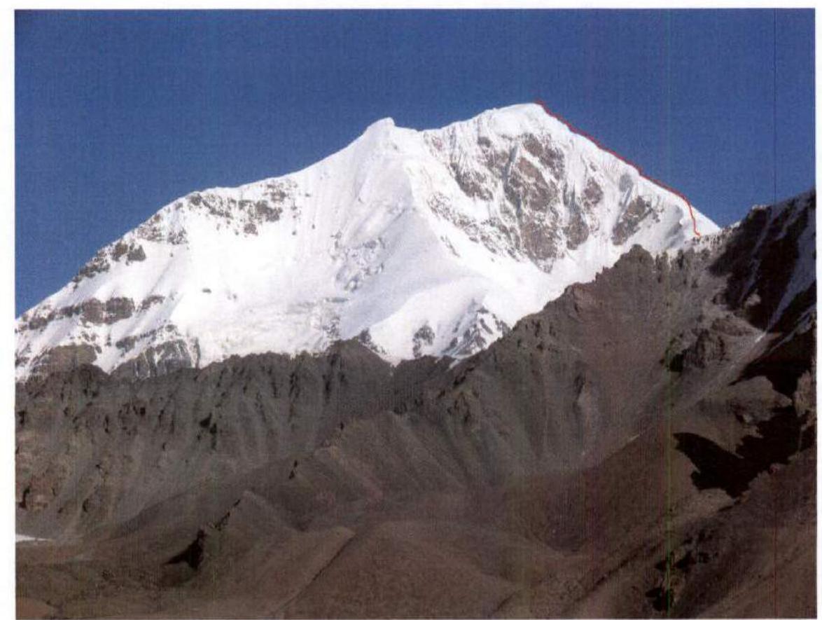 2.1. View from the southeast from the Osypnoy Pass (4606) in the spur separating the Central and South Chat glaciers. Taken on August 4, 2007. Right – the eastern ridge.
 2.2. View from the southeast from the Kengsuvar glacier plateau. Taken on August 8, 2007. Right – the eastern ridge.
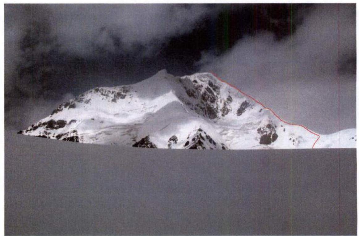
 2.3. View from the north from the eastern ridge of Peak Kyzylsel (6525). Taken in August 2000.
Tracks:
2.3. View from the north from the eastern ridge of Peak Kyzylsel (6525). Taken in August 2000.
Tracks:
- Red – path along the eastern ridge;
- Blue – first ascent route along the northern ridge by the British expedition in 1980 (led by C. Bonington).
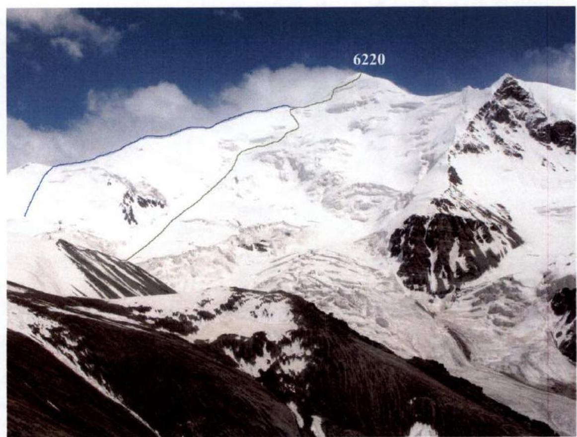 2.4. View from the northwest from the Granatovyi Pass (5215) in the spur separating the Ortoterek and Olavulk glaciers. Taken on August 12, 2007.
Tracks:
2.4. View from the northwest from the Granatovyi Pass (5215) in the spur separating the Ortoterek and Olavulk glaciers. Taken on August 12, 2007.
Tracks:
- Blue – C. Bonington's route along the northern ridge (1980);
- Green – our team's descent route (2007).
3. Route Profile Photograph
View from the north from the eastern ridge of Peak Kyzylsel (6525). Taken in August 2000.
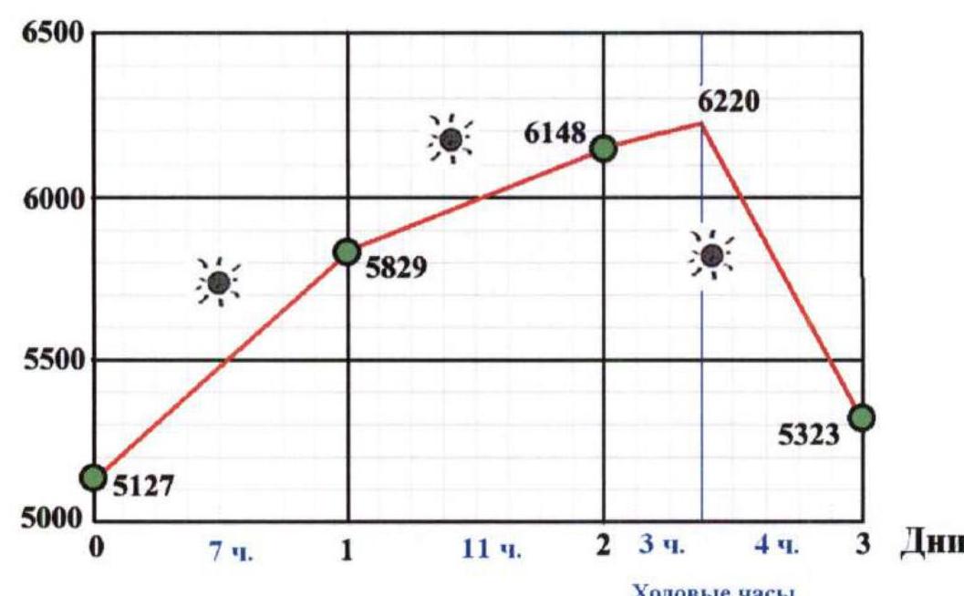
4. Hand-Drawn Route Profile
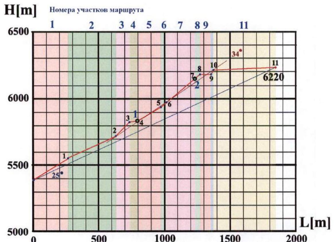
Large blue numbers along the graph – camp numbers. Small black numbers along the graph – route section numbers (marked at the ends of corresponding sections).

5. Area Photopanorama
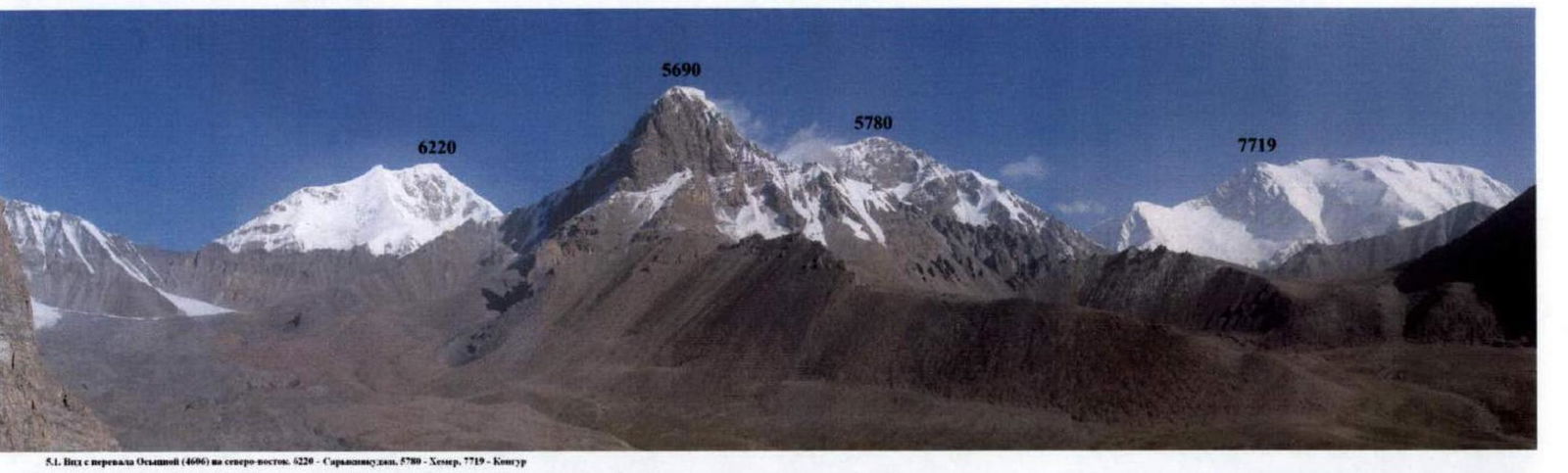
5.1. View from the Osypnoy Pass (4606) to the northeast: 6220 – Saryknikudaki, 5780 – Khemer, 7719 – Kontur.
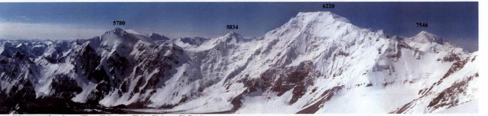
5.2. View from the eastern ridge of Peak Kyzylsel (6525) to the peaks:
- 6220 – Saryinnikudaki
- 5780 – Khemer
- 5834 – Otadzhuruk
- 7546 – Muzgar-Ata
6. Description of Sarykayakudji Peak
Sarykayakudji Peak (6220) and a chain of three "six-thousanders" to the south of Kongur is located in the Kongur Muztagh Range (Kashgar Mountains, Chinese Pamir). The peak is formed by Koksel (6715), Kyzylsel (6525), and Sarykayakudji (6220).
The first ascent on Sarykayakudji was made by a British expedition led by C. Bonington during their first trip to the Kashgar Mountains in 1980. Climbers ascended to the summit along the northern ridge. The ridge was accessed from the west, from the Ortoterek glacier.
The same glacier allows access to the western ridge of the peak. It is possible to reach the Ortoterek glacier tongue from Lake Karakul by caravan (1 day's journey along the Shivakhoda River valley).
The western, southern, south-eastern, and eastern ridges of the peak are accessible from the Kengsuvar glacier. This glacier can also be reached by caravan from Lake Karakul (1 day's journey along the Kengshiberisu River valley). The exception is the north-eastern wall of the peak, which rises above the Sogato glacier and is accessible only from the north-east from the Chimgan valley.
Our team reached the Kengsuvar glacier plateau through a relatively easy Euler Pass (5215 m) from the Chat valley, following the declared alternative option in the tourist route.
The weather in the Kongurtagh area is determined not only by Atlantic cyclones. Unlike the Badakhshan Pamir, which is shielded from the south by the high ridges of the Hindu Kush, monsoons from the Indian Ocean (from the south along the Indus valley and the Khudoraabad pass) and from the Pacific Ocean (from south-eastern China) penetrate here. Therefore, the weather is less stable and approaches the weather in the area of Peak Pobeda. Prolonged anticyclones are practically absent here. On average, the weather changes every 3-4 days. As a result, there is little open ice in the area, a deep snow cover, and it is avalanche-prone. The snow cover is particularly challenging for movement at altitudes of 5200-6000 m. Higher up, the snow is compacted by strong winds and partially blown away.

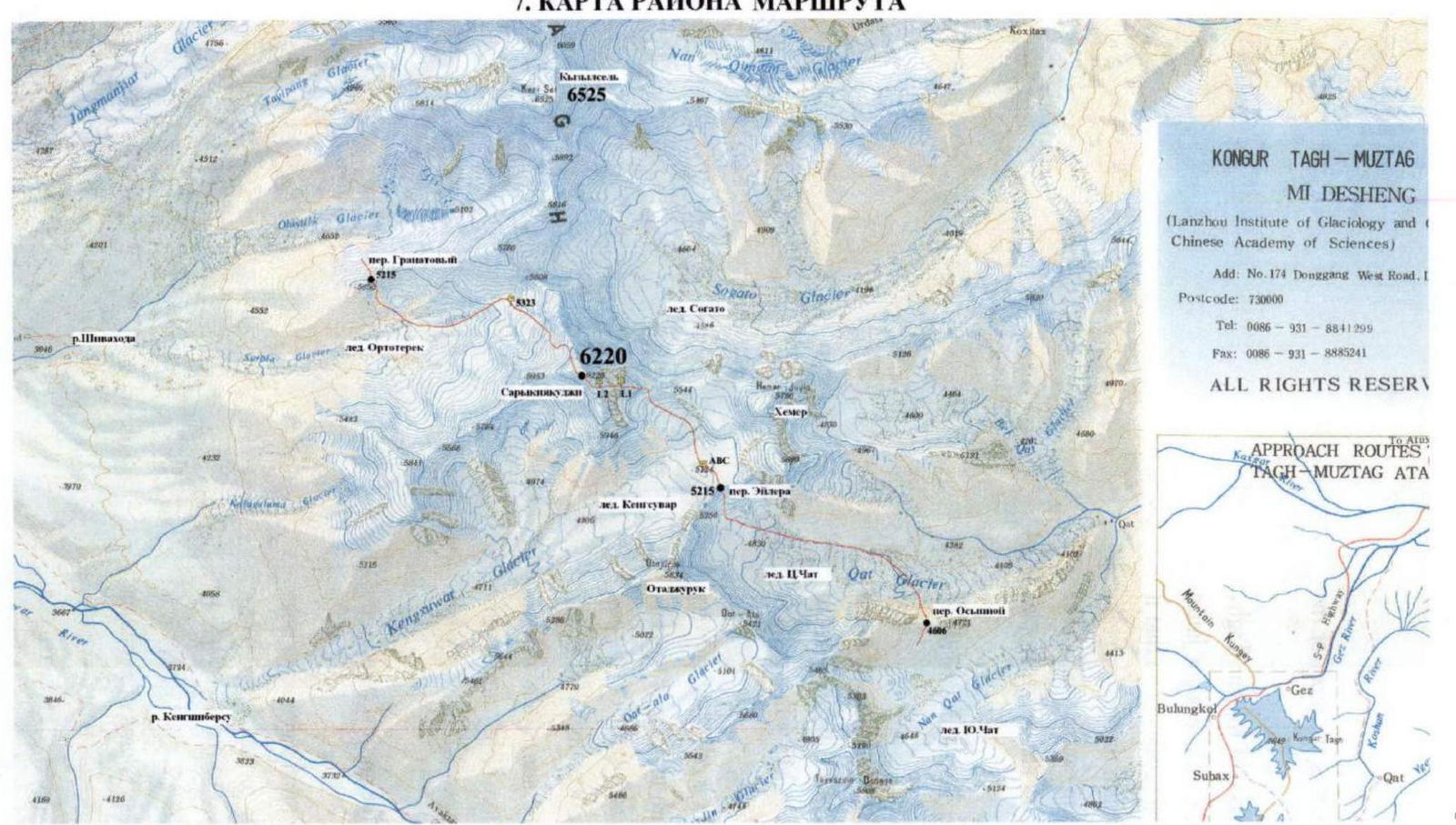
7. Route Area Map
8. Ascent Schedule
| Table 1. Daily Transitions | ||||
|---|---|---|---|---|
| Date | Climbing time [hours] | Ascent [m] | Height difference [m] | Transition name |
| 09.08 | 7 | 702 | 5127–5829 | ABC – C1 (sections R1–R4) |
| 10.08 | 11 | 319 | 5829–6148 | C1–C2 (sections R5–R7) |
| 11.08 | 3 + 4 (descent) | 78 | 6148–6220–5323 | C2 – summit, descent (sections R8–R11 + descent) |
Height Profile
9. Route Scheme
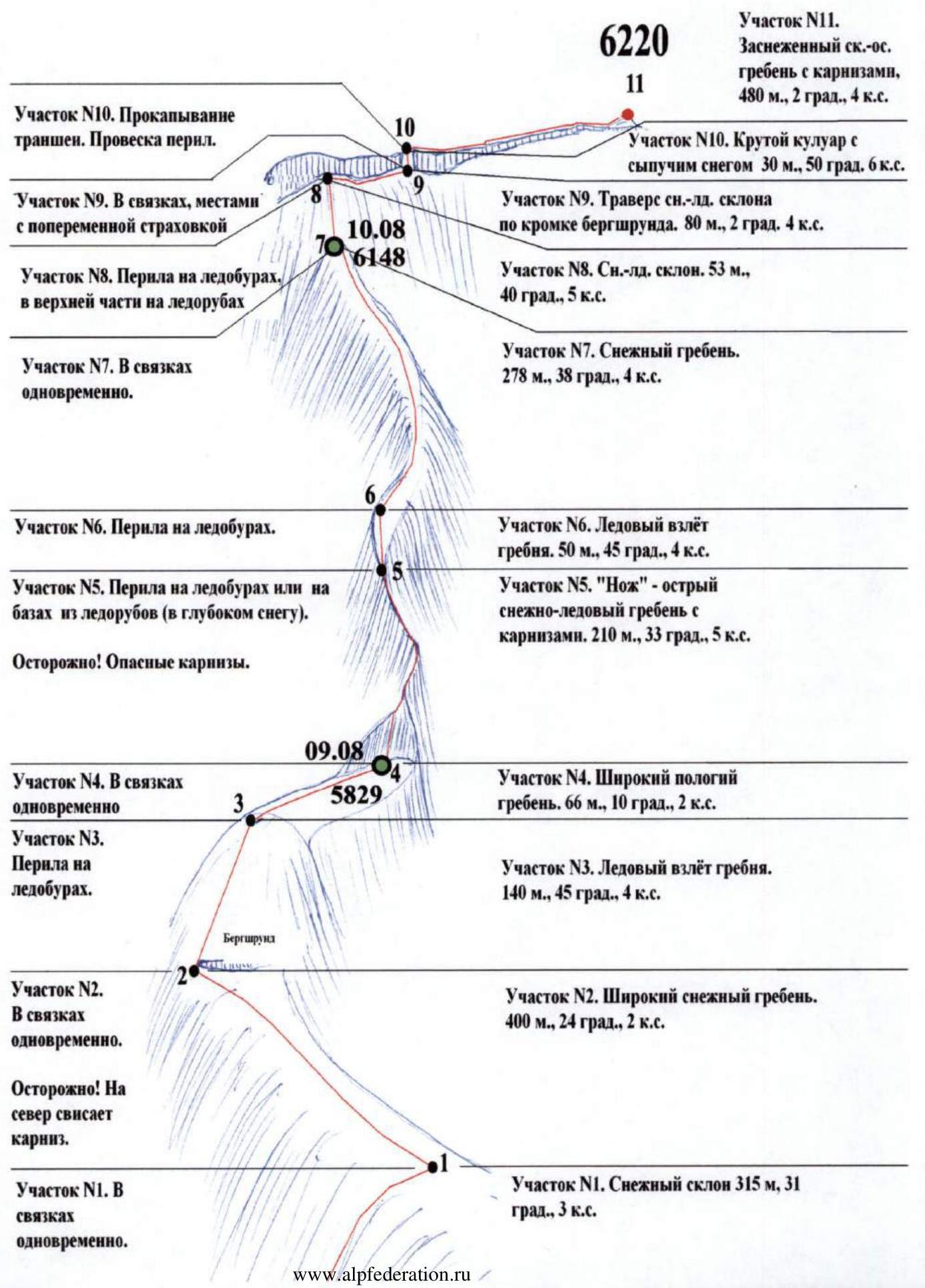
Section R10. Trench excavation. Rappel setup. Section R11. Snowy rock-ice ridge with cornices, 480 m, 2 grad., 4. Section R10. Steep couloir with loose snow 30 m, 50 grad., 6. Section R9. In rope teams, sometimes with running belay. Section R9. Traverse of snow-ice slope along the edge of the bergschrund. 80 m, 2 grad., 4. Section R8. Rappel on ice screws, in the upper part on ice axes. Section R8. Snow-ice slope. 53 m, 40 grad., 5. Section R7. In rope teams simultaneously. Section R7. Snow ridge. 278 m, 38 grad., 4. Section R6. Rappel on ice screws. Section R6. Ice ledge on the ridge. 50 m, 45 grad., 4. Section R5. Rappel on ice screws or on bases made of ice axes (in deep snow). Section R5. "Knife" – sharp snow-ice ridge with cornices. 210 m, 33 grad., 5. Caution! Dangerous cornices. Section R4. In rope teams simultaneously. Section R4. Wide, gentle ridge. 66 m, 10 grad., 2. Section R3. Rappel on ice screws. Section R3. Ice ledge on the ridge. 140 m, 45 grad., 4. Section R2. In rope teams simultaneously. Section R2. Wide snow ridge. 400 m, 24 grad., 2. Caution! Cornice hangs to the north. Section R1. In rope teams simultaneously. Section R1. Snow slope 315 m, 31 grad., 3.
10. Route Section Breakdown
| Table 2. Route Sections | |||||||
|---|---|---|---|---|---|---|---|
| N | Section description | Start height [m] | End height [m] | Technical difficulty | Difficulty with altitude | Length [m] | Average steepness [grad.] |
| 1 | Snow slope | 5392 | 5554 | 2 | 3 | 315 | 31 |
| 2 | Wide snow ridge | 5554 | 5719 | 1 | 2 | 400 | 24 |
| 3 | Ice ledge on ridge | 5719 | 5818 | 3 | 4 | 140 | 45 |
| 4 | Wide, gentle ridge | 5818 | 5829 | 1 | 2 | 66 | 10 |
| 5 | "Knife" – sharp snow-ice ridge with cornices | 5829 | 5943 | 4 | 5 | 210 | 33 |
| 6 | Ice ledge on ridge | 5943 | 5978 | 3 | 4 | 50 | 45 |
| 7 | Snow ridge | 5978 | 6148 | 2 | 4 | 278 | 38 |
| 8 | Snow-ice slope | 6148 | 6182 | 3 | 5 | 53 | 40 |
| 9 | Traverse of snow-ice slope along bergschrund edge | 6182 | 6185 | 2 | 4 | 80 | 2 |
| 10 | Steep couloir with deep loose snow | 6185 | 6206 | 3–4 | 5–6 | 30 | 50 |
| 11 | Snowy rock-ice ridge with cornices | 6206 | 6220 | 2 | 4 | 480 | 2 |
Average steepness of the route – 25°. Average steepness of the main part of the route (sections R3–R10) is 34°. Route length – 2102 m. Length of the main part of the route (sections R3–R10) – 907 m. Total length of category IV difficulty sections – 1028 m. Total length of category V difficulty sections – 263 m. Length of category VI difficulty section – 30 m.
11. Technical Route Photograph
 11.1. Sections R2–R8. View of the route from the southeast, from the Kengsuvar glacier plateau. Taken on August 8, 2007.
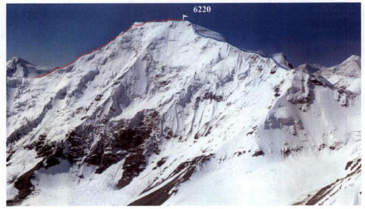
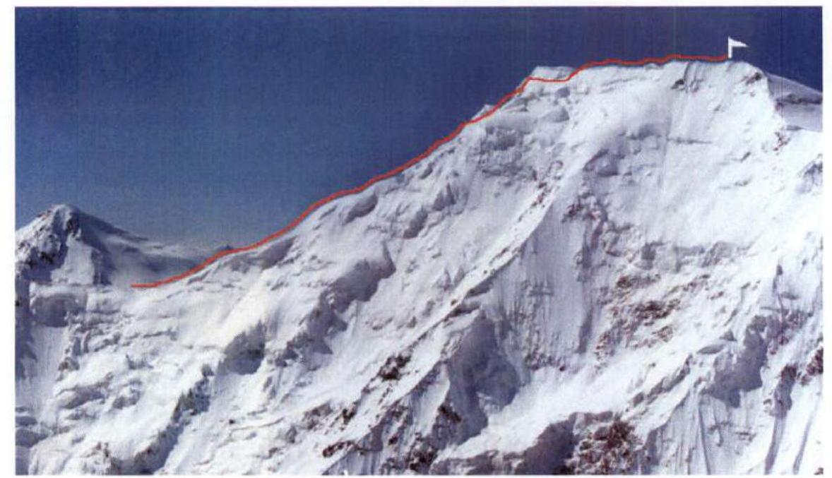
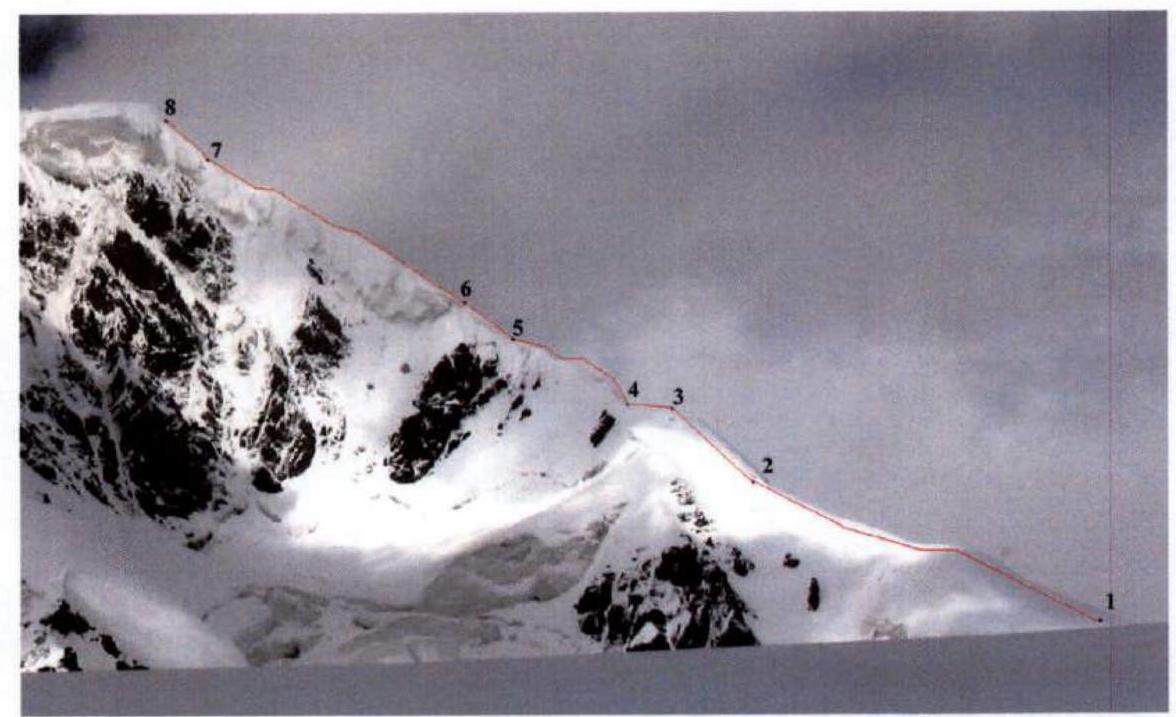
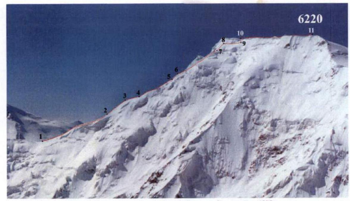 11.2. Sections R2–R11. View of the route from the north, from the eastern ridge of Peak Kyzylsel (6525). Taken in August 2000.
12. Photo Illustrations
 F.1. Ascent to the ridge (section R1).
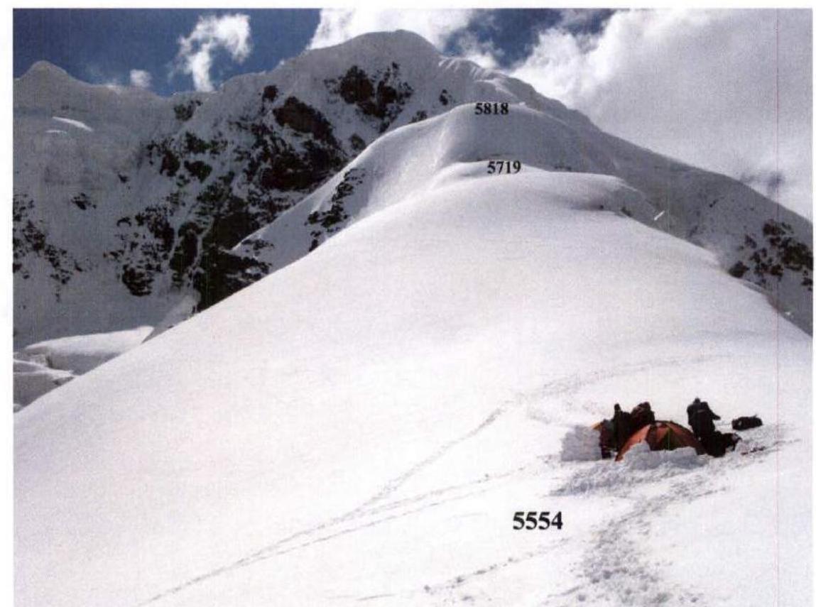 F.2. Lunch on the ridge at the beginning of section R2 (5554–5719). Ahead, beyond the break, is the ice ledge – section R3 (5719–5818).
 F.3. At the beginning of section R3.
 F.4. In camp 1 (5829). Ahead is section R5.
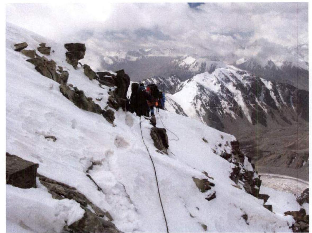
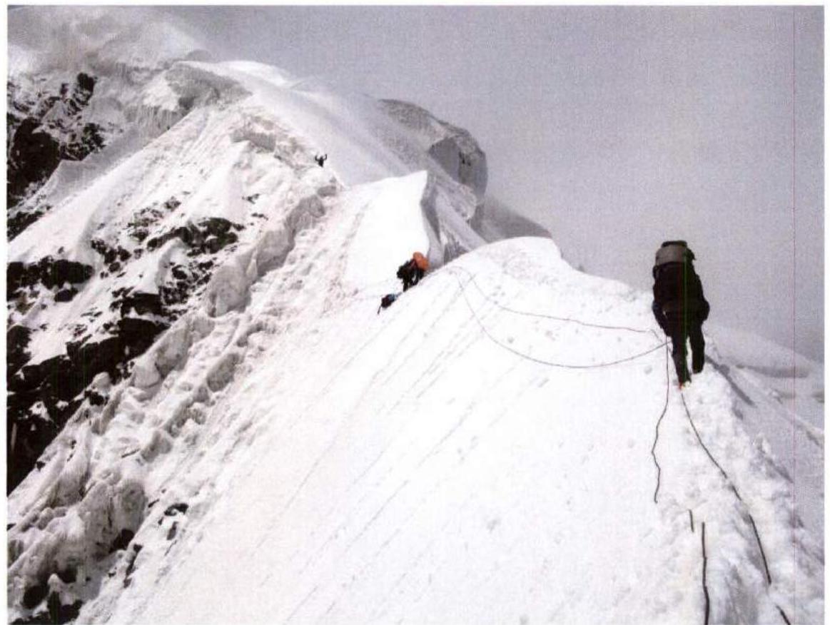 F.5. On section R5.
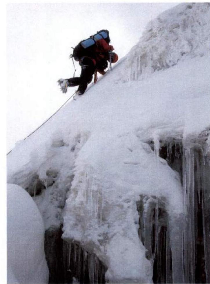
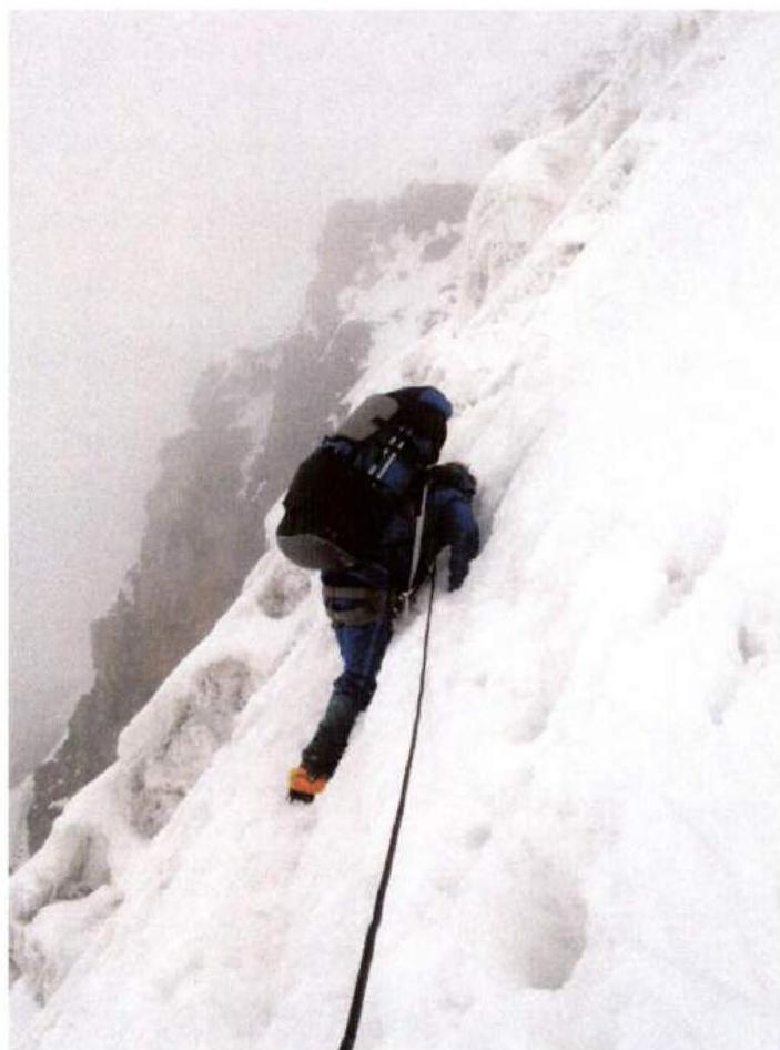 F.6. Bypassing an ice belay on section R5.
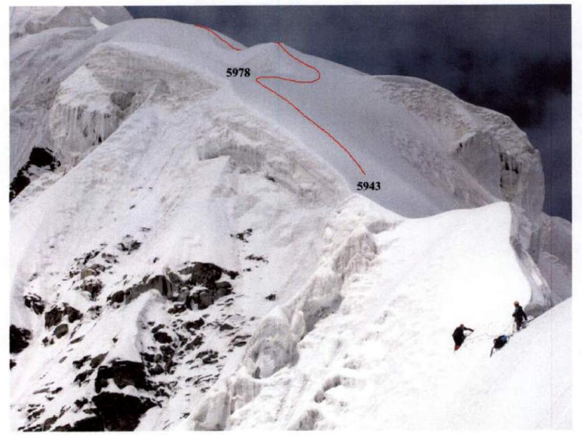 F.7. At the end of section R5. Ahead is section R6 (5943–5978).
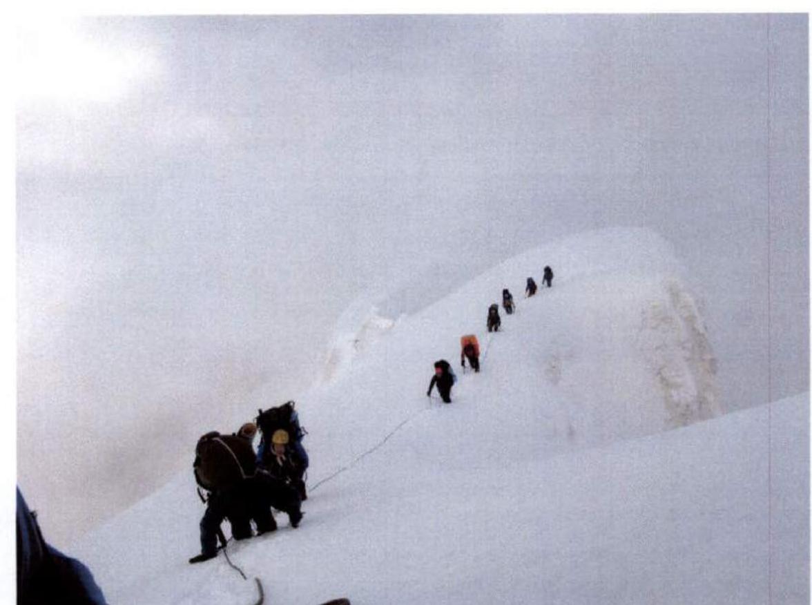 F.8. At the beginning of section R7.
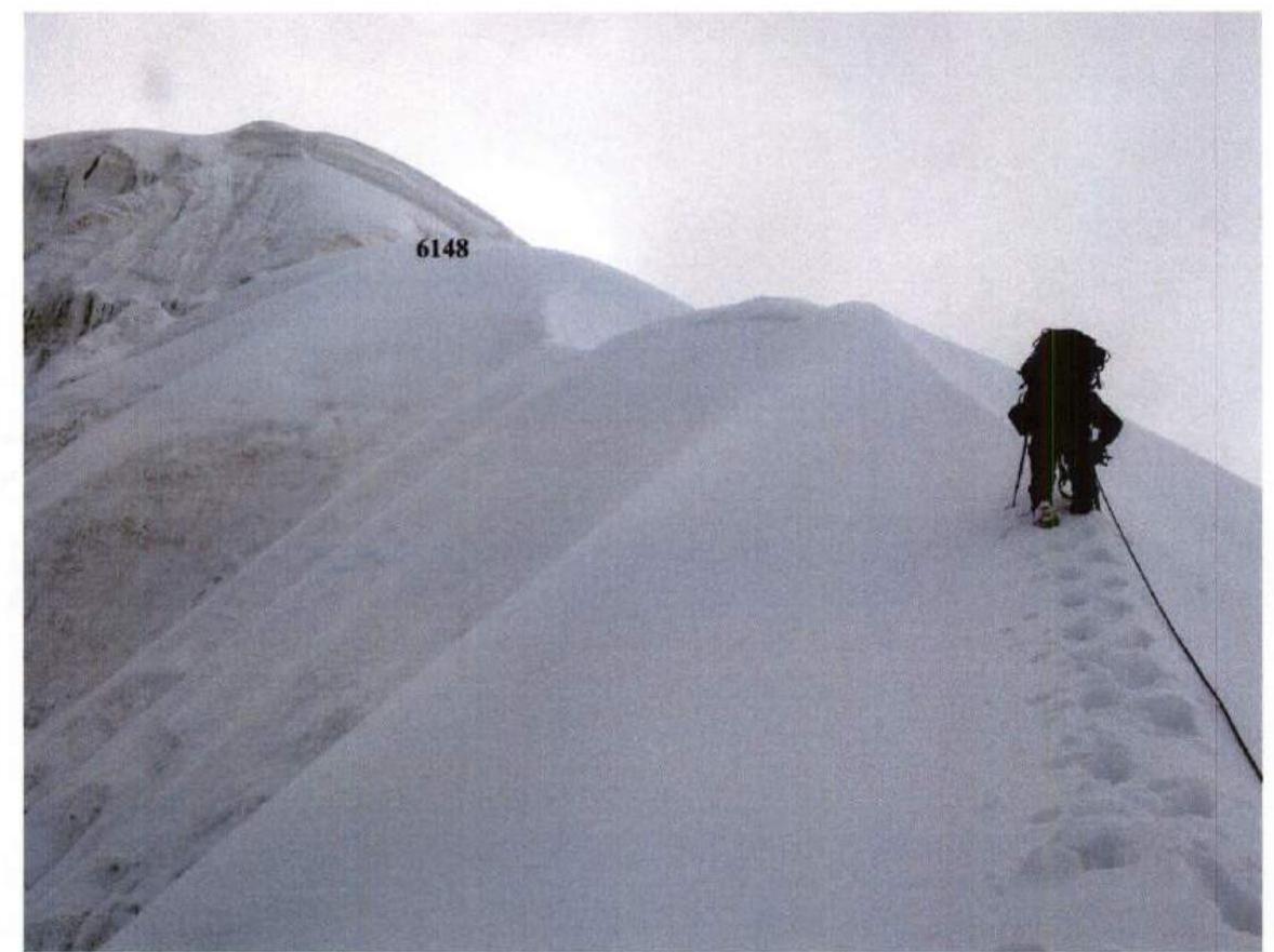 F.9. On section R7. Ahead is camp 6148, followed by section R8.
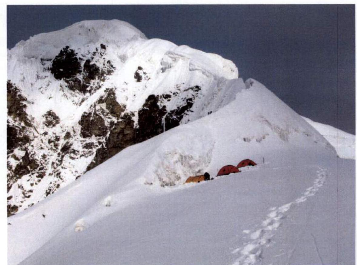
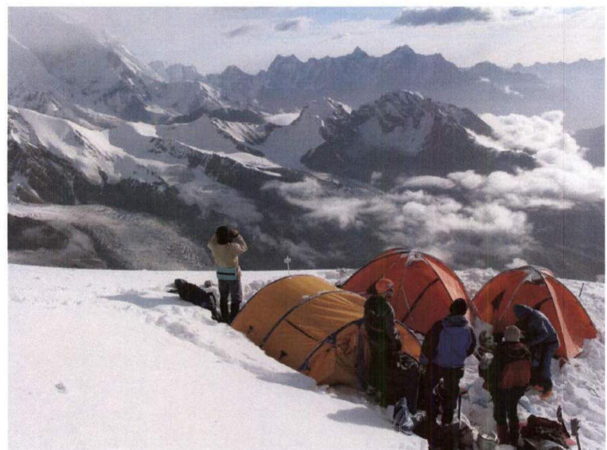 F.10. Morning in camp 6148.
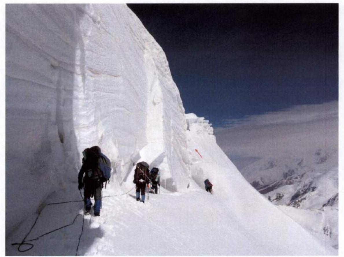 F.11. On the traverse under the icefall (section R9). The arrow indicates the path through the couloir to the summit ridge (section R10).
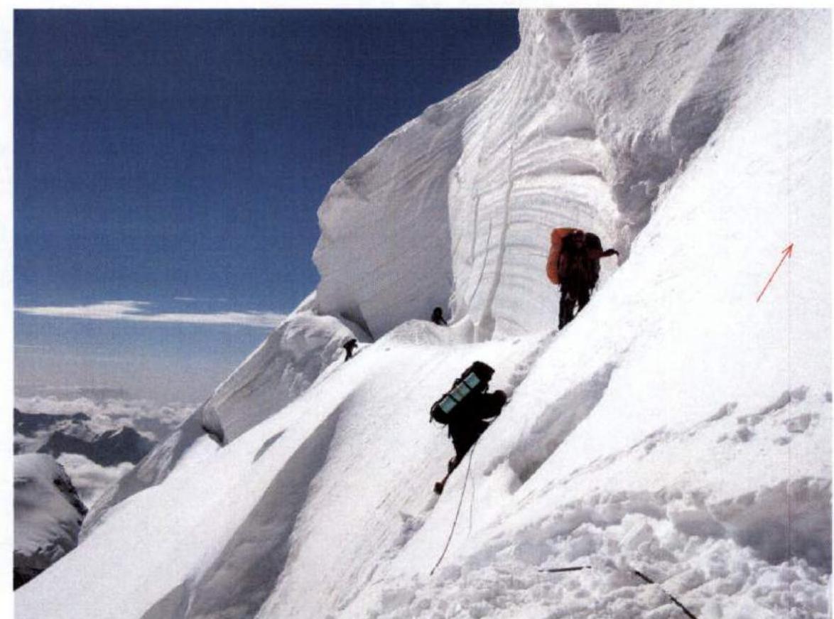 F.12. On the traverse under the icefall (section R9). The arrow on the right indicates the path through the couloir to the summit ridge (section R10).
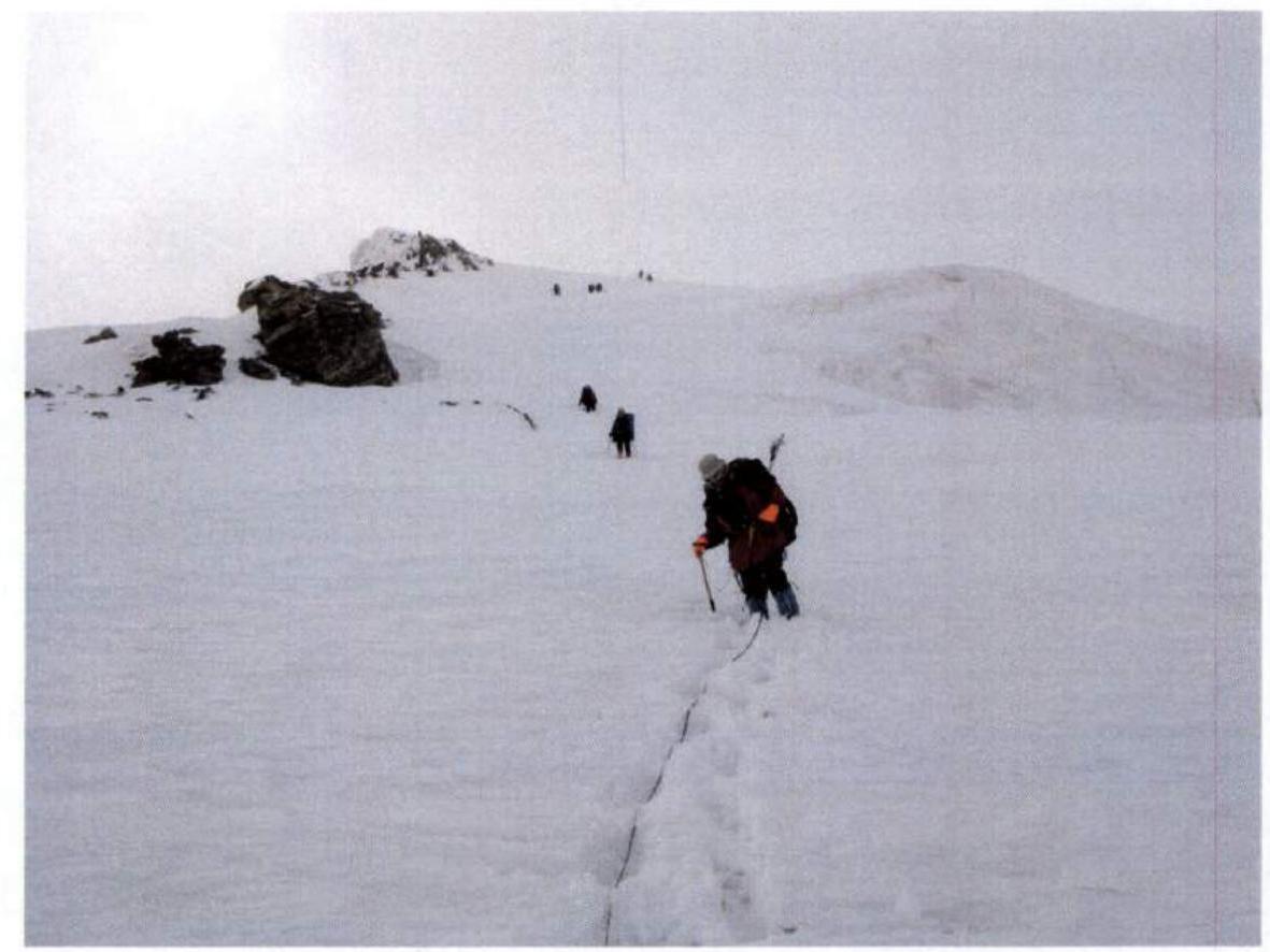
 F.13. On the summit ridge (section R11).
 F.14. On the summit ridge (section R11).
 F.15. Beginning of descent from the summit along the northern ridge.
13. References
- A. Lebedev. Brief report on a mountain trip to Chinese Pamir with an ascent to Kongur. (http://www.turclubmai.ru/heading/papers/1463/ ↗)
Comments
Sign in to leave a comment