
Moscow Federation of Alpinism and Rock Climbing
Report
On the first ascent to Muztag-Ata (7546) via the south ridge
Moscow, MAI Tourism Club, 2005
1. Ascent Passport
- Region: Kongur Muztagh Range (Chinese Pamir).
Valley: Kalaxung, classification table section number for 2001 — 11.3
- Peak name: Muztag-Ata.
Route name: via the south ridge from Kalaxung Glacier.
- Proposed category: 5B.
- Route type: snow-ice.
- Route elevation gain: 1500 m (by altimeter)
Route length: 3928 m. Section lengths:
- Category V: 1200 m
- Category VI: 0 m. Average slope: 24°, main part of the route — 30°.
- Number of pitons used on the route: 0
- Team's total climbing hours: 24 h 30 min, 3.5 days.
- Team leader: Lebedev Andrey Alexandrovich (Moscow), Master of Sports (tourism), 1st category (alpinism)
Team members:
- Kagan Vladislav Evgenievich (Minsk), 1st category (alpinism)
- Tarakanovskaya Marina Anatolievna (Novosibirsk), 1st category (tourism)
- Chizhik Dmitry Vladimirovich (Moscow), 1st category (tourism)
- Yudin Petr Vladimirovich (Novosibirsk), Candidate Master of Sports (tourism)
- Yanchevsky Oleg Zigmontovich (Kiev), Candidate Master of Sports (tourism).
- Coach: Lebedev Andrey Alexandrovich.
- Departure for the route: 9:00, September 2, 2005.
Summit reached: 12:05, September 5, 2005. Descent to Subashi meadow (4116): 14:30, September 6, 2005. The ascent was part of a category 6B mountaineering trip entered in the Russian tourism championship. Route book No. 1/3-603, approved on June 29, 2005 by MKK FT Moscow, see also the trip report [1].
The ascent was conducted in alpine style, the team reached the summit at 12:05 on the fourth day of climbing (38th day of the trip).
2. Peak photographs
Photographs from the west (approach side) often do not show the southern ridge of Muztag-Ata. We provide photographs of the peak from three projections: south, west, and east, thus providing comprehensive information.
Fig.1.1. Muztag-Ata from the south. Photo by A. Mashenin from the north ridge of Koskolak peak.
1 — route via the south ridge, 2 — route via the east ridge (D. Mazur, 2000). Taken in August 2005. Fig.1.2. Muztag-Ata from the west. Photo by Alexander Ershov from Subashi meadow. 1 — upper, part of the route via the south ridge, 3 — route via the south edge of the west slope (E. Beletsky, 1956), 4 — route via the north edge of the west slope (commercial classic). Taken on June 3, 2005. Fig.1.3. Muztag-Ata from the east. Photo by A. Lebedev from the southern branch of Koksel Glacier.
1 — route via the south ridge, 2 — route via the east ridge (D. Mazur, 2000). Taken in August 2002.
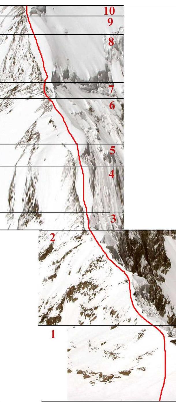
3. Route profile photograph
 Fig.2. View of the south ridge of Muztag-Ata from the east from the plateau of the southern branch of Koksel Glacier (photo by A. Lebedev, August 2002). Red numbers mark the ends of corresponding sections.
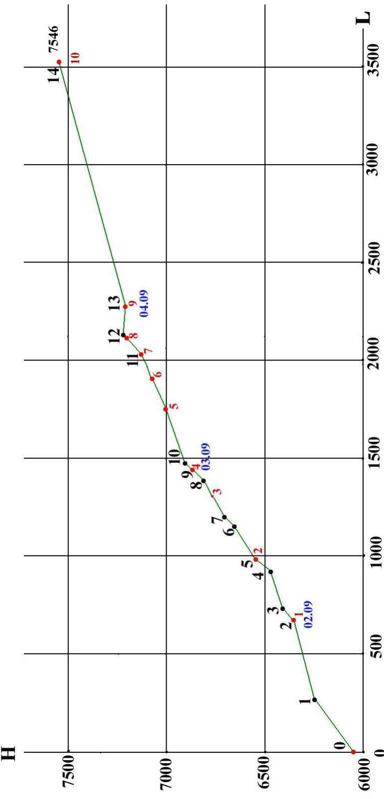
4. Hand-drawn route profile
Black numbers mark the ends of route sections, see Table 2. Red numbers mark GPS points, see Table 3.
5. Area photopanorama
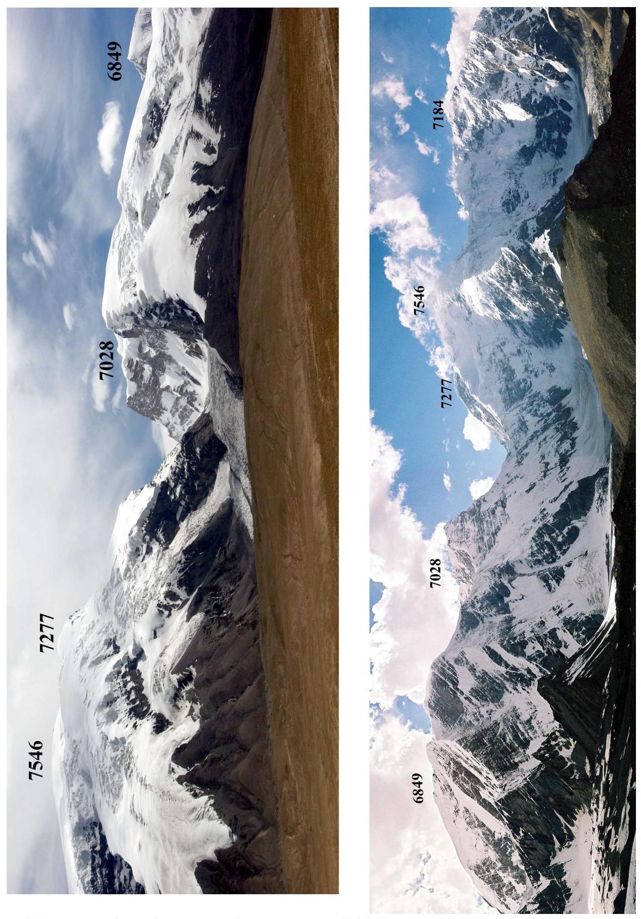 Fig.3.1. Muztag-Ata, Kalaxung, Koskolak, peak 6849 from the west (photo by A. Mashenin, August 2005). Fig.3.2. Peak 6849, Koskolak, Kalaxung, Muztag-Ata, and Kuksa from the east (photo by A. Lebedev, August 20, 2005).
6. General description of the Kongur Muztagh region
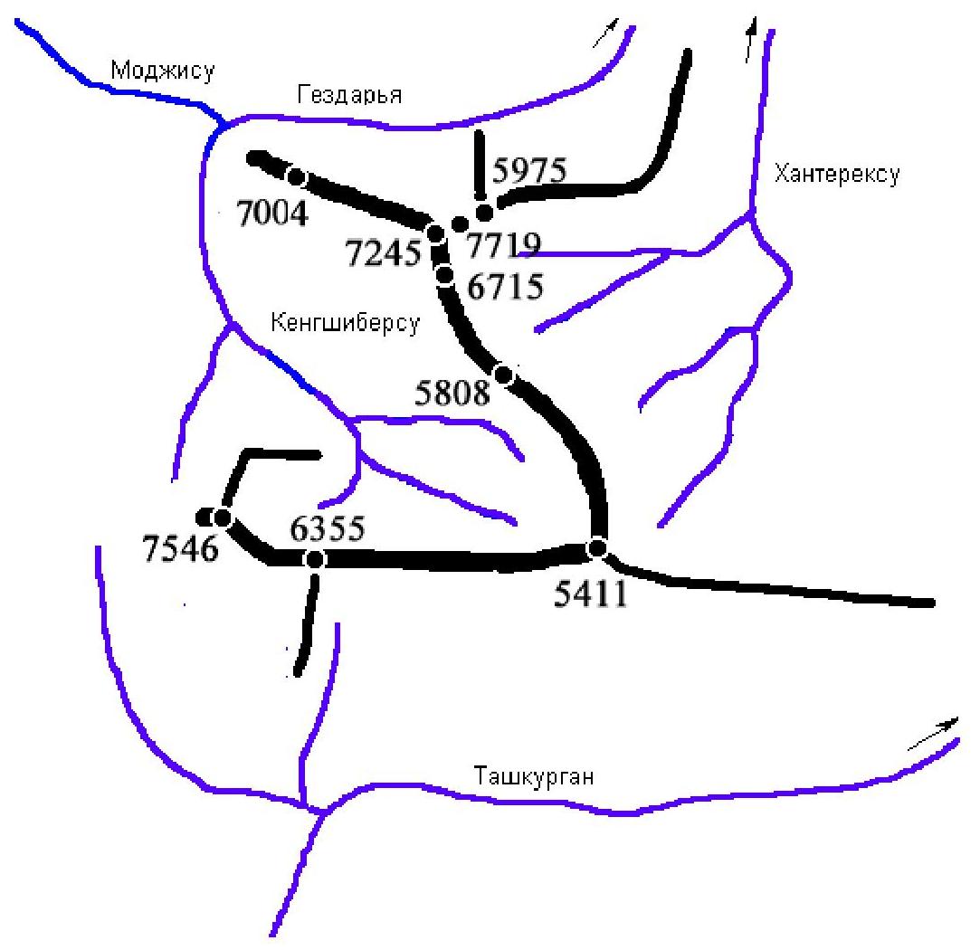
3.1. Orography and classification of sub-regions. The Kongur Muztagh range is located in the southeast of the Pamir and stretches from the Gözdar'ya valley in the north to the Tashkurgan valley in the south. It is bounded by the Kengshiber-su valley to the west and the Khanterek-su headwaters to the east. The Kongur Muztagh range has two large eastern spurs. The first branches off from the nodal peak Karayaylak (7245). The highest peak of the Pamir, Kongur (7719), is located at the base of this spur. The second spur branches off from the unnamed nodal peak 5411. Thus, the mountain region is divided into sections:
- Kongur Tagh. This section of the Kongur Muztagh range extends from the confluence of Mojisu and Kengshiber-su to the nodal peak Karayaylak (7245). The peak Kongur (7719) is naturally included in this section, forming the eastern shoulder of the grand wall of Kongur Tagh.
-
Agalystan Mountains. This is the name given to the eastern spur of Kongur (7719). It begins immediately behind the saddle ~5770 between Kongur and peak 5975 (V. Nikolaev peak) to the northeast of Kongur. The ridge height does not exceed 6000 m, with the highest peaks surpassing 5900 m. The Agalystan Mountains separate the Gözdar'ya and Khanterek-su basins.
-
Meridional section of the Kongur Muztagh range, extending from the nodal peak Karayaylak to the nodal peak 5411. This section separates the Kengshiber-su and Khanterek-su basins.
-
Eastern spur 5411, separating the Khanterek-su and Tashkurgan basins.
-
Southern section of Kongur Tagh, extending from the nodal peak 5411 in the east to Muztag-Ata (7546) in the west, separating the Kengshiber-su and Tashkurgan basins.
3.2. Weather in the Kongur Muztagh region is determined not only by Atlantic cyclones. Unlike the Badakhshan Pamir, which is shielded from the south by the high ridges of the Hindu Kush, this region is affected by monsoons from the Indian Ocean (from the south via the Indus valley and the Khudoraabad pass) and from the Pacific Ocean (from southeast China). Therefore, the weather here is less stable and approaches the weather in the Peak Victory region. Prolonged anticyclones are practically nonexistent. On average, the weather changes every 3–4 days. As a result, there is little open ice in the region, a deep snow cover, and a high risk of avalanches. The snow cover is particularly difficult to traverse at altitudes of 5200–6000 m. Higher up, the snow is compacted by strong winds and partially blown away.
3.3. General description of Muztag-Ata. Translated from Turkic, Muztag-Ata means "Father of Ice Mountains". It is the third highest peak in the Pamir after Kongur (7719) and Kongur-Tyube (7595). Muztag-Ata is located on the western edge of the southern section of the Kongur Muztagh range and "rises" from the plain with virtually no foothills. The western slope of the peak gently descends and smoothly transitions into chuqurs. Further west lies a flat plain — the "meadow" of Subashi, along which the Karakoram Highway (Kashgar—Tashkurgan—Gilgit) passes from north to south. The distance from the road to the glaciers of Muztag-Ata is no more than 10 km.
In the center of the western slope of the peak is a giant depression into which ice falls and feeds the Kartamak Glacier flowing down this depression. Accordingly, to the left and right of the depression, two "classic" routes ascend to the peak. The southern route was pioneered by the first ascenders in 1956 (E. Beletsky's route), and the northern route is currently the most popular and crowded, with access to the base camp possible by jeep. The base camp for the southern route along the western slope of Muztag-Ata is also located very close to the dirt road (about 4 km away).
To the north, Muztag-Ata is adjacent to Kuksa peak or North Muztag-Ata (7184), separated from its southern neighbor by the ridge 6875. Kuksa dominates the Kara-Kul lake and blocks the view of Muztag-Ata from the north and northwest. From the ridge 6875, a steep, rarely visited technical ridge leads to Muztag-Ata.
The unclimbed eastern 2-kilometer wall of Muztag-Ata and Kuksa is steep (55°) and rocky. To the south, it abuts the east ridge of Muztag-Ata, along which a new route was pioneered in 2000 by D. Mazur's team. The 2-kilometer wall between Muztag-Ata's east and south ridges is equally steep and unclimbed. The approach to Muztag-Ata from the east is made from Kara-Kul lake along Kengshiber-su and then along Koksel Glacier (3–4 days of travel).
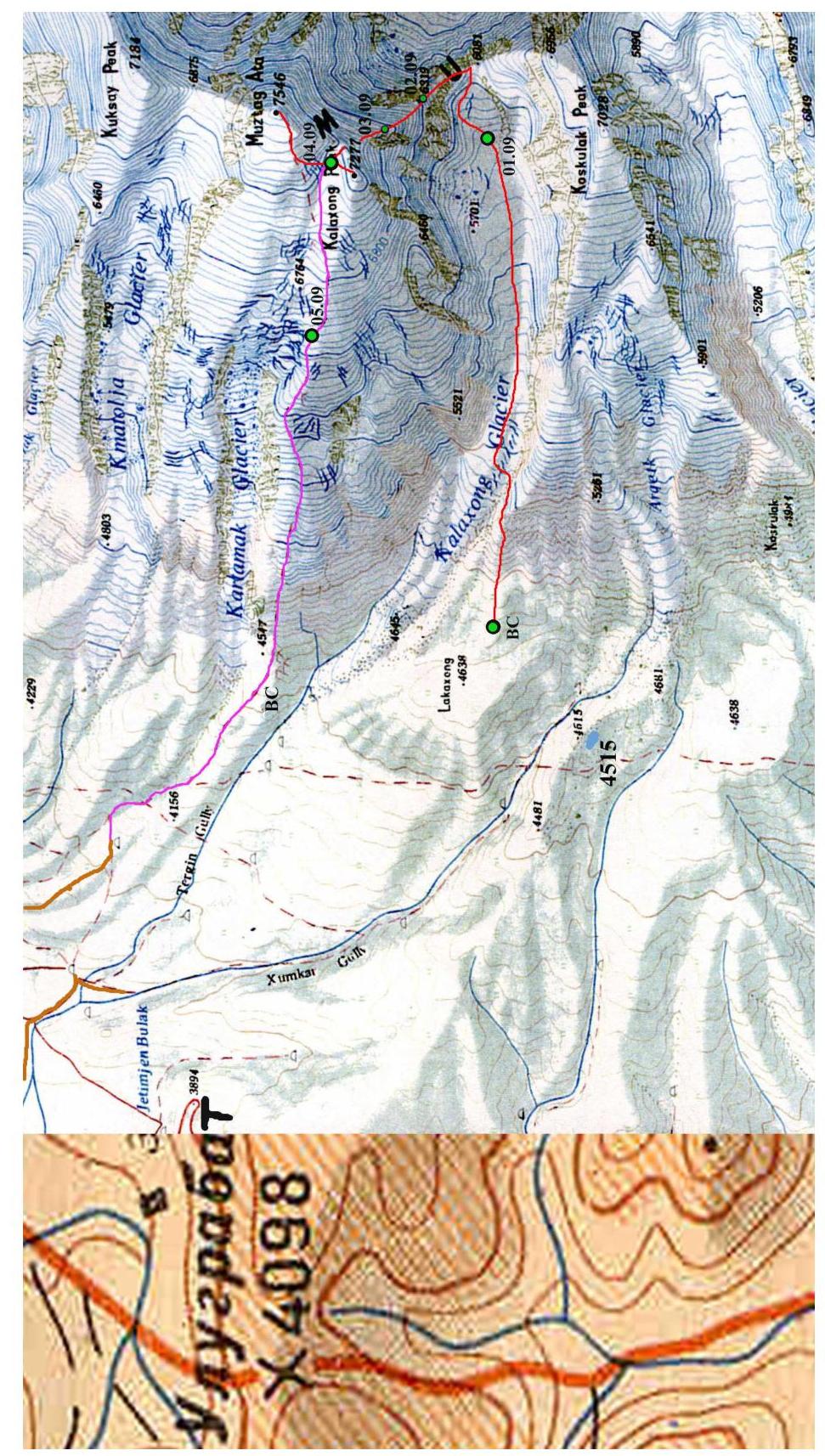
Muztag-Ata's southern neighbor is Koskolak peak (7028), first conquered in the summer of 2005. It is separated from Muztag-Ata by the ridge 6081. To the east, this ridge drops off with a 900-meter 55-degree wall, while to the west, the Kalaxung Glacier flows down relatively gently, providing the simplest path to the south ridge of the peak.
The south shoulder of Muztag-Ata (7277) is separated from the main peak by the ridge 7215 and is marked on the map as Kalaxong peak. The south ridge of the peak approaches this ridge.
During our ascent to Muztag-Ata, our team traversed the ridge 7215 from south to west, documenting it as "Kalaxong pass" in the records of the Russian Tourism Federation. Three of our team members, V. Kagan, D. Chizhik, and P. Yudin, additionally ascended to Kalaxong peak (7277), which could be considered a "first ascent" if Kalaxong were an independent peak.
The approach to the south ridge of Muztag-Ata can conveniently start from Koskolak's base camp. The gentle western slope of Koskolak peak at an altitude of about 4600–4800 m smoothly transitions into a high-altitude plateau. Here, at an altitude of 4515 m, there is a lake, to which a dirt road approaches from the west from the Karakoram Highway. The lake can also be reached via a mule trail from the northwest, starting from the southeastern corner (3850 m) of Subashi meadow. The water in the lake is not suitable for drinking due to the abundance of grazing livestock nearby. Therefore, it is more advisable to set up Koskolak's base camp 2.5 km northeast of the lake near a clean stream at an altitude of 4700 m. From here, it is convenient to start routes along the western slope of Koskolak, its north wall, and the south ridge of Muztag-Ata.
From Koskolak's base camp, ascend the scree slope of Koskolak to an altitude of 5100–5200 m and descend north to Kalaxung Glacier above its powerful icefall. A 7-kilometer path along the gentle glacier with virtually no ascent leads to the ridge 6081 at the base of Muztag-Ata's south ridge.
7. Route area map
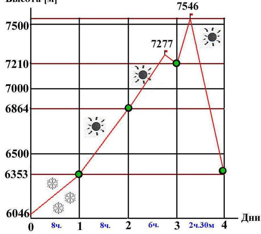
8. Ascent schedule
| Table 1. Daily transitions | ||||
|---|---|---|---|---|
| Date | Climbing time [h, min] | ascent [m] | Elevation gain [m] | Daily transition description |
| 02.09 | 8 ч 00 мин | 509 | 5844–6353 | Kalaxung Glacier — sections R1 and R2 |
| 03.09 | 8 ч 00 мин | 511 | 6353–6864 | Sections R3–R9 |
| 04.09 | 6 ч 00 мин | 351 | 6864–7215–7210 | Sections R10–R13 |
| 05.09 | 2 ч 30 мин вверх + 3 ч 00 мин вниз | 336 | 7210–7546–7210–6372 | Section R14, start of descent via west slope |
| 06.09 | 4 ч 30 мин | 0 | 6372–4116 | Descent to camping area |
Elevation [m]
9. Route diagram (1:10000)
| Alternating movement | |
|---|---|
| Alternating movement | |
| Simultaneous movement | |
| Simultaneous movement | |
| Simultaneous movement | |
| Alternating movement | |
| Simultaneous movement | |
| Alternating movement | |
| Dangerous cornices to the east! | |
| Complicated orientation in bad weather. | |
| Simultaneous movement in teams | |
| Dangerous cornices to the east! | |
| Simultaneous movement in teams |
Snow-ice slope. 5, 50 m, 46°. Snow-ice slope. 5, 80 m, 45°. Wide ridge. 4, 217 m, 30°. Destroyed rocks. 4, 72 m, 46°. Snow-ice ridge. 4, 200 m, 33°. Snow-ice ridge ascent. 5, 98 m, 50°. Wide snow ridge. 3, 200 m, 17°. Snow-ice ridge ascent. 5, 80 m, 43°. Snow ridge traverse with cornices and short ascents. 5, 420 m, 15.5° along the path and 30–35° to the left. Deep snow up to 1.5 m on ascents. Snow-ice ridge ascent with cornices. 5, 336 m, 36°.
10. Route section breakdown
| Table 2. Route sections | |||||||
|---|---|---|---|---|---|---|---|
| N | Section description | Start elevation [m] | End elevation [m] | Technical difficulty | Difficulty with elevation | Length [m] | Average slope [°] |
| 1 | Snow-ice ridge ascent | 6046 | 6242 | 3 | 5 | 336 | 36 |
| 2 | Snow-ice ridge traverse with cornices and short ascents | 6242 | 6353 | 3 | 5 | 420 | 15.5 (along path) 30–35 (left) |
| 3 | Snow-ice ridge ascent | 6353 | 6406 | 3 | 5 | 80 | 43 |
| 4 | Wide snow ridge | 6406 | 6464 | 1 | 3 | 200 | 17 |
| 5 | Snow-ice ridge ascent | 6464 | 6539 | 3 | 5 | 98 | 50 |
| 6 | Snow-ice ridge | 6539 | 6648 | 2 | 4 | 200 | 33 |
| 7 | Destroyed rocks | 6648 | 6700 | 2 | 4 | 72 | 46 |
| 8 | Wide snow-ice ridge | 6700 | 6808 | 2 | 4 | 217 | 30 |
| 9 | Snow-ice slope | 6808 | 6864 | 3 | 5 | 80 | 45 |
| 10 | Snow-ice slope | 6864 | 6900 | 3 | 5 | 50 | 46 |
| 11 | Snow-scree ridge | 6900 | 7120 | 1 | 3 | 600 | 21.5 |
| 12 | Snow-ice slope | 7120 | 7215 | 3 | 5 | 135 | 45 |
| 13 | Snow plateau | 7215 | 7180 | 0 | 2 | 145 | –4 |
| 14 | Snow slope | 7180 | 7546 | 1 | 3 | 1295 | 15.2 |
Average slope of the route — 24°. Average slope of the main part (sections R1–R12) — 30°.
Route length — 3928 m. Length of the main part (sections R1–R12) — 2488 m. Total length of category 5 sections — 1200 m.
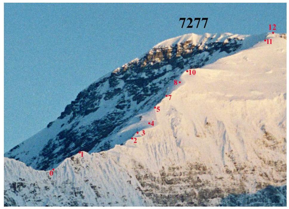 Fig.4. Section ends on the south ridge, view from the east from the plateau of the southern branch of Koksel Glacier (photo by A. Lebedev, August 2002).
 Fig.5. Satellite image of the area with section ends marked. Red line — ascent route, lilac — descent route.
| Table 3. GPS points (WGS-84 coordinate system) | |||||||
|---|---|---|---|---|---|---|---|
| Length of latitude minute — 1850 m. Length of longitude minute — 1450 m | |||||||
| N | Latitude | Longitude | Altitude | Name | Date | Distance | L |
| 0 | 3815013 | 7507315 | 6046 | Start of route (R0) | 02.09.2005 | 0 | |
| 1 | 3815343 | 7507110 | 6353 | Camp (R2) | 02.09.2005 | 680 | 680 |
| 2 | 3815459 | 7506957 | 6539 | End of R5 (R5) | 03.09.2005 | 310 | 990 |
| 3 | 3815596 | 7506822 | 6761 | Halt on R8 | 03.09.2005 | 320 | 1310 |
| 4 | 3815661 | 7506775 | 6864 | Camp (R9) | 03.09.2005 | 135 | 1445 |
| 5 | 3815809 | 7506676 | 7001 | Halt on R11 | 04.09.2005 | 310 | 1755 |
| 6 | 3815889 | 7506644 | 7073 | Halt on R11 | 04.09.2005 | 155 | 1910 |
| 7 | 3815954 | 7506616 | 7120 | End of R11 | 04.09.2005 | 125 | 2035 |
| 8 | 3815998 | 7506599 | 7201 | Halt in depression before ascent to R12 | 04.09.2005 | 85 | 2120 |
| 9 | 3816063 | 7506530 | 7207 | Camp (R13) | 04.09.2005 | 160 | 2280 |
| 10 | 3816541 | 7506970 | 7538 | Summit (R14) | 05.09.2005 | 1250 | 3530 |
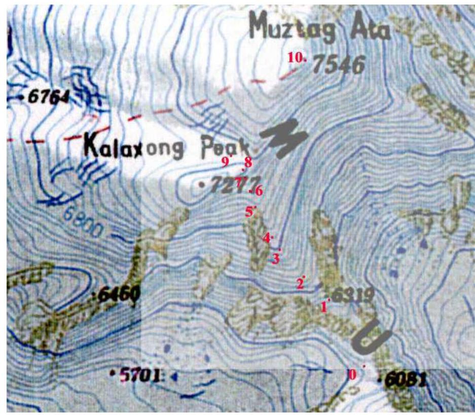
South ridge map with GPS points marked.
11. Technical photograph of the route
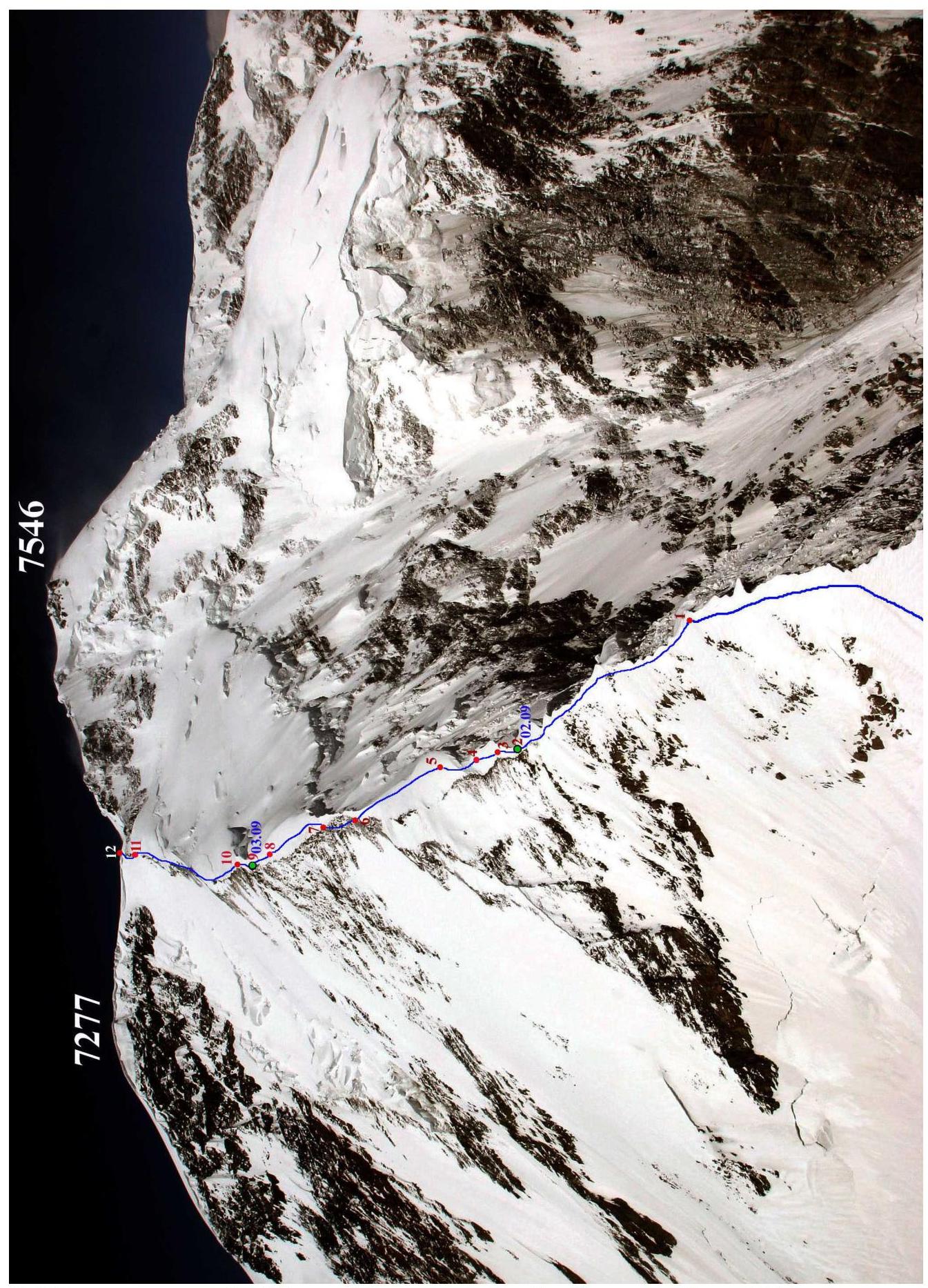 Fig.6. View of the south ridge of Muztag-Ata from the north ridge of Koskolak (photo by A. Mashenin, August 2005). Red numbers mark the ends of corresponding sections.
12. Photo illustrations
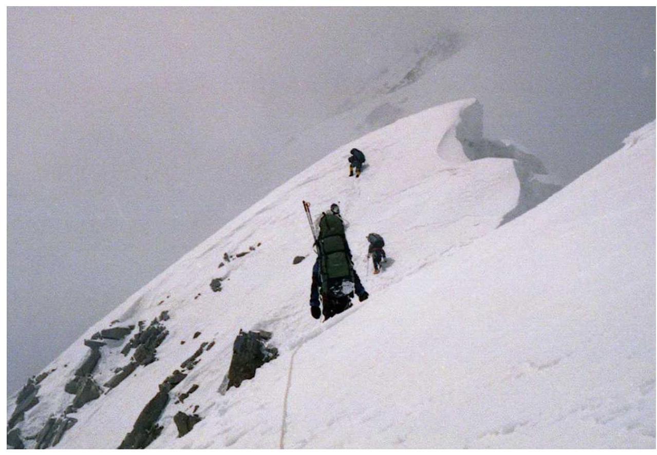 Fig.7. On section R2.
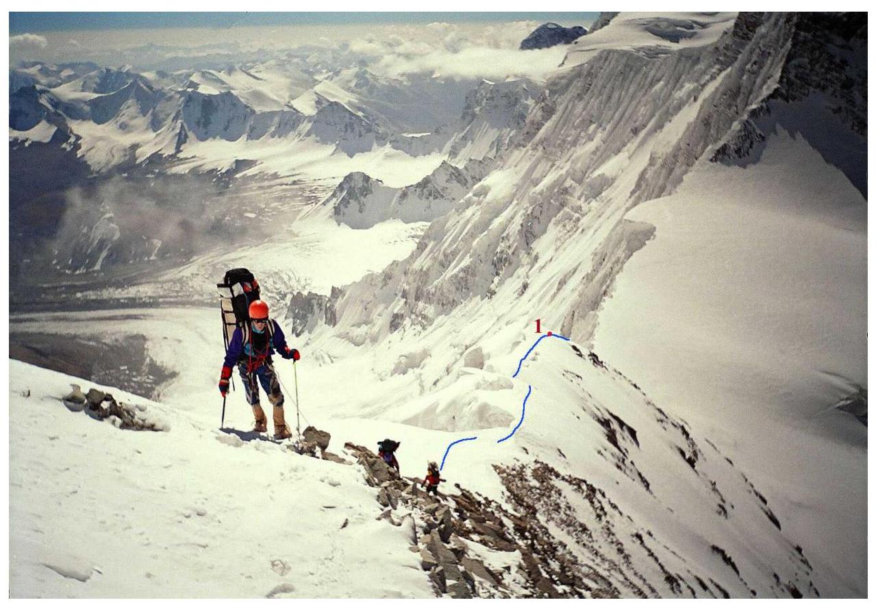 Fig.8. On section R4.
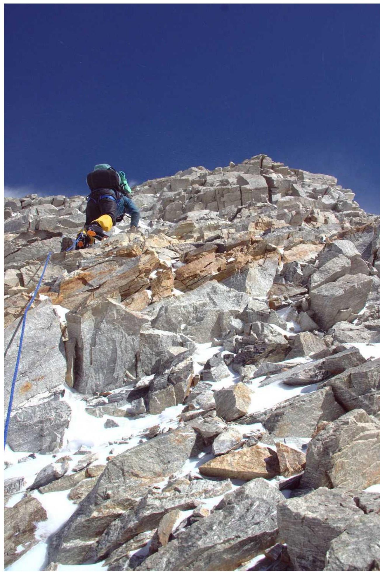 Fig.9. On section R7 (photo from 2011 ascent [2]).
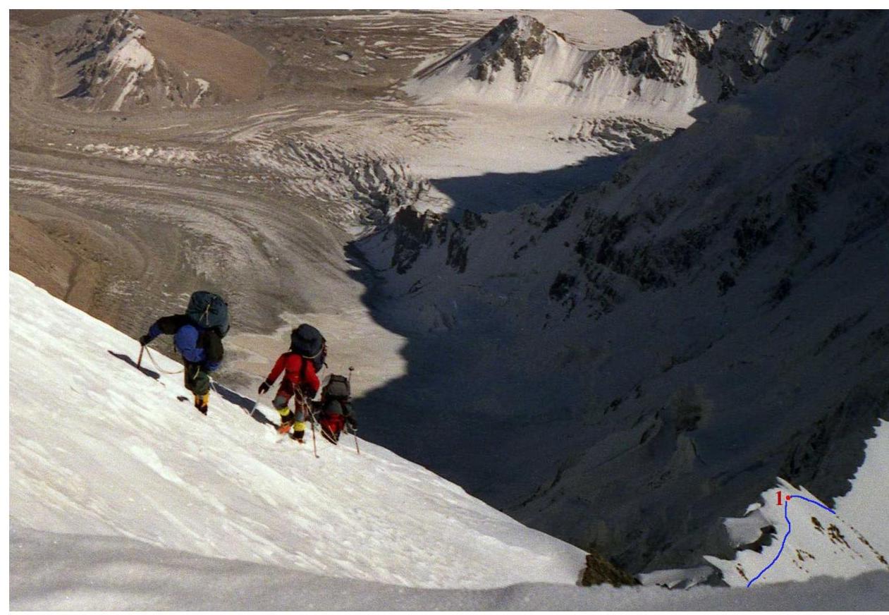 Fig.10. On section R8. Cornices of R2 visible at bottom right.
 Fig.11. Overcoming another ascent on Muztag-Ata's south ridge (2011 photo [2]).
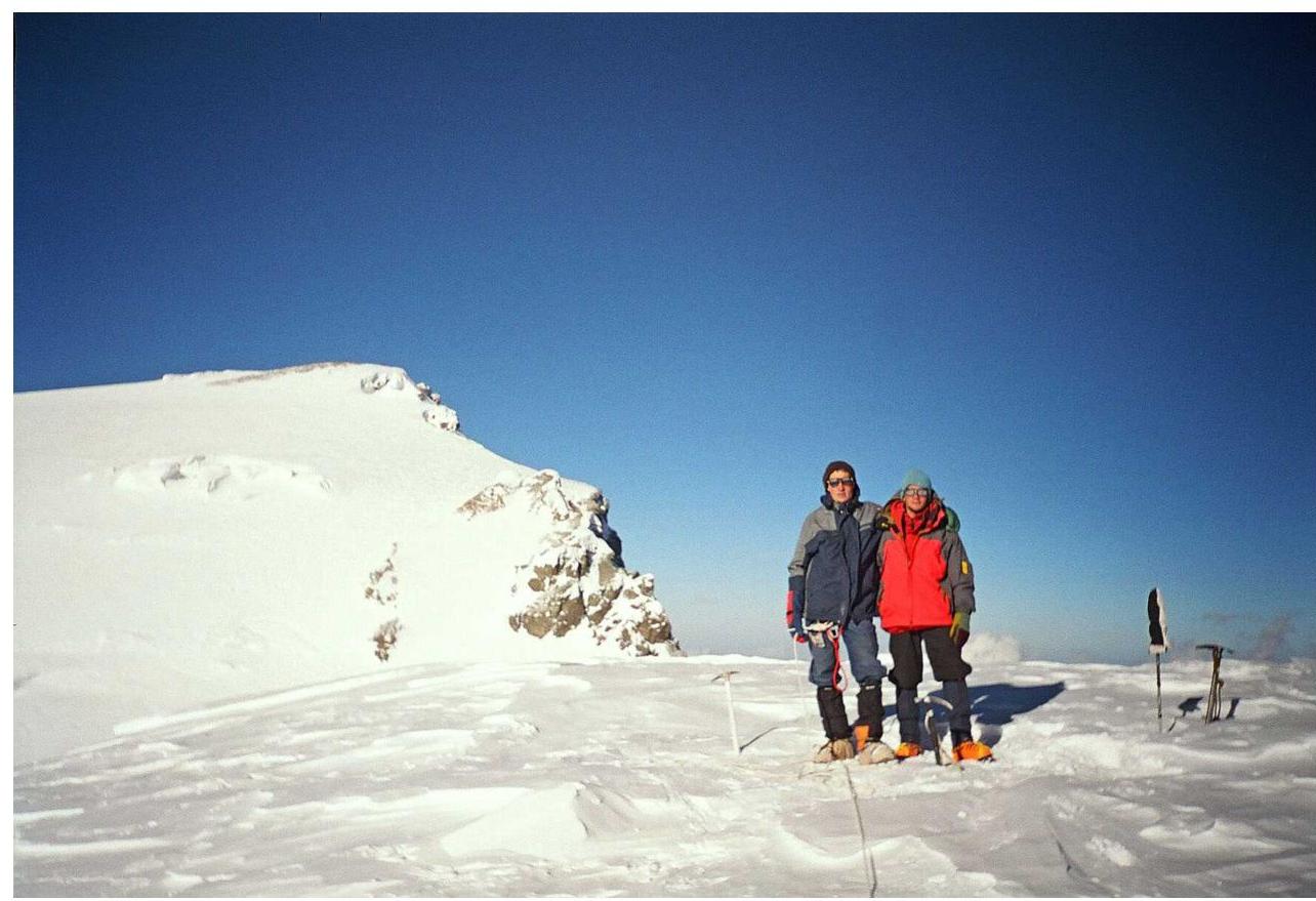 Fig.12. On Kalaxong peak (7277) (south shoulder of Muztag-Ata) (D. Chizhik is taking the photo).
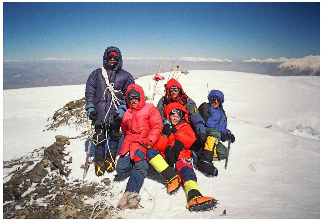 Fig.13. On Muztag-Ata summit (O. Yanchevsky is taking the photo).
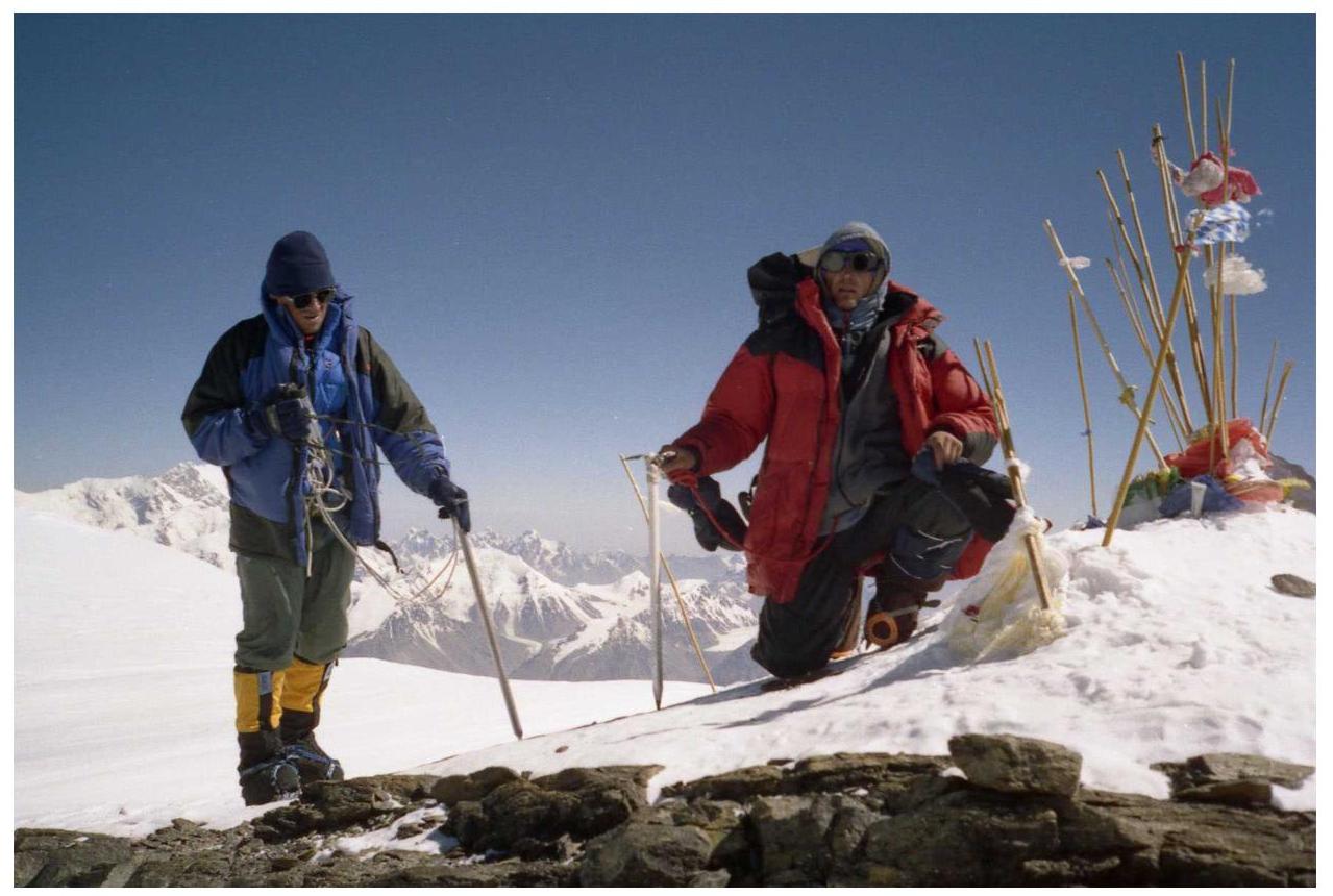 Fig.14. A. Lebedev and O. Yanchevsky on Muztag-Ata summit.
13. References
- A. Lebedev. Report on category 6B mountaineering trip to Chinese Pamir in 2005. MGTsTK library, report No. 6183. http://static.turclubmai.ru/papers/1124/ ↗
- A. Lebedev. Report on category 6B mountaineering trip to Chinese Pamir in 2011. MGTsTK library, report No. 7216. http://static.turclubmai.ru/papers/1994/ ↗
14. Ascent organization
- The ascent was part of the MAI Sports Complex mountaineering expedition to Chinese Pamir, which took place from July 25, 2005, to September 13, 2005.
- Photographs were taken by expedition members A. Lebedev, A. Mashenin, M. Tarakanovskaya, and O. Yanchevsky.
- The expedition was supported by: S7 Airlines, SITES-Center, and GlobalTel.
Comments
Sign in to leave a comment