1. Climbing Passport
-
Region: Kongur Muztagh Range (Kunlun). Gorge: Chimgan. Section number according to the 1999 classification table No. 11.3
-
Name of the summit: Pik Kyzylsel Route name: via the eastern ridge from the South Chimgan Glacier.
-
Proposed — 5A category of difficulty
-
Route type: Ice and snow
-
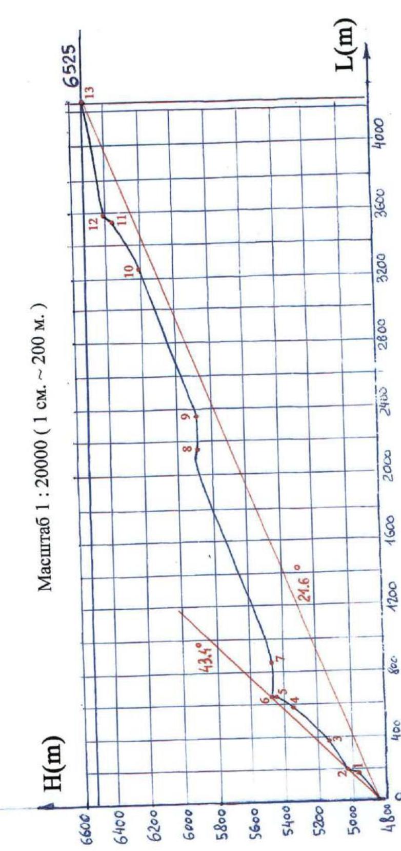
Height difference of the route: 1685 m (by altimeter).
Route length: 4712 m. Section length:
- 5th cat. diff. – 2 m
- 6th cat. diff. – 0 m. Average steepness:
- main part of the route — 43.4°
- entire route — 21.6°
- Hooks left on the route:
total — 0; including pitons — 0. Hooks used on the route:
- Ice screws — 12
- Rock anchors — 0. Stationary pitons — 0, including protection — 0. Removable pitons — 0, including protection — 0. Total protection used — 0
-
Team's travel hours: 19 hours, 3 days
-
Team leader: Lebedev Andrei Alexandrovich Team members: Gerov Ilya Valerievich, Malkov Boris Vladimirovich, Rykalov Petr Vladimirovich, Chkhetiani Otto Guramovich.
-
Coach: Lebedev Andrei Alexandrovich
-
Departure to the route: 10:00 August 22, 2000
Reached the summit: 16:40 August 24, 2000. Descent via the western ridge to the Karakol valley: 14:15 August 25, 2000
2. General Photograph of the Summit
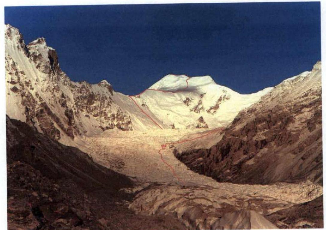 Fig.1. View of Pik Kyzylsel from the right moraine of the South Chimgan Glacier. Taken on August 19, 2000
3. Area Diagrams
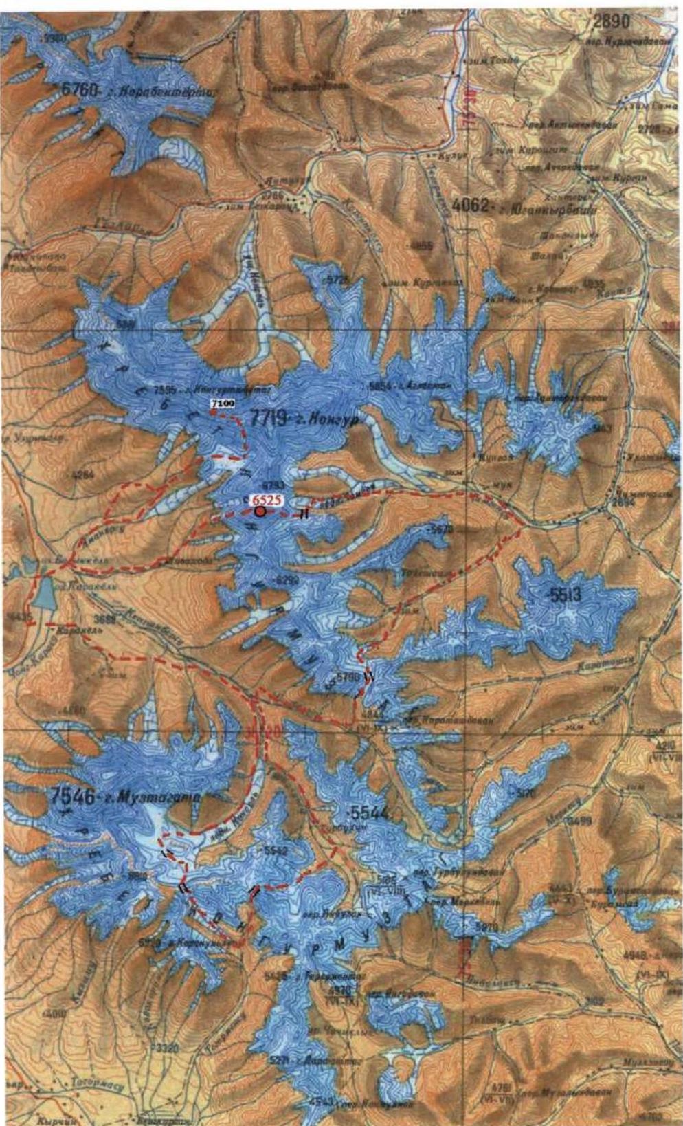
Diag.1. Kongur Muztagh Range and expedition route
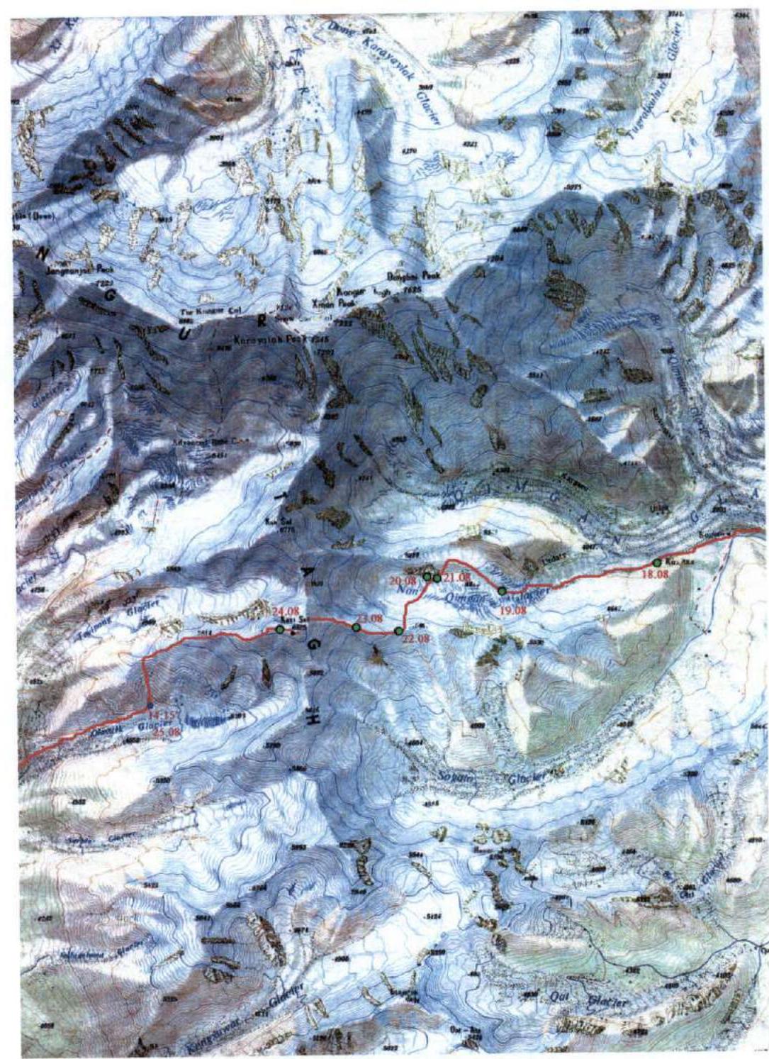
Diag.2. Expedition path through Pik Kyzylsel
4. Area Overview
Pik Kyzylsel is located at the watershed of the Kongur Muztagh Range, south of Kongur (7719). The range has a meridional direction in the area of this summit. North of the peak, beyond the saddle 6059, lies the summit of Koksel (6715). To the south, beyond the saddle 5608, stands the mountain of Sarakiakudji (6220). Pik Kyzylsel has extensive eastern and western ridges.
The western ridge descends into the Karakol lake valley. The Karakoram Highway passes by the lake, so numerous expeditions have already visited this area. According to data from the British Alpine Club database, the first ascent to Pik Kyzylsel was made via the western ridge in 1982. The category of difficulty is not available. Information about this expedition is not available in Russia. We were unable to find any information on subsequent ascents to this summit. It is possible that there were none.
The eastern ridge of Pik Kyzylsel descends into the Chimgansu river basin — a left tributary of the Khantereksu. The Chimgansu valley can be reached by caravan, following the Khantereksu valley upstream. Other paths lead here through mountain passes. For example, from Karakol lake, one can cross the caravan pass Karatash-Davan into the Karatashsu valley — a right tributary of Khantereksu. All the mentioned valleys are inhabited. There are excellent trails suitable for pack transport. We undertook a hiking program and were not tied to a caravan, so we were able to significantly shorten the path from Karakol lake to Chimgansu by crossing an unnamed pass (known to locals) that we named South Chat Pass (1B). In the Chimgansu valley, the trail rises to the right moraine of the South Chimgan Glacier.
We planned the ascent route via the eastern ridge using only a map, without descriptions or photographs. The path to the start of the route (to the upper plateau of the South Chimgan Glacier) is blocked by a powerful and difficult icefall. We spent one day (August 19, 2000) overcoming the lower stage of the icefall. Another day (August 20, 2000) was required to bypass the second stage of the icefall via the left tributary of the South Chimgan Glacier.
5. Technical Photographs of the Route
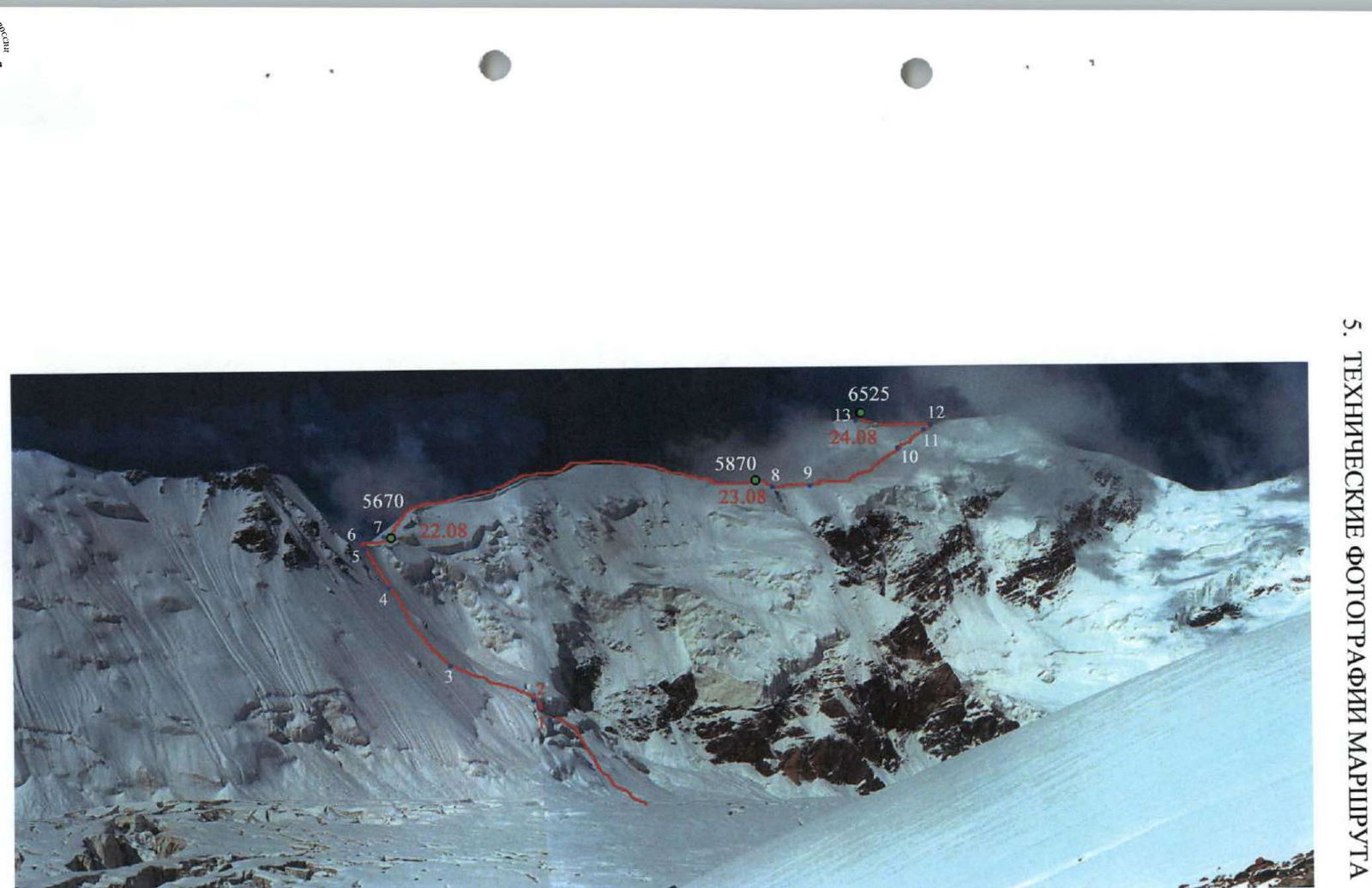 Fig.2. Eastern ridge of Pik Kyzylsel. Taken on August 20, 2000 from the ridge between the South Chimgan Glacier and its left tributary. Numbers indicate the ends of corresponding sections.
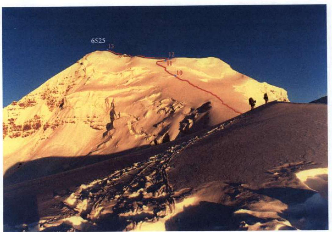 Fig.3. View from the eastern ridge on the final sections of the route. Taken on the morning of August 24, 2000
6. Route Sections Table
| № | Section Name | Start Height | End Height | Photo | Difficulty | Length (m) | Steepness (deg.) |
|---|---|---|---|---|---|---|---|
| 13 | Wide ice-snow ridge | 6400 | 6525 | 3 | 1 | 700 | 5–10, locally up to 25 |
| 12 | Ice slope | 6365 | 6400 | 3 | 3 | 50 | 45 |
| 11 | Snow-ice slope | 6200 | 6365 | 3 | 2 | 330 | 30 |
| 10 | Snow slope | 5870 | 6200 | 3 | 1 | 960 | 20 |
| 9 | Sharp snow ridge with cornices | 5870 | 5870 | 2 | 3 | 200 | 0–10 |
| 8 | Wide snow ridge with ups and downs | 5460 | 5870 | 2 | 2 | 1360 | 15–25, up to 40 on ups |
| 7 | Sharp snow ridge with cornices | 5460 | 5460 | 2 | 2 | 200 | 0–10 |
| 6 | Snow cornice | 5458 | 5460 | 2,4 | 5 | 2 | 90 |
| 5 | Steep ice slope | 5360 | 5458 | 2,4 | 4 | 120 | 50, upper part up to 60 |
| 4 | Ice-snow slope | 5140 | 5360 | 2 | 3 | 310 | 45 |
| 3 | Snow slope | 5012 | 5140 | 2 | 2 | 220 | 35–40 |
| 2 | Ice wall | 4980 | 5012 | 2 | 4 | 40 | 50, locally 60 |
| 1 | Snow slope | 4840 | 4980 | 2 | 2 | 220 | 40 |
7. Route Profile
8. Ascent Description (Excerpts from the Hiking Trip Report)
August 22. Departure at 8:20. 20 cm of snow fell overnight. The crust was slightly frozen, and we periodically sank through. The glacier plateau was heavily crevassed, and snow bridges over the crevasses were unreliable, making the transition through the plateau a significant problem in the second half of the day, see Fig. 2.
In two transitions, we approached the base of the northern wall of the eastern ridge of Pik Kyzylsel. The lower part of the wall features a large-block icefall, which from a distance appeared to be a serious obstacle. Above the icefall are short, inclined snowfields, and above that, a steep snow-ice slope crowned with cornices.
In the center of the icefall, we found a relatively easy passage. We mostly climbed simultaneously, only once setting up a rope belay (section 2, deep, loose snow, 50°, 15 m, then ice, initially 60°, 6 m, then 45–50°, 20 m).
Above the icefall, there were short sections with climbing and a filled-in crevasse. We traversed the icefall in two hours. From the snowfield (section 3), we transitioned to a not-so-prominent counterfort. The slope was initially 35–40°, becoming steeper at 45° (section 4). For 40 minutes, we climbed simultaneously on good steps. When the consequences of a potential fall became concerning, we switched to rope protection. We anchored the ropes:
- on ice axes,
- and on the upper part of the slope (section 5, snow-covered ice, 55–60°) — on ice screws, see Fig. 2, 4.
To reach the cornice, we set up 7 rope lengths. The last, 8th rope was thrown over a two-meter cornice (section 6), which we traversed with an ice axe. The ascent via the belay ropes took 4 hours and 30 minutes. The last two hours were spent in a snowstorm, so everyone got wet to some extent.
The ridge was sharp, with cornices on the north side. The south side featured a snow slope at 40°, see Fig. 2 and 4. Following the counterfort, we reached the ridge slightly east of the saddle 5460. After traversing 200 m along the ridge (section 7) and passing the saddle (no platform), we climbed to a convenient bivouac site in a hollow at 5470 m. The stars came out at night.
August 23, 2000. Departure at 9:20. Deep snow, with virtually no firn. We climbed for 4 hours until 13:35, constantly changing the lead (section 8). Along the way, we overcame several 50-meter sections with steepness up to 40°.
From the eastern ridge of Kyzylseля, there is a magnificent view of the Kashgar mountains. The alpine peaks of Agalistán are particularly striking. In the distance, the peaks of Karakoram are visible. Through the Kashgar Range, Muztag Ata is visible. However, the powerful southern slope of Kongur dominates the view, see Fig. 5. The weather gradually worsened. We stopped for lunch and, as a precaution, set up one tent.
After lunch, we were unable to depart. A strong wind began, and visibility was lost. We were on a flat shoulder in an excellent campsite. Ahead of us lay extensive and potentially avalanche-prone pre-summit snowfields. Therefore, we decided not to tempt fate and spent the night at the lunch spot. Altitude 5870 m.
August 24. Clear morning, visibility was stunning. It seemed that the peaks of the Tibetan plateau Aksai-Chin were visible to the southeast. Departure at 7:20. We descended slightly to the saddle. Here, the ridge was very sharp (section 9). We climbed in teams, one team at a time. Beyond the saddle, the ridge transitions into a pre-summit slope, see Fig. 3. Steepness was 20°, with loose and deep snow (section 10). It was very difficult to climb. The lead climber could only manage 30 steps before yielding to another team member. At 12:15, we reached a serac at 6200 m, see Fig. 3. Lunch. While preparing food, Ilya and Boris broke a trail over a 200-meter section.
We departed after lunch at 14:15. Steepness was 30°. Here, the snow was not as deep, and ice was occasionally encountered (section 11). The final section before reaching the northern ridge of Kyzylseля was an ice slope with a steepness of 45°, featuring narrow bergschrunds in the lower part and center (one rope length, section 12). We reached the northern ridge at 15:40. A strong southwest wind was blowing. Along the gentle and wide ridge, we climbed to the summit of Kyzylseля (6525 m) in 1 hour.
From the summit of Kyzylseля, we descended to a saddle before the western sub-summit in 10 minutes. Here, in a wind-sheltered hollow, we set up camp for the night. Altitude 6490 m. Some team members took citramon "as a precaution." Everyone slept well.
August 25. Clear morning. We began our descent via the western ridge at 9:20. There was significantly less snow here than on the eastern ridge. Apparently, the snow was blown to the opposite side of the mountain primarily by southwest winds. There was virtually no exposed ice.
We climbed simultaneously, occasionally using alternate protection, see Fig. 7. On a drop in the ridge, we set up one rope length (ice, 45°, with a narrow bergschrund below). Further, avoiding ice drops and cornices on the ridge, we moved alternately along the north and south sides. Sometimes we encountered:
- open and partially filled crevasses,
- exposed ice,
- small drops.
At 12:35, we reached a scree saddle at 5400 m. This was the first suitable spot to descend from the ridge, see Fig. 8. A descent to the south seemed more preferable. On the saddle, we removed our harnesses and had a snack.
A one-hour descent via small scree from the 5400 m saddle to the south led us to a glacier pocket. Here, at 4725 m, we stopped for lunch.
9. Photo Illustrations
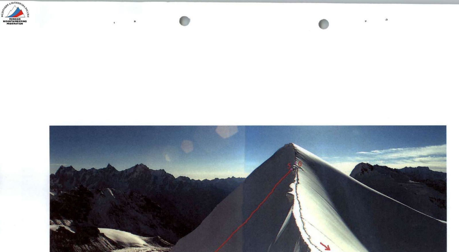 Fig.4. Ascent to the eastern ridge. Sections 5 and 6.
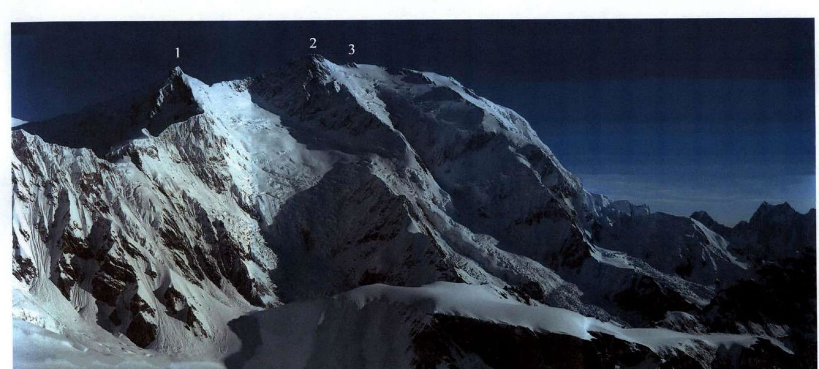 Fig.5. View from the eastern ridge of Kyzylseля towards the southern wall of Kongur. 1 — Nodal (7245), 2 — Main (7719), 3 — Eastern (7625) (Dongbei).
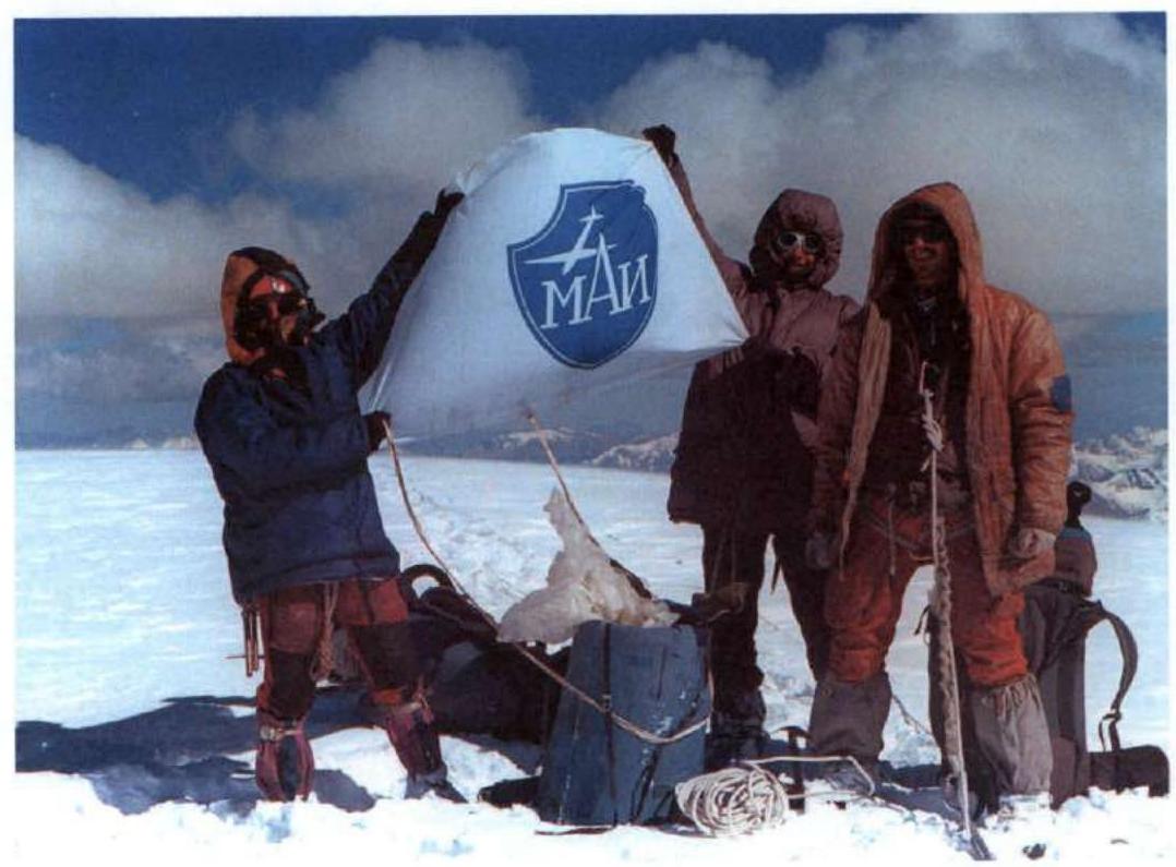 Fig.6. Team at the summit of Pik Kyzylsel. Evening of August 24, 2000
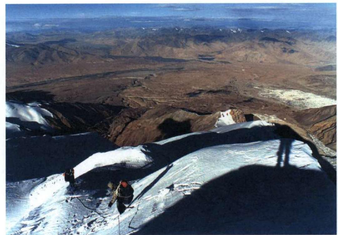 Fig.7. Descent from the summit via the western ridge. Morning of August 25, 2000
 Fig.8. Path of descent from Pik Kyzylsel via the western ridge. View from the southwest. 1 — p. Kongur (7719), 2 — p. Koksel (6715), 3 — p. Kyzylseля (6525). (Photo by an unknown author from the Internet)