
Open XIII CIS Championship (EAMA) in Alpinism 2004
EURO-ASIAN ALPINISM AND ROCK CLIMBING ASSOCIATION
11.3.6A
High-Altitude Technical Class
Report
on the ascent of Kongur Tagh (7719 m)
at the Open XIII CIS Championship (EAMA) in Alpinism 2004
Team of the Moscow Federation of Alpinism and Rock Climbing
Leader: Vyacheslav V. Odokhovsky
Expedition Leader: Yuri V. Khokhlov
Coach: Yuri V. Khokhlov
Senior Coach: Yuri P. Tinin
Moscow 2004
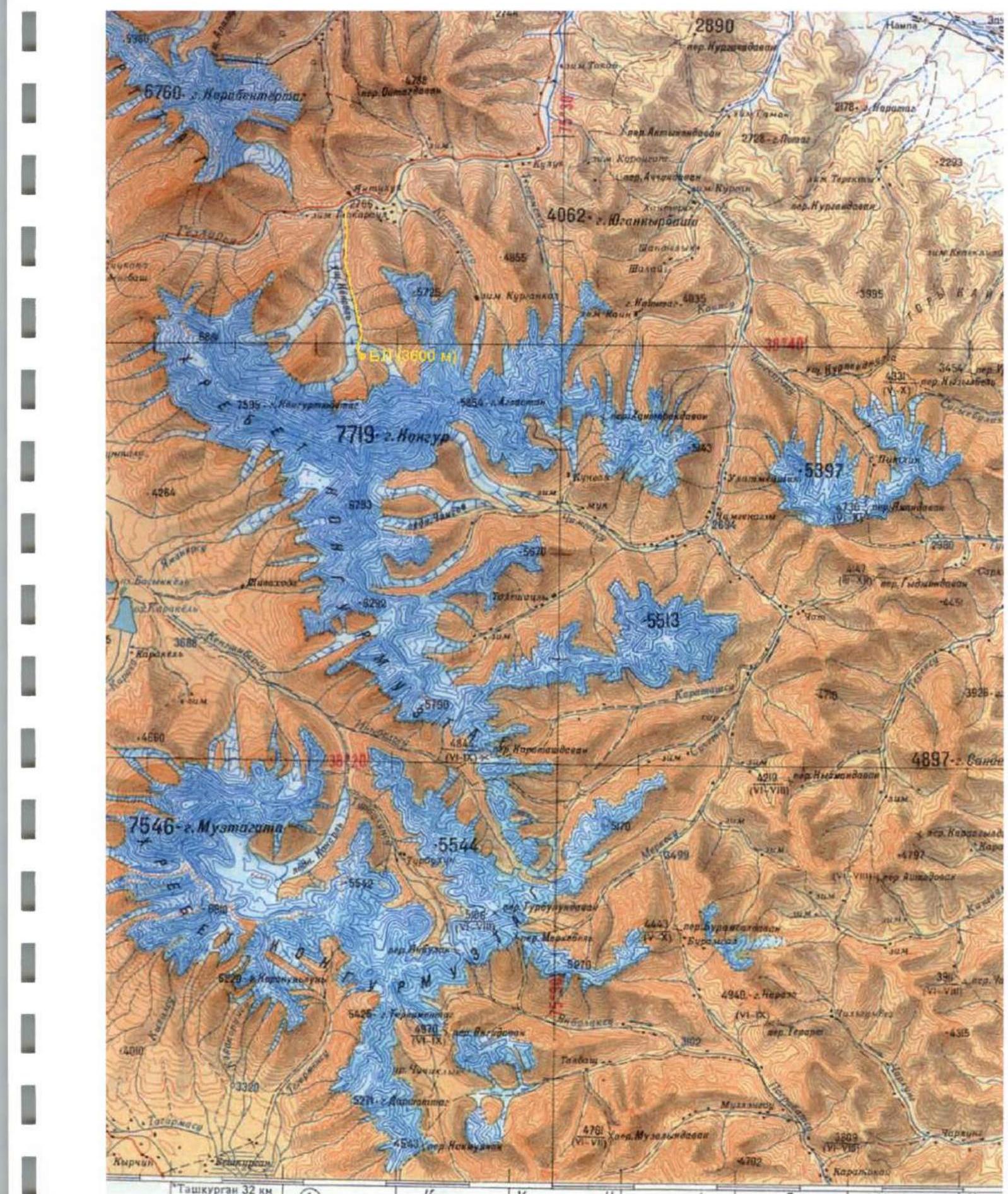
- Region, valley, section number according to the classification table (2001) – 11.3 Mountain region: Kun-Lun (China, Xinjiang Uyghur Autonomous Region) Ridge: Kongurmuztagh.
- Name of the peak: Kongur Tagh (7719 m), route name: From the North, via the C-3 buttress of the wall (“Moscow Express”)
- Proposed category – 6A, first ascent
- Route character: combined
- Route height difference: 4100 m (by altimeter and GPS) Route length: 7310 m. Length of sections: V category – 510 m, VI category – 80 m. Average slope: main part of the route – 42°, including: section 4900–5200 – 50°, section 5500–5700 – 45°, section 6400–6800 – 53°, entire route – 34°.
- Pitons left on the route: total 15, including 0 bolts Pitons used on the route: rock – 20, ice – 83, including 8 for ITO, snow – 14. Bolts (stationary, removable) were not used.
- Team climbing hours: 64 hours, 7 days
- Leader: Vyacheslav V. Odokhovsky, 1st sports category Participants: Vladislav E. Kagan, 1st sports category; Viktor E. Kulbachenko, Master of Sports of Russia (ZMS) Vladimir G. Legkikh, Candidate for Master of Sports (CMS) Andrey P. Medvedev, 1st sports category; Andrey E. Petrov, CMS Expedition Leader: Yuri V. Khokhlov, Master of Sports (MS)
- Coach: Yuri V. Khokhlov, MS Senior Coach: Yuri P. Tinin, CMS
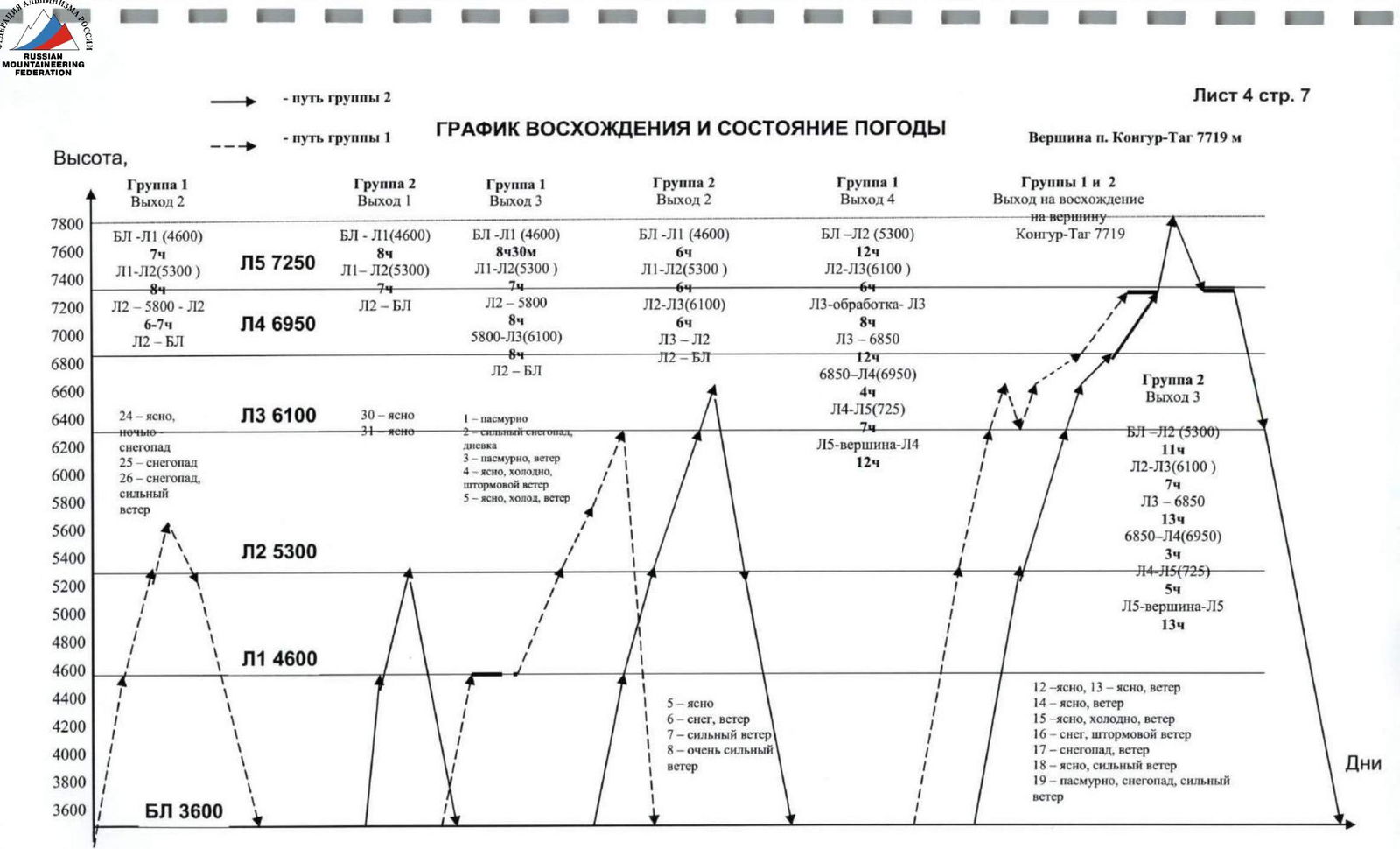
- Departure for the route: Khokhlov) – 8:00 (Beijing time), August 12, 2004; 2nd group – 8:00 (Beijing time), August 14, 2004. Summit: 15:00 (Beijing time), August 18, 2004 – V. Kulbachenko; 17:00 (Beijing time), August 19, 2004 – 5 people. Return to Base Camp: 22:00 (Beijing time), August 22, 2004.
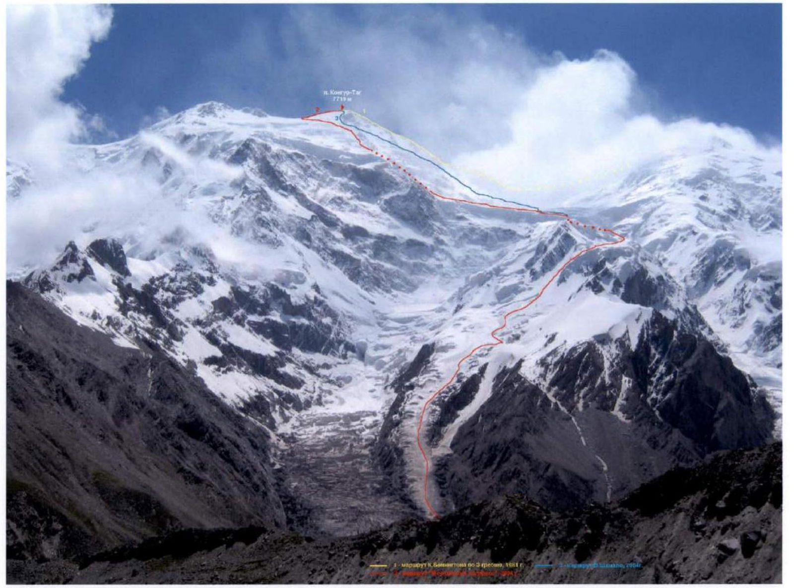
Photo #1 (V. Odokhovsky), July 2004, from Karayalak glacier 3550 m.
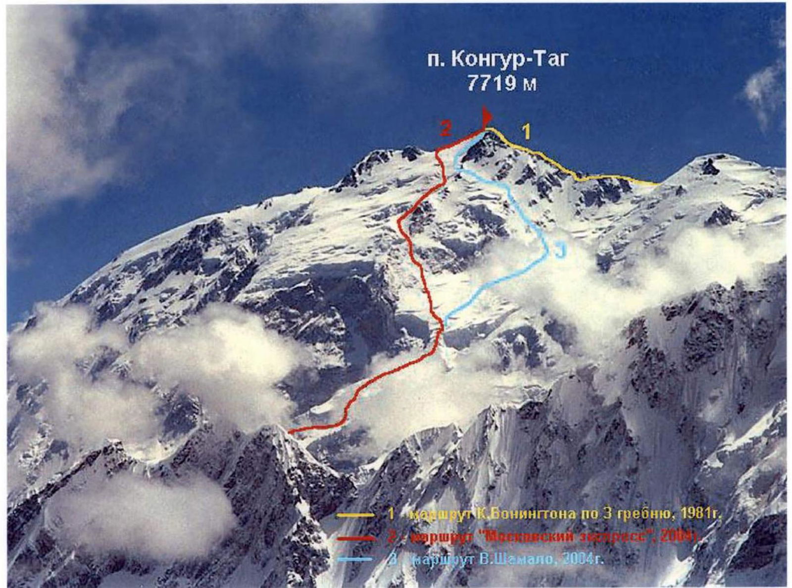
Photo #2 (A. Chkhetiani), August 2003, from the NE ridge of Aklangamh, 5400 m (expedition of MAI SC led by A. Lebedev)

Photo #3 (V. Odokhovsky), August 2002, from the N ridge of Kongur Tagh, 5600 m

Photo #4 (P. Rykalov), August 2002, from the summit of Aklangamh, 6995 m (expedition of MAI SC led by A. Lebedev)
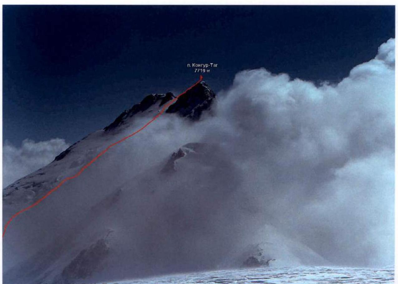
Photo #5 (A. Lebedev), August 2000, from the E ridge of Yamandjar, 7100 m (expedition of MAI SC led by A. Lebedev)
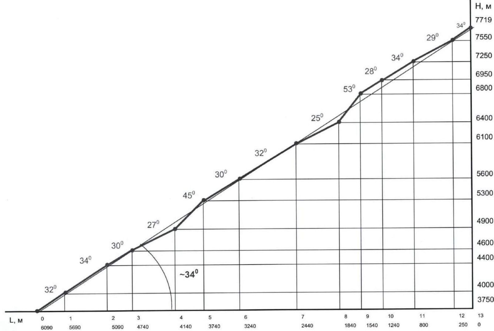

Photo #6 (A. Medvedev), August 2004, slope above the moraine of Dong Karayalak glacier, 4000 m.
Ascent object map
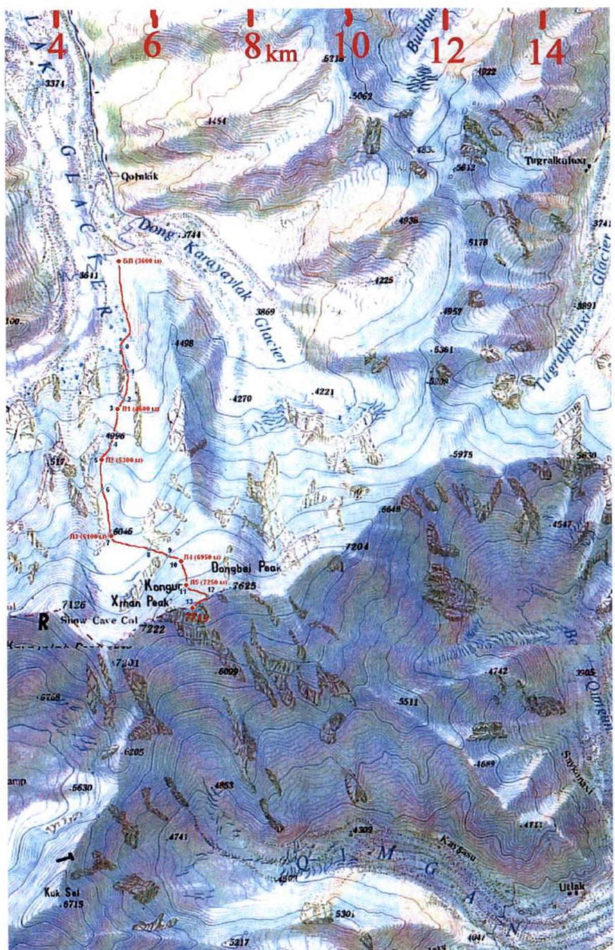
Ascent object map with route
Brief overview of the ascent area
Kongur Tagh (7719 m) is located in China, in the Kongurmuztagh ridge, the highest point of the ridge and the Kun-Lun region. The eastern edge of the Pamir plateau is bordered by a chain of high mountain ridges. They rise like a huge wall above the oases of Kashgar and the Takla-Makan desert. This chain starts from the eastern outskirts of the Trans-Alai ridge and, turning to the southeast, turns into the King-Tau ridge with the highest mountain Chakragil 6670 m (some maps show the name Karabektortagh). The Kashgar ridge is separated from the King-Tau mountains by the Gez river valley. The upper reaches of the Tashkurgandar'ya separate the Kashgar ridge to the east from the Tashkurgan and Chon-Kyr ridges, which continue this mountain chain until it connects with the Western Kun-Lun.
The highest points of the Kashgar ridge are the peaks of Muztagh Ata (7546 m) and Kongur Tagh (7719 m), lying at the intersection of the axial lines of many ridges. They are referred to as both the Eastern Pamir and the Western Kun-Lun. The total glaciation area of the ridge is 2258 km². There are dozens of glaciers on Kongur, with the largest ones reaching 15 km in length.
The foot of the ridges to the west and southwest are located at altitudes of 3800–4000 m, the slopes have relatively gentle outlines, although they are very steep. The glacier tongues are located at altitudes of around 4500 m. To the east and northeast, the Kongur and Muztagh Ata massifs drop off with more than three-kilometer-high rock-ice walls. The Kongur massif is a whole mountain country, rarely visited due to the lack of roads. The valleys to the east are cut deeper than to the west, and the rivers flow in canyons. On the northern slopes of the ridges, some forests of fir, juniper, and Tien Shan spruce have been preserved.
The main population of the Kashgar mountains are Kyrgyz.
The approach from the city of Kashgar (1300 m), Xinjiang Uyghur Autonomous Region, PRC – 3–4 hours to the border post Gez (2300 m). The road has been improved, so there are no longer hour-long delays. The road is being improved, but it is often closed due to landslides, washouts, and construction work, causing hour-long delays. From the border post, across the bridge over the Gez Dar'ya river, we enter the village of Shang Gez. Overnight stay is possible:
- in a house by the road,
- or on the stadium in the village at the top.
Further to the Base Camp (BC) for the ascent of Kongur Tagh from the north along the Karayalak glacier (on its right side) – a camel or donkey caravan takes 7–8 hours. BC (3600 m) is located on the grass at the foot of the northern ridge of Kongur Tagh next to a Kyrgyz nomad camp. There is a stream (dries up in August) and springs on the slope.
The approach to the start of the route from the North, via the C-3 buttress of the wall from BC along the valley and the glacier – 30 minutes on foot. Descent from the moraine to the torn glacier, which is crossed to the right, and exit under the wall. Climb under the wall along the stream bed on the glacier upwards through crevasses to a narrow neck between the icefall to the left and the wall to the right – 1 hour. Path bypassing the fractures. The route begins:
- Ice wall 10 m.
- Traverse along the ice wall with an overhang (ITO), 60 m of rope to a depression.
Here is the beginning of a huge ice slope, which rises along the icefall. From BC, the total path length is 2–3 km.
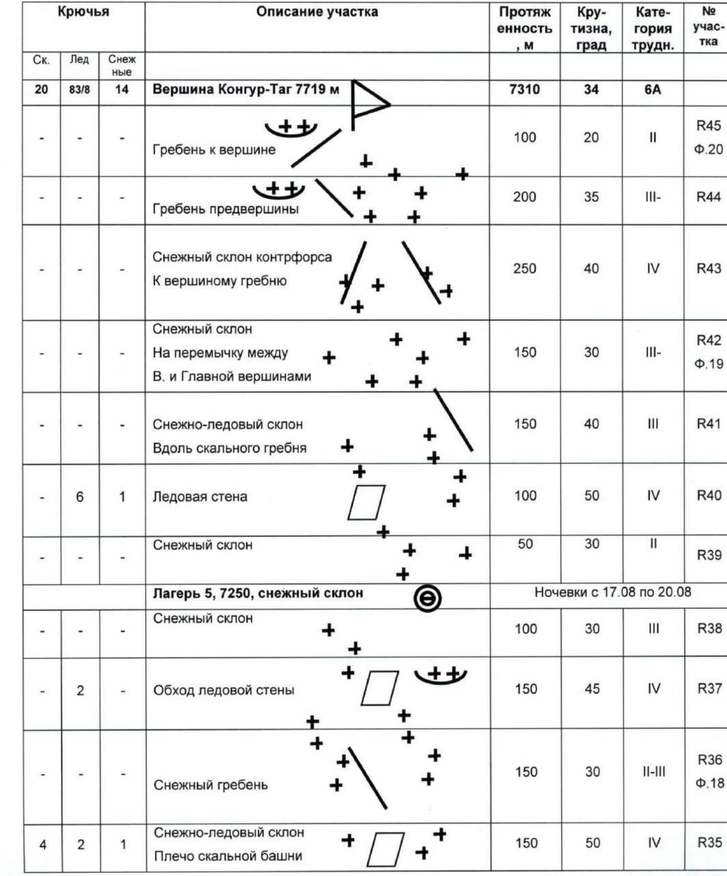
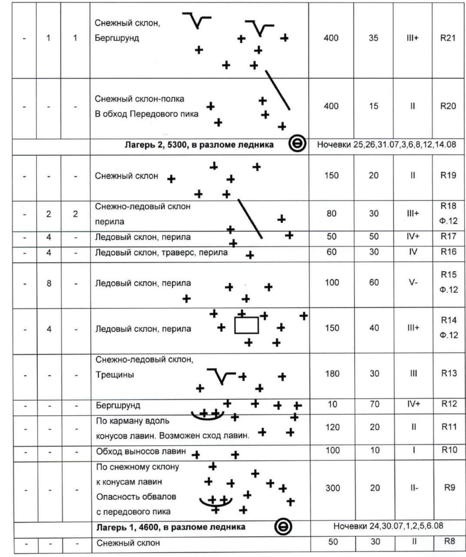
Route scheme in UIAA symbols
| Pitons | Description of section | Length, m | Steepness, deg | Category of difficulty | Section # |
|---|---|---|---|---|---|
| Rock | Ice | Snow | |||
| 20 | 83/8 | 14 | Kongur Tagh 7719 m summit | 7310 | 34 |
| – | – | – | Ridge to the summit | 100 | 20 |
| – | – | – | Sub-summit ridge | 200 | 35 |
| – | – | – | Snow slope of the buttress to the summit ridge | 250 | 40 |
| – | – | – | Snow slope on the saddle between the sub-summit and the Main summit | 150 | 30 |
| – | – | – | Snow-ice slope along the rocky ridge | 150 | 40 |
| – | 6 | 1 | Ice wall | 100 | 50 |
| – | – | – | Snow slope | 50 | 30 |
| Camp 5, 7250 m, snow slope | Overnight stays August 17–20 | ||||
| – | – | – | Snow slope | 100 | 30 |
| – | 2 | – | Bypass of the ice wall | 150 | 45 |
| – | – | – | Snow ridge | 150 | 30 |
| 4 | 2 | 1 | Snow-ice slope, Shoulder of the rocky tower | 150 | 50 |
| Camp 4, 6950 m, in the glacier crevasse | Overnight stays August 16, 18 | ||||
| – | – | – | Snow-ice slope | 100 | 40 |
| – | – | – | Snow-ice slope | 150 | 30 |
| – | 2 | – | Bypass of the ice wall, 6850 m, intermediate camp | 50 | 45 |
| – | 4 | 2 | Snow-ice slope | 150 | 40 |
| 12 | 2 | 1 | Rocky zone, rope railing. Snow-covered, icy rocks | 170 | 65 |
| 4 | 2 | – | Ice slope, traverse to rocks, rope railing | 30 | 35 |
| – | 4 | – | Ice slope, rope railing | 100 | 45 |
| – | 8 | – | Snow-ice slope, rope railing | 180 | 40 |
| – | – | – | Snow plateau, path to the “triangle” 6400 m | 500 | 15 |
| Camp 3, 6050 m, in the glacier crevasse | Overnight stays August 5, 7, 13, 14, 15, and 21 | ||||
| – | – | 2 | Snow-ice walls | 40 | 40 |
| – | 8/4 | 3 | Ice wall | 50 | 85 |
| – | – | 1 | Snow walls. Climb to the grotto | 200 | 40 |
| – | – | – | Snow ridge | 200 | 20 |
| – | 1 | 1 | Snow slope, Bergschrund | 400 | 35 |
| – | – | – | Snow slope-shelf. Bypass of the Forepeak | 400 | 15 |
| Camp 2, 5300 m, in the glacier crevasse | Overnight stays July 25, 26, 31, and August 3, 6, 8, 12, 14 | ||||
| – | – | – | Snow slope | 150 | 20 |
| – | 2 | 2 | Snow-ice slope, rope railing | 80 | 30 |
| – | 4 | – | Ice slope, rope railing | 50 | 50 |
| – | 4 | – | Ice slope, traverse, rope railing | 60 | 30 |
| – | 8 | – | Ice slope, rope railing | 100 | 60 |
| – | 4 | – | Ice slope, rope railing | 150 | 40 |
| – | – | – | Snow-ice slope, Crevasses | 180 | 30 |
| – | – | – | Bergschrund | 10 | 70 |
| – | – | – | Along the couloir with avalanche cones. Avalanche risk. | 120 | 20 |
| – | – | – | Bypass of avalanche outwashes | 100 | 10 |
| – | – | – | Snow slope to avalanche cones | 300 | 20 |
| – | – | – | Danger of rockfall from the Forepeak | ||
| Camp 1, 4600 m, in the glacier crevasse | Overnight stays July 24, 30, and August 1, 2, 5, 6 | ||||
| – | – | – | Snow slope | 50 | 30 |
| – | – | – | Snow slopes, Crevasses | 300 | 15 |
| – | – | – | Snow-ice ridge, rope railing | 150 | 30–40 |
| – | 2 | – | Ice slope, rope railing | 40 | 55 |
| – | – | – | Snow-ice valley, Crevasses | 200 | 30 |
| – | 4 | – | To 4200 m – ice slope, possible rockfall. | 650 | 35–40 |
| – | – | – | Avalanche cone – possible avalanche. | 100 | 20 |
| – | 8/4 | – | “Neck” – climb via the ice wall, traverse of the vertical ice wall, rope railing | 60 | 40 |
| – | – | – | Climb along the glacier to the “neck” – possible rockfall. | 200 | 20 |
| – | – | – | August 14, 2004 – Base Camp – C1–C2: 3550–4600–5300 | ||
| 20 | 83/8 | 14 | 7310 | 34 |
 Route scheme in UIAA symbols (continued)
 Route scheme in UIAA symbols (continued)
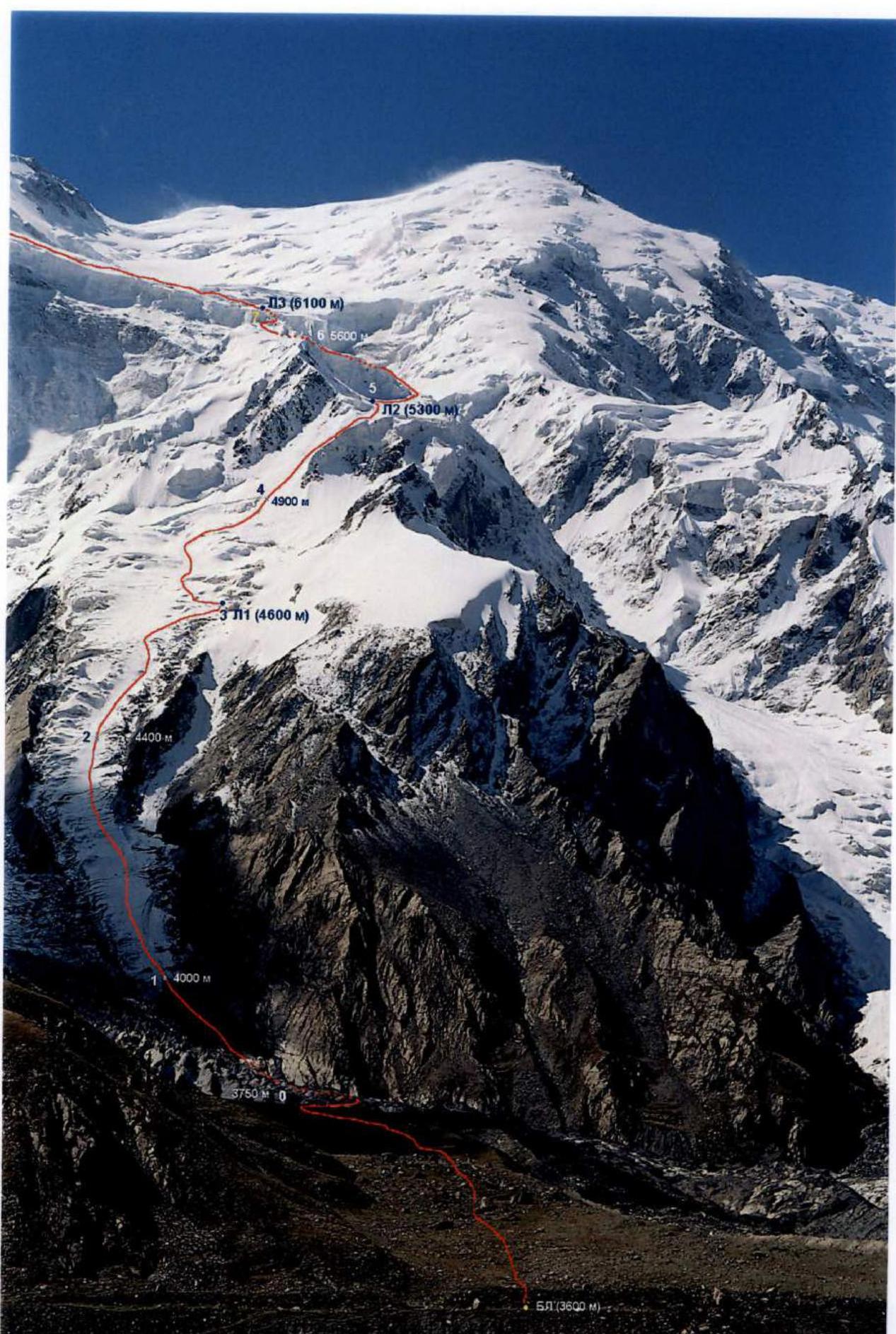
Photo #7 (A. Chkhetiani), August 2003, moraine of Dong Karayalak glacier, 3550 m (expedition of MAI SC led by A. Lebedev)
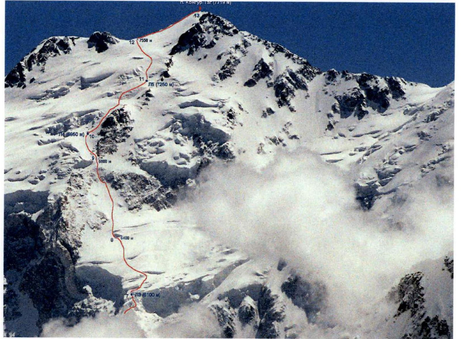
Photo #8 (A. Chkhetiani) – August 2003, from the NE ridge of Aklangamh, 5400 m (expedition of MAI SC led by A. Lebedev)
Notes from control points and the summit
Since the summit is a snow ridge without rock outcrops, a note from previous climbers is absent. The group left two bamboo poles with a note about the ascent to Kongur Tagh (7719 m) from the north via a new route on the summit.
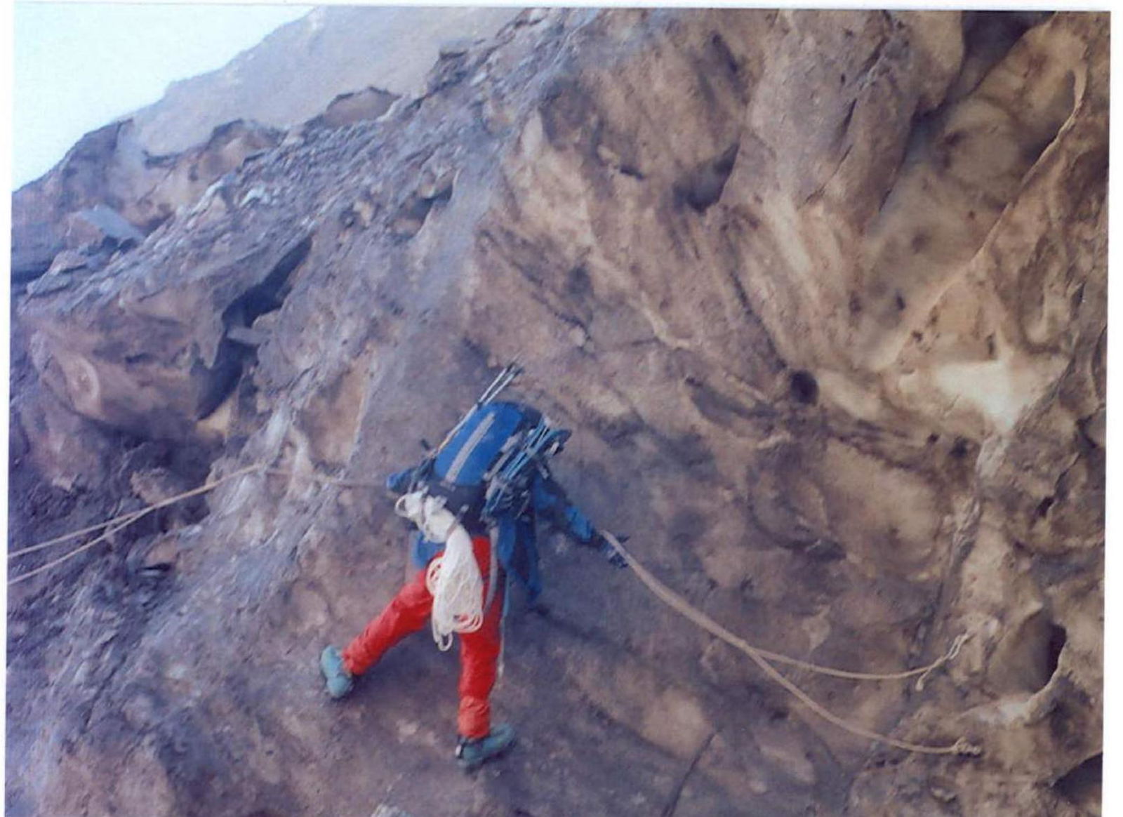
Photo #10 (A. Medvedev) – August 2004, section R1, 3800 m

Photo #11 (A. Medvedev) – August 2004, section R2–R3, 3800–4000 m
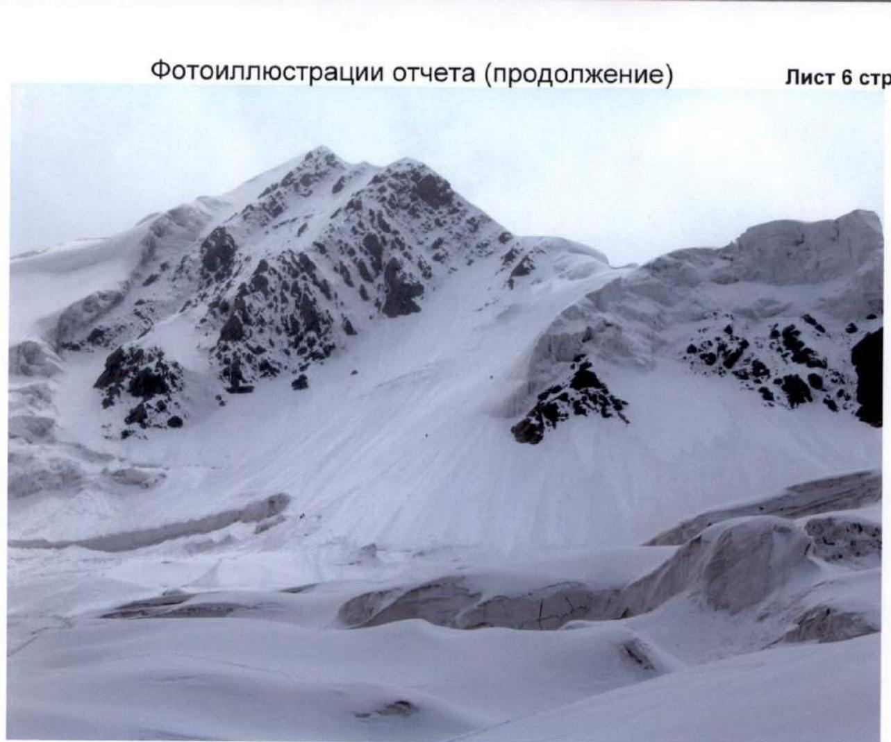
Photo #12 (V. Odokhovsky) August 2004, section R14–R18, 4900–5200 m
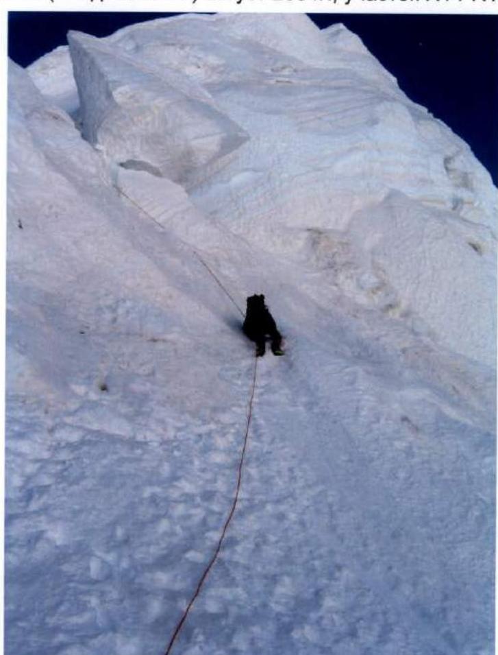
Photo #13 (V. Odokhovsky) August 2004, section R24, 5950 m
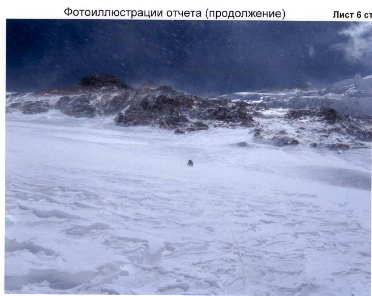
Photo #14 (V. Odokhovsky) August 2004, section R27, 6500 m

Photo #15 (V. Odokhovsky) August 2004, section R27–R31, 6400–6800 m

Photo #16 (V. Kulbachenko) August 2004, section R29, 4600 m
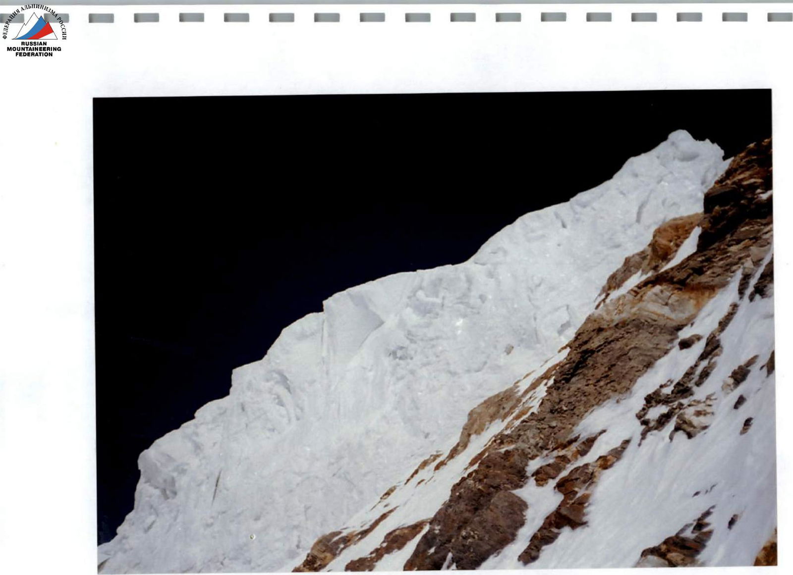
Photo #17 (V. Kulbachenko) August 2004, section R30, 4650 m
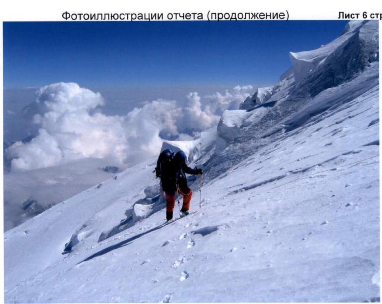
Photo #18 (V. Odokhovsky) August 2004, section R36, 7100 m
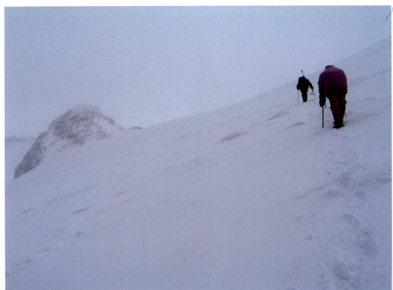
Photo #19 (V. Odokhovsky) August 2004, section R42, 7400 m

Photo #20 (V. Odokhovsky) August 2004, section R45, 7700 m
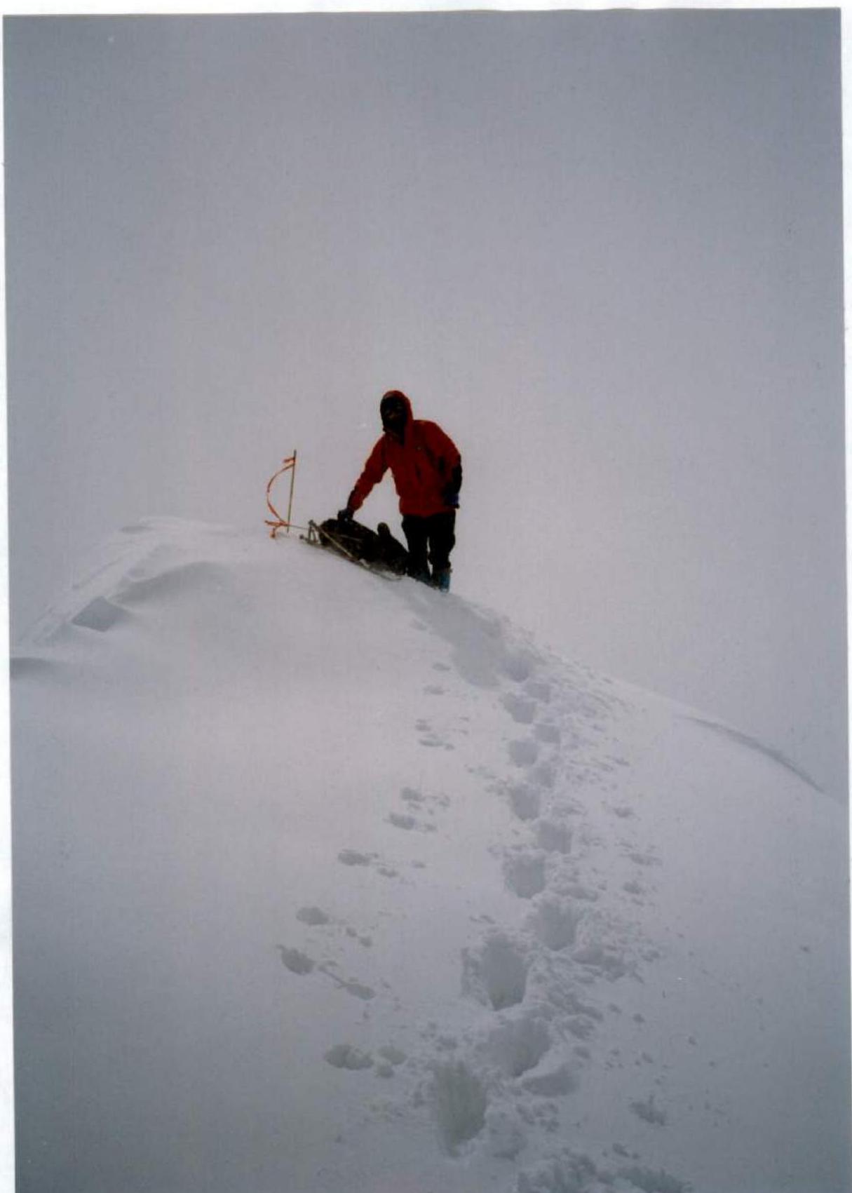
Photo #21 (A. Medvedev) August 2004, on the summit of Kongur Tagh, 7719 m
Comments
Sign in to leave a comment