
Passport
- Class: High-altitude technical
- Eastern Pamir, Kashgar Mountains (western China)
- Peak Muztag-Ata (7546 m) via the western ridge, cat. diff. 5A
- Proposed cat. diff. 5B (possibly the 3rd ascent by a purely Russian team)
- Height difference — 3000 m, length — 9000 m, average slope — 20°
- Used pitons, 6 ice screws
- Climbing days — 3.5–5 (including descent to base camp)
- Overnights:
- 1st in tents on a rocky platform
- 2nd and 3rd in a tent on a snow-ice slope
- Captain — Lavrenenko V. V., MS
Team members:
- Odokhovsky V. V., 1st sports category
- Petrov A. E., MS
- Khokhlov Yu. V., MS
- Khlyustikov I. N., CMS
- Coach — Khokhlov Yu. V., MS
- Approach to the route on August 29, 1997
- Organization: FaiS Moscow
Summit on September 1 at 15:00, return on September 2
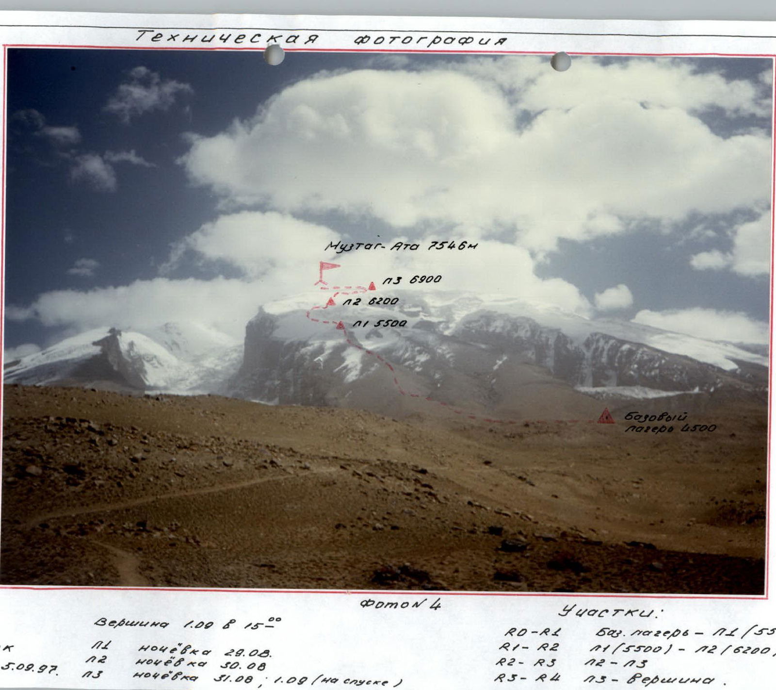
Technical Photograph
 Muztag-Ata (7546 m)
R3 (6900 m)
R2 (6200 m)
R1 (5500 m)
Base camp (4500 m)
Muztag-Ata (7546 m)
R3 (6900 m)
R2 (6200 m)
R1 (5500 m)
Base camp (4500 m)
Photo 4
Sections
- R0–R1: Base camp – R1 (5500 m)
- R1–R2: R1 (5500 m) – R2 (6200 m)
- R2–R3: R2 – R3
- R3–R4: R3 – Summit
4–5 km. Camera — Kodak Date taken: September 5, 1997
Summit on September 1 at 8:15
- R1 overnight stay on August 29
- R2 overnight stay on August 30
- R3 overnight stay on August 31; September 1 (on descent)
NX N-PyT KONANZOI (August 28, 1999) Pomo N'3 Bué cas KapaKyaO HO HO20-BocTOX
Hand-drawn route profile
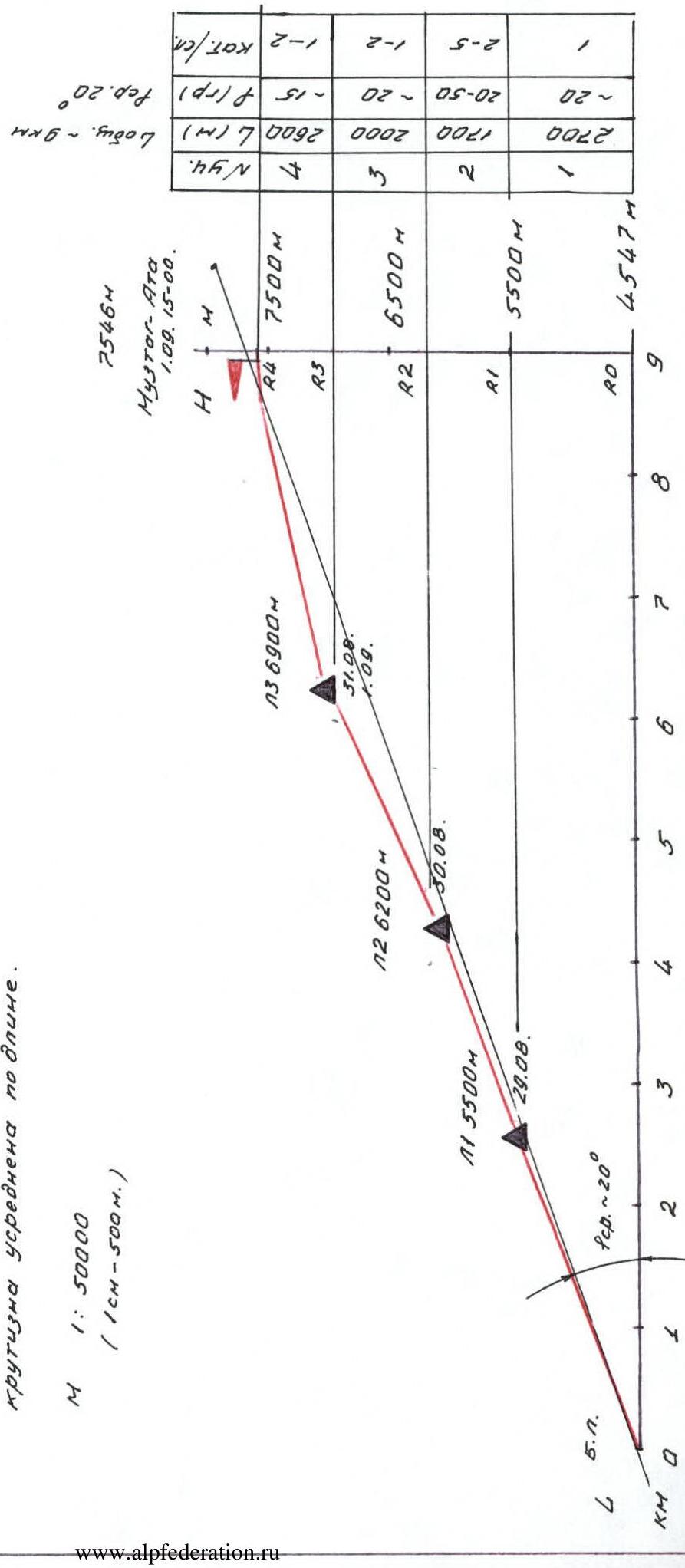
Hand-drawn Route Profile
Note:
- The profile is slightly unfolded.
- Due to the large length of the sections, their steepness is averaged over the length. M 1:50,000 (1 cm = 500 m).
Muztag-Ata (7546 m), September 1 at 15:00.
| Section | L m | Average slope | k/tr. |
|---|---|---|---|
| R4 | approx. 2600 | ~15° | 1:2 |
| R3 | approx. 2000 | 15–20° | 1:2 |
| R2 | approx. 1700 | ~20° | 2:5 |
| R1 | about 2700 | ~20° | 1 |
| R0 |
L total 9000 m Average slope 20°
P.S. Number of climbing hours — see "Ascent Schedule"
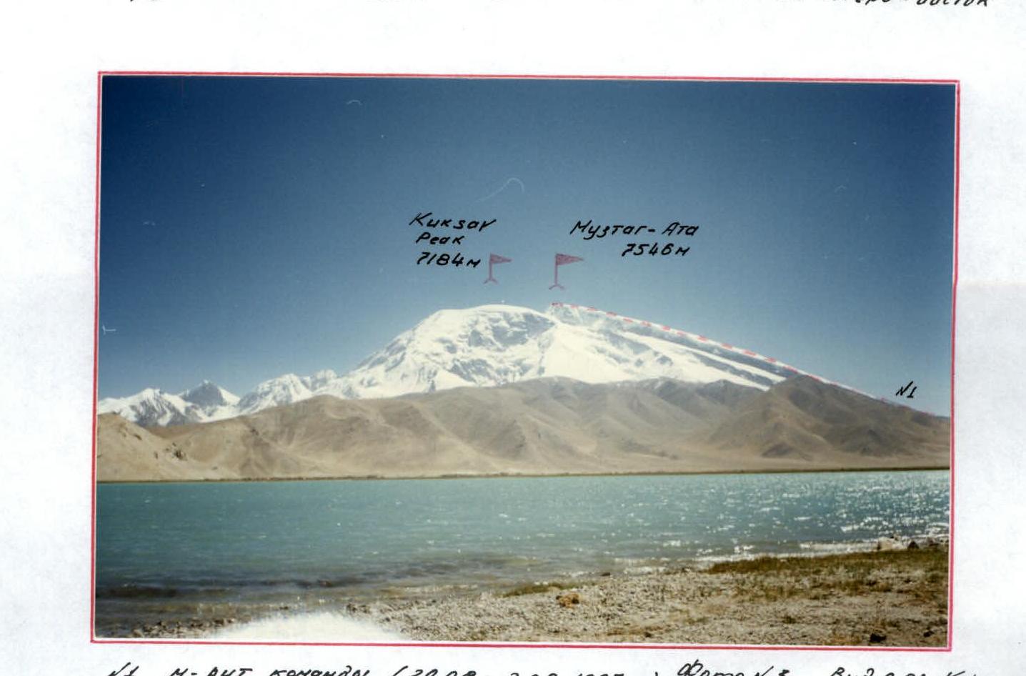
Panoramic Photograph of the Area
Kungur-Tyube (7530 m) 7229 m 7126 m Kongur-Tag (7719 m) Kuk-Sel (6715 m) Kezi-Sel (6525 m) 5780 m
N2 route by Kuzmin and Beletsky, 1956. Photo N2. From Kara-Kul lake to the northeast. N3 route by Bonington, 1981. L=25 km.
Kuksar-Pik (7184 m) Muztag-Ata (7546 m)
N1 route by the team (August 29 – September 2, 1997). Photo N3. View from Kara-Kul lake to the southeast. L=20 km. Date taken: September 10, 1997
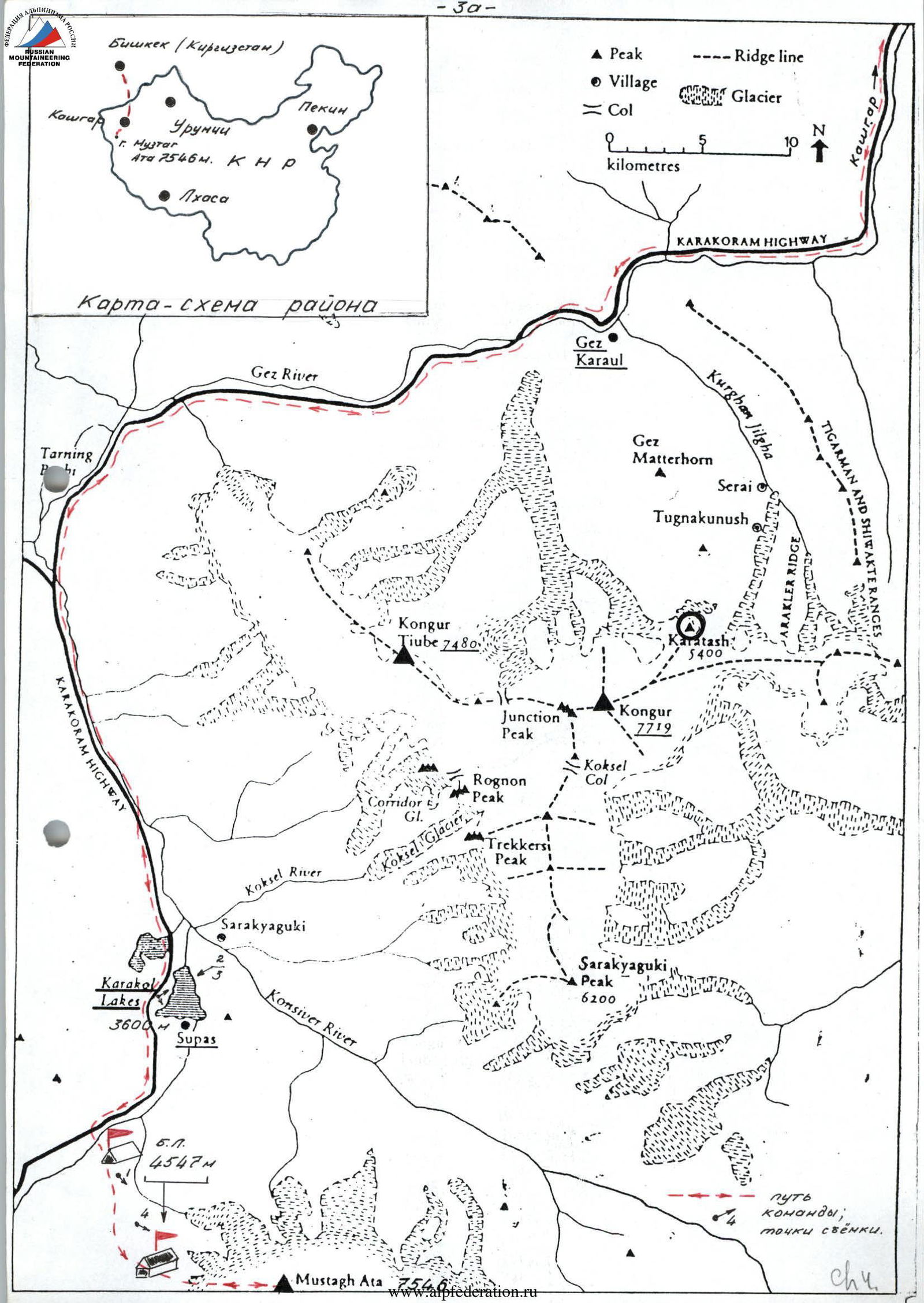
Brief Overview of the Climbing Area
The object of our team's ascent — the summit of Muztag-Ata (7546 m) is located in the range on the eastern edge of the Pamir on the territory of western China.
The eastern edge of the Pamir highland, the Kashgar Mountains, is a giant icy barrier separating the Pamir from the greatest desert of Central Asia — Takla-Makan. The Pamir plateau here extends to the east, and this enormous eastern foothold of the "Roof of the World" is strictly outlined from the northeast by the chain of the Kongur mountain system, from the east — by Muztag-Ata. South of the Pamir, it turns into a 200-kilometer-wide strip of desert plateaus, which is framed to the south by the chain of giants of the Karakoram, and to the north — by the Takla-Makan desert. This strip connects the plateaus of the Pamir and Tibet. In the ranges of Muztag-Ata and Kongur, there are three highest peaks of the entire Pamir: Kongur-Tag (Kongur-1) with a height of 7719 m, Kongur-Tyube-Tag (Kongur-2) with a height of 7595 m, and the main peak of Muztag-Ata with a height of 7546 m.
The foothills of the ranges to the west and southwest lie at altitudes of 3800–4000 m; the slopes have fairly calm outlines, although they are quite steep near most of the Kongur peaks. The tongues of the glaciers are located at altitudes of about 4500 m.
To the east and northeast, the Kongur and Muztag-Ata ranges drop off with almost sheer 3-kilometer walls, with exposed rocks and icy drop-offs in places. The glaciers here have elevations of around 3500–4000 m, and 8–12 km from the glaciers, the elevation drops to 2600–2200 m.
The first ascent of Muztag-Ata was made in 1956 along the most southerly of the western ridges. At that time, a joint Soviet-Chinese expedition led by Beletsky E. A. and Kuzmin K. K. worked here. Then, 31 climbers reached the summit:
- 19 Russians
- 12 Chinese
Before that, the peak was unsuccessfully attempted by Swedish traveler Sven Hedin in 1894 and British climbers Shipton E. and Tilman H. in 1947. After 1956, the summit of Muztag-Ata was climbed in 1959 (33 participants) and in 1961. Until 1980, the area was "closed," and only in the early 1980s did interest in it re-emerge.
Currently, the route to Muztag-Ata (so far the only one) is quite frequently visited. Among domestic climbers, it is worth noting the Tomsk climbers who made the ascent in September 1996. In July–August of the same year, two international expeditions (led by Ershov A.) worked on the slopes of Muztag-Ata.
To reach the base camp (4500 m), one can follow this route:
- Fly from Moscow to Bishkek.
- Then travel by car to the Kyrgyz-Chinese border via the route: Bishkek – Rybachye (Lake Issyk-Kul) – Naryn – Torugart Pass.
- Then, the route continues through China: from Torugart Pass — Kashgar — Gez — Kara-Kul lake (3600 m).
- Travel is by car on a well-asphalted road leading towards Tashkurgan and further to Islamabad.
- Another 15 km along the road to the Subash village.
- From here, travel is by a good trail (about 10 km) to the base camp under Muztag-Ata (4500 m).
- The transportation of expedition cargo is carried out with the help of a camel caravan.
With a good plan, the travel time to the base camp from Bishkek takes 4 days (1.5 days in Kyrgyzstan, 2.5 days in China).
The base camp is a tent city on a fairly large clearing (similar to the clearing at Lake Moskvina). The approach to the route takes 10–15 minutes.
Expedition Schedule to Muztag-Ata
- August 16 — departure from Moscow to Bishkek
- August 18 — arrival in Kashgar (China)
- August 19 — transfer to Kara-Kul lake (3600 m)
- August 20 — transition to base camp (4500 m)
- August 21 – September 2 — ascent
- September 3–4 — rest days at base camp
- September 5–10 — program at Kara-Kul lake, trekking
- September 11 — transfer to Kashgar
- September 12–13 — road to Bishkek
- September 14 — flight to Moscow
Preparation for the Ascent
The idea of climbing Muztag-Ata emerged in our team almost immediately after the end of the summer season in 1996. We wanted to go to a high-altitude area and climb a new seven-thousander for us. All team members had visited all the "high" mountain areas of the former USSR in different years. We had completed many interesting and challenging ascents on our "seven-thousanders" within the framework of the USSR and Russian Championships. Some team members became "Snow Leopards."
With almost no funding and sponsors, the team's task was to find the most optimal high-altitude objective abroad. The high-altitude object had to meet the following requirements:
- be relatively inexpensive
- be sufficiently interesting and safe
- have available information about it
- be rarely visited by domestic climbers
Other ascent options were considered, such as McKinley (USA), seven-thousanders in the Himalayas, peaks in the Kongur range (also in China), and others. However, after carefully weighing and analyzing everything, and based on the final team composition, the choice was made in favor of Muztag-Ata.
Initially, we knew too little about the peak. The information published in the Russian press was clearly insufficient, so we had to expand the region for gathering information about the mountain. Thanks to access to the INTERNET and fairly extensive correspondence with some participants (including foreign ones) of past expeditions to Muztag-Ata, by the beginning of summer, we had gathered quite extensive information. At our disposal were:
- photographic material
- some printed publications
After that, we needed to contact the Chinese side and clarify all the conditions for our reception (visas, ascent program, dates, etc.). KASHGAR MOUNTAINEERING ASSOCIATION (CHINA-XINJIANG) handled all this. The joint Kyrgyz-British company "DOCTREKKING" Ltd provided great assistance in organizing our ascent, taking on a number of intermediary operations and fully handling the "Kyrgyz" side of the expedition.
The overall organization of the ascent was taken over by the Moscow Federation of Mountaineering and Rock Climbing. It was decided to dedicate this ascent to the 850th anniversary of Moscow, and to submit the report to the judging panel of the Russian Mountaineering Championship in the high-altitude technical class.
As mentioned above, all team members know each other well. Together, they participated in many expeditions and climbed many interesting and challenging routes.
Throughout the year, each participant maintains themselves in fairly good physical shape. Many take part in traditional athletics, skiing, and rock climbing competitions:
- "Cross in Memory of the Eight"
- "Race in Memory of Friends"
- "Lыzhnya Rossii"
- "Erokhin Prize"
- various biathlons
- many others
Before departing for China, many participants had already completed training ascents this season. For example:
- Khokhlov and Khlyustikov participated in the ascent of Peak 850th Anniversary of Moscow in the Chegem Gorge in the Caucasus;
- under Lavrenenko's leadership, an ascent was made on Peak Dombay 3 via the southern wall (5B cat. diff.) within the framework of the Moscow City Championship in the technical class.
As mentioned above, based on the material we gathered, we were able to fully assess the specifics of the climbing area and its meteorological conditions.
Due to the relatively small team size (only 5 people), the late departure to the site (August–September), and the limited expedition duration, it was decided to ascend Muztag-Ata via the western ridge (approximately 5B cat. diff.).
This route was more or less known to us beforehand, and we had solutions for the problematic sections. A corresponding ascent plan and belay technique were developed.
A step-by-step acclimatization was carried out.
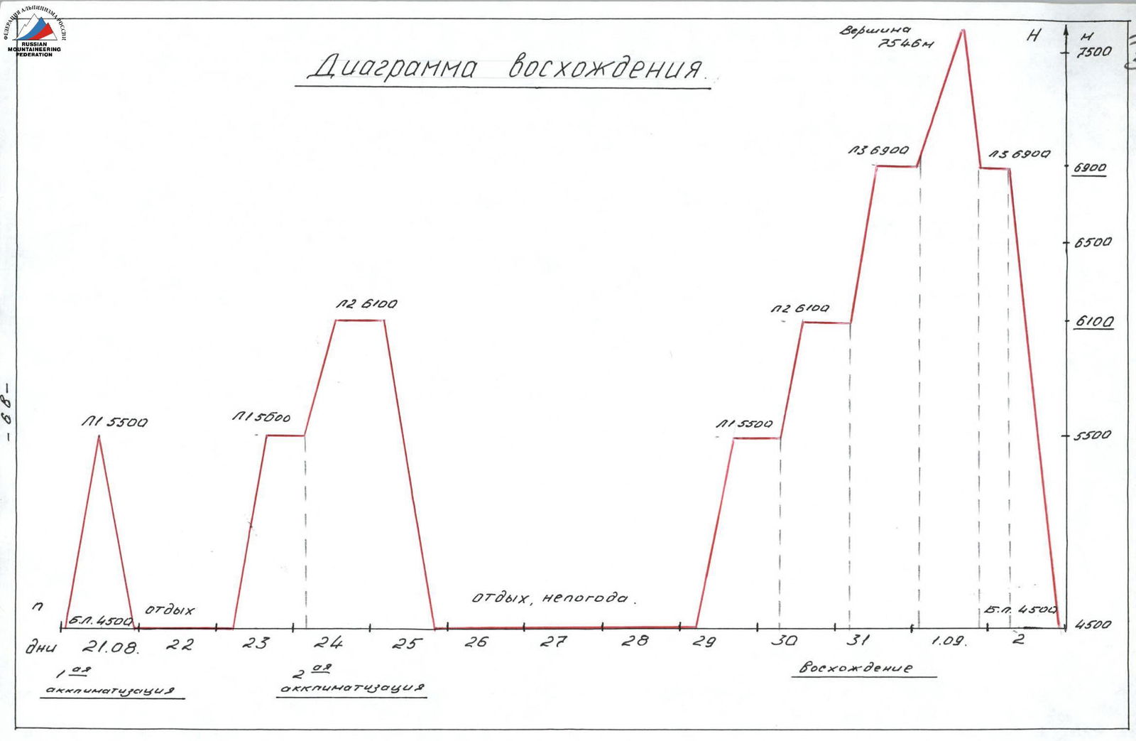
Ascent Diagram
Tactical Actions of the Team
According to the tactical plan, before ascending to the summit, the team carried out step-by-step acclimatization (see diagram).
During the first acclimatization exit, we established the first high-altitude camp at an altitude of 5500 m. We delivered:
- part of the food supplies
- fuel
- equipment
No overnight stay was planned. This section did not present any technical difficulties (see photo 6).
After resting at the base camp, the team's task was to set up the second high-altitude camp (6200 m) with an intermediate overnight stay at R1 (photo 7). According to the tactical plan, a night's stay was also planned at R2 camp. Part # of the food supplies and equipment were also brought here.
The main problem in passing this section was the icefall located between R2 and R1 (see photos 8–11). On the most dangerous and complex sections of the icefall, movement was carried out alternately with piton belays. In two places, perils were set up. Due to the sufficient mobility of the ice seracs and the possibility of their collapse, the "narrow" places of the icefall were passed fairly quickly.
Having gained acclimatization and rested at the base camp, the team was able to complete the ascent. Two high-altitude camps were established, and the trail was partially marked. The only thing that complicated our movement was the large amount of snow that fell after the bad weather. We had to lay a new trail. Often, the lead climber changed.
Due to the late timing of the ascent (end of August – beginning of September), work on the route was mainly carried out in the middle of the day (see ascent graph). It was very cold in the mornings. However, thanks to the optimal location of the high-altitude camps (every 600–700 m in altitude), the daylight hours were quite sufficient. Another problem on the ascent was orientation on the route. In the event of fog or heavy snowfall, there was a real danger of getting lost. The solution to this problem was partial marking of the path with flags.
The summit ascent (see photos 15–16) was made from R3 (6900 m), and there was also an overnight stay after the climb.
The next day, the team returned to the base camp in full.
Route Diagram in UIAA Symbols

P.S. Number of climbing hours — see "Ascent Graph"
Description of the Route by Sections
R0–R1. Section of the route from the base camp (4500 m) to camp R1 (5500 m). No particular technical difficulties. Movement is carried out along a:
- wide
- gentle
- rocky ridge
Movement is simultaneous.
R1–R2. Section of the route from R1 to camp R2 (6200 m). A characteristic feature of this section is the icefall. The icefall is heavily crevassed, with many open and closed crevasses. There are fairly steep ice walls along the route. There is a possibility of ice serac movement and small avalanches. Movement is alternating, with belays via ice screws and ice axes.
R2–R3. Section of the route from R2 to camp R3 (6900 m). The section is a wide snow-ice ridge. There may be closed crevasses at the beginning. Movement is simultaneous. The general direction of movement is northeast. Do not deviate much to the left along the ridge.
R3–R4. A fairly gentle and wide ridge, "The Roof," directly leading to the summit, which is a small island of black rocks.
- Photo 9, section R1–R2 (icefall)

- Photo 10, section R1–R2 (icefall)

- Photo 11, section R1–R2 (ice grotto)

- Photo 12, camp R2 (6200 m)

Comments
Sign in to leave a comment