
Russian Alpinism Championship 2012. High-altitude ascents class
Ascent Report
of the Moscow Alpine and Climbing Federation team to Muztagh-Tower (7273 m)
via the Central Buttress of the Northeast Face, "Think Twice" route — first ascent, approximately 6B category of difficulty
Dedicated to the memory of Pavel Kozek, who perished on the slopes of Muztagh-Tower on August 25, 2008
Senior coach: S. Kotachkov, team leader: S. Nilov
Moscow 2012
Ascent Passport
-
Karakoram, Pakistan — section 10.2 according to KMGV 2008
-
Muztagh-Tower (7273 m) via the Central Buttress of the Northeast Face, "Think Twice" route.
-
Proposed category: 6B, first ascent
-
Route characteristics:
5250–6500 m — snowy-icy slope with a steepness of about 60°; 6500–7100 m — rocky bastion with a steepness of about 80°; 7100–7273 m — summit area, snowy-icy slope with an average steepness of 30°.
-
Route start: 5250 m
Summit: 7273 m. Elevation gain: 2023 m. Route length: 3400 m. Section lengths: V category of difficulty — 900 m, VI category of difficulty — 600 m. Average steepness: main part of the route — 73°; entire route — 60°.
-
Pitons left on the route: 6; including 4 bolt pitons
-
Team's total climbing hours: 148 h, 18 days
-
Team leader: Nilov Sergey Alekseyevich — Master of Sports
Team members: Golovchenko Dmitry — Candidate for Master of Sports, Lange Alexander — Candidate for Master of Sports
-
Coach: Kotachkov Sergey — Candidate for Master of Sports
-
Departure from Base Camp:
Route started: 9:00 AM, August 9, 2012. Summit reached: 7:00 AM, August 25, 2012. Return to Base Camp: 8:00 PM, August 26, 2012. Descent: 24 hours non-stop via the North Face: from 8:00 AM, August 25, 2012, to 7:00 AM, August 26, 2012.
-
Organizing body: Moscow Alpine and Climbing Federation, national team
-
Lange Alexander (lange@mail.ru, +7–903–131–80–48),
Golovchenko Dmitry (mighty83@yandex.ru, +7–926–367–72–61)
Technical photo of the face with the ascent route marked.
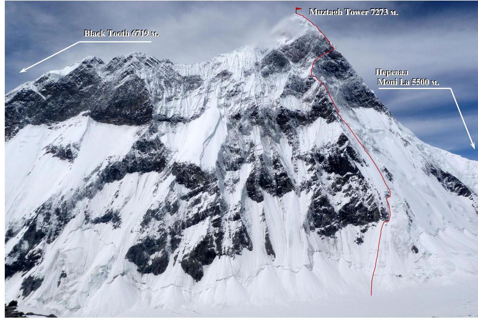
General photo of the Northeast Face with the only route marked, pioneered by our team. In 2008, a well-known Slovenian alpinist attempted to climb this face much further east, near Black Tooth peak (6719 m).
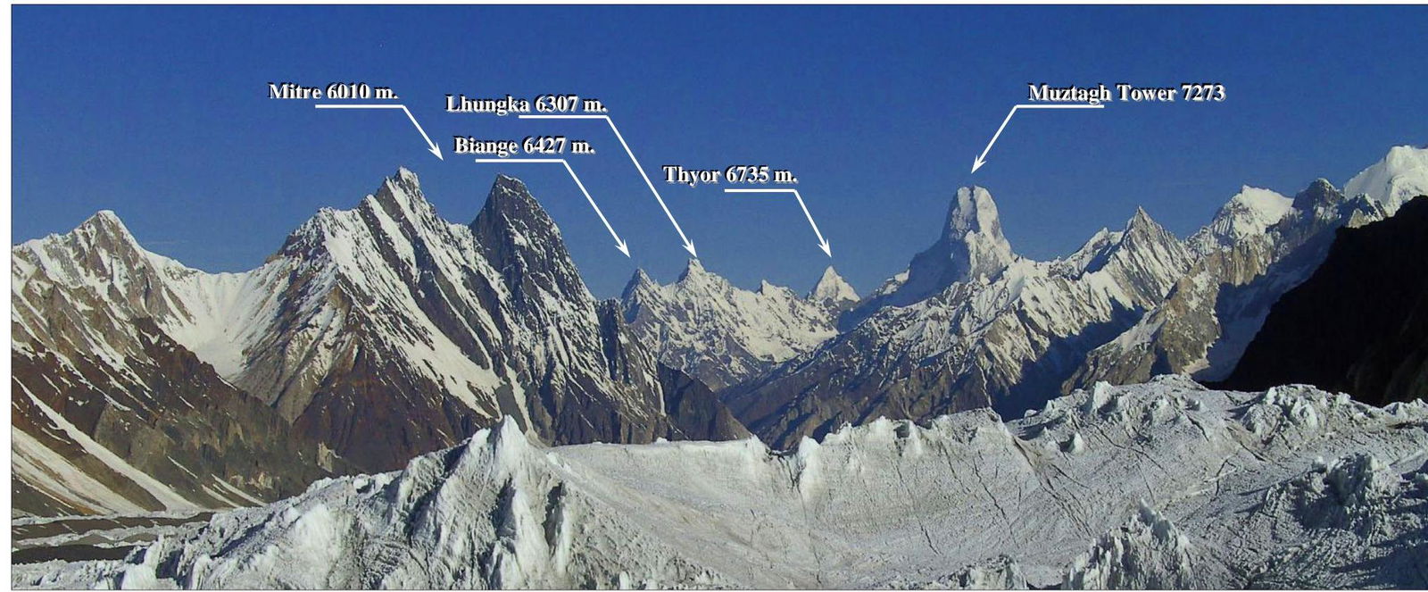
Panorama of the area.
Area Overview
Karakoram — "black gravel" (Turkic). A mountain range in Central Asia, forming the watershed between the Indus and Tarim rivers. Karakoram stretches from northwest to southeast, from the Baroghil Pass to the bend of the Shyok River, for 550 km across the territories of three countries: Pakistan, China, and India.
Karakoram's climate, due to its high-altitude, deeply dissected relief, low-latitude location, and significant east-west extent, is characterized by large contrasts:
- In deep intermontane valleys, the climate is dry and warm, allowing for agriculture with artificial irrigation.
- High in the mountains, at the level of the snowline (about 5000 m above sea level), the average annual air temperature is between –5 and –4 °C. Annual precipitation is 1200–2000 mm, almost exclusively in solid form.
The primary source of atmospheric precipitation is the western moisture transfer from the Atlantic and the Mediterranean, with spring and autumn cyclones [3]. The role of the Indian monsoon in forming precipitation in Karakoram is less significant, as it arrives already greatly weakened. Precipitation varies across regions:
- More falls in the western and southern parts of Karakoram.
- Less in the eastern and northern parts.
Accordingly, the height of the snowline also varies:
- In the southwest — 4600–5000 m (lowest).
- In the north — 5000–6000 m.
- In the northeast — 6200–6400 m.
The Karakoram territory belongs to the Alpine fold belt, occupying an intermediate position between the structures of the Pamir and the Himalayas. The Karakoram mountain system's structure is of a fold-block character. The composition of rocks changes direction from southwest to northeast:
- The southwestern part is composed of gneisses and granites.
- In the northeast, dark schists and sandstones predominate.
- Further, they are replaced by limestones and crystalline schists.
Karakoram is the largest and most compact center of modern mountain glaciation in low latitudes:
- Glaciers occupy more than 16% of the total area of the mountain system.
- In the western part — more than 30%.
- The total area of glaciation is 15,400 sq. km.
Muztagh-Tower (Urdu مضطجّع گذر, English Muztagh Tower, translated as "Ice Mountain" from Uyghur) (7273 m) — a mountain located in the Baltoro Muztagh range, part of the Karakoram mountain system in Gilgit-Baltistan. The mountain is situated between two glaciers: Baltoro and Sarpo Laggo. Muztagh-Tower is the 91st highest peak in the world. The name "Muztagh" means "ice mountain" in Uyghur.
Ascent history:
-
Dramatic photos of Muztagh-Tower taken by Italian photographer Vittorio Sella during an expedition to Chogori in 1909, made the peak famous.
-
In 1956, two expeditions — British and French — competed for the first ascent.
- The British expedition (John Hartog, Joe Brown, Tom Pati, Ian McNout-Davis) ascended from the west and reached the summit on August 6, 1956.
- The French team ascended from the east and reached the summit five days later.
- Dr. François Florenzi waited for both teams at Camp IV for 42 hours without radio communication.
-
After 1956, there were many attempts, but only two were successful:
- An English expedition in 1984.
- A Swedish expedition in 1990.
-
On August 25, 2008, two Slovenian alpinists — Pavle Kozek and Dejan Miškovič — were ascending the northeast side.
- After 17:00, they set up a camp.
- Later, a strong wind began, and the alpinists decided not to proceed to the summit.
- During the descent, Kozek fell and perished.
Map of the area.

Ascent graph.

Drawn profile of the route to Muztagh Tower via the Central Buttress of the Northeast Face.
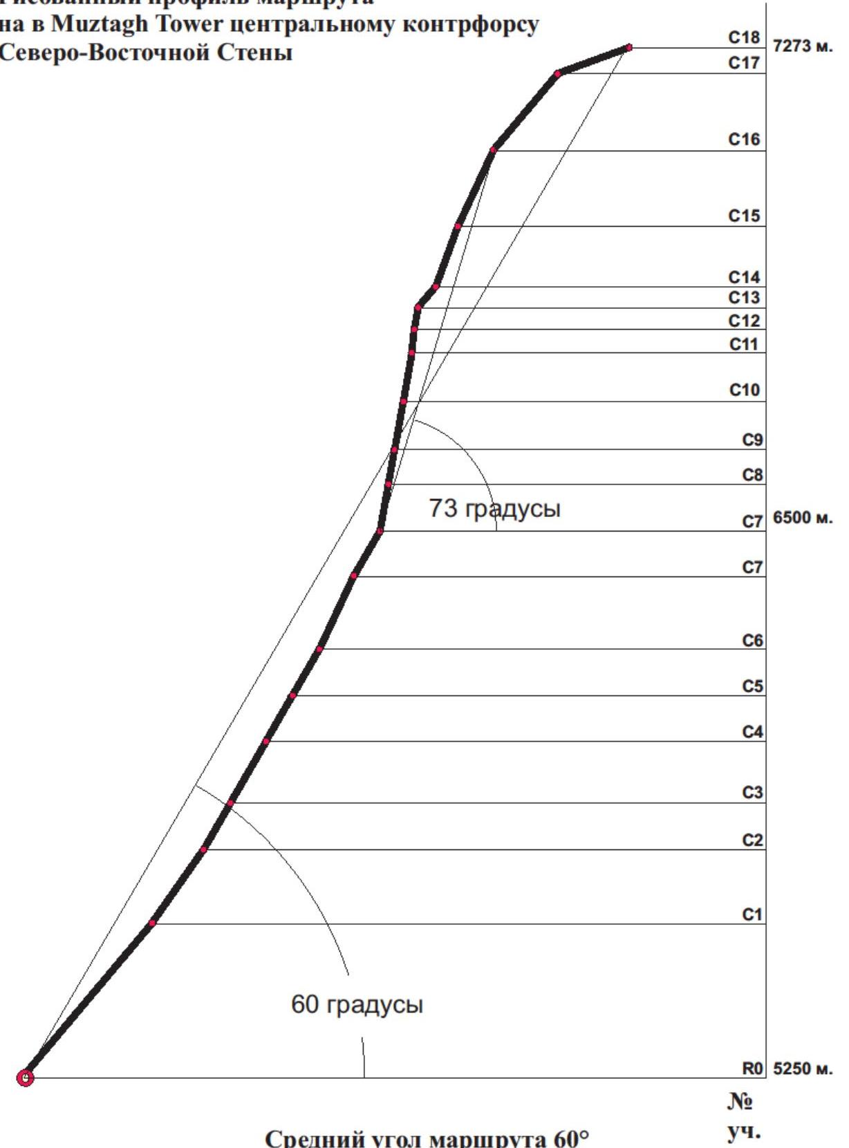
The average angle of the route is 60°. The average angle of the wall section is 73°. UIAA route diagram.
Route Description by Sections
| Section | Description | Length, Steepness, Category of Difficulty |
|---|---|---|
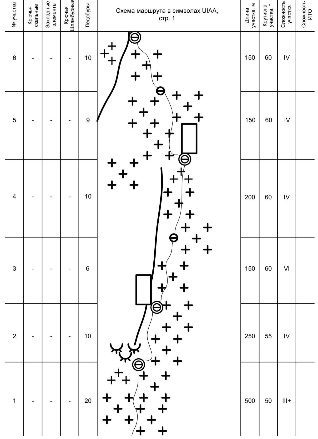
| R0–R1 | Up the snowy talus directly upwards, then up the snowy-icy slope under the base of protruding rocks. A platform for overnight stay under the rocks. | 500 m, 50°, III+ |
| R1–R2 | Along the snowy-icy slope, bypass the rocks on the right for 20 m, then upwards to the base of protruding rocks, to the overnight stay location. | Snow, ice, 250 m, 55°, IV; |
| R2–R3 | From the belay station, upwards to the right along the snowy-icy slope, alongside the rocky ridge on the left. | 150 m, 60°, IV; |
| R3–R4 | Continue moving along the ridge to the base of a large rocky outcrop. Overnight stay under the rocks. | 200 m, 60°, IV; |
| R4–R5 | Bypass the rocky outcrop on the left, move directly upwards along the snowy-icy slope. | 150 m, 60°, IV; |
| R5–R6 | Continue moving upwards along the snowy-icy slope and exit onto the buttress. Overnight stay on a snowy ledge on the buttress. | 150 m, 60°, IV; |
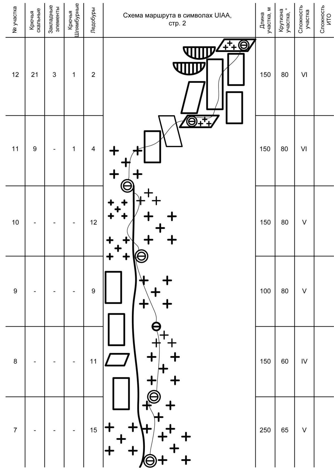
| R6–R7 | From the belay station, upwards on ice, sometimes moving left. Overnight stay on a sloping snowy shelf. | 250 m, 65°, V; |
| R7–R8 | Continue moving upwards on ice, always striving to reach the junction of the "saw" with the NE slope. | 150 m, 60°, V; |
| R8–R9 | Up the steep, unstable snow to reach the "saw". Camp on a snowy ledge on the "saw". | 100 m, 80°, V; |
| R9–R10 | Move along the "saw" vertically upwards with periodic changes in direction. Camp on a snowy ledge on the "saw". | 150 m, 80°, V; |
| R10–R11 | From the camp, initially vertically upwards on ice, then to the right on rocks. Overnight stay on a sloping snowy shelf. | 150 m, 80°, VI; |
| R11–R12 | Continue |
| Section | Description | Length, Steepness, Category of Difficulty |
|---|---|---|
| to move to the right in the direction of the North ridge. Overnight stay on a sloping snowy shelf. | 150 m, 80°, VI; | |
| R12–R13 | From the belay station — vertically upwards on very difficult rocks. | 50 m, 85°, VI, A2; |
| R13–R14 | Up the rocks to approach the start of a large oblique snowy-icy shelf. | 50 m, 80°, VI; |
| R14–R15 | Exit onto the oblique snowy-icy shelf, up the shelf to the left, at the end of the shelf, belay on a piton. | 50 m, 50°, IV; |
| R15–R16 | Bypass the rocks on the left, continue moving upwards to the right in the direction of the North ridge. | 200 m, 70°, VI; |
| R16–R17 | From the belay station, move upwards on steep, re-frozen ice in the direction of hanging ice on the North ridge. Bypass the overhangs on the left and exit onto snow. | 250 m, 65°, V; |
| R17–R18 | Along the snow, along the boundary of the North ridge, ascend to the "roof". Overnight stay in a crevasse on the slope. | 250 m, 50°, IV; |
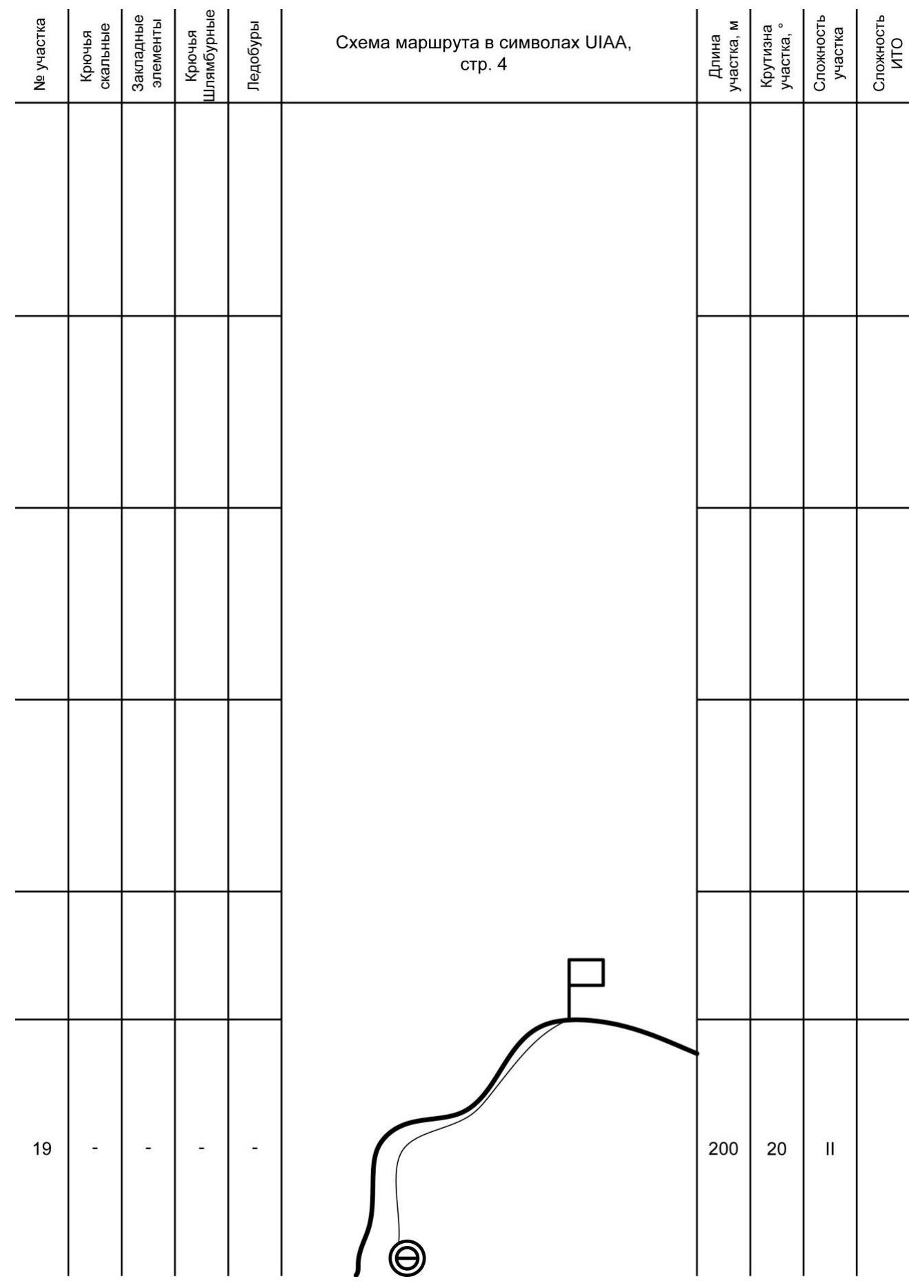
| R18–R19 | Along a gentle snowy ridge, ascend to the summit, which is a large snowy ledge. | 200 m, 20°, II; |
Descent via the Northwest Face, non-stop, from 8:00 AM, August 25, 2012, to 7:00 AM, August 26, 2012.
Technical photo of the route.
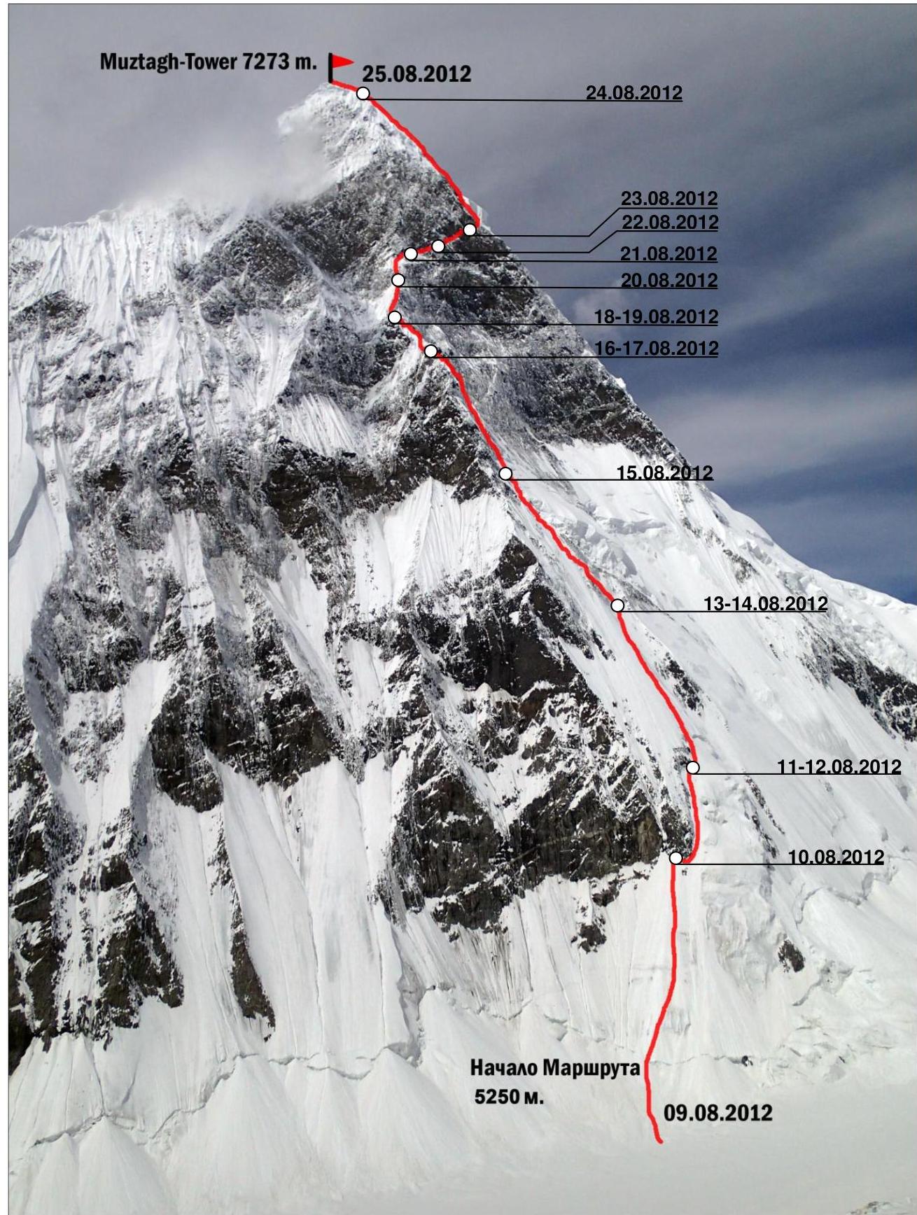
Muztagh-Tower 7273 m.
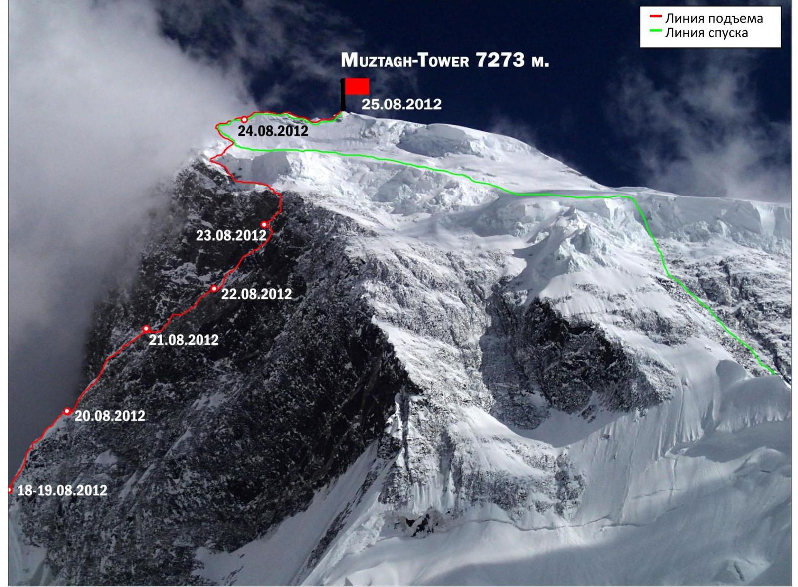
- Ascent route
- Descent route
Team's Tactical Actions
Upon arrival at the ascent area, the team conducted several acclimatization climbs in the vicinity of the Moni La Pass (5500 m). A reconnaissance was carried out to inspect the northeast and north faces of Muztagh-Tower. Possible routes were identified: via the Central Buttress of the Northeast Face; via the North ridge from Moni La Pass. Descent options were also considered: via the Northwest ridge; via the North Face.
During the discussion, the team chose the Central Buttress of the Northeast Face as the safer option.
During the ascent, the team demonstrated high organization, strong physical and moral-volitional preparation. All team members conducted preparatory training, which yielded positive results during the ascent.
The team worked according to the principle:
- The first climber ascends and sets up the rope, which the second follows.
- The second belays the first and simultaneously pulls up the rucksack.
- The third, moving along the rope, assists.
Throughout the ascent, the team maintained radio contact with the coach at Base Camp or ABC. The ascent was adjusted as necessary.
The technical gear used included:
- Dynamic and static ropes manufactured by Vento (4 pieces total);
- Crampons, ice axes, and ice screws for ice and snow climbing, manufactured by Grivel, Petzl — Charlet Moser, BlackDiamond;
- Ice screws, anchor pitons, chocks, and cams for rock climbing, manufactured by Russian and foreign producers;
- Each participant had a personal set of gear for ascending ropes, a hammer, a set of carabiners, and a belay device.
Photo illustrations.
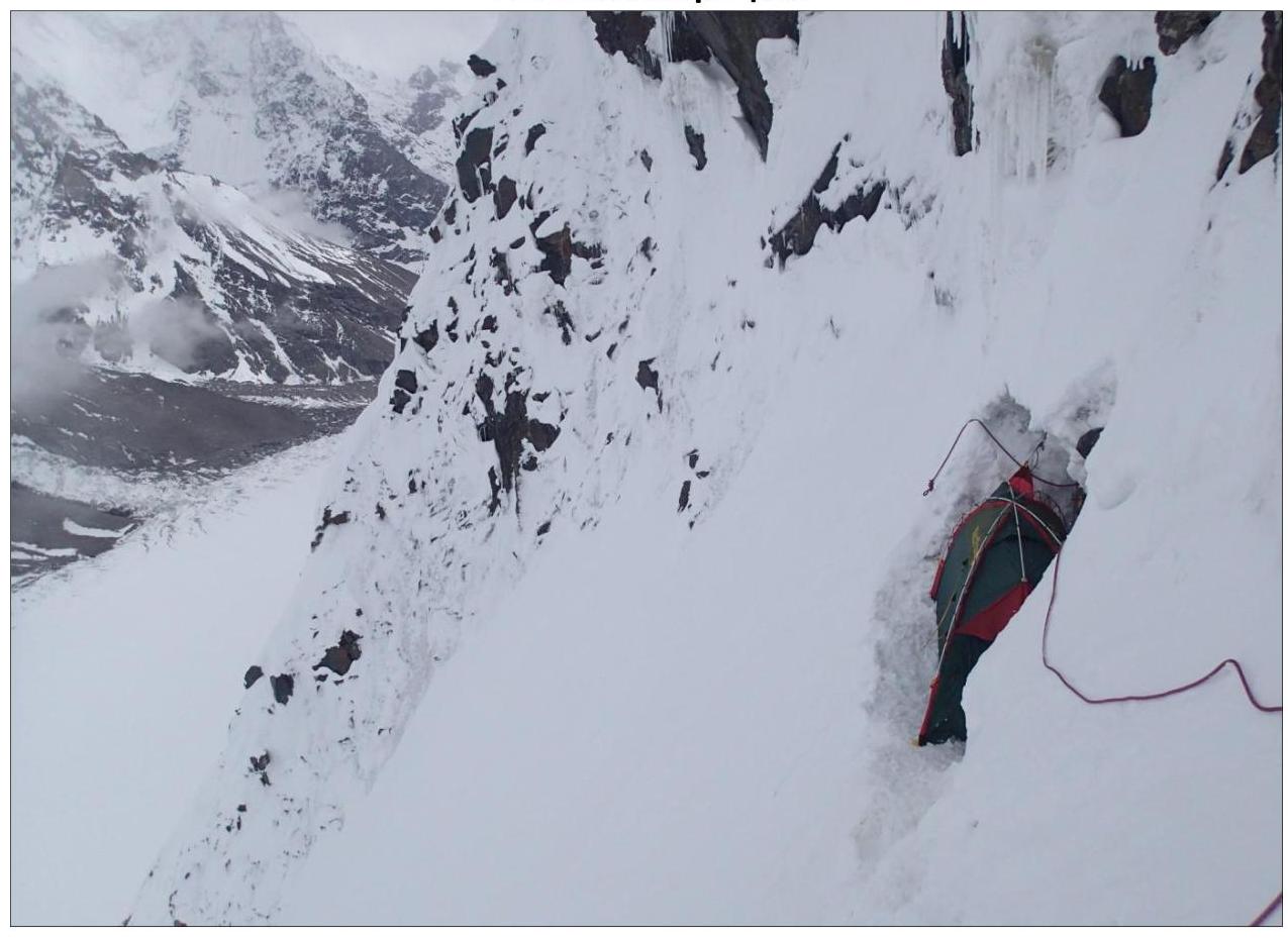
Photo 1: Second camp
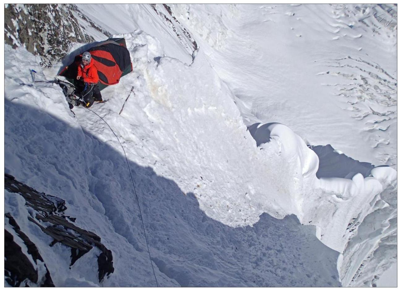
Photo 2: Seventh camp
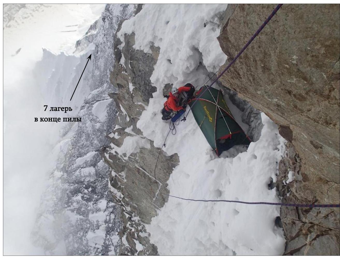
Photo 3: Tenth camp
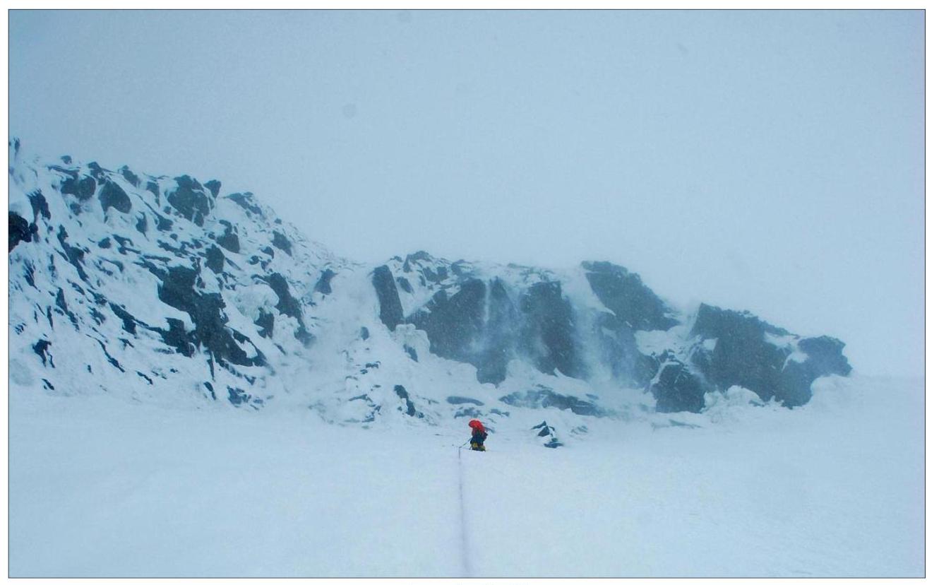
Photo 4: R1–R2

Photo 5: R2–R3
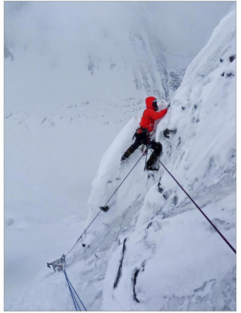
Photo 6: R3–R4
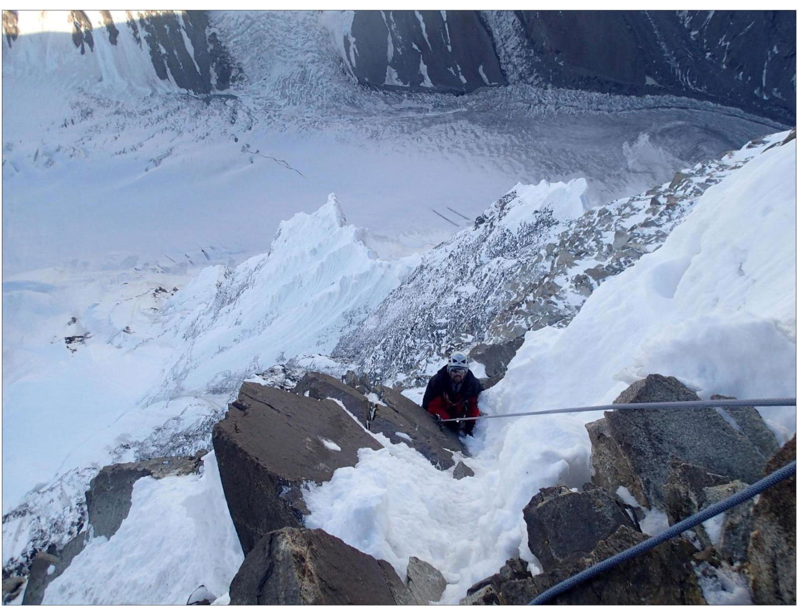
Photo 7: R10–R11
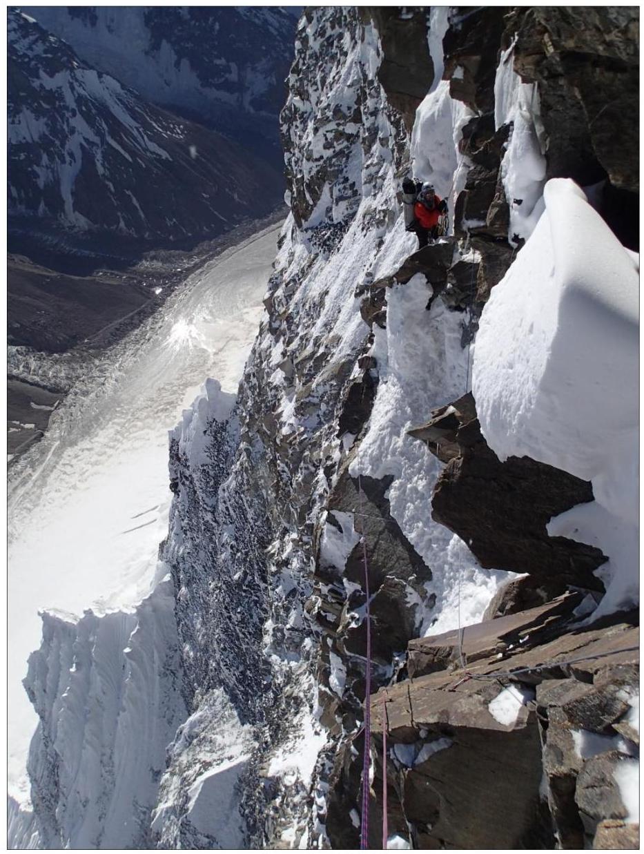
Photo 8: R11–R12
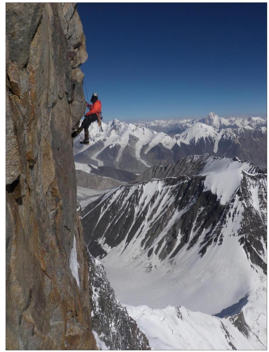
Photo 10: R12–R13

Photo 11: R16–R17
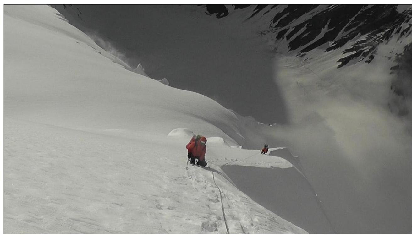
Photo 12: Pre-summit ridge: View to the north.
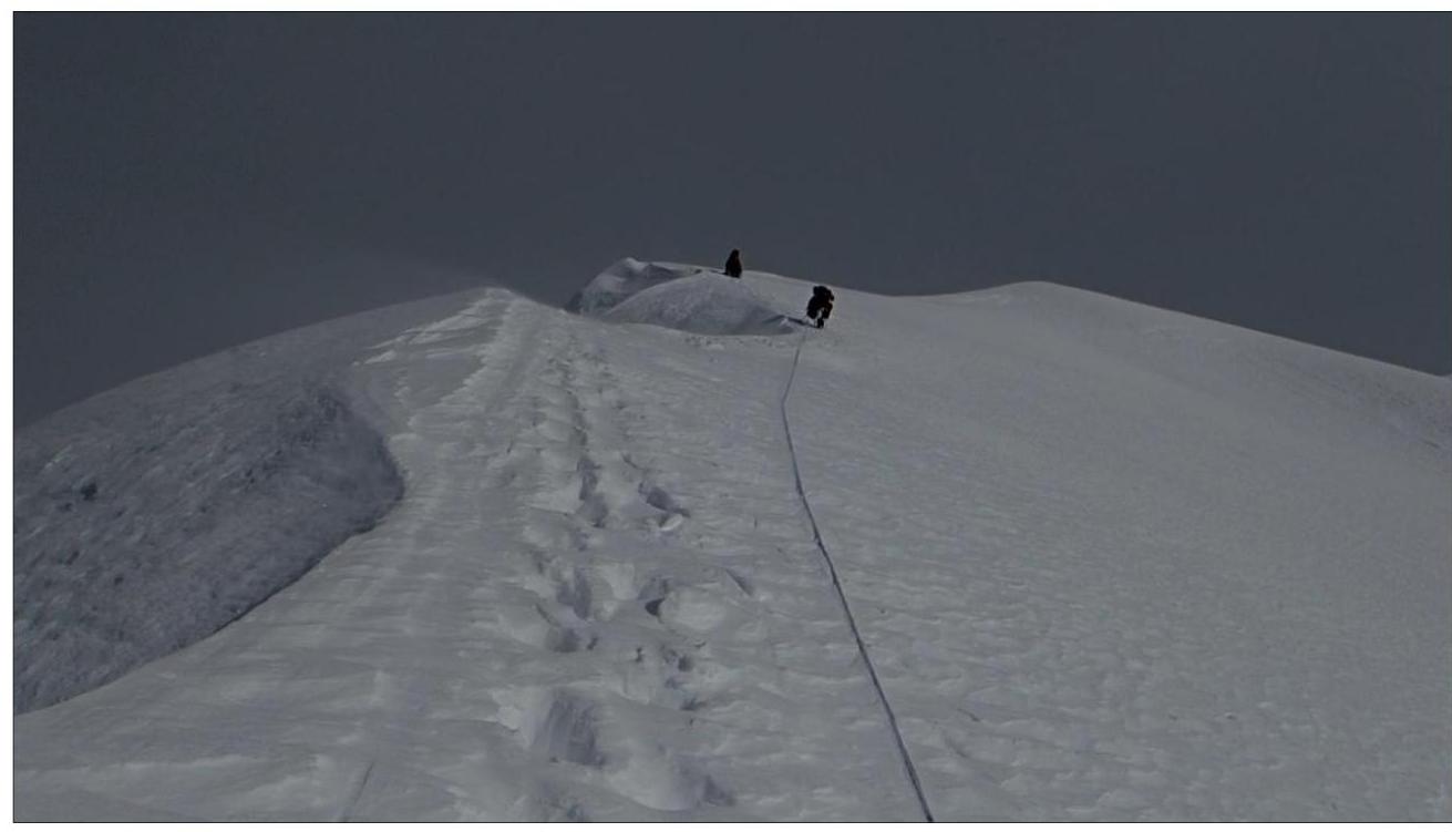
Photo 13: View to the southeast.
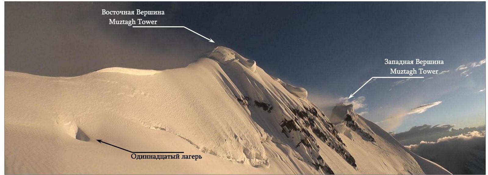
Muztagh-Tower has two summits: western and eastern. The eastern summit is the higher one, at 7273 m. The western summit is significantly lower, with no exact data available.
In 1990, the well-known Swedish alpinist Goran Kropp ascended only the western summit via the English route along the Northwest ridge. The French route along the Southeast ridge leads directly to the eastern summit.
Our route goes via the Northeast Face and leads to the North ridge, which in turn leads to the eastern summit of Muztagh-Tower, 7273 m.
Footnotes
-
150 m, 80°, VI ↩
Comments
Sign in to leave a comment