
Report
On the Ascent to Kongur Peak (7719)
Via the NW buttress of the NW wall ("Moscow Express") 6A category of difficulty (Third passage of the route)
1. Climbing Passport
- Region: Kongur-Muztagh Range (Chinese Pamir). Valley: Karayaylak Section number according to the 2001 classification table — 11.3
- Summit name: Kongur. Route name: Via the NW buttress of the NW wall ("Moscow Express")
- Category of difficulty — 6A.
- Route type: combined.
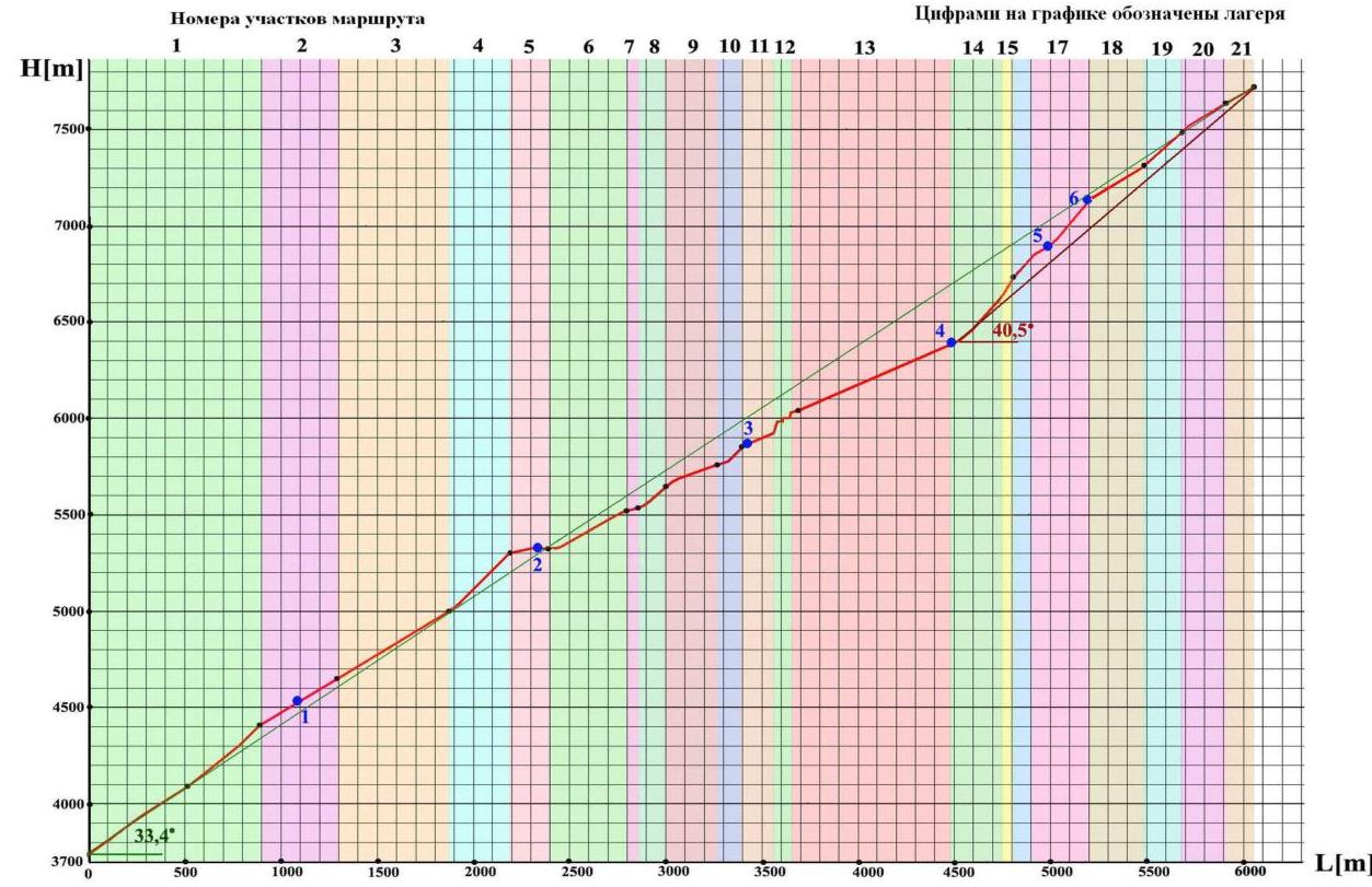
- Route elevation gain: 3988 m (according to GPS readings) Route length: 7287 m. Length of sections: category V — 822 m, category VI — 145 m. Average slope: main part of the route – 40.5°, including: sections 5050–5250 – 50°, 6500–6740 – 53°, 6740–6850 – 48°, entire route – 33.4°.
- Pits used: rock — 26, ice — 65, including ITO — 0. Pitons (stationary, removable) were not used.
- Team's total climbing hours: 55 hours, 7 days
- Leader: Lebedev Andrey Alexandrovich (Moscow), MSMS (tourism), 1st sports category (alpinism)
Team members:
- Bezditko Sergey Vasilievich (Moscow), MSMS (tourism), 1st sports category (alpinism),
- Zharov Andrey Viktorovich (Moscow, Zelenograd), 1st sports category (tourism),
- Zhdanov Ivan Nikolaevich (Moscow), 1st sports category (tourism),
- Timoshenkov Alexey Sergeevich (Moscow, Zelenograd), 1st sports category (tourism), 2nd sports category (alpinism)
- Chizhik Dmitry Vladimirovich (Moscow), CMS (tourism), 2nd sports category (alpinism)
- Coach: Khokhlov Yuri Vladimirovich (Moscow), MS (alpinism).
- Departure to the route: 11:00 August 27, 2007 Summit arrival: 14:10 September 3, 2007 Return to base camp: 20:10 September 7, 2007
The ascent was carried out without prior processing of the route in "Alpine" style and took place within the framework of a 6th category of difficulty sporting mountain trip, entered for the Russian tourism championship.
Route logbook No. RG-610–06/07, approved on 04.07.2007 by MKK TSSR, see also a brief report on the trip [1].
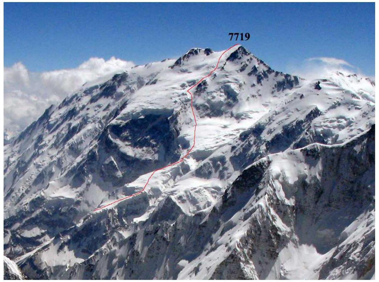
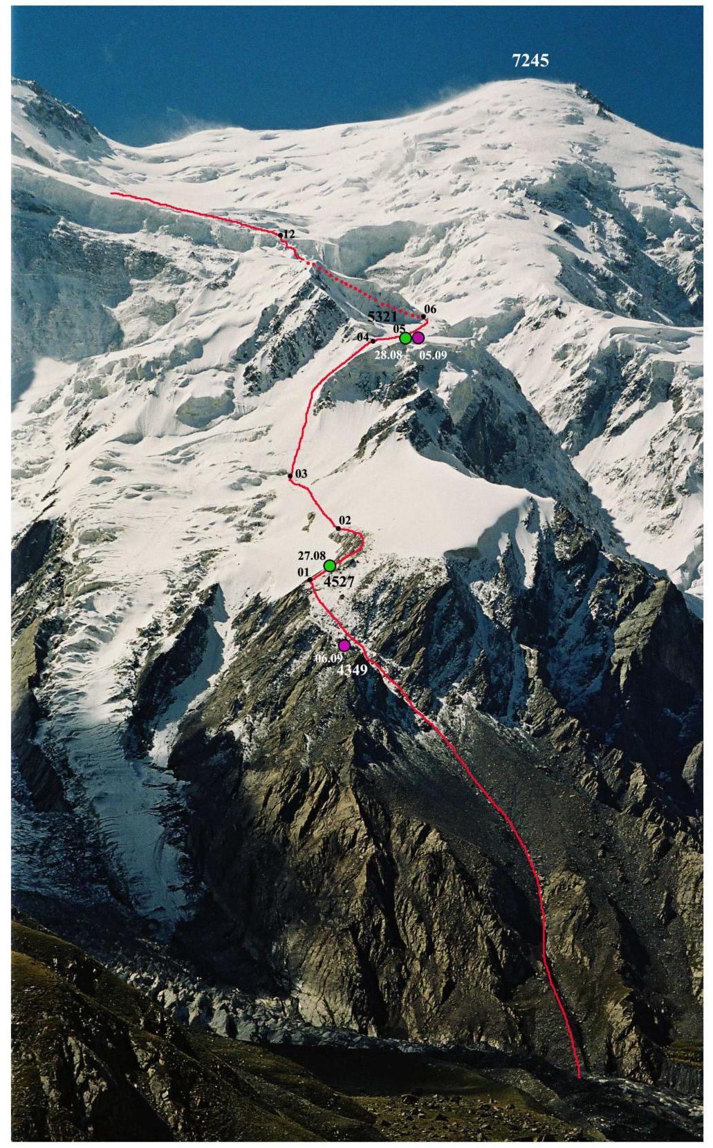
2. Summit Photograph

General photo of the summit. View of Kongur from the north from the moraine of the Karayaylak glacier. Taken in June 2005.
Routes traversed:
- Red track (1) — route traversed by the team.
- Lilac track (2) — lower part of the route in the version of Yu. Khokhlov's team (2004).
- Green track (3) — upper part of the route in the version of V. Shamalo's team (2004); at the bottom, V. Shamalo's team also followed the lilac track (2).
3. Route Profile Photograph
Route profile. View of Kongur from the summit of Akalangam (7004). August 2007.
4. Hand-Drawn Route Profile
5. Area Photopanorama
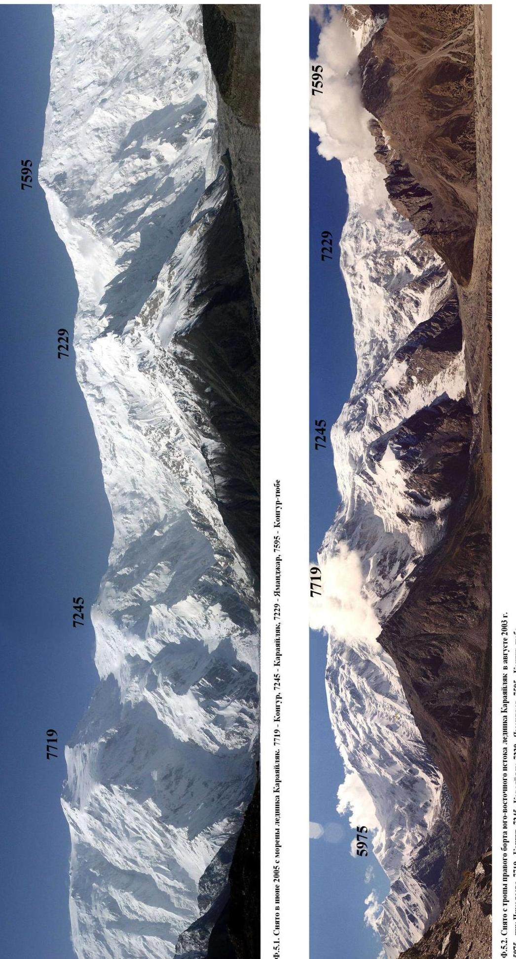
F.5.1. Taken in June 2005 from the moraine of the Karayaylak glacier. 7719 — Kongur, 7245 — Karayaylak, 7229 — Yamandar, 7595 — Kongur-tube. F.5.2. Taken from the path on the right bank of the southeastern source of the Karayaylak glacier in August 2003. 5975 — Nikolaev Peak, 7719 — Kongur, 7245 — Karayaylak, 7229 — Yamandar, 7595 — Kongur-tube.
6. Description of Kongur and the Area North of the Summit
Kongur Peak (7719) is located in the Kongurtagh Range, which is part of the Kongur-Muztagh Range, the main range of the Kashgar Mountains (Chinese Pamir), and stretches in a latitudinal direction south of the Gözdar'ya valley. The Karakoram Highway (Kashgar — Gilgit) runs along the bottom of the valley. The nearest settlement to the summit on this highway is the village of Göz (17 km from the base camp).
The Kongurtagh Range includes peaks (listed from west to east): Akalangam (7004), Kokodag (7210), Kongur-tube (7595), Yamandar (7229), Karayaylak (7245), and Kongur (7719). In this section, the range does not drop below 6666 m. The watershed of the Kongur-Muztagh Range turns from Karayaylak Peak to the south towards Koksel Peak (6715).
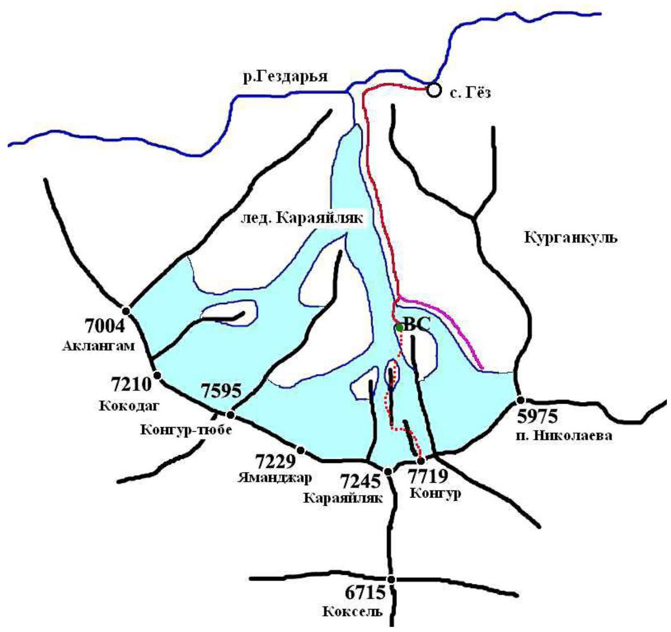
Area Map
The first ascent of Kongur was made by a British team led by C. Bonington in 1981. Their route (along the western ridge of Kongur) started from the southwest of Kongur and traversed through Karayaylak Peak.
No routes have been climbed on the southern wall of Kongur. Attempts to ascend via the logical southeastern ridge have also not been made. Attempts to reach the summit via the northeastern ridge were mainly made from the southeastern branch of the Karayaylak glacier (Japanese expedition in 1981), or from the more eastern Kuran-Kol valley through Nikolaev Peak (5975) (Italian expedition in 2004).
The first attempt to ascend via the long, jagged northern ridge (route through the "Japanese umbrella") was made by the Japanese in 1981 and ended tragically. Three Japanese climbers who started the route went missing. C. Bonington's team did not find any traces of their presence on the summit. An attempt to ascend via the northern ridge was made by the FAIS Moscow team in 2002.
Attempts to ascend via the northern ridge:
- Japanese team in 1981
- FAIS Moscow team in 2002
The second successful ascent of Kongur was made by Russian climbers in 2004. Three teams (a team from St. Petersburg, led by V. Shamalo, a team from FAIS Moscow and SK MAI, led by Yu. Khokhlov, and a team from Krasnoyarsk, led by N. Zakharov) began processing the NW buttress of the NW wall, which descends to the north from the plateau between Kongur and Karayaylak peaks. The St. Petersburg team turned left from the plateau and ascended to the ice cap of Kongur at the far upper end of the plateau, while the Moscow and Krasnoyarsk teams made a similar turn at the lower left corner.
Approaches to the northern routes and the northeastern ridge of Kongur are made through the Karayaylak valley along the glacier of the same name. The path starts from the village of Göz (2350) and turns west. After 5 km, the path turns south and enters the Karayaylak valley. At the turn, there is a mausoleum (2800). Further, the path follows the orographic right moraine of the Karayaylak glacier. After the last camp before the mouth of the southeastern source of the glacier, one of the paths descends to the glacier and crosses the southeastern source, rising to the moraine 300 m west of the tip of the northern ridge of Kongur. Here, in the pocket of the moraine, is the traditional location for a base camp serving ascents via the NW buttress of the NW wall. The camp height is 3613 m (17 km from the Göz village). For water, they go to the stream near the NW buttress of the northern ridge of Kongur (~300 m).
The path to the base camp for the ascent via the northern ridge of Kongur almost coincides with the described one and differs only in an additional short transition along the moraine pocket to the eastern side of the NW buttress of the northern ridge.
The path to the northeastern ridge of Kongur follows the path in the pocket of the orographic right moraine of the southeastern source of the Karayaylak glacier.
All the approaches described above are accessible for pack animals. The weather in the Kongurtagh area is determined not only by Atlantic cyclones. Unlike the Badakhshan Pamir, which is protected from the south by the high ridges of the Hindu Kush, monsoons penetrate here:
- from the Indian Ocean (from the south along the Indus valley and the Khudora Pass),
- and from the Pacific Ocean (from southeastern China).
Therefore, the weather here is less stable and approaches the weather in the Pobeda Peak area. Prolonged anticyclones are practically absent here. On average, the weather changes every 3–4 days. As a result, there is little open ice in the area, a deep snow cover, and it is avalanche-prone. The snow cover is particularly difficult to navigate at altitudes of 5200–6000 m. Higher up, the snow is compacted by strong winds and partially blown away.
7. Route Area Map
Numbers on the track indicate camps
8. Ascent Schedule
| Date | Climbing Time [h] | Ascent [m] | Elevation Change [m] | Transition Description |
|---|---|---|---|---|
| 27.08 | 7 | 914 | 3613–4527 | BC–C1 (sections R1 and R2) |
| 28.08 | 11 | 794 | 4527–5321 | C1–C2 (sections R2–R5) |
| 29.08 | 9 | 536 | 5321–5857 | C2–C3 (sections R5–R10) |
| 30.08 | 9 | 534 | 5857–6391 | C3–C4 (sections R11–R13) |
| 31.08 | 0 | 0 | 6391 | C4 (rest) |
| 01.09 | 10 | 499 | 6391–6890 | C4–C5 (sections R14–R17) |
| 02.09 | 4 | 261 | 6890–7151 | C5–C6 (section R17) |
| 03.09 | 7 | 568 | 7151–7719–7151 | C6–summit–C6 (sections R18–R21) |
| 04.09 | 7 | 0 | 7151–6045 | C6–C3* |
| 05.09 | 9 | 0 | 6045–5321 | C3*–C2 |
| 06.09 | 12 | 0 | 5321–4349 | C2–C1* |
| 07.09 | 12 | 0 | 4349–3613 | C1*–BC |
Height [m]
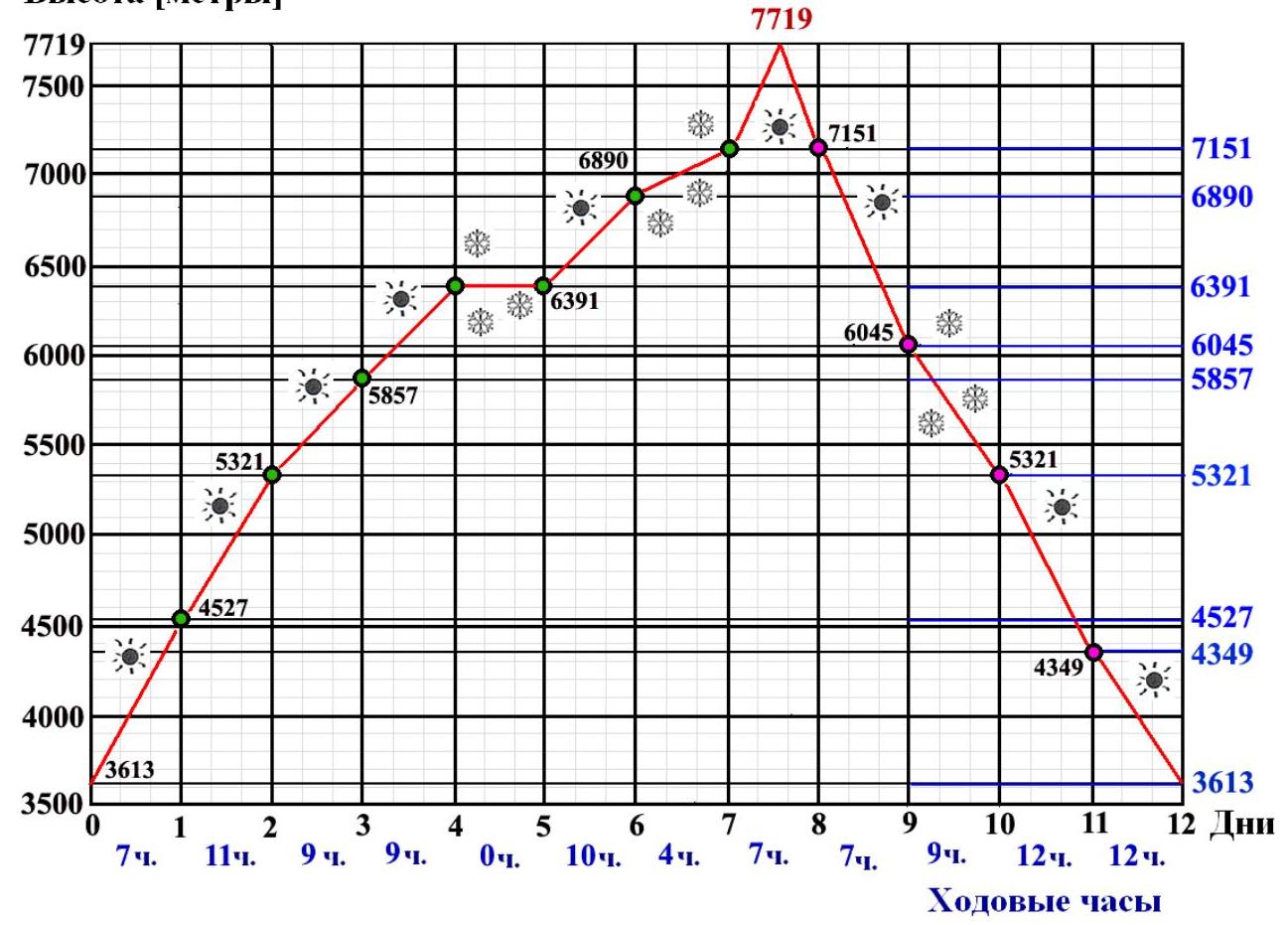
The slow descent rate in the last three days is due to rescue operations, see Appendix to the report.
9. Route Diagram on a 1:15000 Scale
Sheet 1 (lower part of the route, sections R1–R9)
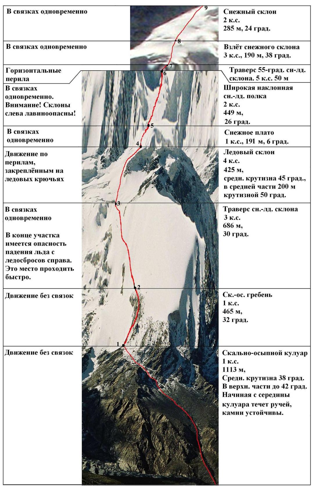 Climbing in pairs simultaneously
- Snow slope
- 2 category of difficulty
- 285 m, 24° Climbing in pairs simultaneously
- Snow slope ascent
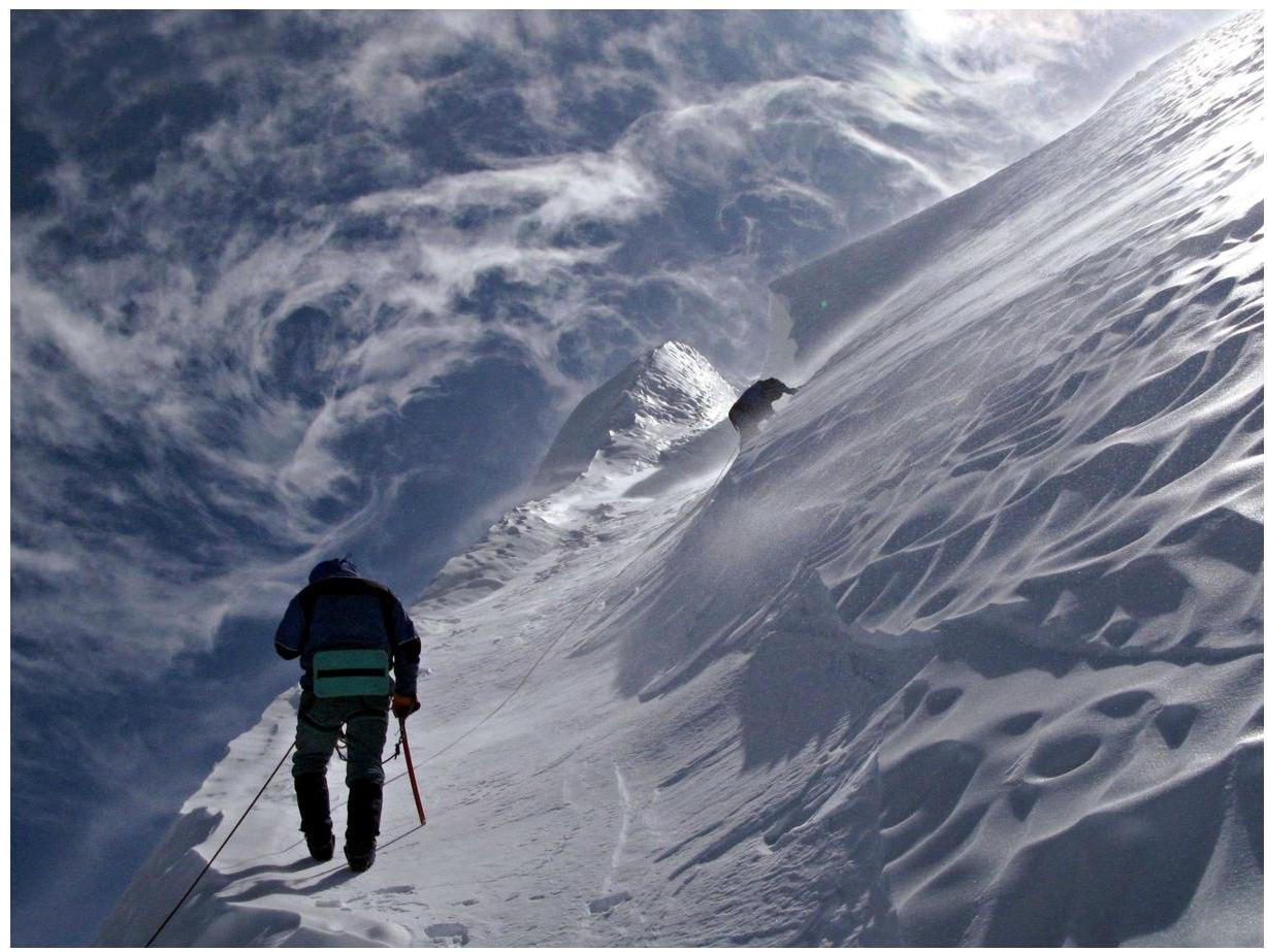
- 3 category of difficulty, 190 m, 38° Horizontal railings Climbing in pairs simultaneously. Attention! Slopes on the left are avalanche-prone! Climbing in pairs simultaneously
- Traverse of a 55-degree sn-ice slope. 5 category of difficulty 50 m
- Wide inclined sn-ice shelf
- 2 category of difficulty
- 449 m,
- 26°
- Snow plateau
- 1 category of difficulty, 191 m, 6°
- Ice slope
- 4 category of difficulty
- 425 m,
- average slope 45°,
- in the middle part 200 m
- slope 50° Climbing along railings fixed on ice screws Climbing in pairs simultaneously
- Traverse of sn-ice slope
- 3 category of difficulty
- 686 m,
- 30° At the end of the section, there is a danger of ice falling from ice drops on the right. Pass this place quickly. Climbing without ties
- Rocky-ash ridge
- 1 category of difficulty
- 465 m,
- 32° Climbing without ties
- Rocky-ash gully
- 1 category of difficulty
- 1113 m,
- Average slope 38°
- In the upper part up to 42°
- Starting from the middle
- of the gully, there is a stream,
- stones are stable.
Sheet 2 (upper part of the route, sections R10–R21)
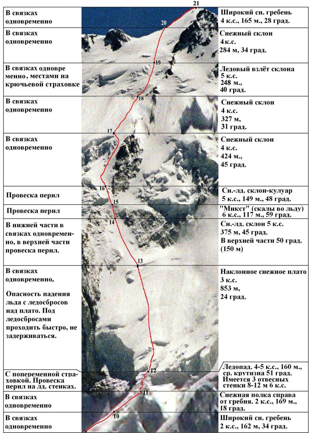 Climbing in pairs simultaneously
- Wide sn ridge
- 4 category of difficulty, 165 m, 28° Climbing in pairs simultaneously
- Snow slope
- 4 category of difficulty
- 284 m, 34° Climbing in pairs simultaneously, partly on piton insurance
- Ice slope ascent
- 5 category of difficulty
- 248 m,
- 40° Climbing in pairs simultaneously
- Snow slope
- 4 category of difficulty
- 327 m,
- 31° Climbing in pairs simultaneously
- Snow slope
- 4 category of difficulty
- 424 m,
- 45° Railing setup
- Sn-ice slope-gully
- 5 category of difficulty, 149 m, 48° Railing setup
- "Mixed" (rocks in ice)
- 6 category of difficulty, 117 m, 59° In the lower part, climbing in pairs simultaneously, in the upper part, railing setup.
- Sn-ice slope
- 5 category of difficulty
- 375 m, 45°
- In the upper part 50° (150 m) Climbing in pairs simultaneously. Danger of ice falling from ice drops above the plateau. Pass under ice drops quickly, do not linger.
- Inclined snow plateau
- 3 category of difficulty
- 853 m,
- 24° With alternating insurance. Railing setup on ice walls.
- Icefall. 4–5 category of difficulty, 160 m, average slope 51°. There are 3 sheer walls 8–12 m, 6 category of difficulty. Climbing in pairs simultaneously
- Snow shelf to the right of the ridge.
- 2 category of difficulty, 169 m, 18° Climbing in pairs simultaneously
- Wide sn ridge
- 2 category of difficulty, 162 m, 34°
10. Route Section Breakdown
| N | Section Description | Start Height [m] | End Height [m] | Tech. Difficulty | Difficulty with Height | Length [m] | Average Slope [°] |
|---|---|---|---|---|---|---|---|
| R1 | Rocky-ash gully | 3731 | 4413 | 1 | 1 | 1113 | 38 |
| R2 | Rocky-ash ridge | 4413 | 4658 | 1 | 1 | 465 | 32 |
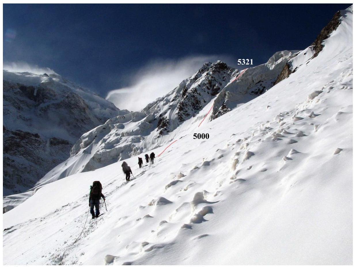
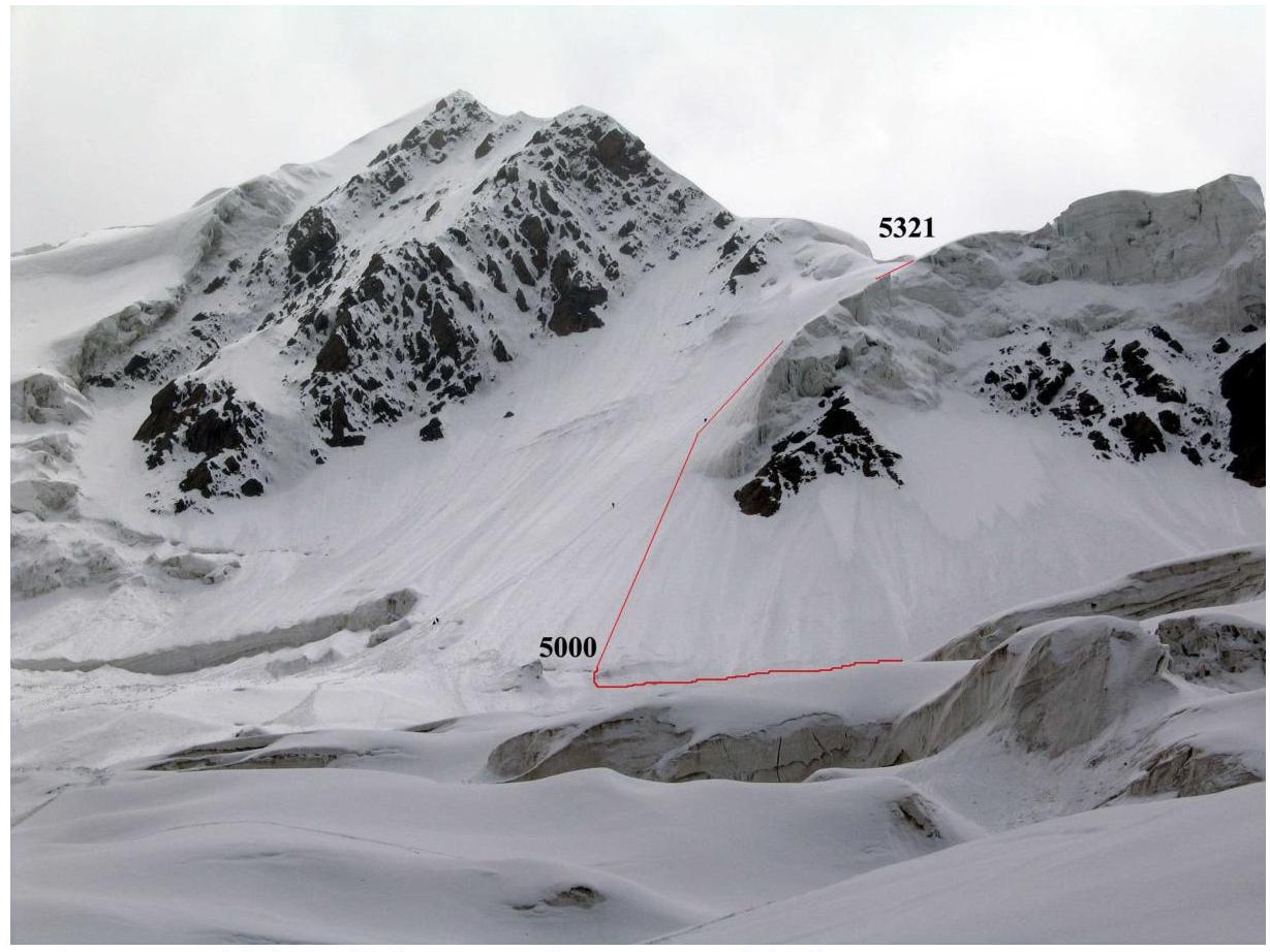
| R3 | Traverse of sn-ice slope | 4658 | 5000 | 2 | 3 | 686 | 30 |
| R4 | Ice slope | 5000 | 5300 | 3 | 4 | 425 | 45 (50° 200 m) |
| R5 | Snow plateau | 5300 | 5321 | 0 | 1 | 191 | 6 |
| R6 | Shelf | 5321 | 5515 | 1 | 2 | 449 | 26 |
| R7 | Traverse of 55-degree sn-ice slope | 5515 | 5533 | 4 | 5 | 50 | 20 on ascent, 55° across |
| R8 | Snow slope ascent | 5533 | 5650 | 2 | 3 | 190 | 38 |
| R9 | Snow slope | 5650 | 5767 | 1 | 2 | 285 | 24 |
| R10 | Wide sn ridge | 5767 | 5857 | 1 | 2 | 162 | 34 |
| R11 | Shelf to the right of the ridge | 5857 | 5920 | 1 | 2 | 169 | 18 |
| R12 | Icefall | 5920 | 6045 | 3–4 | 4–5 | 160 | 51 (three sheer walls 8–12 m, 6 category of difficulty) |
| R13 | Inclined sn plateau | 6045 | 6391 | 1 | 3 | 853 | 24 |
| R14 | Sn-ice slope | 6391 | 6640 | 3 | 5 | 375 | 45 (50° 150 m) |
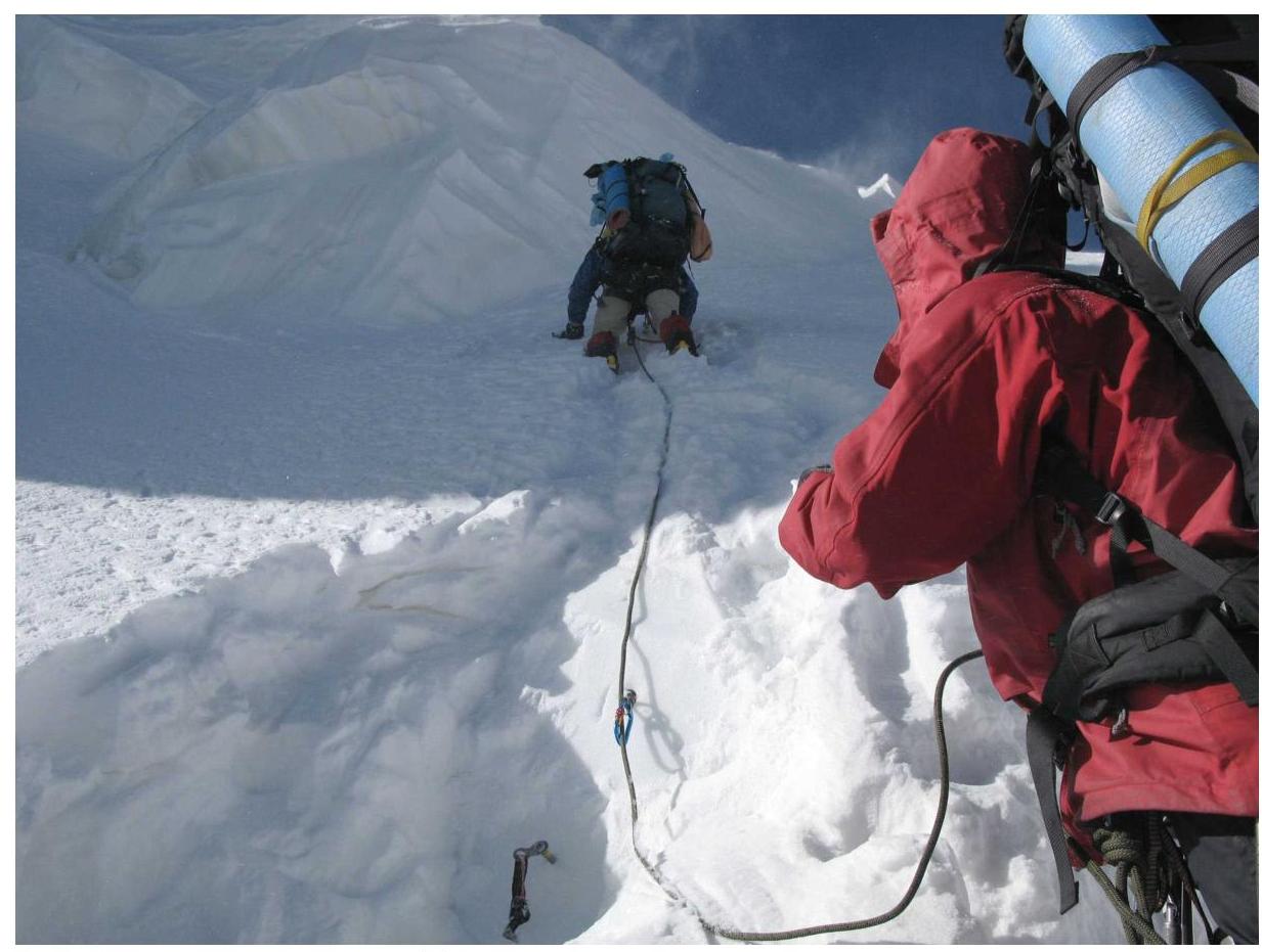
| R15 | Mixed (rocks frozen in ice) | 6640 | 6740 | 4 | 6 | 117 | 59 |
| R16 | Sn-ice slope-gully | 6740 | 6850 | 3 | 5 | 149 | 48 |
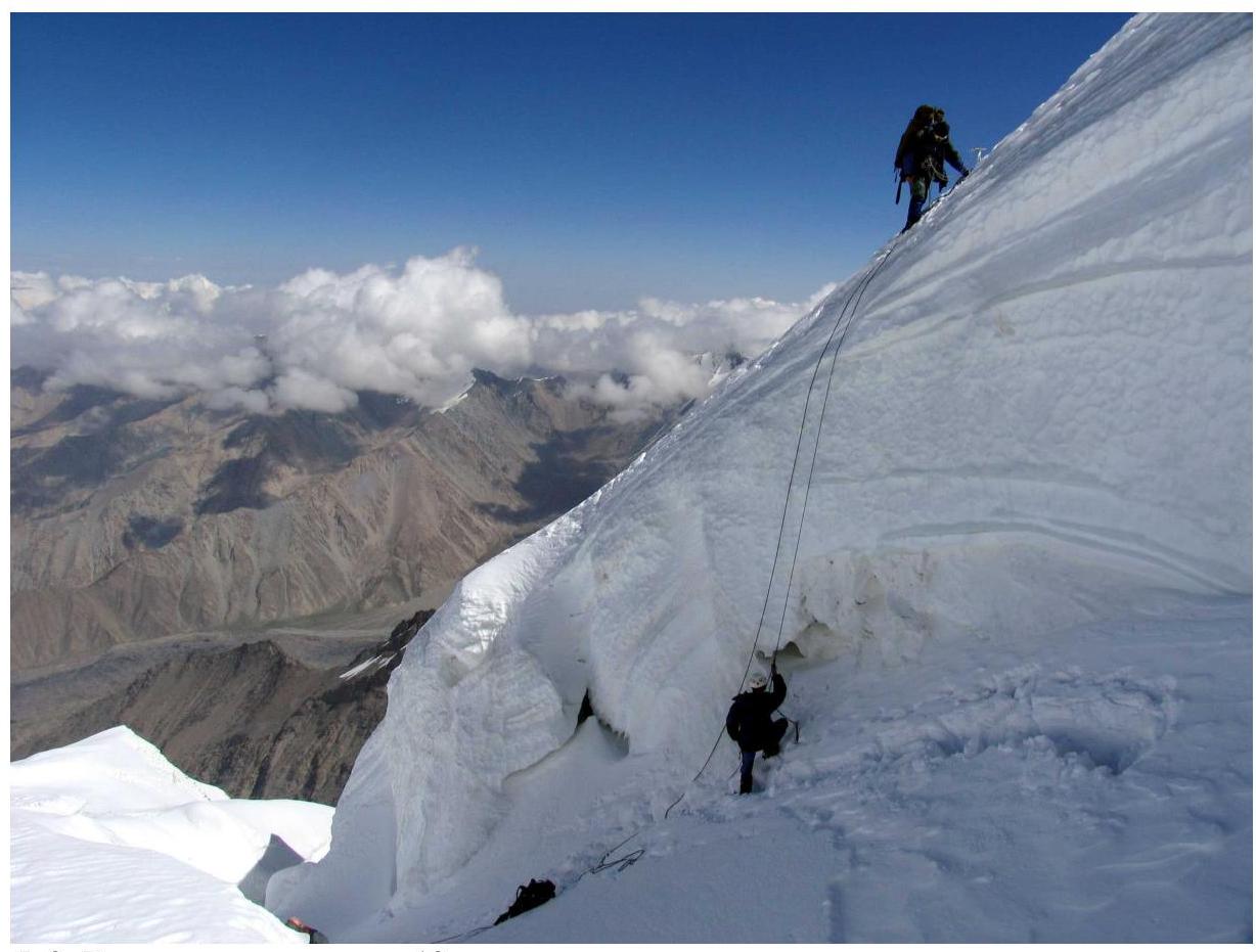
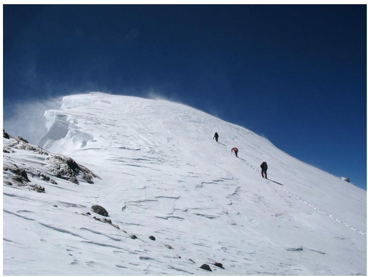
| R17 | Snow slope | 6850 | 7151 | 2 | 4 | 424 | 45 |
| R18 | Snow slope | 7151 | 7320 | 2 | 4 | 327 | 31 |
| R19 | Ice slope ascent | 7320 | 7480 | 3 | 5 | 248 | 40 |
| R20 | Snow slope | 7480 | 7640 | 2 | 4 | 284 | 34 |
| R21 | Wide sn ridge | 7640 | 7719 | 1 | 4 | 165 | 28 |
| 7287 |
Average slope of the route — 33.4°. Average slope of the upper part of the route (6391–7719, sections R14–R21) is 40.5°.
Total length of the route – 7287 m Length of the upper part of the route (6391–7719, sections R14–R21) is 2089 m.
Total length of sections with 5 category of difficulty — 822 m Total length of sections with 6 category of difficulty — 145 m
11. Technical Photograph of the Route
11.1. Lower part of the route to camp 2 (sections R1–R5)
Numbers indicate the ends of corresponding sections. Green circles — camps on the ascent, lilac — on the descent. Taken in August 2003 from the moraine of the Karayaylak glacier.
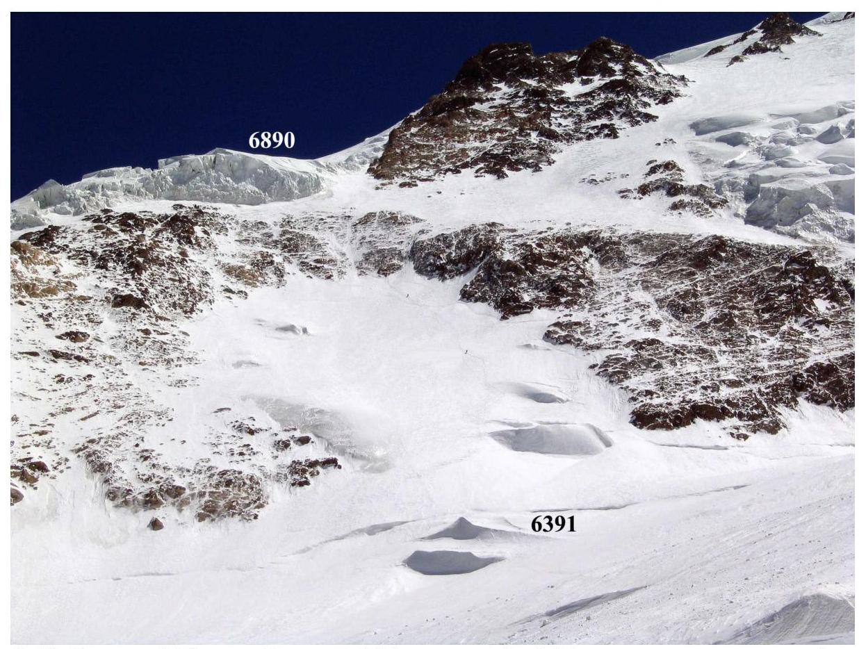
11.2. Upper part of the route (sections R13–R21)
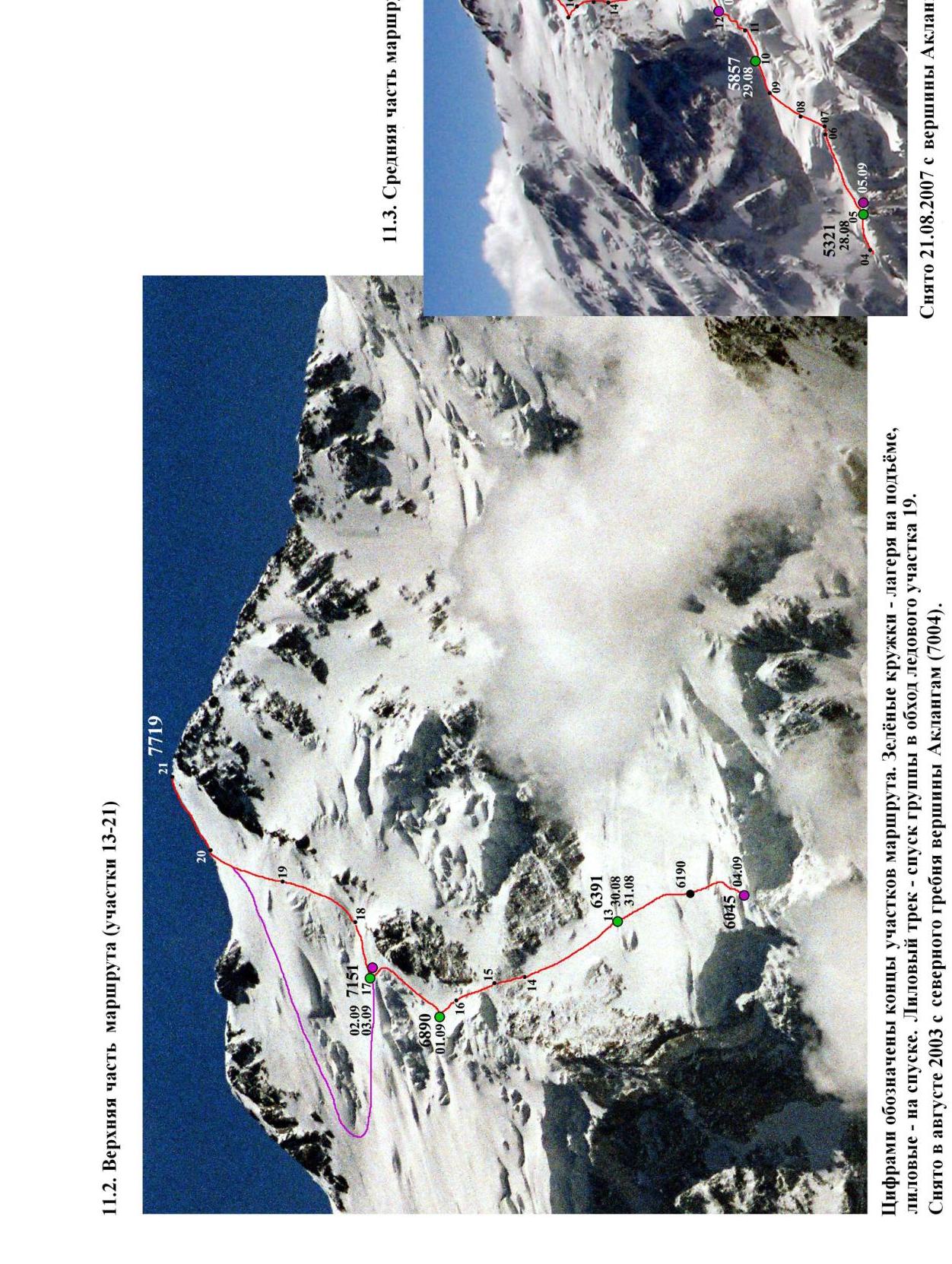
11.3. Middle part of the route (sections R6–R12) Numbers indicate the ends of sections. Green circles — camps on the ascent, lilac — on the descent. Lilac track — group's descent bypassing ice section R19. Taken on August 21, 2007, from the summit of Akalangam (7004).
12. Photo Illustrations
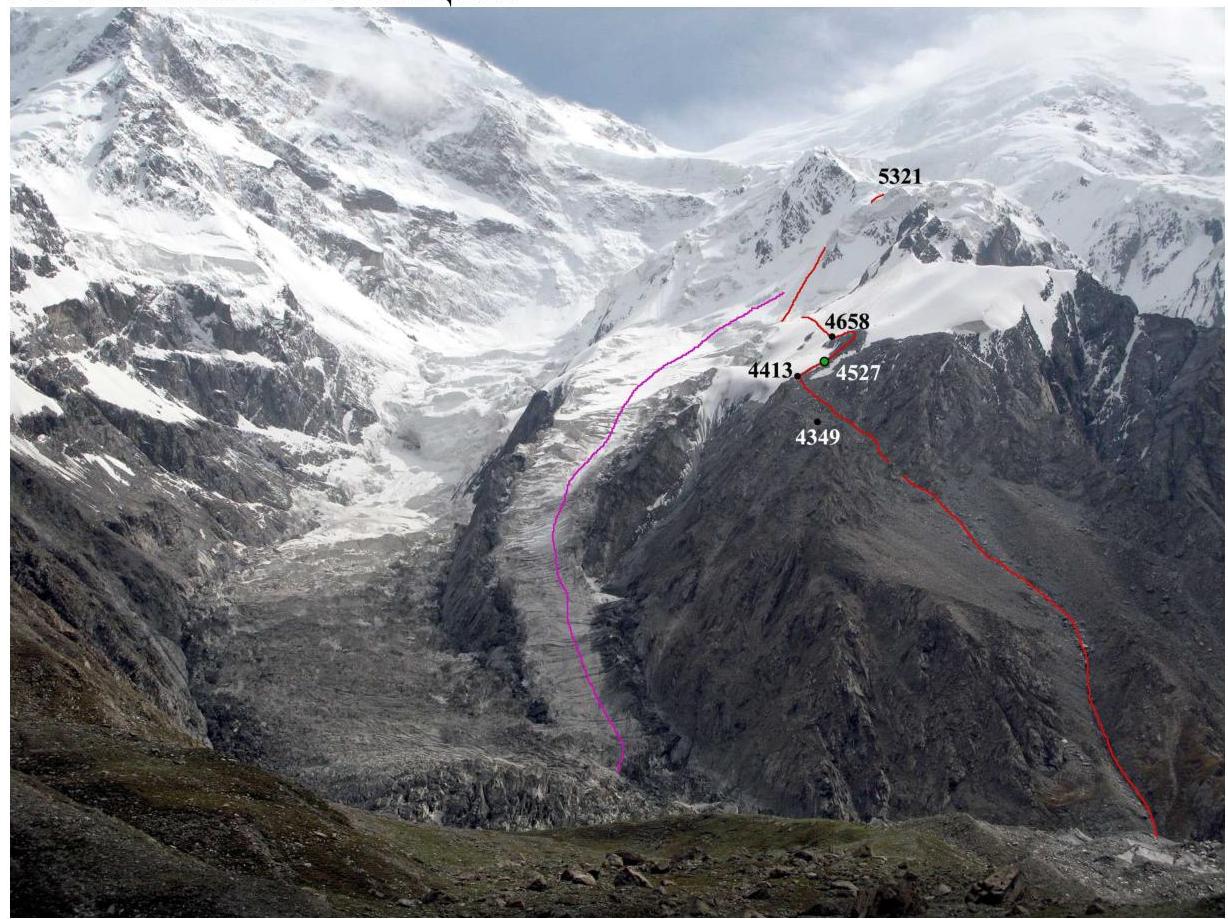 F.1. Sections R1 (up to 4413 m) and R2 (up to 4658 m). On the left — lilac track of Russian teams in 2004. The team's path through the gully eliminates problems with avalanche danger for C1. A safe camp can be set up in three places:
- at point 4349 m
- at point 4527 m (where it was implemented)
- at point 4658 m (especially convenient sites).
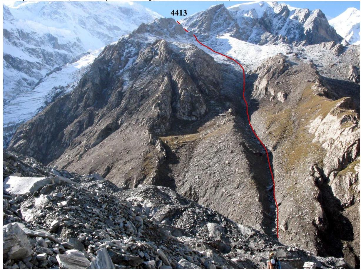 F.2. Section R1
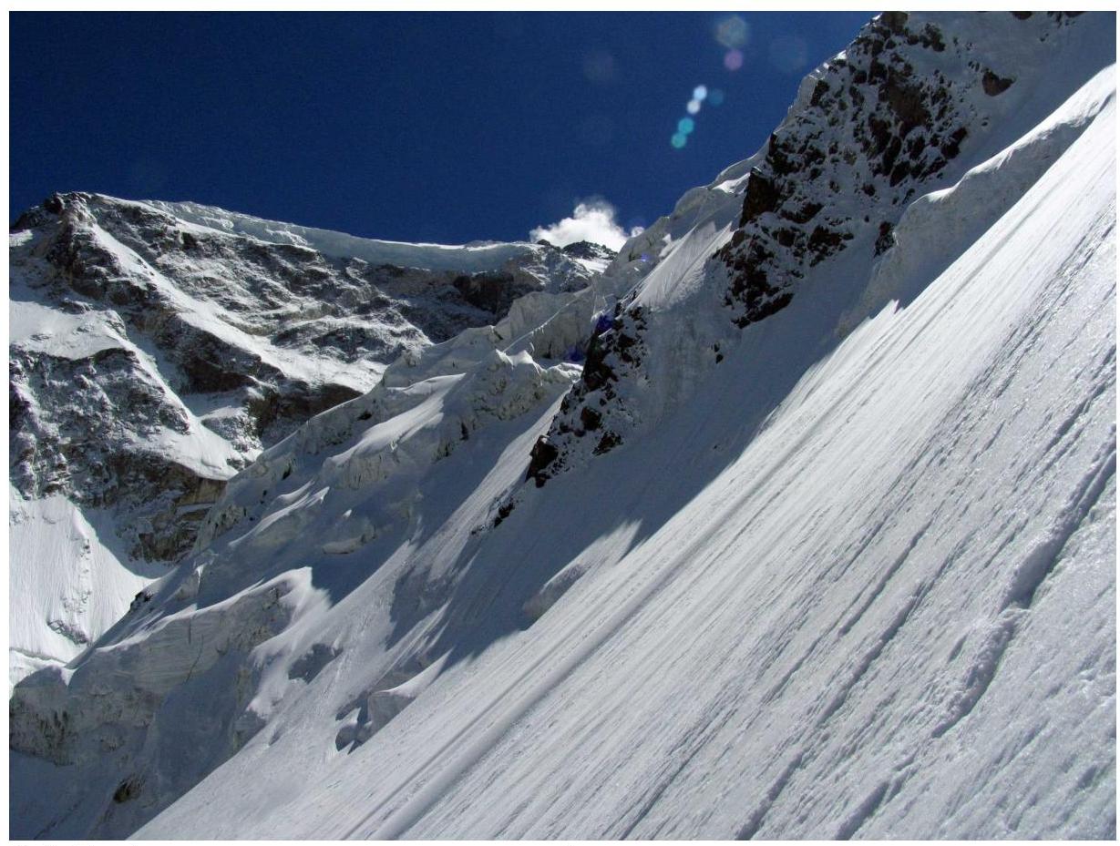
 F.3. On section R3. Ahead is section R4 (5000–5321).
 F.4. Section R4 (5000–5321). Photo by V. Odokhovsky (2004).
 F.5. Profile of the ice slope on section R4.
 F.6. On section R6.
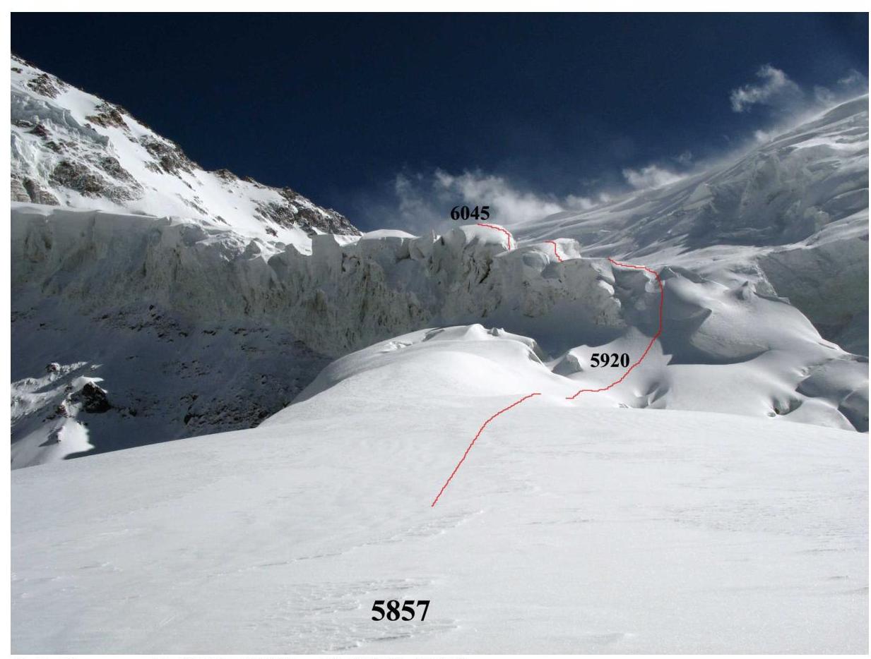 F.7. Sections R11 (5857–5920) and R12 (5920–6045).
 F.8. In the icefall on section R12.
 F.9. In the icefall on section R12.
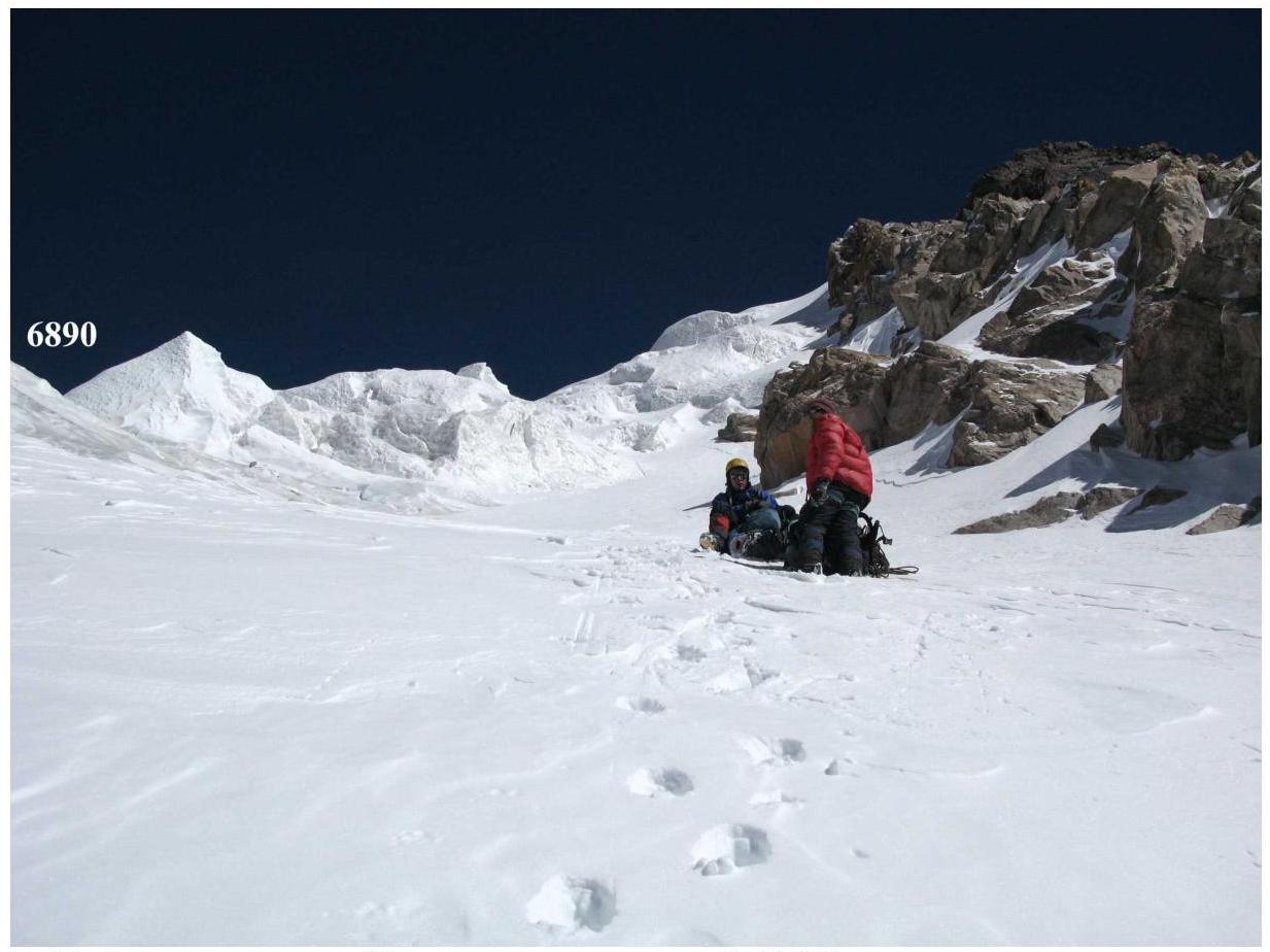
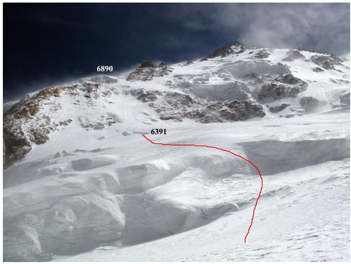 F.10. Path to camp R4 (6391), section R13.
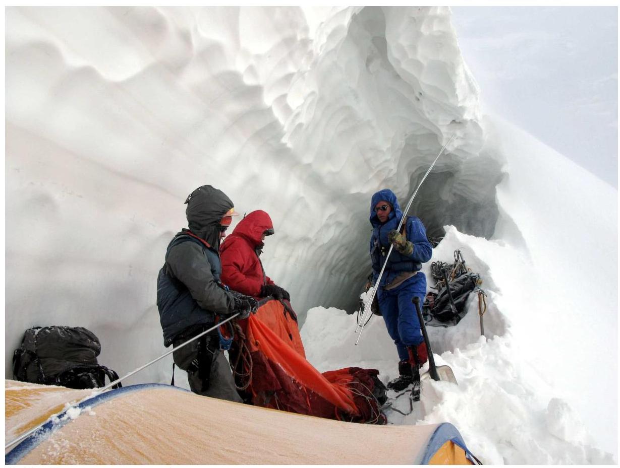 F.11. Rest day in camp R4 allowed us to wait out the bad weather, regain strength, and ensure that nothing was falling from the slope (from sections R14–R16).
 F.12. In camp R4. Training for setting a Guinness record.
 F.13. Sections R14 (ice slope), R15 (mixed zone), and R16 (gully above the mixed zone). Photo by V. Odokhovsky (2004).
 F.14. On the mixed zone (section R15).
 F.15. In the upper part of section R15, the group moved along a snowy strip. In the lower part, this is impossible; the snow is very loose. There, they moved along rocky outcrops.
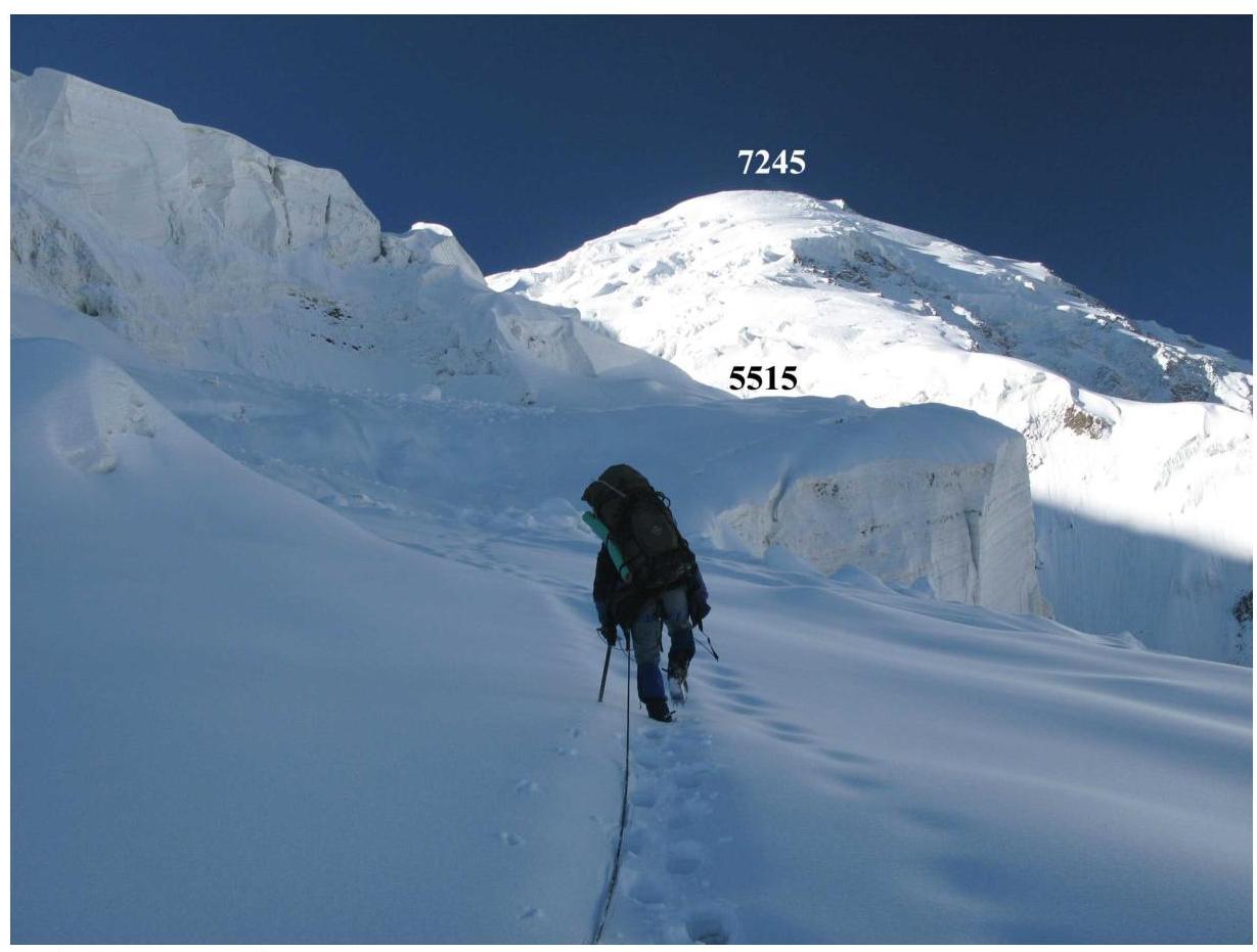
 F.16. At the start of section R17 when approaching camp R5 (6890).
 F.17. The morning of the assault day greeted us with strong winds. On section R18.
 F.18. On section R19.
 F.19. Reaching the ridge, section R20.
 F.20. On section R21.
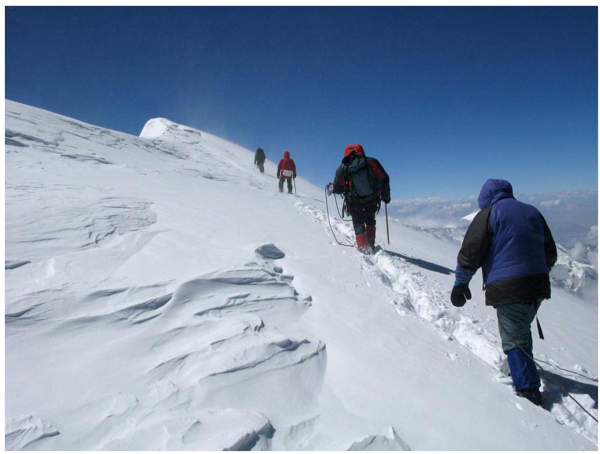 F.21. Last meters on section R21.
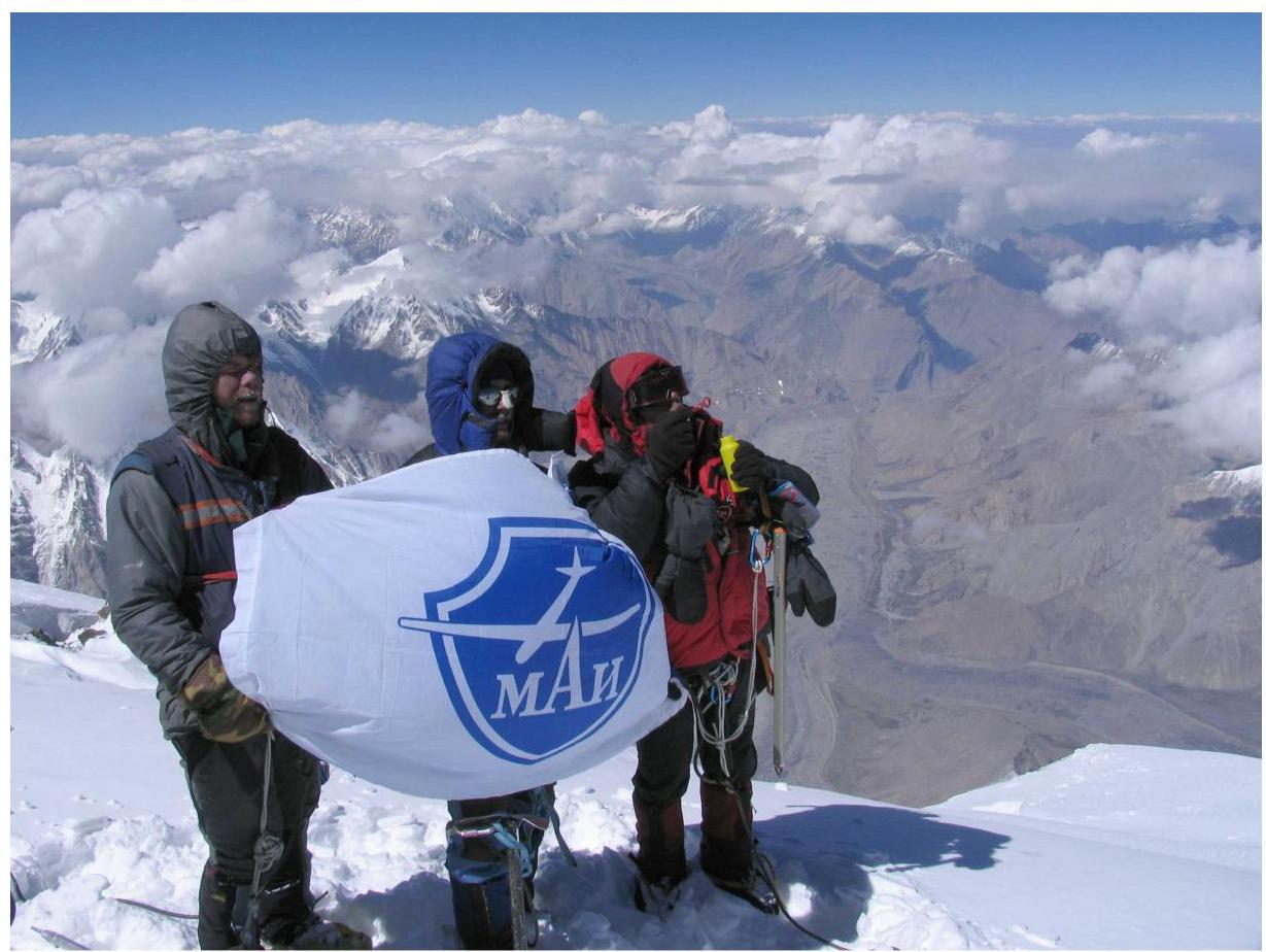
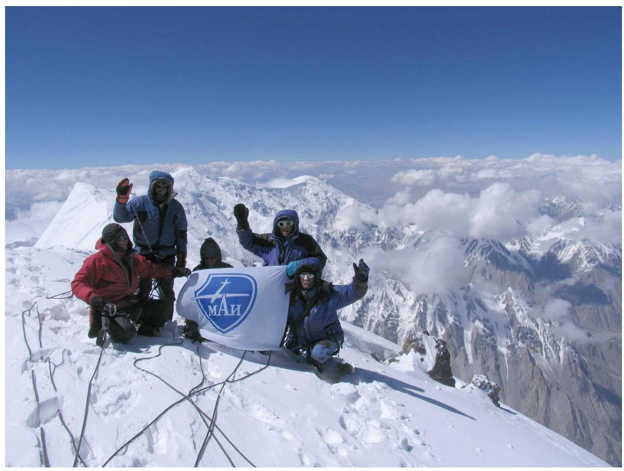 F.22. On the summit of Kongur. Photo by A. Timoshenkov.
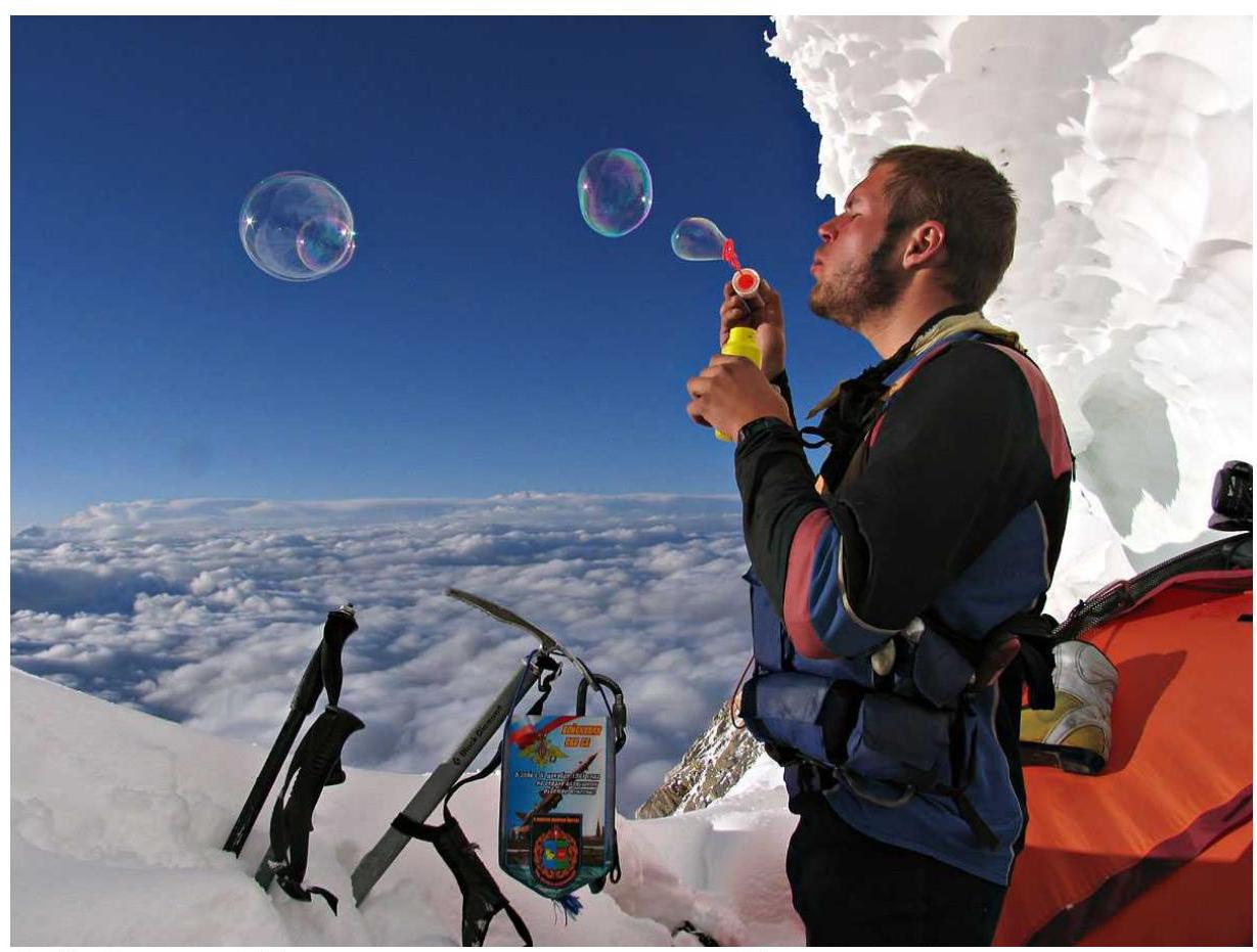
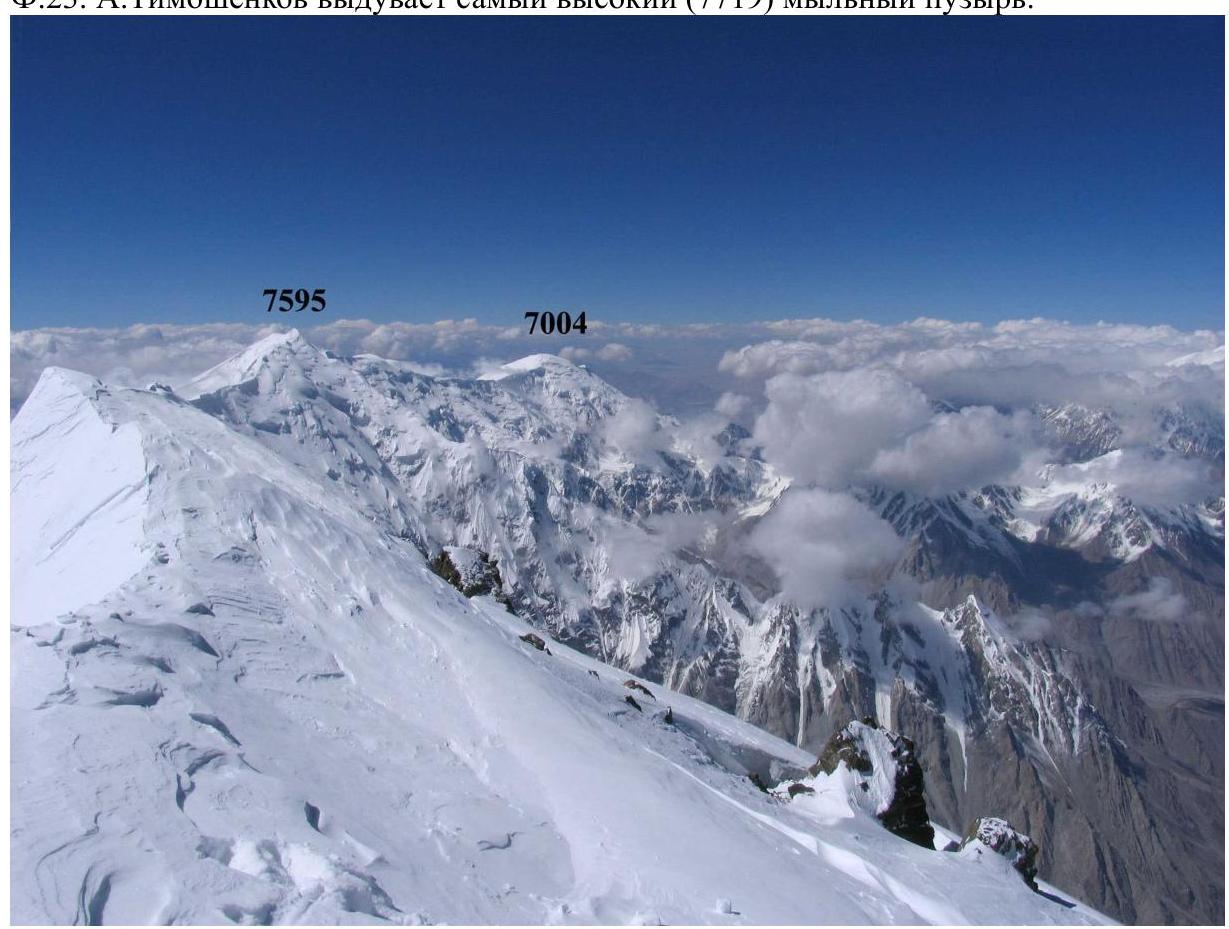
 F.23. A. Timoshenkov blows the highest (7719) soap bubble.
 F.24. Characteristic rocky outcrops on the northern slope of the western ridge.
13. References
- A. Lebedev. Report on a mountain trip to Chinese Pamir with an ascent to Kongur. http://static.turclubmai.ru/papers/1495/ ↗
Appendix
On September 4, during the descent from the summit of Kongur, not reaching camp R3 at an altitude of ~6190 m (this place is marked with a black circle on the technical photograph of the route 11.2), Sergey Bezditko suffered a stroke. The rescue operation is reflected in the following publication.
Information Message from the Route-Qualification Commission of the Central Tourism Section of MAI on the Rescue Operation on Kongur Peak (PRC, Xinjiang Uyghur Autonomous Region) September 4–8, 2007
From July 25 to September 8, 2007, a group of tourists from the sports club of the Moscow Aviation Institute, led by multiple Russian champion Andrey Lebedev, born in 1956, Master of Sports of International Class, undertook a 6th category of difficulty mountain trip along the Chinese Pamir, with a total distance of over 330 km.
On the final stage of the route, around 15:00 local time on September 3, the group of 6 participants completed an ascent to the highest point of the Pamir — Kongur Peak (7719).
After descending from the summit and overnighting in the assault camp "7150", the group began moving down the northern ridge of Kongur towards the Karayaylak glacier on the morning of September 4. In the afternoon of September 4, when approaching camp "6000" at an altitude of about 6200 m, group member MSMS Sergey Bezditko, born in 1959, felt severe discomfort and lost the ability to move independently. Based on the observed symptoms — temporary loss of consciousness and partial paralysis — other participants diagnosed a stroke.
During the morning communication session on September 5, the group leader reported via satellite phone to the Route-Qualification Commission of the Central Tourism Section of MAI about the emergency situation.
MKK members contacted the Chinese tourist guide Zhang Hong (Russian name — Sasha), who had assisted the MAI tourist club team in organizing the trip. At Zhang Hong's disposal, actions were taken to ensure the transportation of the injured person from the Karayaylak glacier to a populated area:
- On the morning of September 6, a local resident named Abbas was sent from the Göz village to the base camp "3600" at the foot of Kongur with pack animals.
- Transport was reserved for the group's departure from Göz.
- Accommodation was booked for them in Kashgar.
In parallel with the organization of assistance through non-state channels, by the evening of September 6, an appeal was prepared and sent to the Ministry of Foreign Affairs of the Russian Federation on behalf of the Tourist-Sporting Union of Russia, requesting the evacuation of the ill participant of the MAI tourist group, S. Bezditko, based on which the Russian Embassy in Beijing made an official request to the authorities of the People's Republic of China.
The Chinese state bodies promptly took a set of measures to ensure the evacuation of the injured person. A specialized ambulance vehicle was sent to the Göz village, accompanied by officials and border troops; a helicopter with a crew was on standby at Urumqi airport from the morning of September 8; and a team of the best neurosurgeons of the Xinjiang Uyghur Autonomous Region was delivered to
Comments
Sign in to leave a comment