
11
Central Asia
Mountain range3,552,051.21 km²
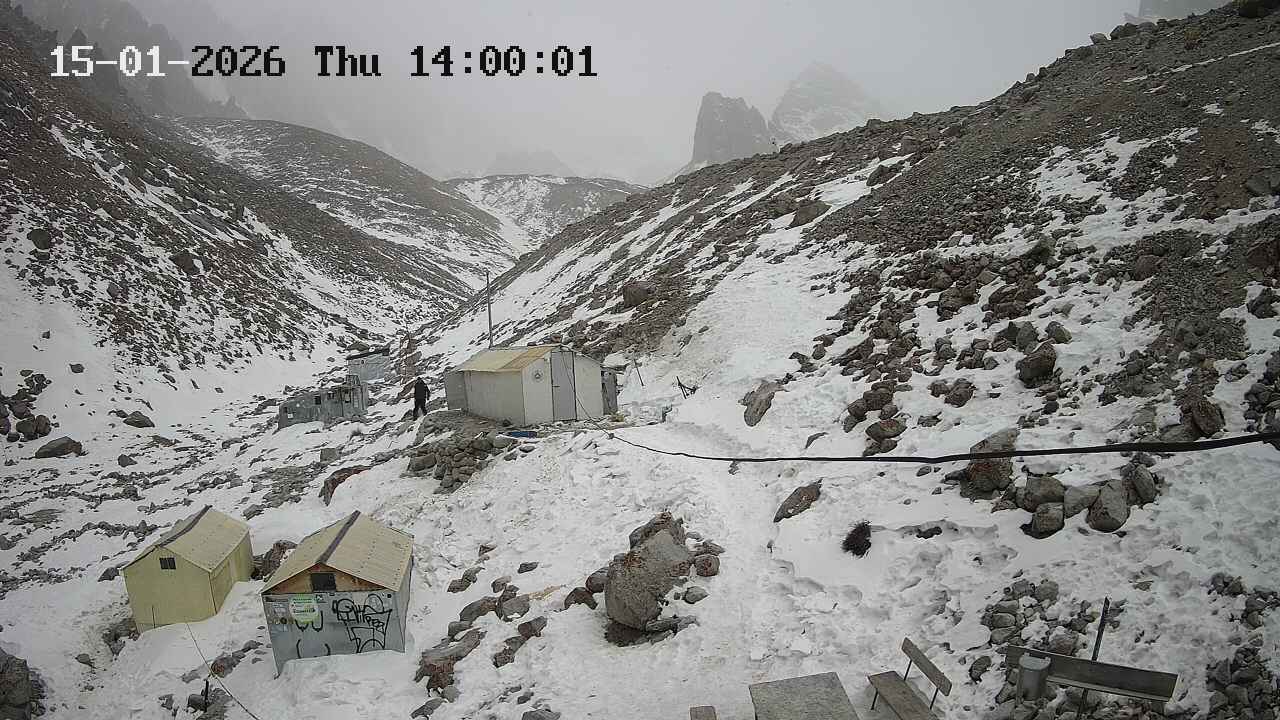
New alpine route: Markevich' cascade
 ELEvgenii Lepikhin
Difficulty:5Б / TD
Route type:Mixed
Maximum elevation:
4810 mPasses through:Korona Peak
Kyrgyzstan → Uchitel glacier and Korona ridge area
In autumn 2025, two ice streams formed on the northern wall of Pik Korona. The first ascent of the right stream (rated 5A in the Russian classification) was made by Aleksandr Parfyonov's team in early 2026. The first ascent of the left stream was made by Konstantin Markevich with Aleksey Pototskiy in the second half of March 2026. Further, according to Aleksey:
Last year was very hot in July. And as a result of this circumstance, two new routes formed on the northern wall of Pik Korona. The charm of these routes is that this year or next, such conditions may not happen, and these routes may not exist. But while they are there - we have to climb 😁 And we did. One route was climbed by Parfyonov with a partner in February, and the second one - Kostya Markevich and I last week.
Honest 5B and this is the coolest ice in the area. The icicle itself is 170 m of 87-degree lace cascade ice. And before that, there's another 30 meters of A3 ice climbing. The lower part is 450 m of gentle ice at 55-70 degrees.
 Loading video...
Work on the route

The Best Month for Ala-Archa
ELEvgenii Lepikhin
Weather in Ala Archa National Park by month: temperature, stability, precipitation, and safety recommendations for climbers.
People often ask about the weather in Ala-Archa, when the best season is, and when it's safe to ice climb. I've decided to put this information into a micro-article.
January
 Stable weather, many sunny days, often calm. The temperature at Ratschek hut is -10 to -20°C with rare deviations from this range. However, there's only 2 hours of sunlight per day, not enough to warm up.
February
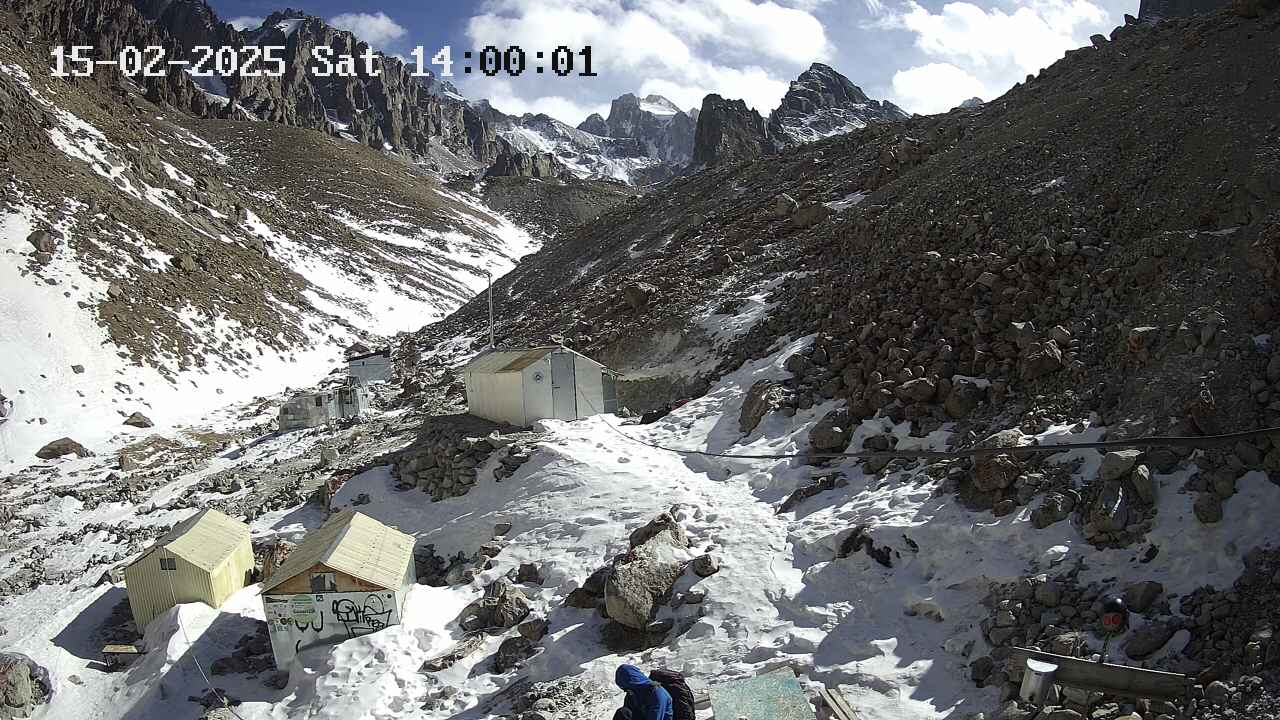 Almost like January, but towards the end of the month, stability is lost – March is approaching.
March
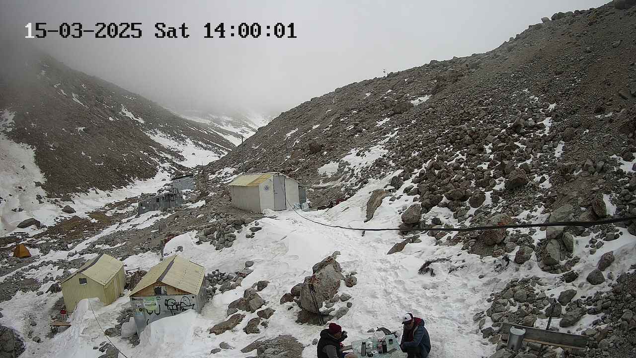 Very unstable weather. Stormy winds can last for 2 consecutive days, and fog can hang for 2 weeks. Heavy snowfalls are rare but possible. On good days, even in early March, it's sometimes possible to walk in a T-shirt when the sun is out. Daytime temperatures range from -10 to +5°C.
April
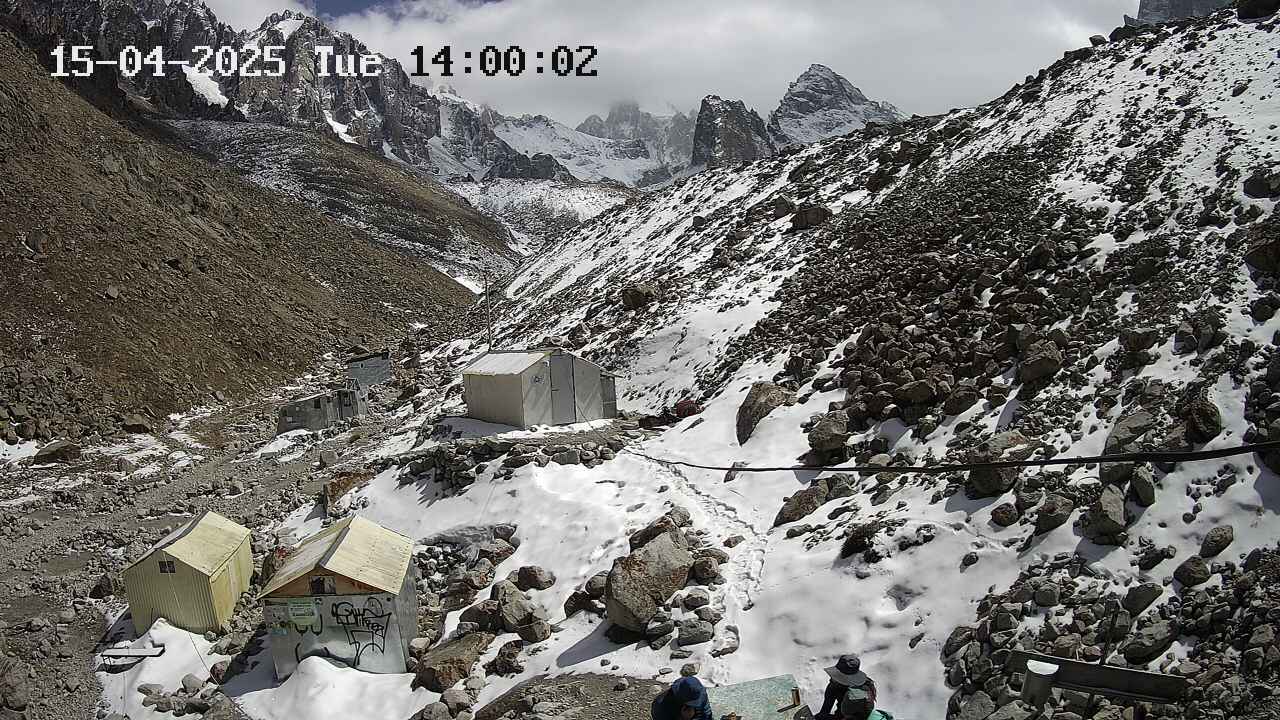 The same March winds, but it gets warmer.
May
6
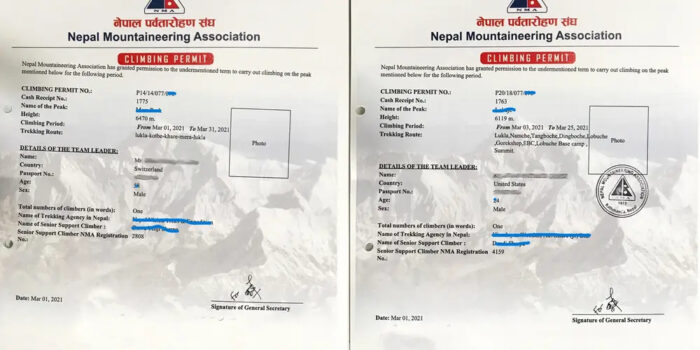
0Nepal: Obtaining Permit for Solo Ascent in Restricted Areas
ELEvgenii Lepikhin
Opportunities for solo ascents of unclimbed peaks in Nepal, permit regulations, and new summits open to alpinism in 2024.
A query from a reader (ExplorersWeb's reader — editor's note) planning a trip to Upper Mustang drew our attention to the hurdles independent climbers face when planning their Himalayan projects, especially solo ascents or attempts on unclimbed peaks in restricted areas. We reached out to a Nepalese tour operator for clarification on obtaining such permits.
Q&A
Matt Powell from the US asked:
I was hoping you could provide me with some clarification regarding Nepal's rules for solo climbers, particularly in restricted areas such as Upper Mustang and the Nar Phu valley. Is it possible for a single climber (myself) to obtain a permit to climb a peak in a restricted area if I use the services of a Nepalese guide? And if so, how do I go about it? Dawa Stephen Sherpa clarified that it is possible. However, he added, the climber must obtain the permit through a registered and certified trekking agency in Nepal. The main question, however, lies in what permits the climber needs and what are the requirements for each. It turns out that it depends on the height of the peak and involves various permits and procedures.
Expedition Peaks
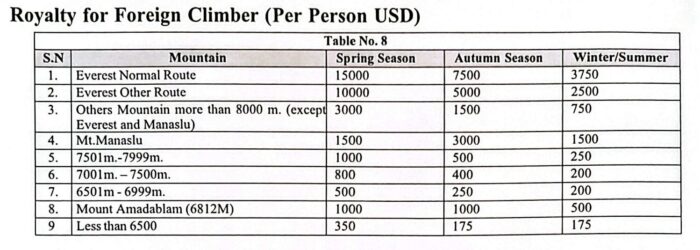
Peaks above 6,500 m are considered expedition peaks and require a permit and the presence of a sirdar/guide and liaison officer on the expedition, increasing the cost. Permits for these peaks are issued by the Department of Tourism, under the Ministry of Culture, Tourism, and Civil Aviation of Nepal.
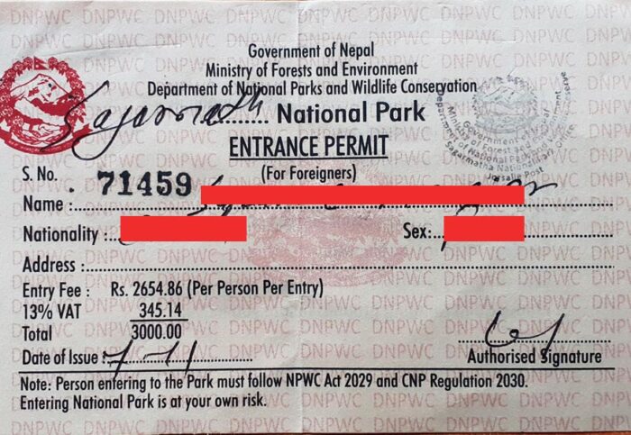 Once the climber has paid for the permit, the agency receives a letter from the Department of Tourism, which must be presented to the immigration department, issuing a second permit: the Restricted Area Permit (RAP). This allows the climber to enter the restricted zone at no additional cost, since they have already paid for the climbing permit.
6
0Climbing Mera Peak and Trek to Ama Dablam
ELEvgenii LepikhinSasha Moroz shares his experience on the trek to Mera Peak and the summit ascent, and talks about his further plans to climb the west face.
In a beautiful video, Sasha Moroz describes his impressions of Nepal, and also talks in detail about the trek to Mera Peak via the pass https://summitx.info/ru/objects/passes/12617730/about, and the ascent to the summit. Further plans include climbing https://summitx.info/ru/objects/peaks/12763468/about via the American Direct route on the west wall.
Loading video...
9
0Nepal: Climbing Everest Only After 7,000 Meters
ELEvgenii Lepikhin
Nepal introduces new rules for climbing Everest: climbers must first ascend a 7,000-meter peak in Nepal to prevent inexperienced climbers from attempting the ascent.
New Everest Climbing Regulations: Climbing a 7,000-meter Peak in Nepal First is Now Mandatory
 Nepal's National Assembly has passed a new tourism bill that requires climbers to first ascend a 7,000-meter peak in Nepal before tackling Everest. This new regulation aims to deter inexperienced or unprepared climbers from attempting the mountain and to develop the expedition business in the country.
Every year, new regulations are proposed for trekking and mountaineering in Nepal, and now they are on the verge of becoming national law. The requirement for climbers to have prior experience ascending a 7,000-meter peak in Nepal before attempting Everest is the most notable innovation.
Nepal's National Assembly has passed a new tourism bill that requires climbers to first ascend a 7,000-meter peak in Nepal before tackling Everest. This new regulation aims to deter inexperienced or unprepared climbers from attempting the mountain and to develop the expedition business in the country.
Every year, new regulations are proposed for trekking and mountaineering in Nepal, and now they are on the verge of becoming national law. The requirement for climbers to have prior experience ascending a 7,000-meter peak in Nepal before attempting Everest is the most notable innovation.
 According to officials, this provision is designed to curb the growing number of inexperienced climbers attempting the world's highest peak, which often leads to congestion, accidents, and strain on rescue services. Nepal has 86 peaks between 7,000 and 7,999 meters, and the climbing fee for foreigners ranges from 500to800 during the spring season.
Some of the rules outlined in the bill have also featured in other recent ordinances, such as the requirement to provide a recent medical certificate to obtain a climbing permit. The bill also lays the groundwork for a general environmental fund that will collect money from climbers.
According to officials, this provision is designed to curb the growing number of inexperienced climbers attempting the world's highest peak, which often leads to congestion, accidents, and strain on rescue services. Nepal has 86 peaks between 7,000 and 7,999 meters, and the climbing fee for foreigners ranges from 500to800 during the spring season.
Some of the rules outlined in the bill have also featured in other recent ordinances, such as the requirement to provide a recent medical certificate to obtain a climbing permit. The bill also lays the groundwork for a general environmental fund that will collect money from climbers.
5
0Everest: Statistics and Facts of the 2026 Season
ELEvgenii Lepikhin### Everest Statistics as of December 2025 - **Total Ascents:** 13,737 - **Total Deaths:** 339 - Notable trends include a steady **increase in climbers** and **fatalities** - The role of **supplemental oxygen** and **Sherpa support** is significant.
Overall Statistics (as of December 2025)
As of December 2025, there have been 13,737 summits of Everest, corresponding to a 43% success rate. Of those who reached the summit, 7,563 different people have stood on the top. 339 people have died on all routes. Nepal remains the more popular and more deadly side. 9,887 summits and 229 deaths were recorded on the Nepalese side, corresponding to a death rate of approximately 2.3%. On the Tibetan side, there were 3,850 summits and 110 deaths, a death rate of 2.8%. The use of supplemental oxygen remains one of the strongest predictors of survival. 180 of the 339 deaths occurred among climbers ascending without supplemental oxygen.
Tibet or Nepal?
The Nepalese side remains the most popular route and has recorded the highest absolute number of fatalities. The Tibetan side has recorded a slightly higher percentage of deaths — 2.8%, but a comparable normalized mortality rate — 1.05.
Deaths Rise with the Number of Climbers
Since 2000, Everest has experienced an unprecedented influx of climbers. 15,781 people climbed above Base Camp in Nepal from 2000 to 2025, nearly triple the total number for the previous 80 years. Throughout Everest's history (1921–2025), 339 people have died on the mountain. The average number of deaths increased to approximately seven deaths per year from 2010 to 2025.
Standard Routes — 98% vs. Non-Standard Routes — 2%
5
0New alpine route: Fedorov
ELEvgenii LepikhinDifficulty:4А / D-
Route type:Ice
Maximum elevation:
4810 mPasses through:Korona Peak
Kyrgyzstan → Uchitel glacier and Korona ridge area
One of the most popular routes to the Corona peak crest wall. It starts from the bergschrund, from which there are about 450 meters of even ice to the ridge. On the penultimate rope of the route, there is a small ice ridge, which is a bit more complicated than the main section of the route. The start of the route is 70-100 meters to the right of the https://summitx.info/en/routes/58844837/about route. In the Russian official classification, both these routes are considered variants of the same route.
22
Video Guide to "Mobilnye" Route (5A) on Korona by Dima Pavlenko
ELEvgenii LepikhinVideo guide to the "Мобильных" route (5A) to the first Korona tower by experienced alpinist Dima Pavlenko.
Video guide to the "Мобильных" route (5A) on the first tower of the Crown by Dima Pavlenko.
Loading video...
21
0Pavlenko's Video Guide: 3A to the first tower of the Crown
ELEvgenii LepikhinVideo guide to the 3A route to the first tower of the Crown by experienced alpinist Dima Pavlenko.
Video guide for the 3A route to the first tower of the Crown by Dima Pavlenko.
Loading video...
17
0Pavlenko's Video Guide: "Rechki" Key, 4B on Mt.Baychechekhey
ELEvgenii LepikhinVideo guide to the "Rechka" route (4B ice climbing grade) on Pik Baychechekhey with a demonstration of climbing the key wall.
Video guide to the "Rechka" route (Ilyushenko, ice 4B) on Peak Baychechekey by Dima Pavlenko. Captured work on the key wall.
Loading video...
40
0Showing 1–10 of 2380 results