14
0Activity Feed
Pavlenko's Video Guide: Barber's Route 5B on Svobodnaya Korona
 ELEvgenii Lepikhin
Video guide to the Barbar route (5B, ice climbing) on Peak Svobodnaya Korona by experienced mountaineer Dima Pavlenko.
Video guide for the Barbera Route (5B, ice climbing) on Pik Svobodnoy Korei by Dima Pavlenko.
Loading video...
Pavlenko's Video Guide: Balezina Right Route 5B on Svobodnaya Kornya
ELEvgenii LepikhinVideo guide to climbing Balezin's Right Route (5B cat.) on Peak Svobodnaya Koreya with experienced mountaineer Dima Pavlenko.
Video guide of the Balezin's right route (5B) on Peak Svobodnaya Koreya by Dima Pavlenko.
Loading video...
14
0Website Updates – Part 1
ELEvgenii Lepikhin
Users of the site can now edit mountaineering routes, add descriptions and draw tracks on the map, as well as create new routes.
Now every user of the site can edit alpine routes and add their own.
- In addition to the impersonal official name "via the right couloir of the S wall", you can add a folk name that is known to everyone.
- You can draw a route thread, and it will be displayed on the map.
- Write a detailed description of the route, with pictures, etc. It is important not to confuse this with reports and articles. This is precisely a general description of the route. An example of a more or less edited route: https://summitx.info/ru/routes/58844991/about
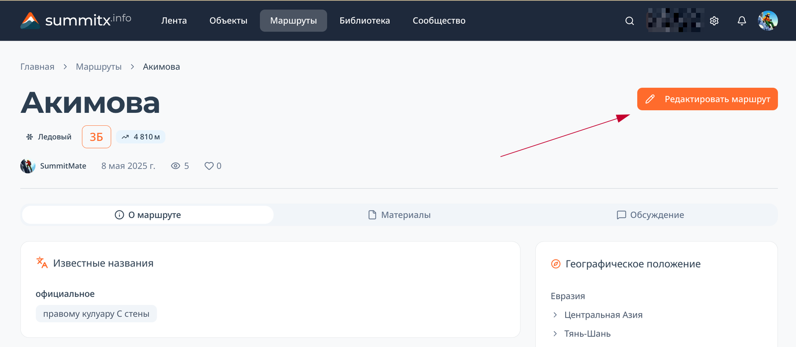
How to edit a route
Click the edit button on the route page:
 You will be taken to the draft edits page. The draft can be saved and you can return to editing it later using the same button, or from your personal account.
To draw or edit a route line, on the card with the map, you need to click the edit button (1), after which you can simply click on the map to add, delete or move points:
You will be taken to the draft edits page. The draft can be saved and you can return to editing it later using the same button, or from your personal account.
To draw or edit a route line, on the card with the map, you need to click the edit button (1), after which you can simply click on the map to add, delete or move points:
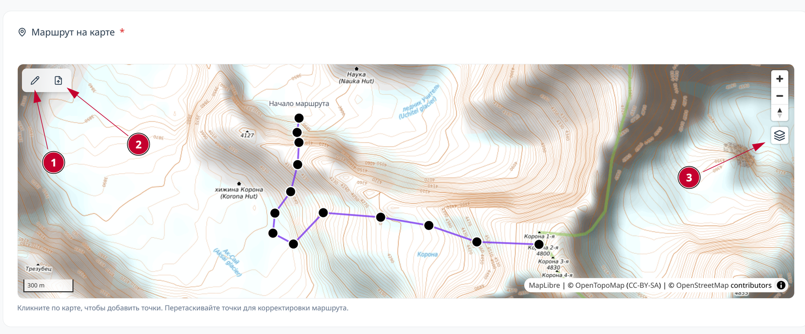 By the way, take a look at the other buttons:
12
1Route Description: ЮЗ гребню
 SSummitMate
Technical ascent to the summit "Bezimyannaya" (4050 m) along the south-west ridge, complexity category - 3, height difference 1300 m, duration of the route 10-12 hours.
Passport
Ascent to the "Bezымянная" peak via the southwest ridge
- Class of ascent — technical.
- Area of ascent — Caucasus, Bezengi area, southwest spur of Dykh-Tau (Fig. 1).
- "Bezымянная" peak 4050 m, in the spur of Dykh-Tau (Fig. 2).
- Proposed category — 3.
- Route characteristics: a) height difference — 1300 m; b) route length — 900–1100 m of snow-ice slope; c) average steepness — 35–45°.
12
0Route Description: ЮВ гребню с пер. Ак
SSummitMate
Description of the 1B alpinist route to the Ak-Tur Uzunkol summit via the Ak pass with detailed timing and characteristics of the route.
Aktur Uzunkol — description of the 1B alpinist route from SK Greta
Route description: The trail to Ak pass begins from the first tributary flowing into the Myrdy river below the first bridge from the top on the right bank, and leads left along the trail upwards along steep grassy slopes in the direction of the Pyramida peak.
After 1.5 hours, the slope becomes gentler, and the trail goes along small rocky-grassy terraces. 40 minutes later, on one of the terraces to the left of the trail, on a wonderful lawn thickly overgrown with grass, next to a crossing stream, there are good places for tents, no firewood. A couple of rocky-grassy ascents lead to the glacier flowing from under the Pyramida and Ak-bashi peaks.
We ascend to the glacier to the right along the trail via small and medium talus and snowfields and enter a small glacial cirque north of the Ak-bashi peak, ending with a ridge of heavily destroyed rocks. A small depression in the ridge is the Ak pass.
Orienting our movement towards the saddle of the pass, we cross the glacier and ascend to the pass via snow and then destroyed rocks.
From the pass, we ascend to the peak via a snowy (at the end of summer — talus) slope. Descent is via the ascent route.
Path chronometry:
- ascent to the tongue of the glacier — 3 hours;
- along the glacier to the pass — 1 hour;
11
0Route Description: С ребру
SSummitMate
Description of the ascent to the Eastern peak of Ak-Tyube mountain via routes of 1B and 2B difficulty categories with recommendations and details of the route passage.
GVANDRA PEAK – 3993 m
- Ascent to Gvandara East Peak from Ak-Tyube Pass – Cat. 1B
- Ascent to Gvandara East Peak via the northern edge from Ak-Tyube Glacier – Cat. 2B (Description of the route as you move towards the peak) Difficulties
- Ascent to Gvandara East Peak – Cat. 1B The path to the bivouac is described in the description of the Kara-Baschi peak. From the bivouac:
- straight across the moraine to the Morde Glacier;
11
0New features: direct video uploads to posts, a writing assistant for authors, a refreshed homepage, and an improved mobile experience.
Several useful features have been added to the website.
Video Uploads
 Previously, only links to external video services (YouTube, Vimeo, etc.) could be added to articles, descriptions, and comments. Now it is possible to upload small video clips directly to the website. The video will be embedded directly in the article, route description, or geographical object.
An example of a route description with video clips can be viewed in the description of the new Ala-Archa route: https://summitx.info/ru/routes/65022948/about
Previously, only links to external video services (YouTube, Vimeo, etc.) could be added to articles, descriptions, and comments. Now it is possible to upload small video clips directly to the website. The video will be embedded directly in the article, route description, or geographical object.
An example of a route description with video clips can be viewed in the description of the new Ala-Archa route: https://summitx.info/ru/routes/65022948/about
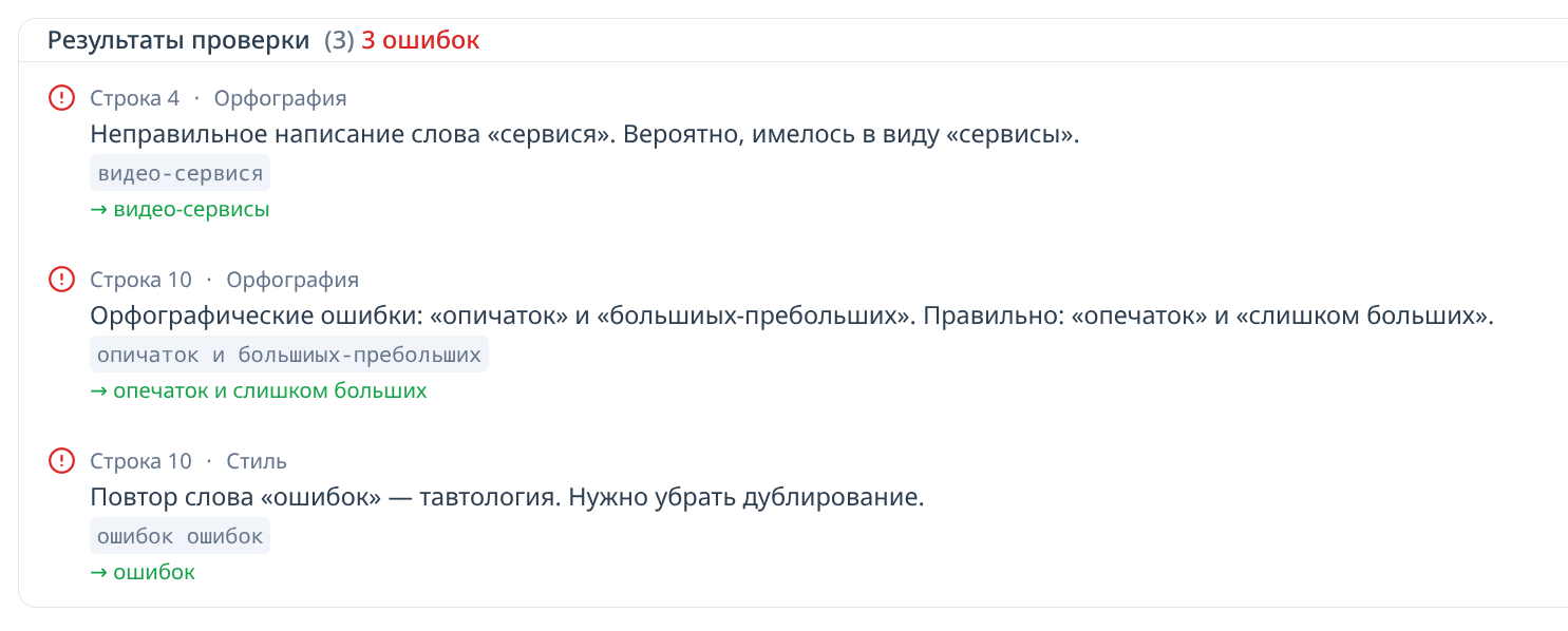
Writing Assistant
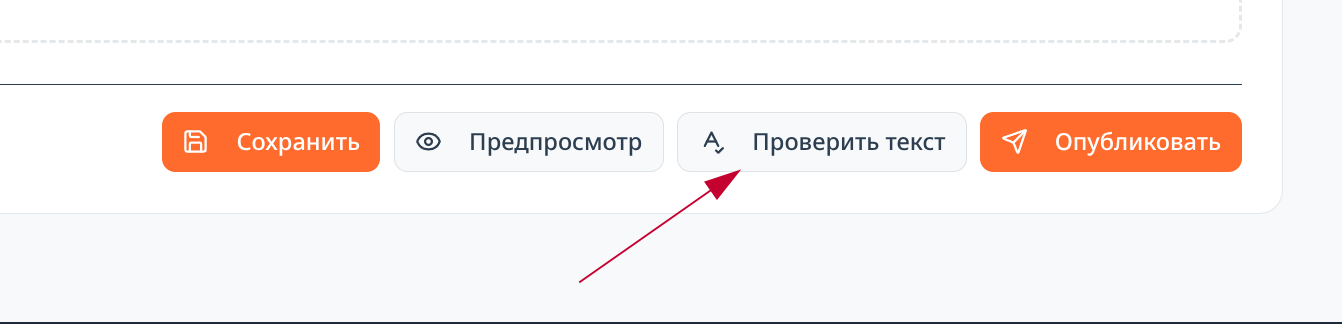 For article authors, the ability to check the quality of typed text has been added. This will help you write higher quality texts, without typos and errors. For example, here is what the assistant found in this article while it was being edited:
Other Improvements
- The main page has been redesigned. Instead of an article feed, it now contains summary information about the latest events on the website: articles, discussions, new routes, etc. New visitors will find it easier to navigate the portal's features. The article feed now lives on a separate page.
- Filters have become more compact in the mobile version of the website.
3
0Route Description: С склону и 3 гребню с пер. Марух
SSummitMate
Description of the first ascent of Marukh-kaya peak via the southern slope and western ridge, category 3A, with recommendations on equipment and itinerary.
PASSPORT
- Category — rock.
- Caucasus, Aksaut gorge.
- Marukh-kaya peak via the N slope and W ridge.
- Proposed — 3A cat. diff. (combined), first ascent.
- Height difference — 400 m, length — 650 m. Average steepness of the route — 35–40°.
- Pits were not left on the route.
- Climbing hours on the route — 8.
- Overnight stops — I (on Marukhkay pass).
10
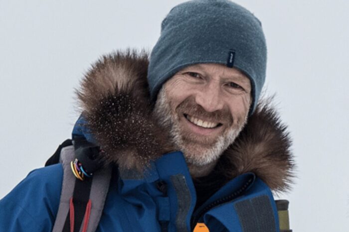
0The Polar Explorer's First-Aid Kit: Borge Ousland's Checklist
ELEvgenii LepikhinBorge Ousland's polar traveler's first-aid kit for the Ellesmere Island expedition: antibiotics, analgesics, wound care products, and other medications.
Borge Ousland, the greatest polar explorer of the last 30 years, shared the composition of his first-aid kit. This list was used by him to cross Ellesmere Island from north to south in 2025. It seemed to me that some ideas would be useful in expedition alpinism as well.
 The first-aid kit is compiled based on the actual problems that Ousland or his partners faced. Always consult a doctor before using any medication. Note that some medications are banned from free circulation in most countries!
- Apocillin 660 mg, 50 tablets. Broad-spectrum antibiotic, particularly useful for joint infections.
- Flagyl 400 mg, 10 tablets. Antibiotic used to treat bacterial and parasitic infections. Also useful for preventing appendix and dental problems.
- Azitromax 500 mg, 6 tablets. Antibiotic used to treat various bacterial infections, especially respiratory ones, such as pneumonia and bronchitis.
- Doxylin 100 mg, 18 tablets. Broad-spectrum antibiotic, effective for skin infections.
- Paralgin Forte, 50 tablets. Analgesic for moderate to severe pain relief.
- Paracetamol, 50 tablets. Over-the-counter analgesic for mild to moderate pain relief.
- Ibux 400 mg, 40 tablets. Relieves headache, rheumatic, and muscular pain.
- Acetylsalicylic acid, 1 tablet per day. Aspirin.
10
0Pavlenko's Video Guide: The Classic (5B) on Pobeda
ELEvgenii LepikhinVideo guide to climbing **Pobeda Peak** via the classic 5B route with **Dikiy Pass** by experienced mountaineer Dima Pavlenko.
Video guide to the classic route (5B, via Diky Pass) on Pobeda by Dima Pavlenko.
Loading video...
9
0Showing 31–40 of 7076 results