6
0Eastern Siberian Bergland
Mountain range1,516,427.47 km²
Polish Alpinist Completes First Winter Solo Ascent of Yakutia's Pobeda
 ELEvgenii Lepikhin
Maciej Bereta, a Polish traveler, made the first winter solo ascent of Mt Pobeda in Yakutia, one of the coldest mountains on the planet, and was awarded the 11th Shackleton Award for crossing the Anabar Plateau.
Unless you live in Siberia or Canada's Arctic, you likely don't know cold like Maciej Berbeka, a Polish computer science specialist and traveler who has been undertaking solo climbs for over a decade in what he calls some of the coldest and most inaccessible mountain ranges and plateaus on Earth.
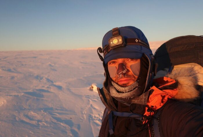 Berbeka's latest expedition took place in February. It was the first winter solo ascent of https://summitx.info/ru/objects/peaks/12625907/about, and it perfectly illustrates his longstanding interest in extreme cold and autonomous travel.
The Coldest Mountain on the Planet?
 Pobeda, the highest peak in Yakutia, was previously climbed in winter in 2018 by climbers Simone Moro and Tamara Lunger. Moro called it "the coldest climb in history, on the coldest mountain on the planet," as temperatures as low as -70˚C have been recorded in the region.
Berbeka started his winter solo from the same point as Moro and Lunger. He ascended in a single day, tracing a line through deep, loose snow all the way. "Of all my solo winter ascents in North Siberia, this was definitely the most challenging," he said.
"Others were just as cold, maybe even colder, but none were even close in terms of technical difficulties and snow conditions," he added.
Pobeda, the highest peak in Yakutia, was previously climbed in winter in 2018 by climbers Simone Moro and Tamara Lunger. Moro called it "the coldest climb in history, on the coldest mountain on the planet," as temperatures as low as -70˚C have been recorded in the region.
Berbeka started his winter solo from the same point as Moro and Lunger. He ascended in a single day, tracing a line through deep, loose snow all the way. "Of all my solo winter ascents in North Siberia, this was definitely the most challenging," he said.
"Others were just as cold, maybe even colder, but none were even close in terms of technical difficulties and snow conditions," he added.
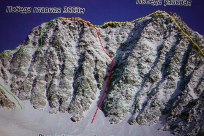
 Berbeka reached the start of the route on skis, then switched to crampons and ascended via the south wall, repeating the route through the central couloir taken in 2018.
Summiting in the Dark
Route Description: ЮЗ гребню
 SSummitMate
Report on the ascent of the UAL team to **Peak Skalolazov Osetii** via the South-West ridge, category 1B complexity.
Report
On ascending to the summit of Pik Skalolazov Osetii via the Southwest Ridge, category 1B, by the UAL Mountain Club team, for the period September 1, 2023.
| 1. General Information | ||
|---|---|---|
| 1.1 | Full name, sports rank of the leader | Chikin Artem Borisovich, 1st sports rank |
| 1.2 | Full name, sports rank of participants | Bobrinskiy K.I., 1st sports rank, Butakov A. S., 3rd sports rank, Marinich E. E., 3rd sports rank, Golovushkin E. Yu, 1st sports rank |
| 1.3 | Full name of coach | Yakovenko Alexander Nikolaevich |
| 1.4 | Organization | MC «UAL» |
| 2. Characteristics of the Ascent Object | ||
| 2.1 | Region | Magadan Oblast, Khrebet Bolshikh Porogov |
0
0Route Description: СЗ гребню
SSummitMate
Report on the first ascent to Vozmozhnost peak via the north-western ridge, category 1B route, completed by the Magadan city tourist club team on September 12, 2020.
Report
On the first ascent to the summit Vozmozhnost via the Northwest Ridge route, category 1B, by the team of the Magadan City Tourist Club, from September 12, 2020, to September 12, 2020. 2020
I. Climbing Report
| № | 1. General Information | |
|---|---|---|
| 1.1 | Full Name, Sports Rank of the Leader | Ivan Vasilievich Kergin — 2nd sports rank |
| 1.2 | Full Name, Sports Rank of the Participants | Yakov Alekseevich Leukhin — Badge Atabala Rovshanovich Kasumov — No rank |
| 1.3 | Full Name of the Coach | Ivan Vasilievich Kergin |
| 1.4 | Organization | Magadan City Tourist Club |
0
0Route Description: В кулуару Ю стены
SSummitMate
Report on the first ascent to the summit of Trog via the 2B category route through the eastern couloir of the southern wall.
Report
On the first ascent to the summit of Trog (Glavny) via the Eastern couloir, South wall, category 2B complexity route by the team of the Magadan City Tourist Club from June 12, 2020, to June 14, 2020.
I. Climbing Report
| № | 1. General Information | |
|---|---|---|
| 1.1 | Full name, sports rank of the team leader | Ivan Vasilievich Kergin, 2nd sports rank |
| 1.2 | Full name, sports rank of the participants | Aleksandr Aleksandrovich Antipov — 3rd sports rank; Ivan Vasilievich Kergin — 2nd sports rank; Atabala Rovshanovich Kasumov — no rank; Suzanna Aleksandrovna Cherednichenko — no rank; Egor Pavlovich Pervushkin — no rank |
| 1.3 | Full name of the coach | Ivan Vasilievich Kergin |
| 1.4 | Organization | Magadan City Tourist Club |
0
0Route Description: центральному зеркалу СВ стены
SSummitMate
Report on the first ascent to the summit of Afrodita via the central mirror of the Northeast wall, a 2A category route, by a team from the Federation of Alpinism and Rock Climbing of the Republic of Sakha.
Report on the First Ascent of Mt. Afrodita (2060 m) via the Central Mirror of the Northeast Wall, Category 2A difficulty, by the team from the Federation of Alpinism and Rock Climbing of the Republic of Sakha (Yakutia)
July 11, 2021
I. Ascent Passport
| № | 1. General Information | |
|---|---|---|
| 1.1 | Full Name, Sports Rank of the Leader | Bogomolov Valery Alexandrovich, 1st sports rank |
| 1.2 | Full Name, Sports Rank of the Participants | Makarov Vasily Alexandrovich, 2nd sports rank Sayfulin Oleg Viktorovich, 2nd sports rank |
| 1.3 | Full Name of the Coach | Ivanov Vasily Ivanovich № 72 |
| 1.4 | Organization | Federation of Alpinism and Rock Climbing of the Republic of Sakha (Yakutia) |
| 2. Characteristics of the Ascent Object |
1
0Route Description: центр. кф. В гребня
SSummitMate
Description of the category 2B route to the 2060 m peak (Aphrodite) in the Tas-Kystabyt Range, Republic of Sakha (Yakutia), with technical details and characteristics.
Climbing Passport
- Climbing area: Tas Kystabyt Ridge (Sarychev), southwestern part of Chersky Range — Sakha Republic (Yakutia), section 9.7
- Peak, route: p. 2060 m (local name Aphrodite), Central Counterfort of the Eastern Ridge Peak coordinates: 64°28′719″ N, 143°14′297″ E according to GPS.
- Estimated category of difficulty: 2B, first ascent
- Route type: Rocky
- Route characteristics:
- Height difference according to GPS — 490 m Route length — 950 m Section lengths:
1
0Route Description: СЗ ребру
SSummitMate
First ascent of the peak Aphrodita (2060 m) by the North-West Edge in the Tas-Kystabyt Ridge, cat. 2B.
Ascent Passport
- Ascent area: Tas Kystabyt Ridge (Sarychev Ridge), section 9.7
- Peak: peak 2060 m (local name: Aphrodite). Northwest edge (N 64° 28.719 E 143° 14.297)
- Proposed: Category 2B difficulty, first ascent.
- Route type: rock climbing.
- Route description: Elevation gain according to GPS 490 m Distance 1400 m. Average slope 28° Section lengths:
- 1 — 950 m
1
0Route Description: В гребню с перевала
SSummitMate
Description of the first ascent of the 2060 m peak (Aphrodite) in the Tas-Kystabyt ridge via a category 2A route, featuring a detailed description and photographs.
Ascent Passport
- Ascent area: Tas Kystabyt Ridge (Sarychev), southwestern part of Chersky Ridge, Sakha Republic (Yakutia) section 9.7
- Peak, route: p. 2060 m (local name Aphrodite), E ridge from the pass. Peak coordinates 64°28′719″ N 143°14′297″ E by GPS.
- Estimated category of difficulty 2A, first ascent.
- Route type: Rocky.
- Route characteristics: height difference by GPS — 470 m Route length — 1600 m Section lengths:
- 1 — 1100 m
1
0Route Description: ЮВ ребру
SSummitMate
Report on the first ascent to the summit of Semyon Mostakhov (2162 m) via the South-Eastern edge, category 1B difficulty level in July 2016.
Alpinism and Rock Climbing Federation of the Republic of Sakha-Yakutia
Report
On the ascent to the summit of Semyon Mostakhov (proposed by the Yakut branch of the Russian Geographical Society) 2162 m, via the South-Eastern ridge, made during the training camp in Yakutsk in July 2016.
July 2016
Table of Contents
- Ascent Passport
- Photograph of the summit
- Map of the area
- Brief description of the area
- Technical photo of the route
1
0Route Description: В склону
SSummitMate
Ascent to Ploskaya Dalnyaya - Ushkovsky volcano (3943 m) via the eastern slope, category of difficulty 2A, ice and snow route.
Ascent Record
- Climbing area: Kamchatka. Klyuchevskaya group of volcanoes.
- Name of the peak: Ploskaya Dalnaya — Ushkovsky 3943 m. Eastern slope.
- Suggested category of difficulty — 2A.
- Type of route: ice and snow.
- Height difference: 1200 m.
- Route length: 2.5 km.
- Average steepness: 35°.
- Moving time: 7 hours.
- Number of days: 1 day.
0
0Showing 1–10 of 69 results