
Report
On the first ascent to the summit of Trog (Glavny) via the Eastern couloir, South wall, category 2B complexity route by the team of the Magadan City Tourist Club from June 12, 2020, to June 14, 2020.
I. Climbing Report
| № | 1. General Information | |
|---|---|---|
| 1.1 | Full name, sports rank of the team leader | Ivan Vasilievich Kergin, 2nd sports rank |
| 1.2 | Full name, sports rank of the participants | Aleksandr Aleksandrovich Antipov — 3rd sports rank; Ivan Vasilievich Kergin — 2nd sports rank; Atabala Rovshanovich Kasumov — no rank; Suzanna Aleksandrovna Cherednichenko — no rank; Egor Pavlovich Pervushkin — no rank |
| 1.3 | Full name of the coach | Ivan Vasilievich Kergin |
| 1.4 | Organization | Magadan City Tourist Club |
| 2. Characteristics of the Climbing Object | ||
| 2.1 | Region | Magadan Oblast, Verkhoyansk Highlands, Dёl-Urekchen mountain range |
| 2.2 | Valley | Agan Valley |
| 2.3 | Classification table section number for 2013 | — |
| 2.4 | Name and height of the summit | Mt. Trog (Glavny). Height 1566 m |
| 2.5 | Geographical coordinates of the summit (latitude/longitude), GPS coordinates | 60°21′21.9″ N, 150°48′20.3″ E |
| 3. Route Characteristics | ||
| 3.1 | Route name | Eastern couloir — South wall |
| 3.2 | Proposed category of complexity | 2B |
| 3.3 | Route освоенности degree | First ascent |
| 3.4 | Route terrain character | Rocky |
| 3.5 | Height difference of the route (altimeter or GPS data) | 336 m |
| 3.6 | Route length (in meters) | 195 m |
| 3.7 | Technical elements of the route (total length of sections of varying complexity with terrain character indication (ice-snow, rocky)) | 1A category complexity. Rocks — 30 m. 2A category complexity. Rocks — 50 m. 3A category complexity. Rocks — 50 m. 4A category complexity. Rocks — 65 m. Movement on closed glacier — 0 m. Dülfer descent (on descent) — 115 m |
| 3.8 | Descent from the summit | Descent to the saddle via the south wall. Then eastward along a long grassy ledge to the eastern couloir |
| 3.9 | Additional route characteristics | Rockfall hazard |
| 4. Team Actions Characteristics | ||
| 4.1 | Time of movement (team's walking hours, in hours and days) | 10 hours |
| 4.2 | Overnight stays | No |
| 4.3 | Departure on the route | 9:10 AM, June 13, 2020 |
| 4.4 | Summit attainment | 12:29 PM, June 13, 2020 |
| 4.5 | Return to the base camp | 7:50 PM, June 13, 2020 |
| 5. Responsible for the report | ||
| 5.1 | Full name, e-mail | Ivan Vasilievich Kergin, ivan.kergin@mail.ru |
II. Climbing Description
1. Characteristics of the Climbing Object

Fig. 1. General view of the summit from the East. Photo taken with a drone, near the overnight stay. June 13, 2020.
Photo by: Maxim Berezhnoy
1.2. Route Profile Photo

Fig. 2. Route profile photo from the East. Photo taken with a drone near the "Finger". June 13, 2020.
Photo by: Maxim Berezhnoy
1.3. Panoramic Photo of the Area

Fig. 3. Photo from the summit 1243 m. August 22, 2020. Photo by: Ivan Kergin
1.4. Geographical Location of the Area
The climbing object — Mt. Trog Glavny (Trog Peak), height 1566 m, is located in the Khasynsky District of Magadan Oblast, in the Dёl-Urekchen (Del-Urekchen, Dzhel-Urekchen) mountain range in the Verkhoyansk Highlands. Its location is in the upper reaches of the Nelkandya River in the Agan River valley. Mt. Trog is a long ridge with a series of towers and summits: Trog Southeast and Trog Southwest, as well as several жандармов.
"The Dёl-Urekchen mountains are a small granite massif located in the Arman basin and bounded to the south by the Kava-Taiginsk lowland, and to the north by the Magadaven and Ola rivers. It is characterized by significant snow accumulation and alpine features. On average, the mountains rise to 1100 m. A number of peaks with elevations around 1500 m are crowned with cirque ridges. The highest point is Mt. Agan (1718 m). The Dёl-Urekchen mountains have a highly dissected relief. There are many cirques and narrow, serrated ridges. The northwestern part of the massif is dissected by Arman tributaries. To the south, high peaks give rise to Nelkandi tributaries. The mountains are treeless, and only along the river valleys do forests penetrate deeply into them." — R. Sedov, "Mountains of the Okhotsk Coast".
The ascent was made from the Agan River valley, a right tributary of the Trog stream. The base camp was located on the left bank of the Trog stream.
To get to the area from Magadan city, take cars to Palatka settlement (86 km — 1 hour), then head to the federal highway R-504 "Kolyma", turn onto the municipal Tenka highway "Palatka — Kulu — Neksikan" at the Customs Control Zone (ZTK). Drive 29 km along the Tenka highway to the Agan River and the bridge (29 km — 30–35 minutes).
After crossing the bridge:
- Turn left and take the old tractor road.
- Leave the cars on the tractor road.
- Head on foot upstream along the Agan River along the forest road, which will lead to the right tributary of Agan — Trog stream and the base camp (14 km — 5–6 hours), located at the foot of the mountain.
Note: the path from the Agan River to the foot of Mt. Trog (Glavny) can be traveled by a high-clearance vehicle to save strength and time.
From the base camp, follow the tractor road to the first talus couloir, then ascend it to the rocky "Finger", from which traverse a small yellow pass to the main Eastern couloir with a rocky island — the beginning of the route. From the base camp, it takes 1–1.5 hours.
The nearest settlement with regular bus service is Palatka settlement, 86 km from Magadan city, and 43 km from the base camp.
Fig. 4. Map of the area

Fig. 5. Schematic map of the area
2. Route Characteristics
2.1. Technical Photo of the Route

Fig. 6. Technical photo of the route from the Agan River valley. August 22, 2020. Photo by: Evgeny Serov
2.2. Section Numbers
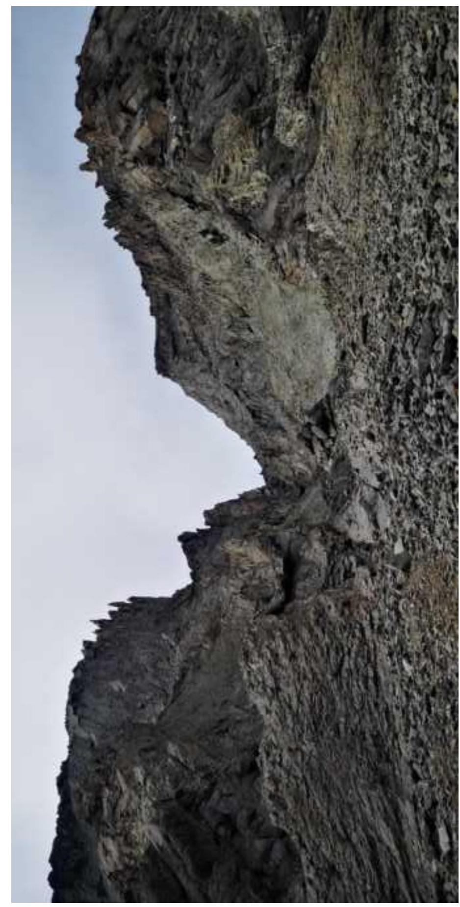 Fig. 7. Section R0–R1. Photo by: Ivan Kergin
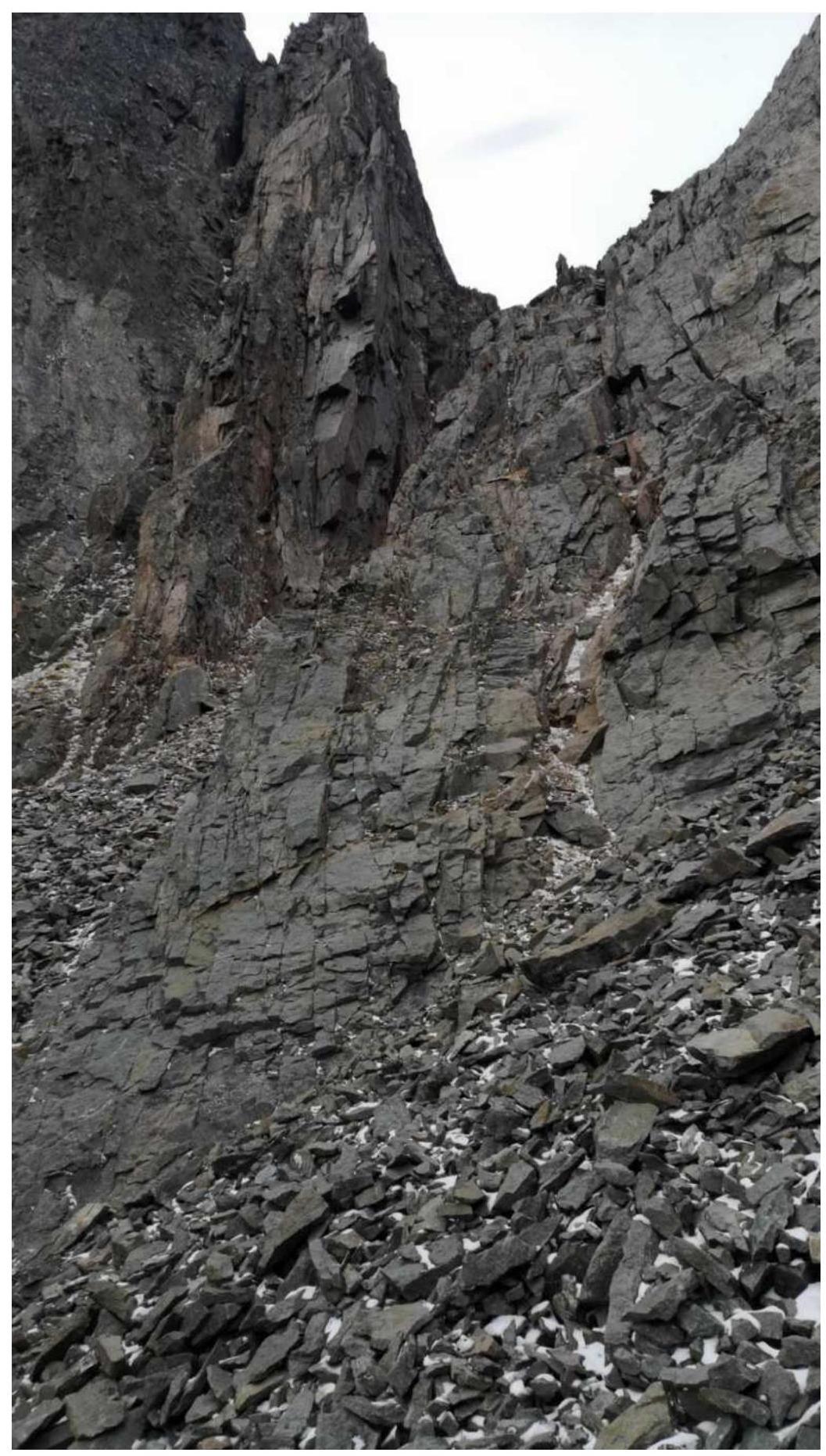
Fig. 8. Section R1–R2 (First part). Photo by: Ivan Kergin

Fig. 9. Section R1–R2 (Second part). Photo by: Ivan Kergin

Fig. 10. Section R2–R3. Photo by: Atabala Kasumov

Fig. 11. Section R2–R3 (Photo from Trog SW). Photo by: Maxim Berezhnoy

Fig. 12. Section R2–R3–R4. Photo by: Maxim Berezhnoy

Fig. 13. Section R3–R4. Photo by: Atabala Kasumov
2.3. Technical Characteristics of the Route
| Section № | Terrain character | Category of complexity | Length, m | Steepness | Type and number of pitons |
|---|---|---|---|---|---|
| R0–R1 | Talus | 2 | 50 m | 40° | 0 |
| R1–R2 | Rocky wall, talus ledge | 3 | 50 m | 45° | Friend — 1; Stopper — 1; Anchor piton — 1 |
| R2–R3 | Rocky walls, ledges, inclined slabs | 4 | 65 m | 55°–65° | Friend — 5; Stopper — 2 |
| R3–R4 | Ridge, talus | 1 | 30 m | 0° | Station loop — 2 |
2.3. Technical Characteristics of the Route in UIAA Symbols

3. Team Actions Characteristics
3.1. Brief Description of the Route Passage
| Section № | Description | Photo № |
|---|---|---|
| R0–R1 | Ascend the eastern couloir, passing the rocky island on the right, approach the chimney with a plug, pass it on the left. Then move rightward via a traverse to the wall. Simultaneous movement. | Fig. 7. |
| R1–R2 | Ascend the rocky wall to an inclined ledge (on the left side along the direction of movement, the chimney will be on your left, so you're moving correctly), from which exit to a saddle where it's convenient to organize a belay station on a "balda". The leader sets up vertical rappel. Movement via rappel. | Fig. 8–9. |
| R2–R3 | Ascend rocky walls and ledges (cracks for large and medium-sized chocks) to inclined slabs. To the left of the slabs is a rocky "Tooth", keep right of it and climb to a steep wall (90°) — the key section of the route. Then proceed to the pre-summit ridge, where it's convenient to organize a belay station on a "balda". The leader sets up vertical rappel. Movement via rappel. | Fig. 10–11. |
| R3–R4 | From the station, traverse along the talus ridge to the summit. The leader sets up horizontal rappel. Movement via rappel. | Fig. 13. |
3.2. Team Photo on the Summit with the Control Tour

3.3. Route Safety Assessment
The route is rockfall-prone, which adds to its complexity. However, there are sufficient safe locations to gather and continue work.
There is no communication; it's better to use portable radios to stay in touch with each other. Truck drivers passing near the Agan valley can also be helpful, as they can be contacted in case of an emergency to notify the nearest settlement — Palatka.
Recommendations for future climbers: The terrain is varied. Mainly schist, but also granite. It's better to use friends and stoppers, and refrain from using pitons as they can be carried as extra weight, although it's a good idea to have one in reserve. On stations, it's better to use large station loops as it saves time on organization compared to tying repp cord.
Descent from the summit follows the ascent route. However, after the last Dülfer descent on section R1–R2, it's better to head to the saddle between Trog Southeast and Trog Southwest, and from there descend via medium and large talus to the Luna pass, from which it's easy to descend to the tractor road and head back to the base camp — this descent is much safer than via the eastern couloir.
This route was completed on June 13, 2020. No signs of human presence were found on the summit: no tour, no tin can with a note, or other distinguishing features. Moreover, known literary sources do not confirm that Mt. Trog (Glavny) has been climbed before. Therefore, we decided that we were the first to stand on its summit.
Based on the objective complexity of the technical part of the route to Mt. Trog (Glavny) via the eastern couloir on the south wall, and comparing it with other routes previously climbed by I. Kergin and A. Antipov, we propose classifying it as category 2B complexity.
Comments
Sign in to leave a comment