5
0South Summit
Peak8,849 m
Nepal: Climbing Everest Only After 7,000 Meters
 ELEvgenii Lepikhin
Nepal introduces new rules for climbing Everest: climbers must first ascend a 7,000-meter peak in Nepal to prevent inexperienced climbers from attempting the ascent.
New Everest Climbing Regulations: Climbing a 7,000-meter Peak in Nepal First is Now Mandatory
 Nepal's National Assembly has passed a new tourism bill that requires climbers to first ascend a 7,000-meter peak in Nepal before tackling Everest. This new regulation aims to deter inexperienced or unprepared climbers from attempting the mountain and to develop the expedition business in the country.
Every year, new regulations are proposed for trekking and mountaineering in Nepal, and now they are on the verge of becoming national law. The requirement for climbers to have prior experience ascending a 7,000-meter peak in Nepal before attempting Everest is the most notable innovation.
Nepal's National Assembly has passed a new tourism bill that requires climbers to first ascend a 7,000-meter peak in Nepal before tackling Everest. This new regulation aims to deter inexperienced or unprepared climbers from attempting the mountain and to develop the expedition business in the country.
Every year, new regulations are proposed for trekking and mountaineering in Nepal, and now they are on the verge of becoming national law. The requirement for climbers to have prior experience ascending a 7,000-meter peak in Nepal before attempting Everest is the most notable innovation.
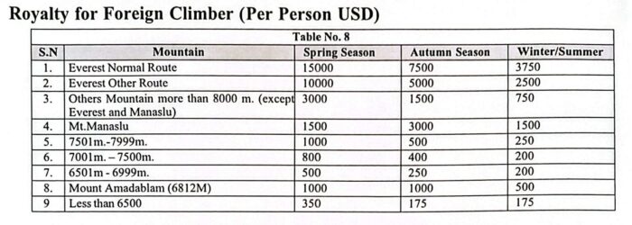
 According to officials, this provision is designed to curb the growing number of inexperienced climbers attempting the world's highest peak, which often leads to congestion, accidents, and strain on rescue services. Nepal has 86 peaks between 7,000 and 7,999 meters, and the climbing fee for foreigners ranges from 500to800 during the spring season.
Some of the rules outlined in the bill have also featured in other recent ordinances, such as the requirement to provide a recent medical certificate to obtain a climbing permit. The bill also lays the groundwork for a general environmental fund that will collect money from climbers.
According to officials, this provision is designed to curb the growing number of inexperienced climbers attempting the world's highest peak, which often leads to congestion, accidents, and strain on rescue services. Nepal has 86 peaks between 7,000 and 7,999 meters, and the climbing fee for foreigners ranges from 500to800 during the spring season.
Some of the rules outlined in the bill have also featured in other recent ordinances, such as the requirement to provide a recent medical certificate to obtain a climbing permit. The bill also lays the groundwork for a general environmental fund that will collect money from climbers.
Everest: Statistics and Facts of the 2026 Season
ELEvgenii Lepikhin### Everest Statistics as of December 2025 - **Total Ascents:** 13,737 - **Total Deaths:** 339 - Notable trends include a steady **increase in climbers** and **fatalities** - The role of **supplemental oxygen** and **Sherpa support** is significant.
Overall Statistics (as of December 2025)
As of December 2025, there have been 13,737 summits of Everest, corresponding to a 43% success rate. Of those who reached the summit, 7,563 different people have stood on the top. 339 people have died on all routes. Nepal remains the more popular and more deadly side. 9,887 summits and 229 deaths were recorded on the Nepalese side, corresponding to a death rate of approximately 2.3%. On the Tibetan side, there were 3,850 summits and 110 deaths, a death rate of 2.8%. The use of supplemental oxygen remains one of the strongest predictors of survival. 180 of the 339 deaths occurred among climbers ascending without supplemental oxygen.
Tibet or Nepal?
The Nepalese side remains the most popular route and has recorded the highest absolute number of fatalities. The Tibetan side has recorded a slightly higher percentage of deaths — 2.8%, but a comparable normalized mortality rate — 1.05.
Deaths Rise with the Number of Climbers
Since 2000, Everest has experienced an unprecedented influx of climbers. 15,781 people climbed above Base Camp in Nepal from 2000 to 2025, nearly triple the total number for the previous 80 years. Throughout Everest's history (1921–2025), 339 people have died on the mountain. The average number of deaths increased to approximately seven deaths per year from 2010 to 2025.
Standard Routes — 98% vs. Non-Standard Routes — 2%
5
0Route Description: центру С стены
 SSummitMate
First ascent of the North Face of Everest via the centre, category 6B, mixed route, 2648 m of height difference, 5350 m long.
Ascent Passport
- High-altitude category.
- Himalayas, Tibet, China, Rongbuk Glacier.
- Everest 8848 m via the center of the North Face.
- Proposed - 6B category of difficulty, first ascent.
- Route elevation gain: 2648 m. Route length: 5350 m. Section length: Cat. diff. – 740 m, Cat. 1 diff. – 150 m. Average steepness of the main route section – 46°.
- Hooks left on the route: approximately 140; including pitons: 0. Hooks used on the route: more than 300. Total IT used: 40.
2
0Route Description: кулуару СВ стены
SSummitMate
Report on the first ascent of route category 6B on the NNE wall of Everest (8848 m) by a team led by Pyotr Kuznetsov in May 1996.
PASSPORT
I. High-altitude category 2. Himalayas 3. Mount Everest, 8848 m, NNE wall. 4. Proposed - 6B category of difficulty, first ascent. 5. Height difference: 2328 m, wall section 1780 m;
- length 3738 m, wall section 2238 m; length of sections with 5–6 category of difficulty 1790 m; average steepness of the main part of the route 52°.
- Pitons hammered in: | Rock | Nuts | Ice and snow |
2
0Route Description: СВ гребню через С седло
SSummitMate
Report on the ascent of the Krasnodar mountaineering club "Ekstrem" team to Everest via the North-East ridge through the North Col in 2000.
Ascent Passport
- Ascent class — high-altitude.
- Ascent area: China, Tibet — Himalayas, Rongbuk gorge.
- Peak: Everest (8848 m) via the Northeast ridge through the North Col.
- Complexity category — 5B.
- Elevation gain (from ABC camp) 2450 m, distance (from ABC) 6000 m. Length of sections with 5th cat. complexity — 25 m 6th cat. complexity — none
6. Number of pitons driven:
rock placements ice screw pitons snow anchors
1
0Route Description: СВ гребню через С седло
SSummitMate
Description of the ascent of Everest via the Northeast Ridge, category of difficulty 4.5-6, climbed by a team in May 1998.
- Class — high-altitude technical.
- Central Himalayas.
- Everest via the Northeast Ridge with ascent through the North Col (8848 m). 4,5–6B cat. dif.
- Elevation gain: 2210 m, route length — 5150 m. Length of sections with 5 cat. dif. — 920 m, 6 cat. dif. — 60 m.
- Pitons driven: | rock | nuts | ice | snow | | :--------: | :-------: | :------: | :--------: | | 26+39* | 0 | 8 | 40+9* |
1
0Route Description: СВ гребню через С седло
SSummitMate
### Ascent of Everest via the Northeast Ridge in 1997 Category: 6B difficulty, 3698 m elevation gain, led by Suviga V.I.
Passport
- High-altitude category
- Himalayas, Central Tibet, East Rongbuk Glacier
- Mt. Everest via the Northeast Ridge
- Category 6B difficulty
- Elevation gain – 3698 m
- Pitons used | Rock | Ice | Snow | | :--- | :--- | :--- | | 35 | 40 | 40 |
1
0Route Description: СВ гребню через С седло
SSummitMate
Report on the ascent of the team from the Republic of North Ossetia-Alania to Jomolungma (Everest, 8848 m) via the Northeast Ridge in 1995.
Ascent Passport
- Ascent class: High-altitude.
- Ascent area: Himalayas, Tibet.
- Peak, route: Chomolungma (Everest 8848 m) via the North-East Ridge.
- Complexity category: 5B.
- Height difference:
- including 2348 m of actual wall section
- total route length — 2168 m
- wall section length — 5900 m
- including 4300 m of 5th complexity category
0
0Route Description: СВ гребню через С седло
SSummitMate
Description of the ascent to Everest via the Northeast Ridge in 2002 by a team led by G. Kirievsky, including a detailed tactical plan and its implementation.
Ascent Passport
- Climbing class — high-altitude
- Himalayas
- Everest Peak 8848 m via NE ridge
- Complexity category 5B
- Elevation difference — from ABC camp to the summit 2448 m
- Number of travel days — preparation — 33 days
- ascent — 6 days
- Intermediate camps: | | |
0
0Route Description: с Ю седла
SSummitMate
Description of the ascent route to Everest via the South Col with 5B category of difficulty, completed in May 1999 by a group led by B. Kashakashvili.
10.1.26
Ascent Log
- Ascent category: High-altitude
- Ascent area: Himalayas
- Peak, route: Everest, via South Col
- Estimated category of difficulty: 5B
- Height difference: 3548 m
- including wall section — 50 m
- total route length — 12300 m
- wall section length — 60 m
0
0