
-
Class — high-altitude technical.
-
Central Himalayas.
-
Everest via the Northeast Ridge with ascent through the North Col (8848 m).
4,5–6B cat. dif.
- Elevation gain: 2210 m, route length — 5150 m.
Length of sections with 5 cat. dif. — 920 m, 6 cat. dif. — 60 m.
- Pitons driven:
| rock | nuts | ice | snow |
|---|---|---|---|
| 26+39* | 0 | 8 | 40+9* |
| 0 | 0 | 0 | 0 |
- — reuse of previously driven pitons.
-
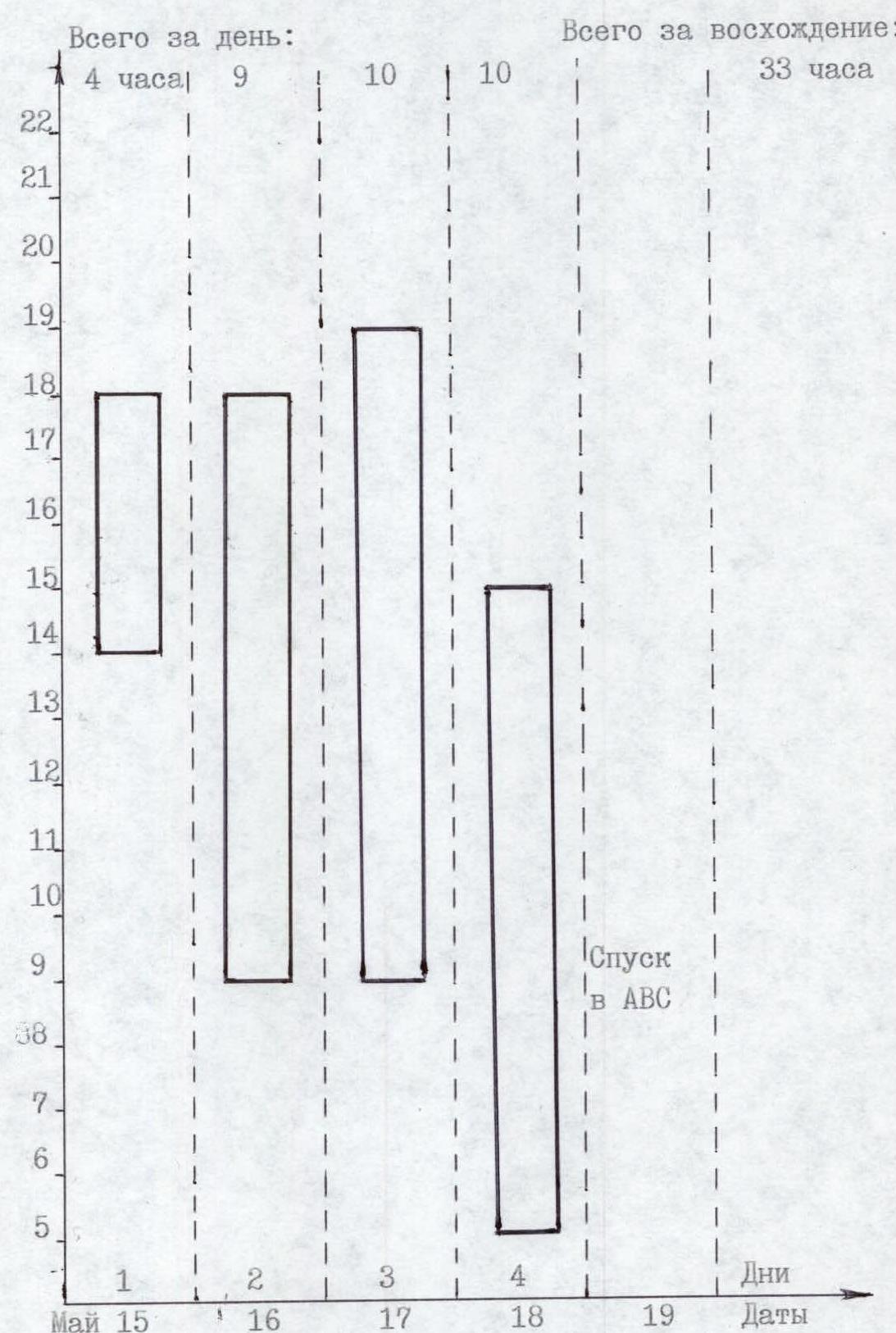
Team's moving hours: 33 h, 4 days.
-
Overnights: 1st – 7000 m, lying in a tent; 2nd – 7800 m, lying in a tent; 3rd – 8300 m — lying in a tent.
-
Leader: Valery Nikolayevich Pershin HMS
Team members:
- Yevgeny Mikhailovich Vinogradsky HMS
- Sergey Vladimirovich Timofeev MS
- Alexey Vasilyevich Bolotov MS
- Coaches: Valery Nikolayevich Pershin HMS, coach HC
Nikolay Nikolayevich Zakharov IMS, coach HC
- Departure to the route: May 15, 1998.
Summit: May 18, 1998, return: May 19, 1998. 12. Organization: combined team of Sverdlovsk, Perm regional sports committees, Krasnoyarsk regional sports committee, St. Petersburg sports committee led by Boris Alexandrovich Sedusov.
Sverdlovsk Regional Sports Committee address: 620151, Yekaterinburg, Malyshev St., 60, ph. 51-33-02
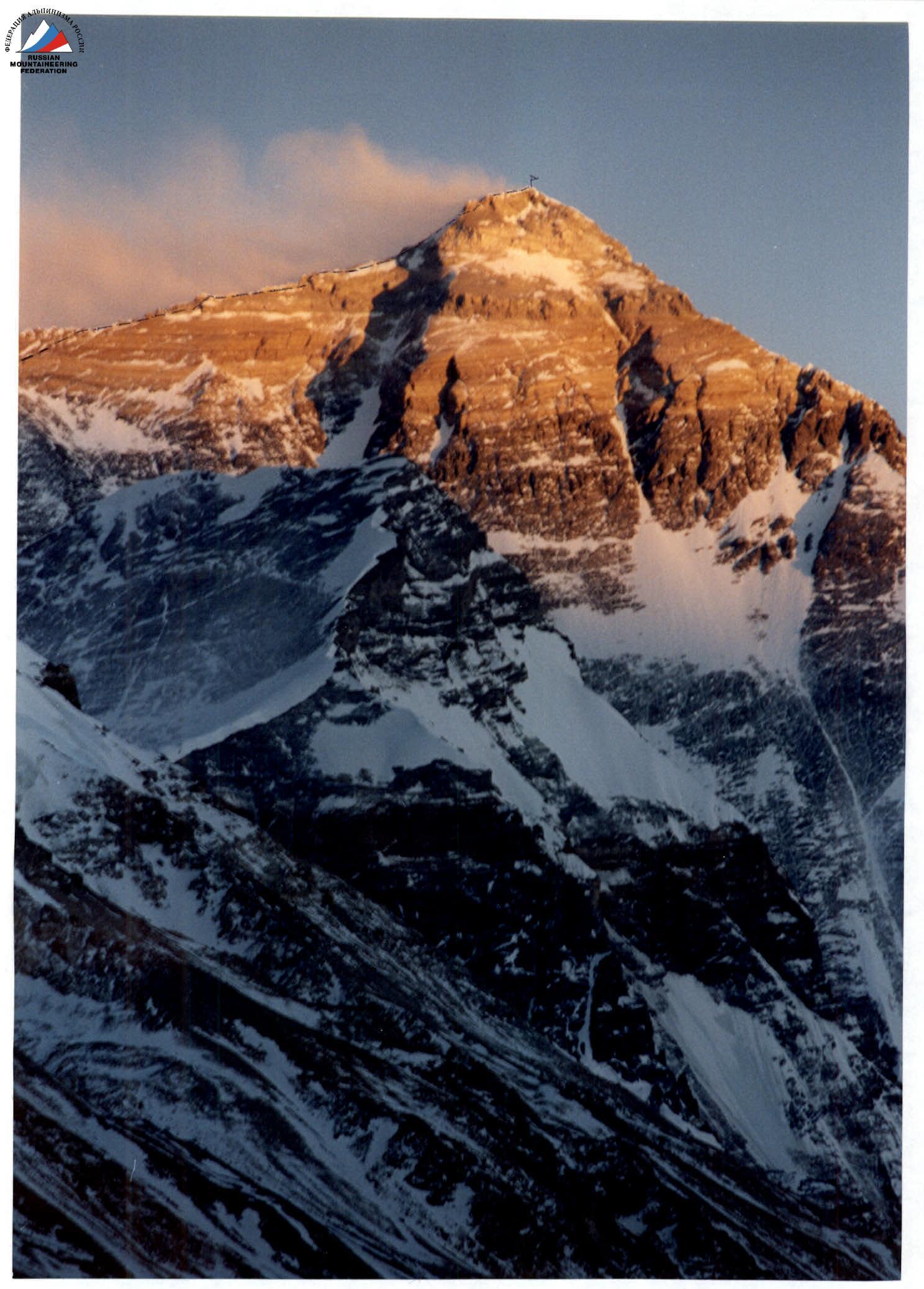
Photo 1. General photo of the summit. Taken on April 20, 1998.
— team's route
Ascent Schedule
Team's Tactical Actions
Key factors in developing the tactical plan:
- need for good acclimatization;
- combined nature of the terrain;
- high absolute altitude of the summit;
- unstable weather in the ascent area.
A feature of ascents in the Himalayas is that expedition members who have obtained a "permit" for the summit are not allowed to climb neighboring peaks. Good acclimatization is achieved by alternating ascents along the route with rest in the base camp. The ascent route is processed along the way.
Implementation of the tactical plan:
- route processing by the entire expedition team and organization of Camp #1 on the North Col, Camp #2 at an altitude of 7800 m;
- a long period of bad weather in early May did not allow organizing Camp #3 at an altitude of 8300 m;
- the forward group of four expedition members set up Camp #3 along the ascent route but could not complete the ascent to the summit above the 1st step due to the poor condition of the route after bad weather and lack of time;
- the ascent was made by the second group of four a day later using oxygen from an altitude of 8300 m.
The team had a sufficient arsenal of equipment to ensure insurance on all forms of mountain relief, a first-aid kit with the necessary set of medications, reliable "Kanchenjunga" tents, gas burners, and a large number of gas cylinders.
The route was completed in accordance with the temporary schedule of the tactical plan with a large margin of safety, without breakdowns or accidents, due to the many years of experience of the ascent participants in the mountains, their high technical, physical, and psychological preparation and teamwork.
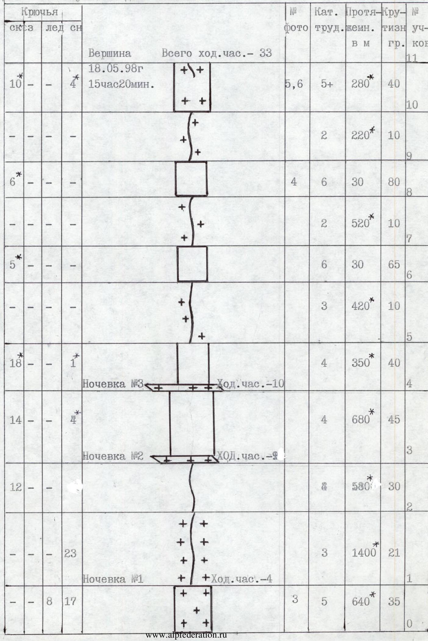
Route Diagram in UIAA Symbols M 1 : 2000
- — sections are not to scale
Summit: May 18, 1998, 15:20. Total moving hours: 33.
| Rock Pitons | Ice Pitons | Snow Pitons | Photo # | Cat. dif. | Length, m | Steepness, deg. | Section # |
|---|---|---|---|---|---|---|---|
| 5,6 | 5+ | 280* | 40 | 11 | |||
| 2 | 220* | 10 | 10 | ||||
| 9 | |||||||
| 10 | 4 | 6 | 30 | 80 | |||
| 2 | 520* | 10 | 7 | ||||
| 6 | 6 | 30 | 65 | 6 | |||
| 3 | 420* | 10 | 5 | ||||
| Night #3. Moving hours: 10. | |||||||
| 18 | 1 | 4 | 350* | 40 | 4 | ||
| Night #2. Moving hours: 9. | |||||||
| 14 | 680* | 45 | 3 | ||||
| 12 | 580* | 30 | |||||
| Night #1. Moving hours: 4. | |||||||
| 8 | 17 | 3 | 5 | 640* | 35 | 1 | |
| 23 | 3 | 1400* | 21 | 0 |
Route Description by Sections
Section R0–R1: Ascent to the North Col via the icefall. Ice and snow pitons are necessary for organizing belays. Be wary of falling seracs and avalanche formation after snowfall.
Section R1–R2: Wide snow ridge with several sections of steep climbs.
Section R2–R3: Wide rock ridge, partially snow-covered.
Section R3–R4: Slope, alternating rocks and snow.
Section R4–R5: Exit to the Northeast Ridge. Snow-covered rock slabs alternate with fairly complex and steep rock walls. Belays are necessary.
Section R5–R6: Simple ridge. Snow cornices overhang to the left. Move to the right of the top of the ridge along the slope towards the 1st step.
Section R6–R7: 1st step. Steep rock wall with limited holds. Belays are necessary.
Section R7–R8: Simple snow-covered ridge.
Section R8–R9: 2nd step. Vertical rock wall with a ledge in the middle. An aluminum ladder is fixed in the upper part.
Section R9–R10: Simple ridge.
Section R10–R11: Pre-summit tower. After the rock wall, a steep snow climb is traversed from left to right. Then the slope is traversed along snow-covered ledges. Ascend to the start of the snow-ice summit ridge via a rock crevice. Summit.
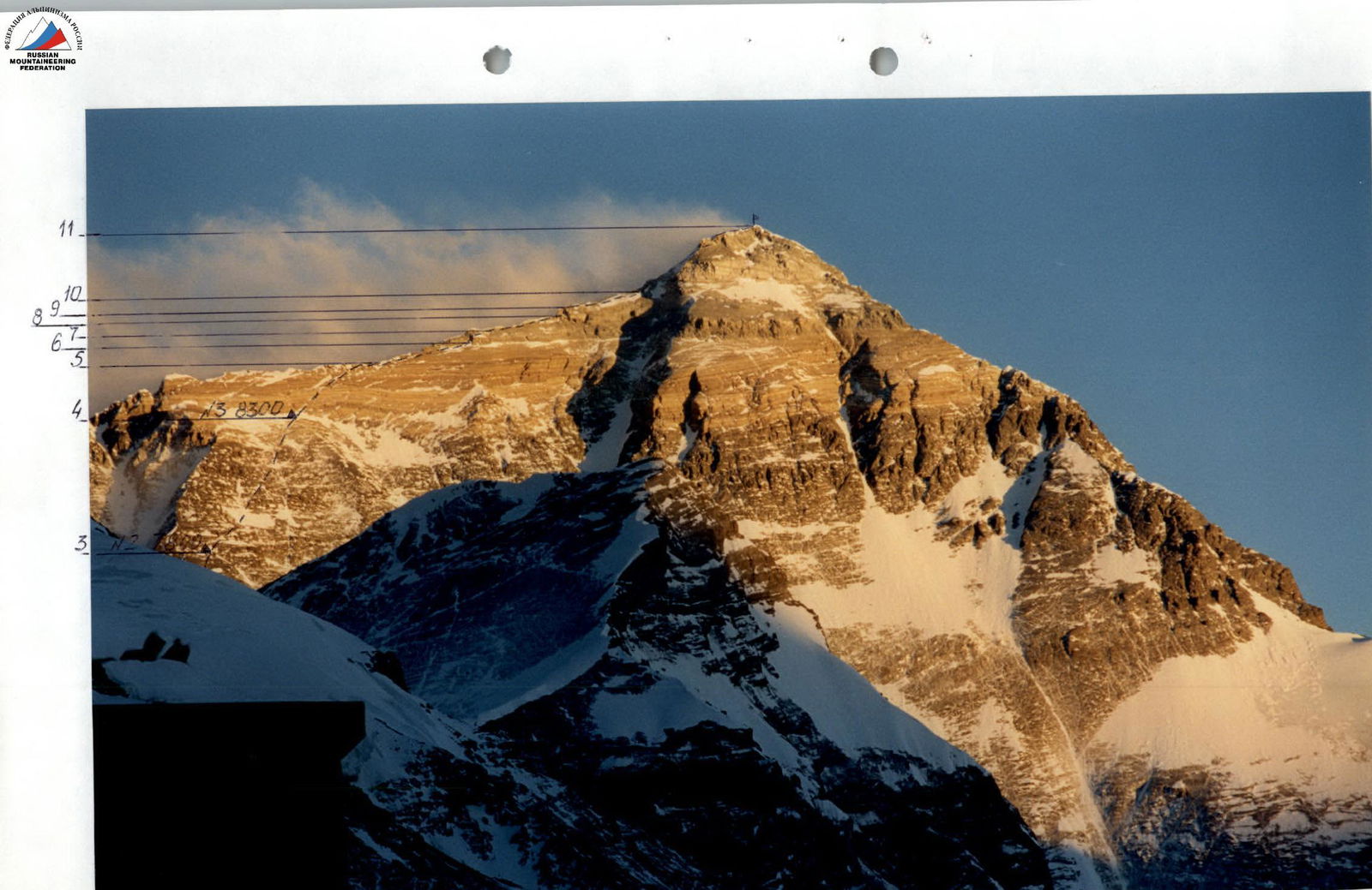
Photo 2. Technical photo of the route.
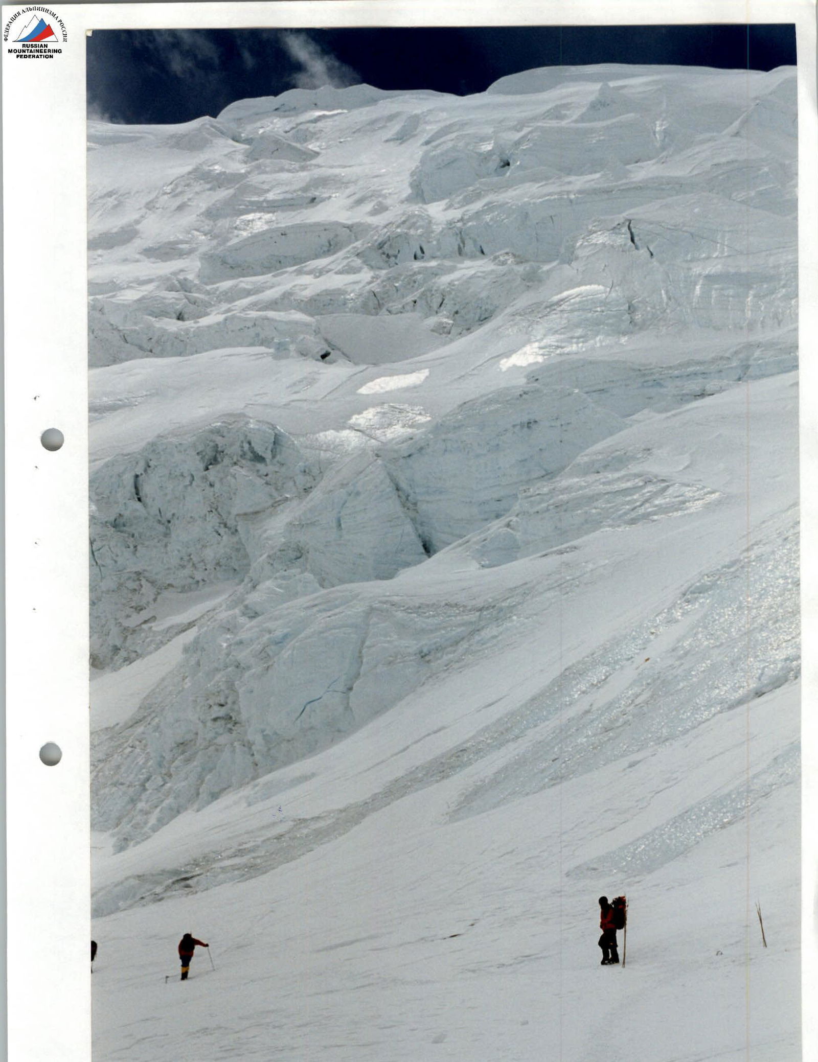
Photo 3. Section R0–R1, ascent to the North Col.
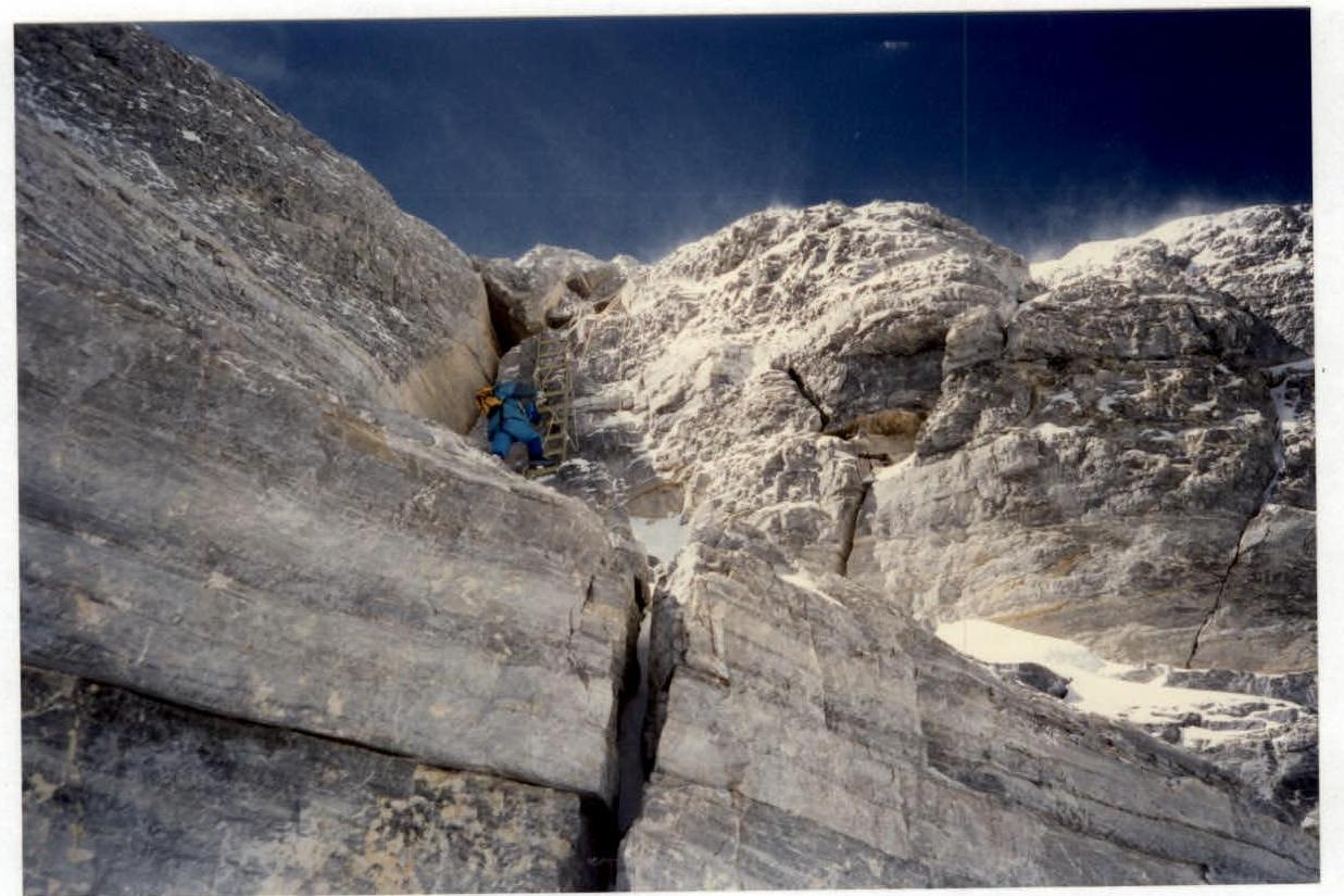
Photo 4. Overcoming the 2nd step.
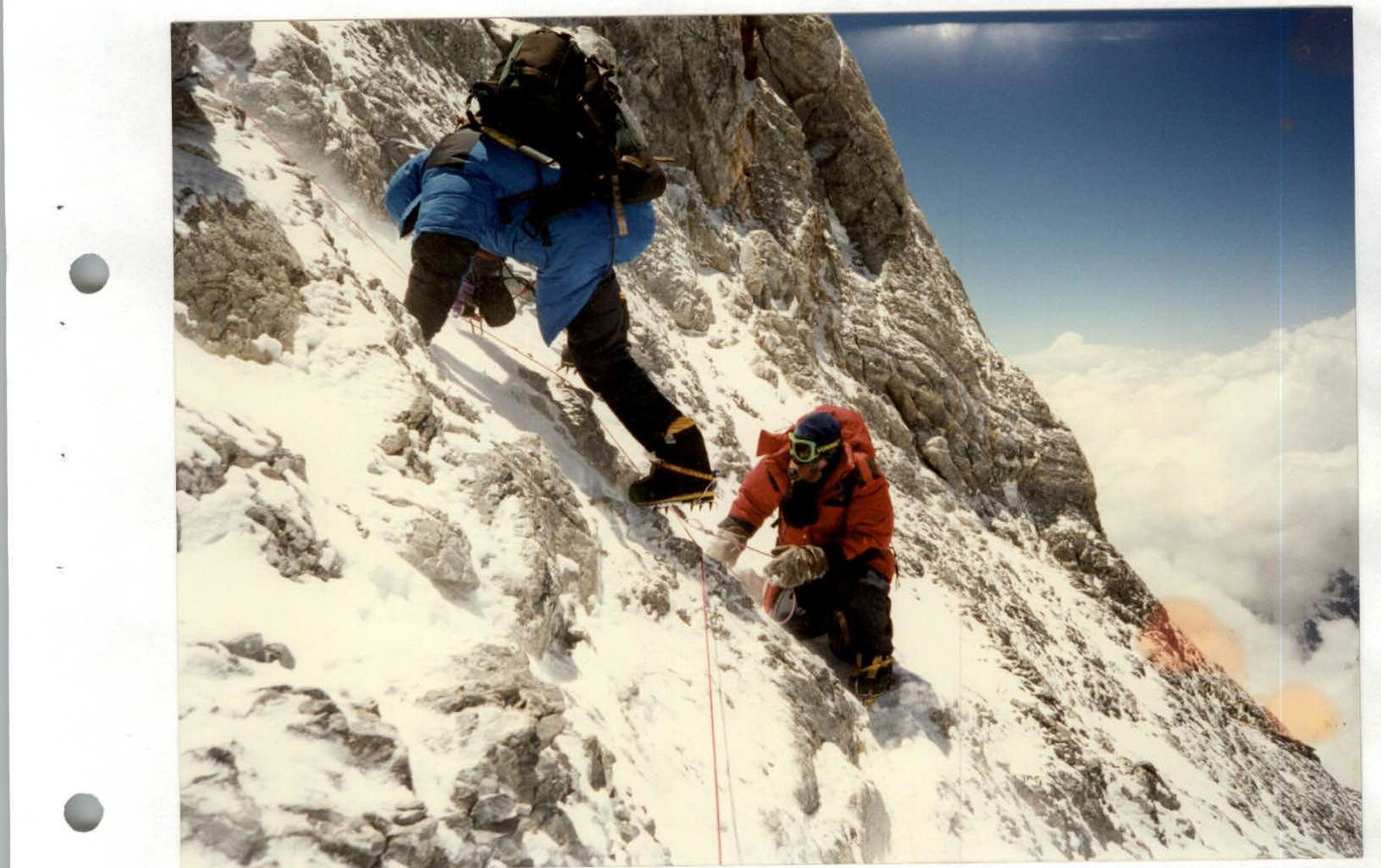
Photo 5. Moving along the rocks of the pre-summit tower.
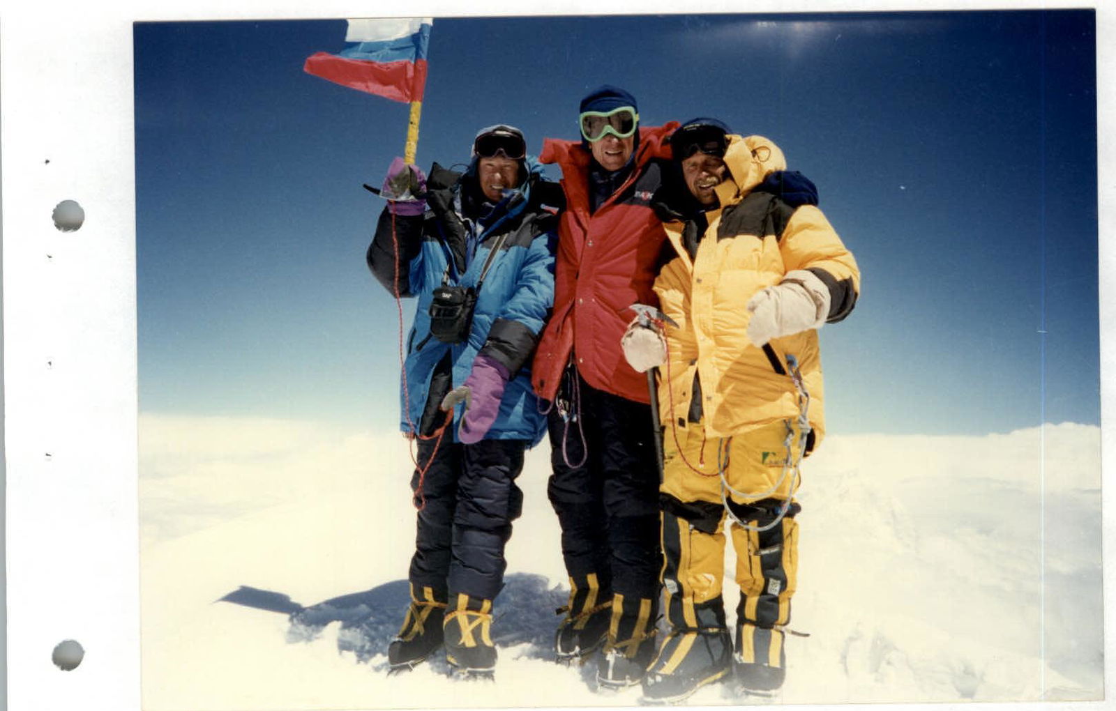
Photo 6. At the summit.

Comments
Sign in to leave a comment