
PASSPORT
I. High-altitude category
- Himalayas
- Mount Everest, 8848 m, NNE wall.
- Proposed - 6B category of difficulty, first ascent.
- Height difference: 2328 m, wall section 1780 m;
- length 3738 m, wall section 2238 m; length of sections with 5–6 category of difficulty 1790 m; average steepness of the main part of the route 52°.
- Pitons hammered in:
| Rock | Nuts | Ice and snow |
|---|---|---|
| 44 | 48 | 113 |
- Climbing time 42 hours, 5 days; with preliminary processing 110 hours, 15 days.
- Overnights: 1st, 2nd, 3rd in tents set up on ice-cut platforms; 4th, 5th in tents on scree platforms.
- Leader: Kuznetsov Pyotr Valentinovich, MS
Participants:
- Kokhanov Valery Petrovich, MS
- Semikolenov Grigory Leonidovich, CMS
- Coach: Zakharov Nikolay Nikolayevich
- Route entry: May 15, 1996. Summit: May 20, 1996. Return: May 22, 1996.
- Organization: Krasnoyarsk Regional Committee for Physical Culture and Sports.
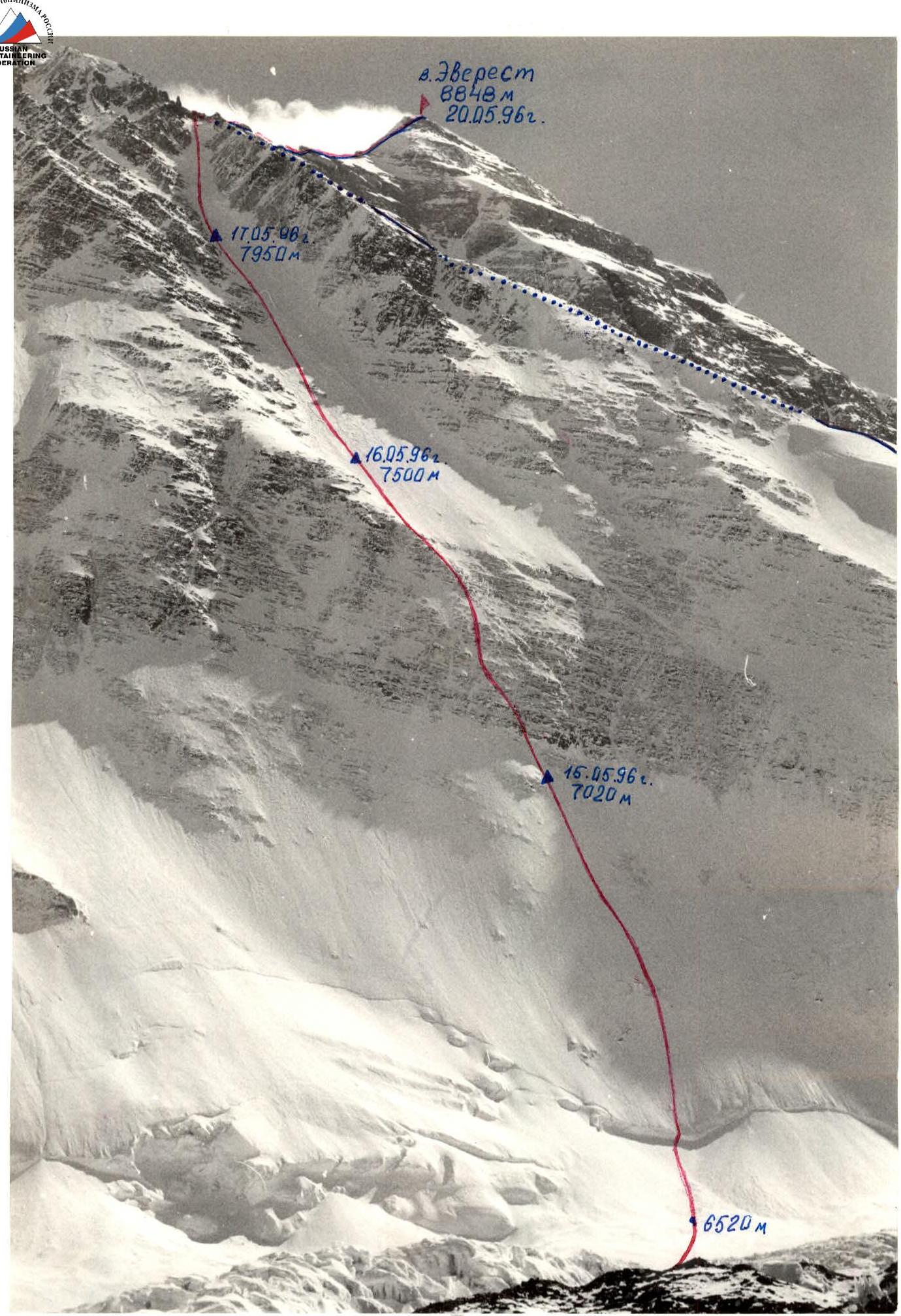
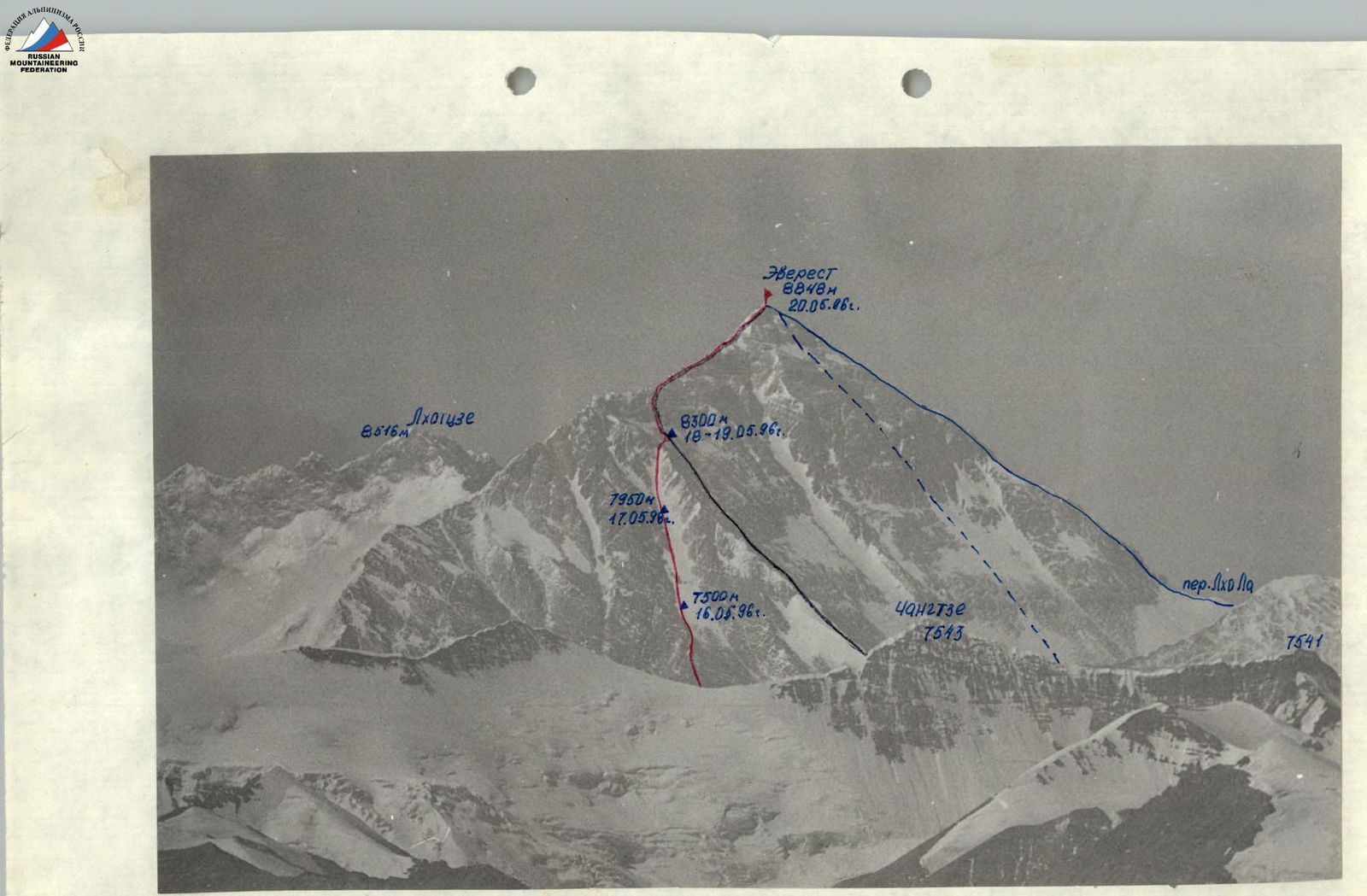
General photo of the summit. Taken on April 30, 1996 at 13:00, distance 4 km, shooting height 6450 m. Pentacon lens, F=85 mm. Team route, China, 1960.
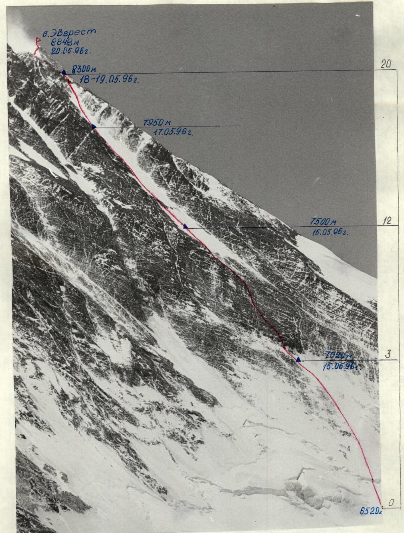
Photo of the route from the left. Taken on April 25, 1996 at 9:30, distance 5 km, shooting height 6300 m. Pentacon lens, F=85 mm.

Tactical Actions of the Team
The route of the first ascent via the NNE wall of Everest was completed from May 15 to May 20, 1996. The route line followed the tactical plan without deviations. The team members who started the route:
| Participant | Rank | Role |
|---|---|---|
| P. Kuznetsov | MS | leader |
| N. Zakharov | IMS | |
| V. Kokhanov | MS | |
| E. Bakaleinikov | MS | |
| A. Bekasov | CMS | |
| G. Semikolenov | CMS |
The base camp of the expedition was located at a traditional site, at an altitude of 5200 m, and was established on April 5. The advanced base camp (ABC) was set up on April 11 at an altitude of 6350 m on the lateral moraine of the West Rongbuk Glacier.
Preliminary route processing was carried out:
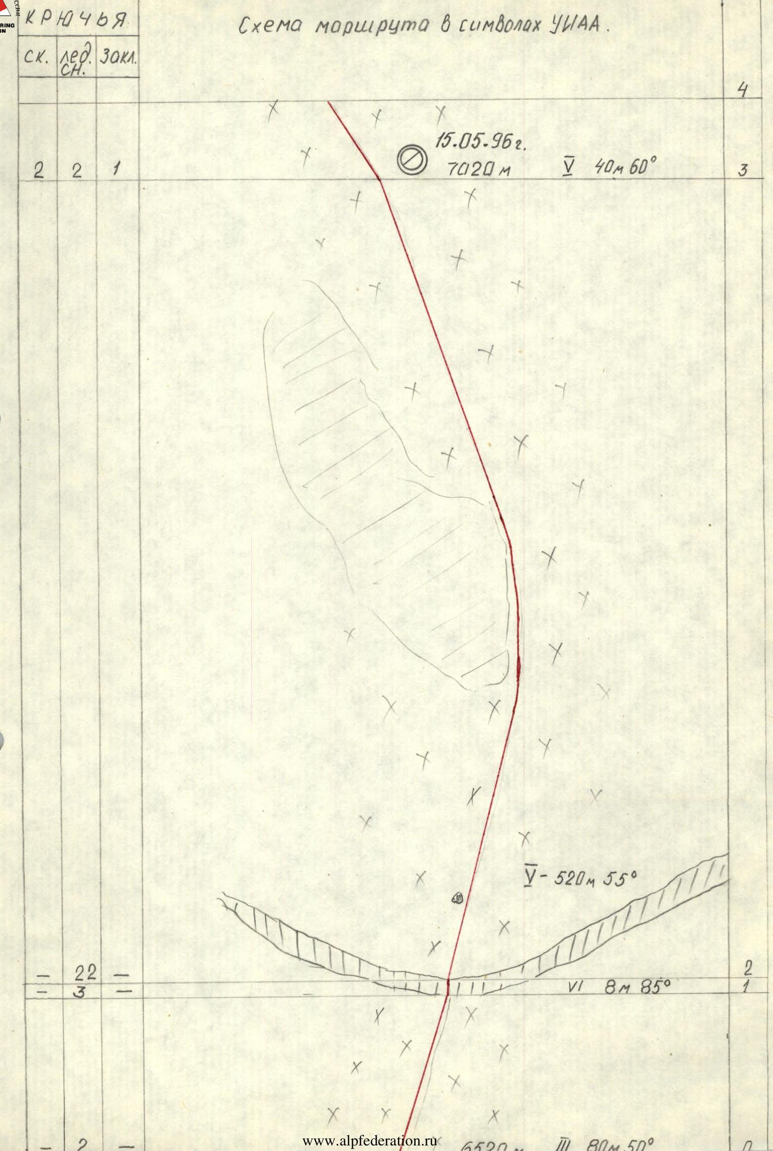
- From April 12 to 14 from an altitude of 6520 m to 7020 m - bergschrund and ice wall up to the rock belt (Section 0–3);
- From April 22 to 24 - Camp I was set up (7020 m) and the rock belt was processed (Section 3–11) up to an altitude of 7440 m;
- From May 2 to 5, Sections 11–16 were processed up to an altitude of 7860 m, and Camp 2 was set up at an altitude of 7500 m.
Between departures, all participants descended to the base camp for rest and recovery.
The team started the route on May 15 and stopped for the night in Camp I.
On May 16, the team passed Sections 3–12 and spent the night in Camp 2. On May 17, the processed Sections 12–16 were passed, then the team ascended to the planned altitude of 7950 m and set up the third camp, where they spent the night. On May 18, the team passed the upper part of the couloir and reached the North ridge. The duo Bekasov-Kuznetsov, who were leading, reached the planned bivouac site at an altitude of 8300 m and set up a tent. The remaining four, due to strong winds and approaching darkness, had to set up a tent at the beginning of the traverse from the ridge to the camp site. Constant radio communication was maintained between the duo and the quartet.
In Camp 8300, Kuznetsov and Bekasov found a dying member of an Austro-Hungarian expedition in a nearby tent. Information was relayed via radio to ABC, and assistance was provided to the Austrian throughout the night, including oxygen, but he passed away by morning. The incident was reported down, and a response was received that Austrians were ascending to their location.
On May 19, due to strong winds and a sleepless night, Kuznetsov and Bekasov were unable to continue the ascent. The quartet's tent was moved to Kuznetsov's tent. It was decided to wait for the wind to subside.
On May 20, strong winds and frost persisted in the morning with clear weather. They managed to depart at 7:00 when the wind began to die down. Upon reaching the NE ridge, the weather began to deteriorate, with clouds gathering, visibility worsening, and heavy snowfall starting.
At 15:00, P. Kuznetsov reached the summit, followed by V. Kokhanov, then G. Semikolenov. They were followed in order by N. Zakharov, E. Bakaleinikov, and A. Bekasov.
During the descent, everyone met at an altitude of around 8800 m. The weather worsened: snowfall intensified, and visibility was lost. There was a risk that someone might get lost while descending from the NE ridge. Therefore, it was decided to stop the ascent and descend together, within direct visibility, which proved to be the correct decision as the team descended in full to Camp 4, where they spent the night.
On May 21, they descended to the North Col, and on May 22, to ABC.
Oxygen was used by all participants from an altitude of 8650 m only during heavy work. Oxygen was not used while staying in Camp 4.
The route is very challenging: on rocks with a tile-like structure, it's difficult to find reliable cracks for belaying; hard ice shatters, and ice screws are difficult to screw in.
The route is safe because:
- snow practically doesn't accumulate in large quantities in the couloir;
- it immediately flows down and is blown away by strong winds.
A rescue team of 7 highly qualified individuals was stationed in ABC during the team's ascent, with the radio turned on for reception around the clock. The team was equipped with the latest high-altitude gear. Nutrition organization:
- hot meals in the morning and evening;
- individual nutrition and hot tea from thermoses during the day.
The route was completed reliably, technically and tactically competently, with a reserve of physical strength.
Table of food products.
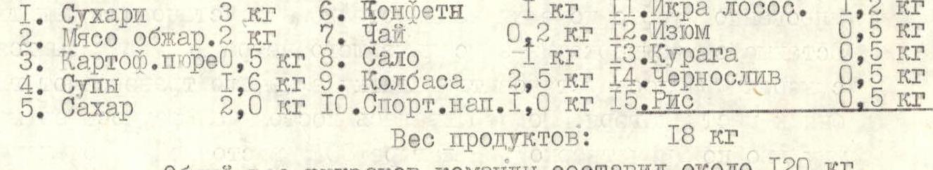
| Product Name | Weight | Product Name | Weight | Product Name | Weight |
|---|---|---|---|---|---|
| 1. Rusks | 3 kg | 6. Sweets | 1 kg | 11. Salmon Roe | 1.2 kg |
| 2. Roasted meat | 2 kg | 7. Tea | 0.2 kg | 12. Raisins | 0.5 kg |
| 3. Mashed potatoes | 0.5 kg | 8. Lard | 1.5 kg | 13. Dried apricots | 1 kg |
| 4. Soups | 1.6 kg | 9. Sausage | 2.5 kg | 14. Prunes | 0.5 kg |
| 5. Sugar | 2.0 kg | 10. Sports drinks | 1.0 kg | 15. Rice | 0.5 kg |
Total weight of products: 18 kg
The total weight of the team's backpacks was around 120 kg.


Description of the Route by Sections
Section 0–1. Steep snow slope. Section 1–2. Bergschrund with a nearly vertical 8 m ice wall. Section 2–3. Steep ice slope, partially covered with snow, ice is very hard, winter conditions. Section 3–4. Approach to the rock belt. Mainly, a thick layer of flow ice on rock outcrops, short ice screws are used. Section 4–5. Along a destroyed wall about 5 m to the entrance of a chimney filled with ice. Short ice screws are used in the chimney. Section 5–6. Long internal corners. Rocks are destroyed, have a tile-like structure. The use of pitons is extremely difficult; short ice screws screwed into ice-filled cracks are helpful. Section 6–7. Series of snow-covered walls. Belaying is mainly through large nuts. Section 7–8. Along the right wall of a steep internal corner. Section 8–9. Rock wall. Passed through the central cleft. Section 9–10. Very complex wall leading to a rock ridge. Under the wall, on an ice ledge, there is reliable belaying on ice screws. Section 10–11. Snow-covered destroyed rocks. Section 11–12. Firn, deep snow in places. Section 12–13. Ice-snow slope. Direction of movement - towards the snow-covered rock belt. At the beginning of the section - overnight stay on a cut-out platform. Section 13–14. Rock belt is passed through a destroyed internal corner. Section 14–15. Ice-snow slope, ice is very hard, ice screws are difficult to screw in. Section 15–16. Very steep ice with snow drifts. Passed along the rocks.
Section 16–17. Firn, deep snow in places, sastrugi. Very strong winds in the couloir. In the middle of the section - overnight stay on a cut-out platform. Section 17–18. Exit from the couloir - very steep hard ice, crampons and ice axes hold poorly - they chip off lenses. Altitude around 8250 m. Section 18–19. Exit to the North Ridge - from left to right along the rock wall. Section 19–20. Traverse from left to right with ascent to the camp site at an altitude of 8300 m. Overnight stay on a scree platform covered with snow. Section 20-summit. Straight up the firn field to the rock belt, which is passed through large internal corners leading to the NE ridge. Further along the right side (by the way) of the ridge through the 1st and 2nd steps to the summit of Everest, 8848 m. Descent from the summit via the ascent route to Camp 8300 m, then along the rocky-snowy North Ridge through the North Col to ABC.
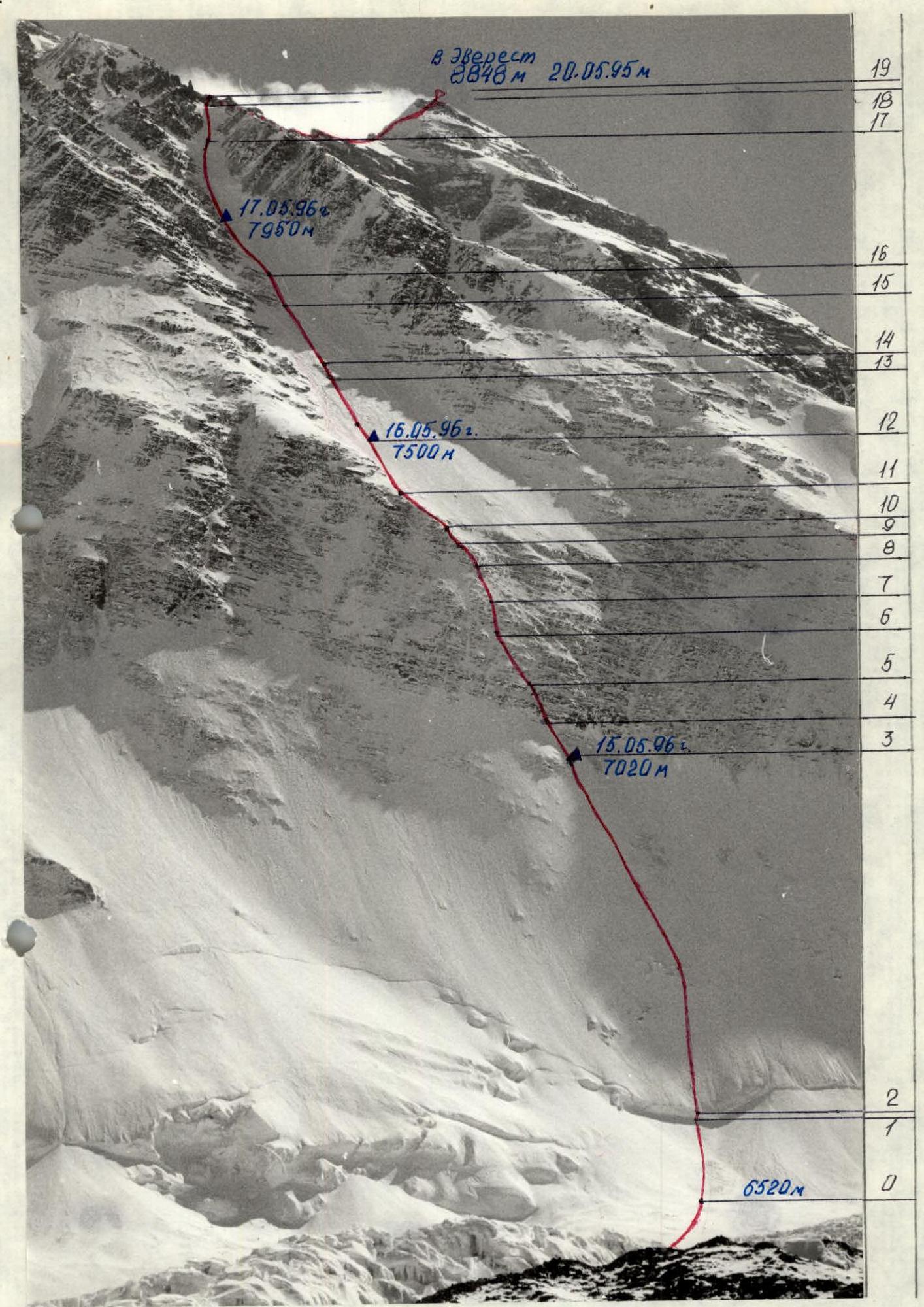
Technical photograph of the route. Taken on April 30, 1996 at 13:00, distance 4 km, shooting height 6450 m. Pentacon lens, F=85 mm.
Comments
Sign in to leave a comment