
39
0Kyrgyz Alatau
Mountain range17,375.73 km²
Pavlenko's Video Guide: "Rechki" Key, 4B on Mt.Baychechekhey
 ELEvgenii Lepikhin
Video guide to the "Rechka" route (4B ice climbing grade) on Pik Baychechekhey with a demonstration of climbing the key wall.
Video guide to the "Rechka" route (Ilyushenko, ice 4B) on Peak Baychechekey by Dima Pavlenko. Captured work on the key wall.
Loading video...
Pavlenko's Video Guide: 3A on Ratsek via the Western Ridge
ELEvgenii LepikhinVideo guide to ascending Peak Ratsek via the Western Ridge (Route 3A) by experienced mountaineer Dima Pavlenko.
Video guide to Route 3A via the west ridge to Peak Ratzek by Dima Pavlenko.
Loading video...
27
0Pavlenko’s Video Guide: Gavrilov’s Route on Korona
ELEvgenii LepikhinVideo guide to the Gavrilov's route (4A) on the peak Korona by experienced alpinist Dima Pavlenko.
Video guide to the Gavrilov's route (4A) on peak Korona by Dima Pavlenko.
Loading video...
21
0Pavlenko's Video Guide: 2B on Ratsek via North Ridge
ELEvgenii LepikhinVideo guide to Route 2Б to Peak Ratzek via the northern ridge by experienced mountaineer Dima Pavlenko.
Video guide for the 2Б route via the north ridge to Razek Peak by Dima Pavlenko.
Loading video...
20
0Pavlenko's Video Guide: Mikhailov Route 5B on Peak Boks
ELEvgenii LepikhinA video guide to the Mikhailov Route (5B, rock climbing) on Peak Boks, presented by experienced mountaineer Dima Pavlenko.
Video guide for Mikhailov's route (5B, rock climbing) on Peak Boks by Dima Pavlenko.
Loading video...
18
0New alpine route: Fedorov
ELEvgenii LepikhinDifficulty:4А / D-
Route type:Ice
Maximum elevation:
4810 mPasses through:Korona Peak
Kyrgyzstan → Uchitel glacier and Korona ridge area
One of the most popular routes to the Corona peak crest wall. It starts from the bergschrund, from which there are about 450 meters of even ice to the ridge. On the penultimate rope of the route, there is a small ice ridge, which is a bit more complicated than the main section of the route. The start of the route is 70-100 meters to the right of the https://summitx.info/en/routes/58844837/about route. In the Russian official classification, both these routes are considered variants of the same route.
21
New alpine route: Markevich' cascade
ELEvgenii LepikhinDifficulty:5Б / TD
Route type:Mixed
Maximum elevation:
4810 mPasses through:Korona Peak
Kyrgyzstan → Uchitel glacier and Korona ridge area
In autumn 2025, two ice streams formed on the northern wall of Pik Korona. The first ascent of the right stream (rated 5A in the Russian classification) was made by Aleksandr Parfyonov's team in early 2026. The first ascent of the left stream was made by Konstantin Markevich with Aleksey Pototskiy in the second half of March 2026. Further, according to Aleksey:
Last year was very hot in July. And as a result of this circumstance, two new routes formed on the northern wall of Pik Korona. The charm of these routes is that this year or next, such conditions may not happen, and these routes may not exist. But while they are there - we have to climb 😁 And we did. One route was climbed by Parfyonov with a partner in February, and the second one - Kostya Markevich and I last week.
Honest 5B and this is the coolest ice in the area. The icicle itself is 170 m of 87-degree lace cascade ice. And before that, there's another 30 meters of A3 ice climbing. The lower part is 450 m of gentle ice at 55-70 degrees.
 Loading video...
Work on the route

10

The article describes logistics, infrastructure, and seasonality for climbers in Kyrgyzstan's national parks, including information on transportation, accommodation, food, and weather conditions.
Logistics
How to Get There
By Private Vehicle
As of May 2025, entry to the national park is closed to vehicles with internal combustion engines. Entry for electric vehicles remains open and costs 800 som. There is a parking lot at the top, costing 50 som for an unlimited time.
By Taxi
You need to get to the entrance to the national park: https://www.openstreetmap.org/#map=19/42.655741/74.495202&layers=P. However, taxi drivers are not very fond of going there, so some minor difficulties may arise. The cost per car is around 600-800 som from the center of Bishkek.
By Public Transport
In May 2025, a free bus was launched. It starts from T. Usubaliev Square (often referred to as the old central square of Bishkek, near monuments and administrative buildings in the center) — a landmark in the city center.
Transport Inside the National Park
If you're not using a private vehicle, you need to pay 200 som per person to enter the national park. The number of days spent in the park is unlimited. Payment can be made in cash, by card, or with national QR transfers. Buses run around the clock from the entrance of the national park to the end of the road inside the park. The interval between buses is approximately every 10 minutes during the day and every 30-40 minutes at night.
56
0The Best Month for Ala-Archa
ELEvgenii Lepikhin
Weather in Ala Archa National Park by month: temperature, stability, precipitation, and safety recommendations for climbers.
People often ask about the weather in Ala-Archa, when the best season is, and when it's safe to ice climb. I've decided to put this information into a micro-article.
January
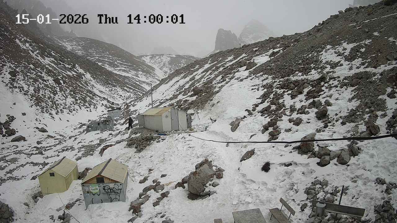 Stable weather, many sunny days, often calm. The temperature at Ratschek hut is -10 to -20°C with rare deviations from this range. However, there's only 2 hours of sunlight per day, not enough to warm up.
February
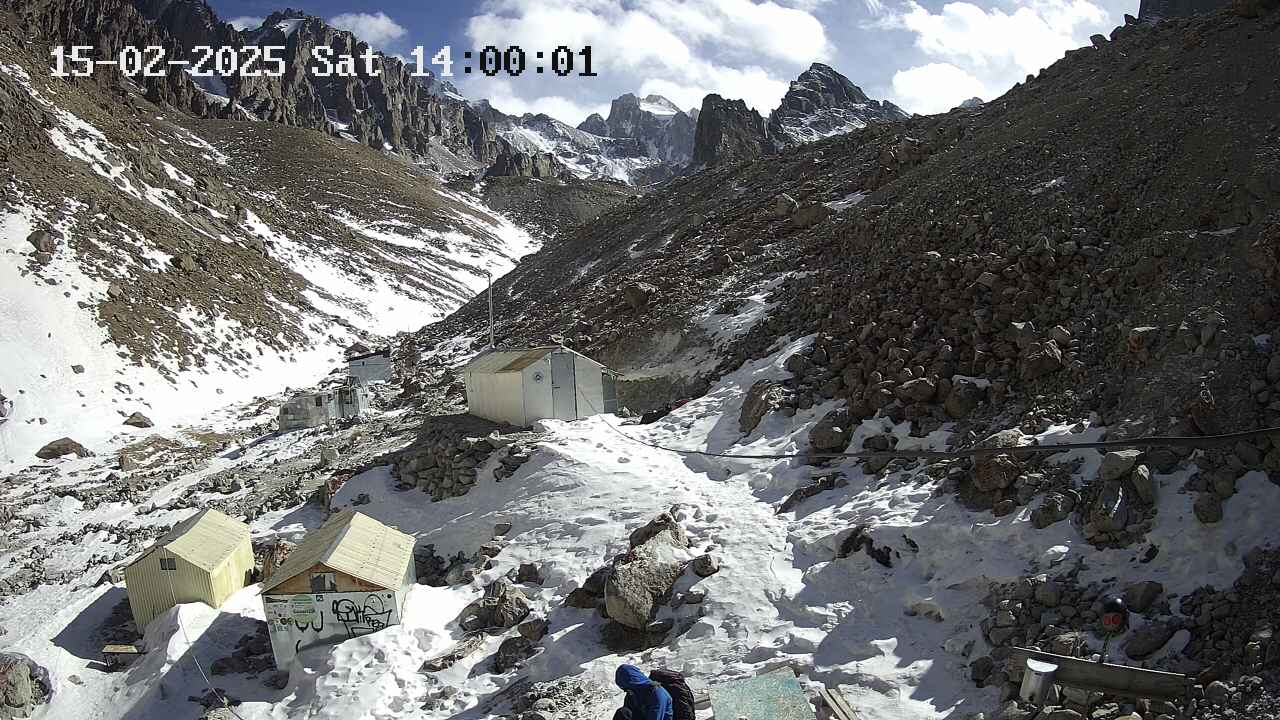 Almost like January, but towards the end of the month, stability is lost – March is approaching.
March
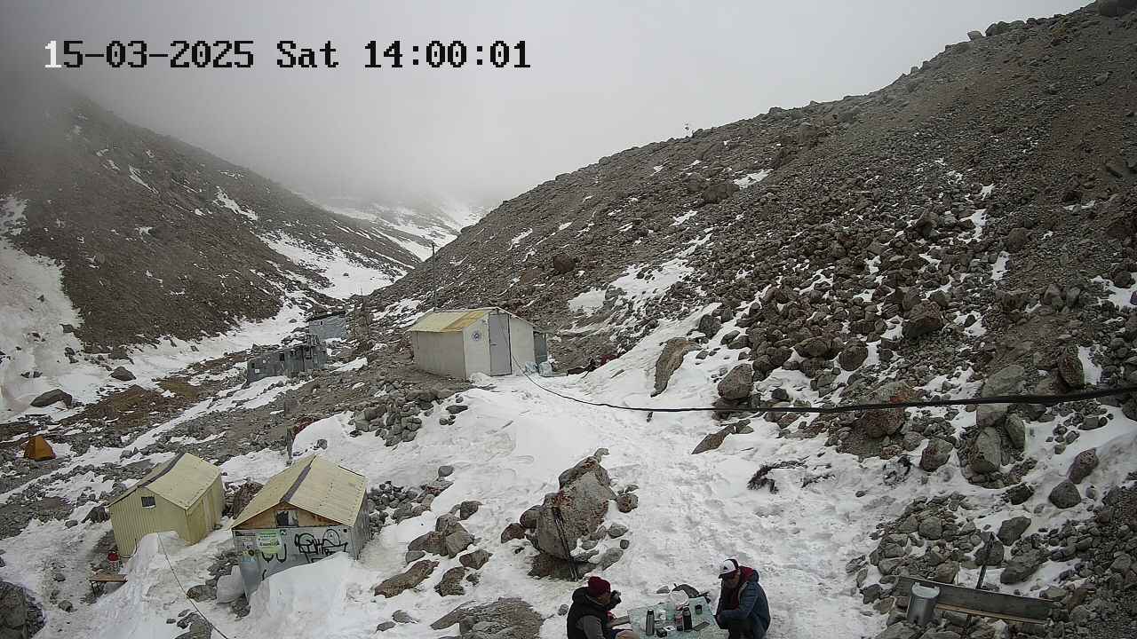 Very unstable weather. Stormy winds can last for 2 consecutive days, and fog can hang for 2 weeks. Heavy snowfalls are rare but possible. On good days, even in early March, it's sometimes possible to walk in a T-shirt when the sun is out. Daytime temperatures range from -10 to +5°C.
April
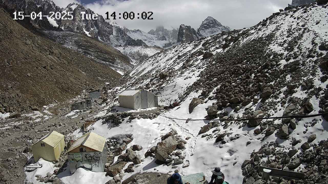 The same March winds, but it gets warmer.
May
6
0Pavlenko's Video Guide: Shvab Route 5A on Baychechekhey
ELEvgenii LepikhinVideo guide to the Schwab route (5A) on Peak Baychechekhey by experienced mountaineer Dima Pavlenko.
Video guide for the Schwab route (5A, rock) on Peak Baychechekhey by Dima Pavlenko.
Loading video...
28
0Showing 1–10 of 324 results