
Report
On the traverse of the Dombay-Ulgen massif (v. Vostochnaya — 3968 m, v. Glavnaya — 4047 m, v. Zapadnaya — 4038 m) (V. Davydov) 5B category of complexity
By the team of the Crimean Republican Club of Alpinists, Climbers, and Ice Climbers "Mountain School 'Category of Difficulty'"
For the period
From August 5, 2023, to August 7, 2023.

Semenov M. A. — MS, leader; Vvedenskaya V. V. — 2nd sports category; Alpinclub — Gornoye bezumiye 2023 year.
I. Climbing report
| 1. General information | ||
|---|---|---|
| 1.1 | Full name, sports category of the leader | Semenov Mikhail Aleksandrovich, MS |
| 1.2 | Full name, sports category of the participants | Vvedenskaya Varvara Vyacheslavovna, 2nd sports category |
| 1.3 | Full name of the coach | Sitnik Mikhail Aleksandrovich, Shipilov Vyacheslav Aleksandrovich |
| 1.4 | Organization | Crimean Republican Club of Alpinists, Climbers, and Ice Climbers "Mountain School 'Category of Difficulty'" |
| 2. Characteristics of the climbing object | ||
| 2.1 | Region | Western Caucasus |
| 2.2 | Valley | Ptysh, Main Caucasian Range |
| 2.3 | Number of the section according to the 2013 classification table | 2.2 |
| 2.4 | Name and height of the peak | Dombay-Ulgen Vostochnaya 3968 m, Dombay-Ulgen Glavnaya 4047 m, Dombay-Ulgen Zapadnaya 4038 m |
| 2.5 | Geographical coordinates of the peak | |
| 3. Characteristics of the route | ||
| 3.1 | Name of the route | Dombay-Ulgen (V — Z), traverse |
| 3.2 | Proposed category of complexity | 5B |
| 3.3 | Degree of route exploration | Rarely visited route |
| 3.4 | Nature of the route terrain | Rocky |
| 3.5 | Height difference of the route (altimeter or GPS data) | 1995 m |
| 3.6 | Length of the route (in meters) | 2935 m |
| 3.7 | Technical elements of the route (total length of sections of varying complexity with indication of the terrain nature (ice-snow, rocky)) | 1st cat. rocky — 20 m. 2nd cat. rocky — 770 m. 3rd cat. rocky — 1465 m. 4th cat. rocky — 180 m. 5th cat. rocky — 460 m. 6th cat. rocky — 40 m. |
| 3.8 | Average steepness of the route, ° | 65° |
| 3.9 | Average steepness of the main part of the route, ° | 90° |
| 3.10 | Descent from the peak | Along the Sosorov route 4B cat. complexity to Ptysh valley |
| 3.11 | Additional characteristics of the route | Challenging crumbly climbing to the summit tower of Vostochnaya and Glavnaya Dombay. |
| 4. Characteristics of the team's actions | ||
| :--: | :-----------------------------------------------------------------------------------------------------------------------------------------------------------: | :------------------------------------------------------------------------------------------------------------------------------------------------------------------: |
| 4.1 | Time of movement (team's walking hours, indicated in hours and days) | 26 hours — 3 days |
| 4.2 | Overnights | 1) On the route in a cave in a tent 2) On the route on the ridge before the "Klyuv" gendarme 3) On the ridge when descending from Zapadnaya Dombay, under the peak. |
| 4.3 | Time of route processing | Alpine style, without processing |
| 4.4 | Departure on the route | 14:05, August 5, 2023 |
| 4.5 | Arrival at the peak | 18:15, August 7, 2023 |
| 4.6 | Return to the base camp | 18:00, August 8, 2023 |
| 5. Characteristics of weather conditions | ||
| 5.1 | Temperature, °C | |
| 5.2 | Wind speed, m/s | |
| 5.3 | Precipitation | |
| 5.4 | Visibility, m | |
| 6. Person responsible for the report | ||
| 6.1 | Full name, e-mail | Semenov M. A., aravigehc@mail.ru |
II. Climbing description
1. Characteristics of the climbing object
1.1. General photo of the peak.
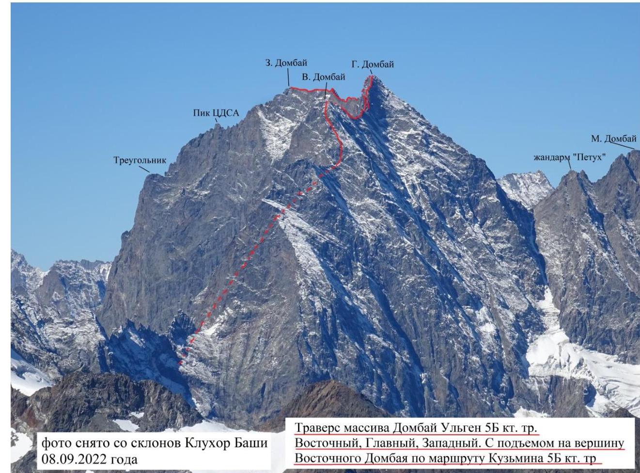 Photo taken from the slopes of Klukhor-Bashi on September 8, 2022.
Traverse of the Dombay-Ulgen massif 5B cat. complexity Vostochnaya, Glavnaya, Zapadnaya. With ascent to the peak of Vostochnaya Dombay via the Kuzmin route 5B cat. complexity.
Photo taken from the slopes of Klukhor-Bashi on September 8, 2022.
Traverse of the Dombay-Ulgen massif 5B cat. complexity Vostochnaya, Glavnaya, Zapadnaya. With ascent to the peak of Vostochnaya Dombay via the Kuzmin route 5B cat. complexity.
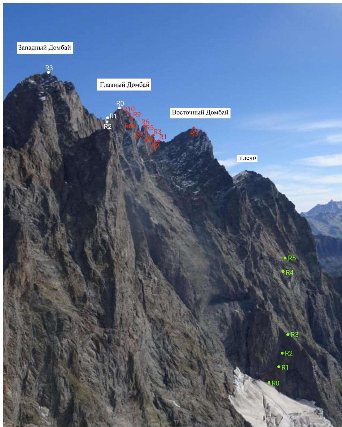
1.2. Profile of the traverse part of the route. Photo taken from the peak of Vostochnaya Dombay and from the overnight stay on the descent.
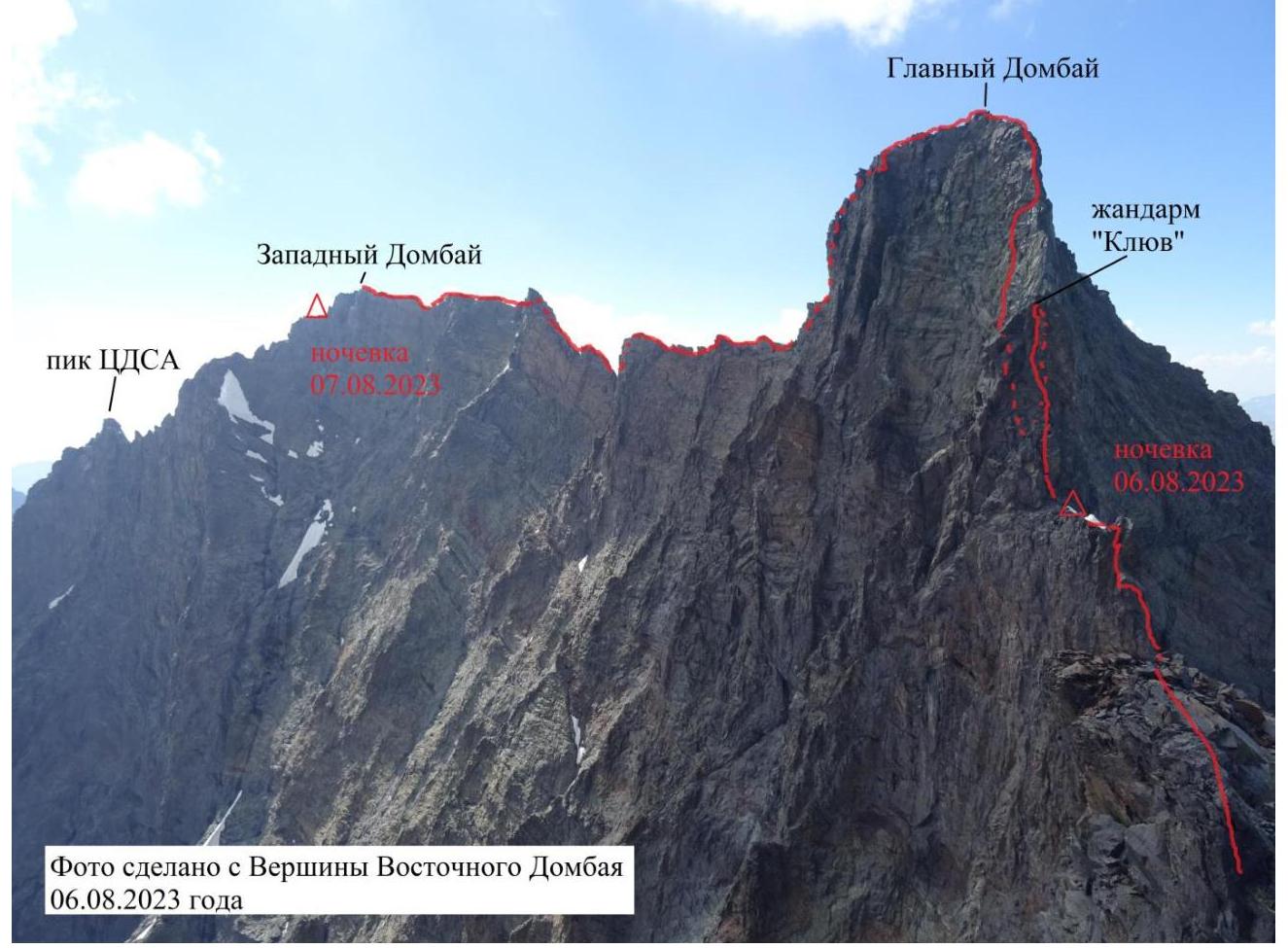 Photo taken from the peak of Vostochnaya Dombay on August 6, 2023.
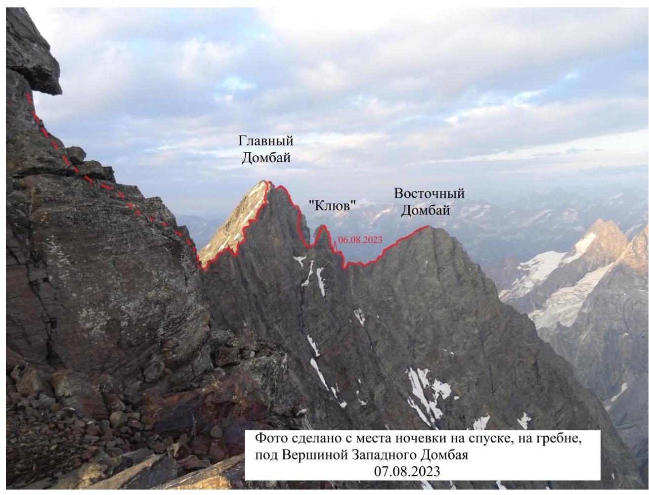 Photo taken from the overnight stay on the descent, on the ridge, under the peak of Zapadnaya Dombay on August 7, 2023.
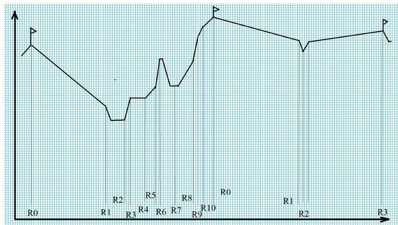
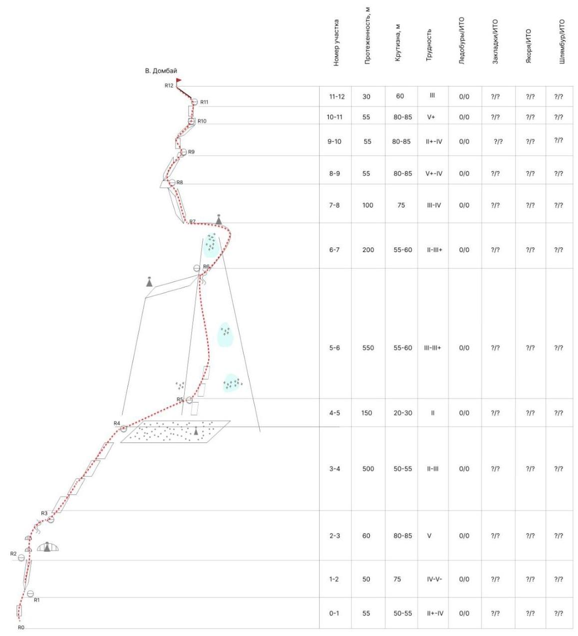
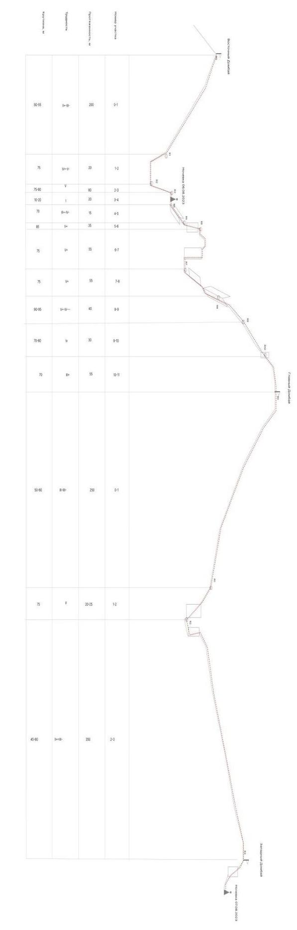
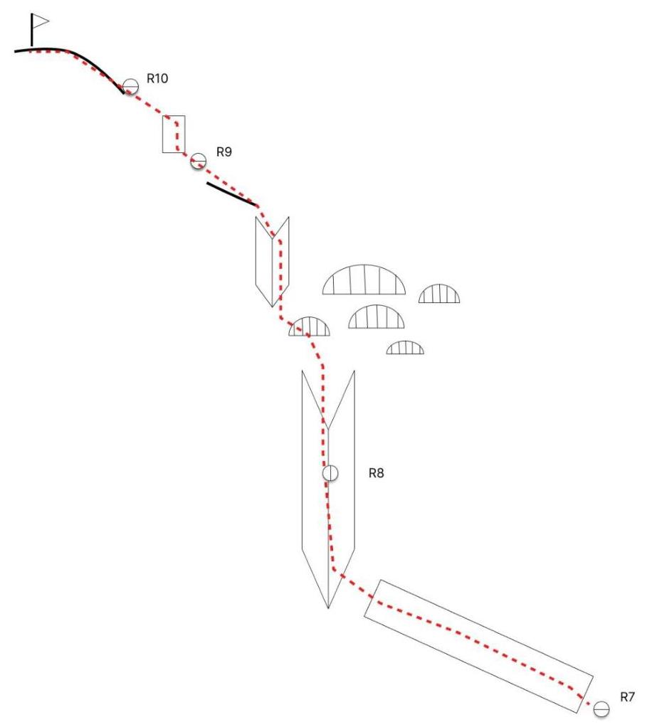
1.3. Hand-drawn profile of the route
1.4. Photopanorama of the area
 Photo taken from the ridge of the Nameless peak. If you look from the Klukhorsky Lake, the Nameless peak is to the left of the Klukhor-Bashi peak. Photo taken on September 8, 2022.
1.5. Map of the area.
Map-scheme of the Dombay area

Map-scheme taken from the book by Shipilov V. S. "Peaks of Dombay".
1.5. Approach routes
From the Dombay glade along the Dombay valley to the right of the Chuchkhir waterfalls along the trail to the Ptysh overnight stays — 2.5–3 hours.
From the Ptysh overnight stays along the moraine of the Ptysh glacier upwards for 15–20 minutes and to the left into a narrow long couloir towards the Dombay pass. Ascent through the couloir, then along the snowy slope and through the rocky gates — exit to the Dombay pass. Ascent time: 3 hours. Place for a bivouac.
From the pass along the couloir descent to the South-Dombay glacier and along it to the left down to the "ram's foreheads" opposite the southern wall of the Dombay peak (Vostochnaya). Place for a bivouac. From the pass — 0.5 hours.
From the bivouac to the right upwards into a small snowy-icy cirque at the base of the southern wall of Dombay (V). To the right remain large sheer walls with waterfalls, to the left a large step breaks off the mulda coming from under the peak of Dombay (Zapadnaya). Traversing the cirque, exit to the wall at the triangle of reddish destroyed rocks.
The description of the approach is taken from the book by Shipilov V. A. "Peaks of Dombay".
At the time of writing the report, it is possible to drive by car to the fork of Ptysh — Chuchkhir.
2. Characteristics of the route
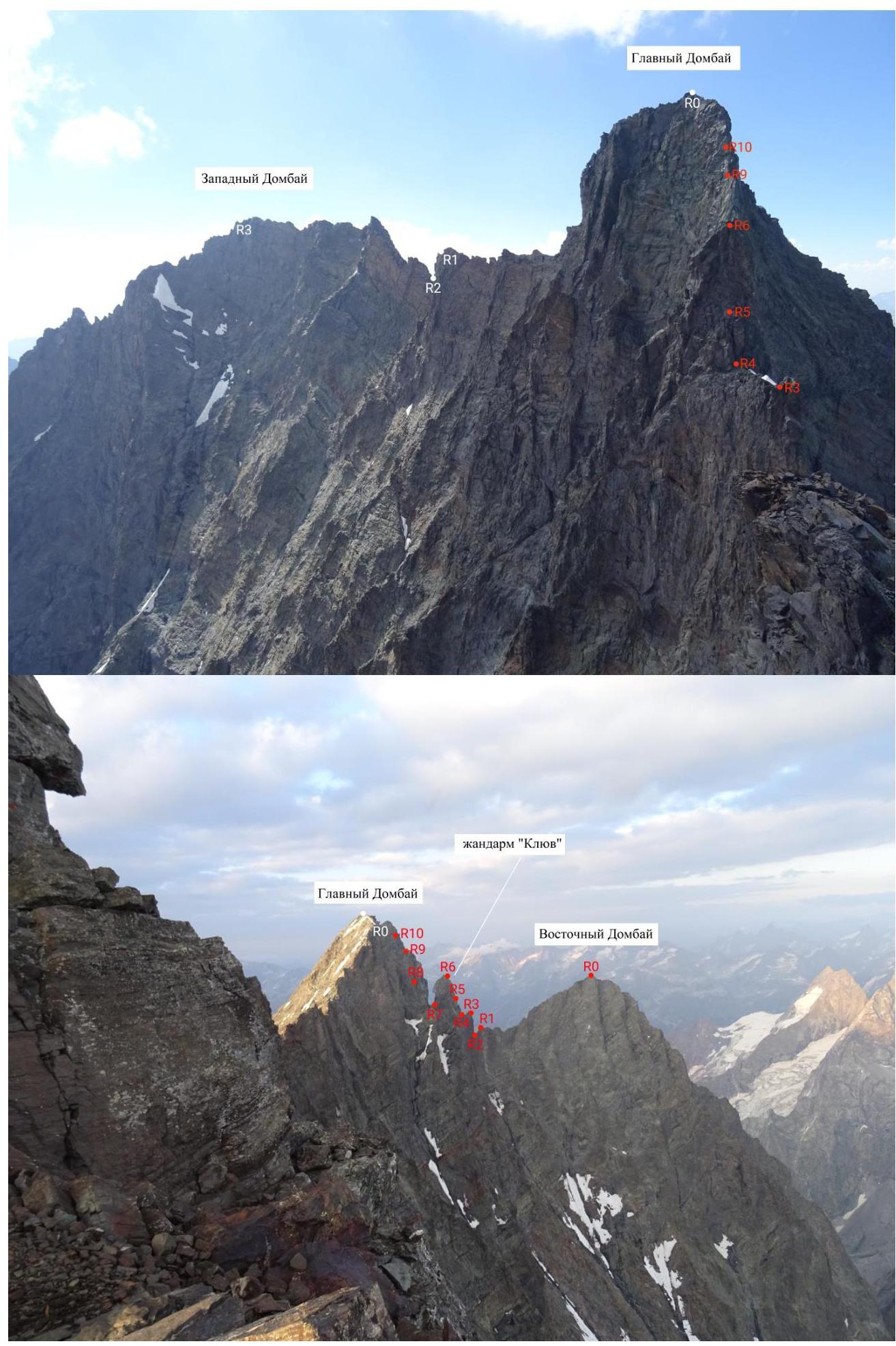
2.1. Technical photograph of the route.
 "Klyuv" gendarme
2.2. Outline of the route in UIAA symbols.
 Glavnaya Dombay
3. Characteristics of the team's actions
3.1. Brief description of the route by sections.
R0–R1 (50–55 m, 2+ – 4−, 50°–55°) — from the glacier through a small, uncomplicated rankluft exit to the wall. Along the partially destroyed rocks, partially with grass, to a wide internal angle with a crack, movement towards the cave. Simultaneously up to a comfortable ledge, further climbing is objectively more complex.
R1–R2 (45–50 m, 4 – 5−, 75°) — movement up the angle along its right part, mostly closer to the angle itself, to a comfortable ledge with three hooks. Comfortable station — the cave is visible from here. To the cave, up the simple rocks about 10 m. Further, the route goes without entering the cave along the left wall through overhangs straight up.
...
3.5. Tactical actions
Before the ascent, Semenov M. A. had climbed Vostochnaya Dombay several times. Once, he accidentally climbed a first ascent route 5B — a variant of the Kuzmin route, differing by more than 60%.
On September 5, 2020, in a team with Eliseev A. A., Semenov climbed the Gubanov route. After completing the ascent to the peak of Vostochnaya Dombay, they planned to traverse Vostochnaya — Zapadnaya Dombay. Due to worsening weather, the traverse had to be canceled. They chose a descent route along the Semenov variant on the southern wall.
The traverse was of interest to Semenov. Vvedenskaya had already climbed it with Semenov. Before this ascent, they jointly repeated the Eliseev — Gubanov route on the peak of Germansky Komsomol.
The Semenov — Vvedenskaya team made the third ascent of the route with the aim of submitting it for a higher classification. At the time of writing the report, the category of complexity of the route is 4B. In reality, this route deserves 5B category.
The Semenov — Vvedenskaya team made the third ascent of the route. The second ascent was made by Semenov in 2011. It turns out that since the first ascent, no one had climbed the route. Since Semenov knew the route, Varvara Vvedenskaya led the entire route. It became clear that Varvara is a reliable and well-prepared partner capable of reliably leading on complex sections.
The descent from Zapadnaya Dombay is carried out along the Sosorov route 4B. In autumn 2017, Semenov drilled stationary bolts for the descent from this route.
Semenov M. A. has a good knowledge of the area, the massif, approaches, and retreats.
3.6. Safety assessment of the route.
The Dombay area at the time of writing the report is long forgotten and abandoned, despite being frequently visited by tourists. An alpinist in these mountains is a rare creature.
One of the participants in the ascent, Semenov M. A., has extensive practical knowledge of the area and the massif. A description of this route was found in the book by Shipilov V. A. "Peaks of Dombay". To climb this route, one needs to have good physical fitness due to its great length. Also, due to the vast distances and scales, one needs to have a very good navigation skill. Due to the low frequency of visits to the route, this line is quite stone-hazardous.
The route is logical, interesting, and beautiful with its views. As a first 5B route, it is not recommended due to its great length, complexity in navigation, and the impossibility of an easy retreat in case of an emergency situation on most of the route.
Comments
Sign in to leave a comment