
Ascent Passport
-
Route type: Combined.
-
Climbing area: Pamir-Alay, Turkestan Range.
-
Object of ascent: Peak 4870 m.
-
Category of difficulty: 4A — category of difficulty (approximate), first ascent.
-
Route characteristics:
- Elevation gain: 580 m,
- Length of sections:
- 4th category of difficulty: 500 m,
- 3rd category of difficulty: 320 m,
- 2nd category of difficulty: 180 m,
- Average slope: 38 degrees.
-
Pitons hammered:
- Ice screws: 8.
-
Total climbing hours: 13 h.
-
Leader: Lobachev E. A. — Candidate Master of Sports, Participants:
- Alenina N. — 2nd sports category
- Lebedev A. — 2nd sports category
- Robozеров A. — 2nd sports category
-
Departure from base camp: August 9, 1995. Summit ascent: August 10, 1995. Return to base camp: August 11, 1995.
-
Sports group of the Sports Committee of St. Petersburg.
Peak Slesova (4240 m) Peak Baya (4800 m) Peak 3850 m
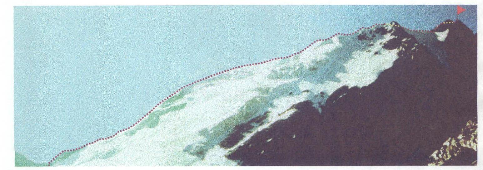
Photograph of the summit of Peak 4870 m.
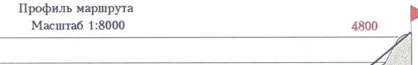
Route profile. Scale 1:8000. 4800 m.
- R14–R15
- R13–R14
- R12–R13
- R11–R12
- R10–R11
- R9–R10
- R8–R9
- R7–R8
- R6–R7
- R5–R6
- R4–R5
- R3–R4
- R2–R3
- R1–R2
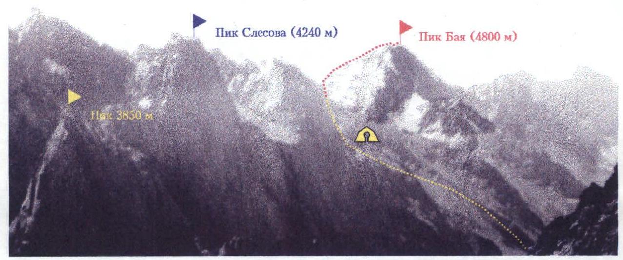
Photopanorama of the ascent area
- point of photography
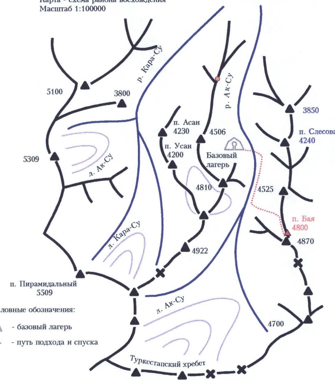
Map-scheme of the ascent area. Scale 1:100 000 Conventional signs:
- visible part of the route
- invisible part of the route
- bivouac
Analysis of the ascent to the northern summit of Peak 4870 m via the northern ridge (Peak Baya, first ascent), approximately 4A category of difficulty, August 12, 1995, base camp in the Ak-Su gorge
- August 9. Departure from base camp at 16:30 to an overnight stay in the pocket of the left moraine of the glacier in the upper cirque. 20:00 — setting up a bivouac.
- August 10. Departure from the overnight stay at 7:30 am. One hour ascent to the pass. We tie in on the saddle before exiting onto the snowy ridge. Further movement along the snowy ridge. The rope teams worked independently and simultaneously. Belaying was done through ice axes; in places where ice was exposed on the surface, ice screws were used, and the character of movement remained the same.
- 12:30 — the ridge flattens out, we exit into a snowy mulde in its upper part. Rest for about an hour. Further movement along a more gentle section, and we have to press against the rock outcrops on the left — large snowy cornices are on the right. On steep ascents of the ridge, alternating belays are used through ice axes and ice screws. Movement in crampons.
- The next section of the route passes along the rocky ridge, but there is a simple option to bypass it on the left along the scree shelves. After returning to the ridge, we exit under the steep icy ascent of the ridge, which is overcome in crampons using ice screws. Further, the ridge flattens out, the route leads to the base of the pre-summit rock tower, which we reach by 15:30. The tower is climbed with alternating belays. The rocks have a tiled structure and are heavily destroyed. Belaying is very difficult. A heavily destroyed rocky ridge leads to the summit tower, and a gendarme on it is bypassed on the left. The summit tower is climbed from left to right along steep, heavily destroyed rocks. A fixed rope is used in this section. By 16:30, the group reaches the summit.
- Descent is made along the ascent route. Descent is done in a sportsmanlike manner along a fixed rope, the last one descends with lower belay. Overnight stay in an intermediate camp in the upper cirque.
- August 11, 1995. Return to base camp in the Ak-Su gorge.
- Lobachev E. — leader: the first attempt to climb the summit of Peak 4870 m was made in July 1994. Then we were only able to overcome the snow-ice ridge, which is the beginning of the route. Since the attempt was made directly from the base camp, without an intermediate overnight stay, the group did not have enough daylight to complete the ascent. It was necessary to set up an intermediate camp in the upper cirque to ensure the necessary time reserve. The group completed the ascent to the northern summit, reaching a height of approximately 4800 meters. Further movement along the ridge towards the southern summit is considered impractical due to the increased danger caused by the impossibility of reliable belaying on the heavily destroyed rocky terrain. As the rightful first ascenders, the group proposes to name the summit "Peak Baya" in memory of a friend who died in 1994, who had the nickname "Bay". The route generally corresponds to the 4B category of complexity. I have no complaints about the participants of the ascent; everyone worked technically and tactically competently.
- Alenina N. — participant: the ascent and leadership were liked. The group's actions were coordinated.
- Lebedev A. — participant: the route is interesting, generally liked, but belaying on the rocky sections was very difficult.
- Robozеров A. — participant: generally agrees with the opinions of the other group members.
Senior coach of the gathering Odintsov A. N. Head of the rescue team Notankin I. V. Lobachev E. A. — leader of the ascent Participants of the ascent:
- Alenina N. V.
- Lebedev A. Yu.
- Robozеров A. V.
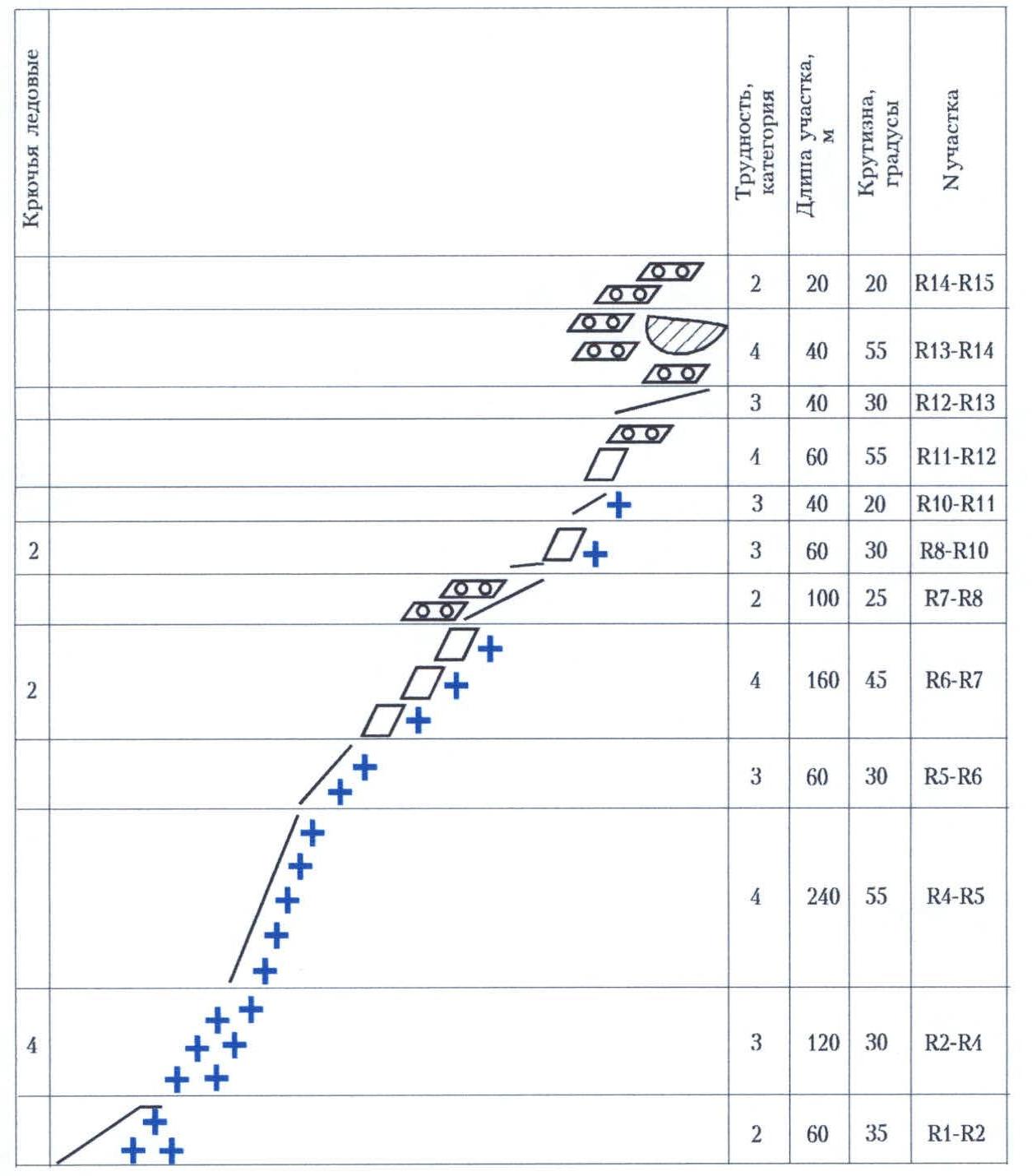
Route scheme in UIAA symbols
Scale 1:8000
| Section | Difficulty, category | Length of section, m | Slope, degrees | Ice screws |
|---|---|---|---|---|
| R14–R15 | 2 | 20 | 20 | |
| R13–R14 | 4 | 40 | 55 | |
| R12–R13 | 3 | 40 | 30 | |
| R11–R12 | 4 | 60 | 55 | |
| R10–R11 | 3 | 40 | 20 | 2 |
| R8–R10 | 3 | 60 | 30 | |
| R7–R8 | 2 | 100 | 25 | 2 |
| R6–R7 | 4 | 160 | 45 | |
| R5–R6 | 3 | 60 | 30 | |
| R4–R5 | 4 | 240 | 55 | |
| R2–R4 | 3 | 120 | 30 | 4 |
| R1–R2 | 2 | 60 | 35 |
Description of the route by sections
| Section | Description |
|---|---|
| R0–R1 | From overnight stays on the moraine of the upper cirque, 1 hour ascent along the glacier to the pass (crampons). |
| R1–R2 | One and a half to two ropes of the destroyed rocky ridge, approximately 2nd category, which can be bypassed on the right along a steep snow slope to a snowy saddle. |
| R2–R3 | Two ropes of a gentle, not clearly defined snowy ridge. |
| R3–R4 | Exit to a pronounced snowy ridge between the summits of ice seracs (ice axes, crampons). (One rope). |
| R4–R5 | Six ropes along a system of steep snowy ridges of variable steepness to a clearly pronounced flattening of the ridge. |
| R5–R6 | One and a half to two ropes of a gentle snowy ridge to rock outcrops. |
| R6–R7 | Three ascents of the snowy ridge with a total length of four ropes. Move along the rocks — snowy cornices are on the right. |
| R7–R8 | Two to two and a half ropes of the rocky ridge are bypassed on the left along scree shelves. |
| R8–R9 | Exit to a snowy-scree saddle. (One rope). |
| R9–R10 | Half a rope of a steep snowy-icy ascent of the ridge. |
| R10–R11 | One rope along the ridge to the base of the rocky tower. |
| R11–R12 | Half a rope of climbing steep, heavily destroyed rocks, then one rope along a system of scree shelves to the summit of the tower. |
| R12–R13 | One rope along the ridge to the base of the summit tower. (The gendarme on the ridge is bypassed on the left). |
| R13–R14 | One rope along the summit tower from left to right along steep, heavily destroyed rocks. |
| R14–R15 | Exit to the summit. (Half a rope along gentle, destroyed rocks). |