Ascent Passport
- Ascent class: technical
- Ascent area: D-3 Pamir, North Shugnan Ridge
- Peak, its height, ascent route: p. 4900 m via the center of the NW wall.
- Estimated difficulty category: 5A
- Route characteristics: height difference — 840 m, average steepness — 58°, section lengths: R1–5 m, R2–100 m, R3–350 m, R4–310 m, R5–295 m, R6–35 m
- Pitons hammered: for belay: rock — 92, ice — , bolt — ; for creating artificial holds: rock — 3, ice — , bolt — , chocks — 2.
- Number of travel hours — 16.
- Number of nights on the route and their characteristics: non-stop ascent.
- Surname, name, patronymic of participants, their qualification:
- CHERNYAEV Yuri — 1st sports category;
- GUROV Vladimir Nikolaevich — 1st sports category.
- Team coach: KENSITSKY Leopold Vsevolodovich — Master of Sports of the USSR.
- Date of departure and return: July 9, 1978 — July 10, 1978
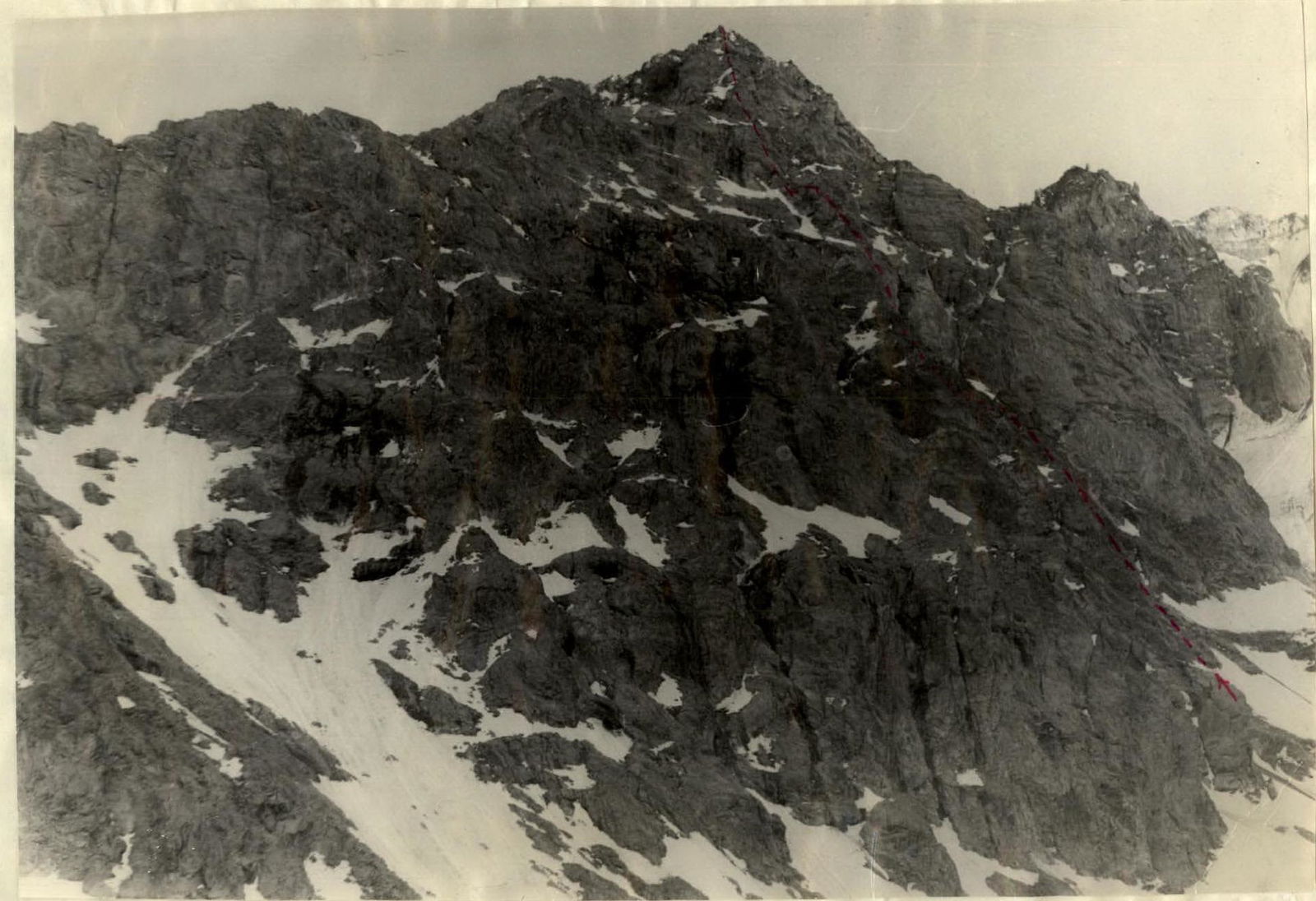
- route via the center of the NW wall
- route via the NW wall through the big gendarme
- descent via the northern ridge
Brief description of the approach to the route. Peak 4900 is located in the northern spur of peak Vodzh, which is situated in the North Shugnan Ridge (South-Western Pamir). The approach to the route is made from the base camp. The camp is located near the Khorog-Osh road (58 km from Khorog) by the Gunt River. There are sources of drinking water. Nearby are the villages of Vir and Shtam. Due to the presence of the road, there are conditions for communication with Khorog and Osh.
From the base camp on the left bank of the Gunt River, follow the trail up the Bistokh gorge to the moraine between peak 4900 and peak 5204. The approach takes 3 hours. Here:
- there are good areas for overnight stays;
- there is drinking water.
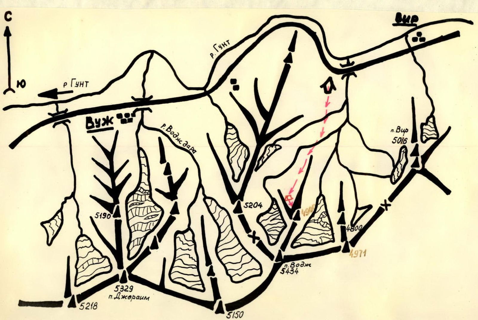
Map of the ascent area
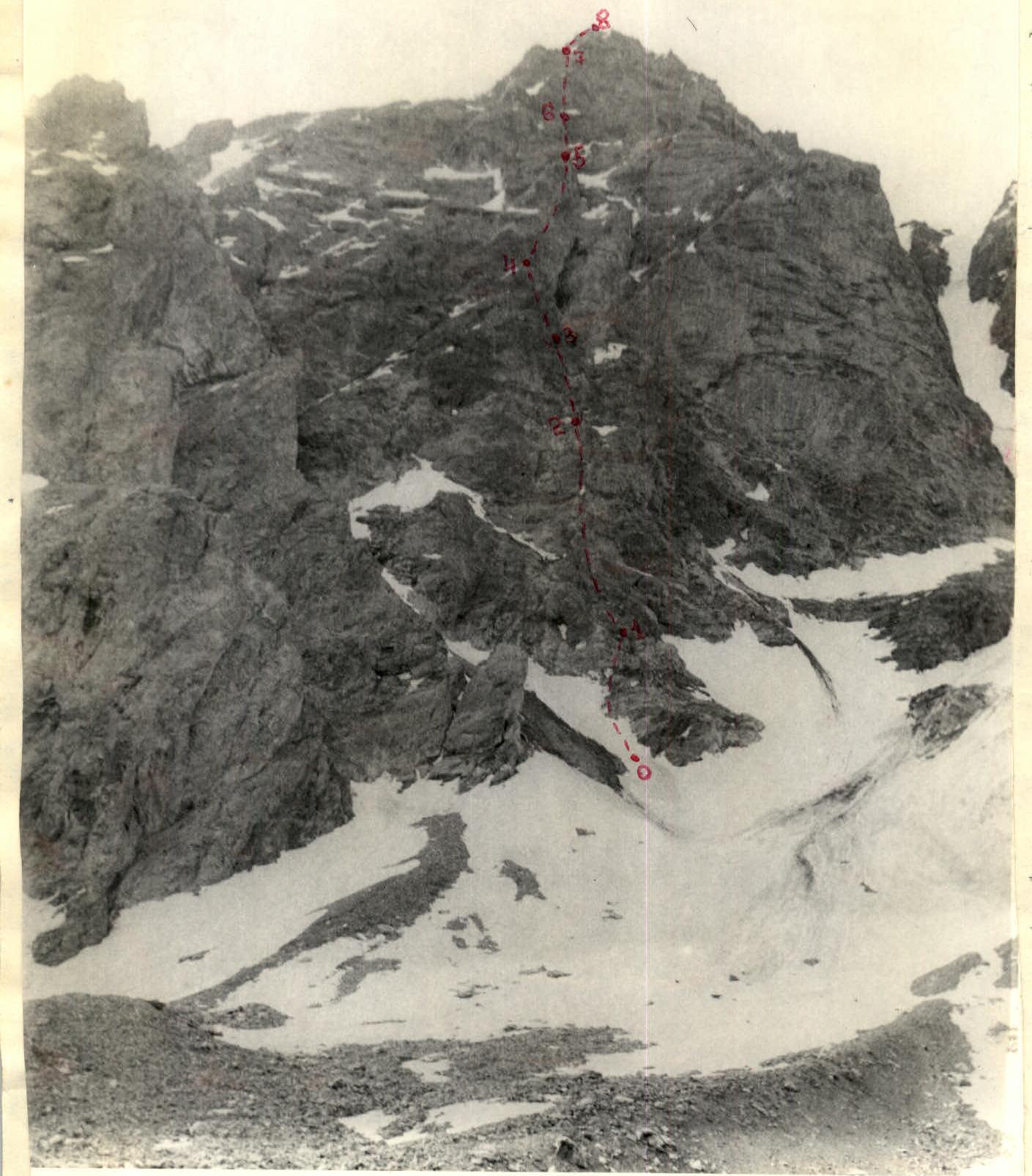
Table of main route characteristics
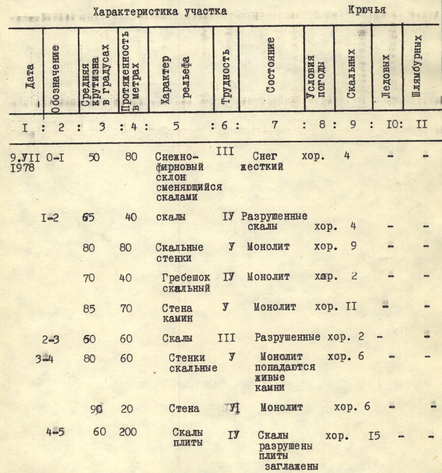
| Date | Designation | Average steepness in degrees | Length in meters | Terrain characteristics | Difficulty | Condition | Weather conditions | Rock | Ice | Bolt |
|---|---|---|---|---|---|---|---|---|---|---|
| July 9, 1978 | R0–R1 | 50 | 80 | Snow-firn slope turning into rocks | 3 | Hard snow | good | 4 | – | – |
| R1–R2 | 65 | 40 | Rocks | 4 | Broken rocks | good | 4 | – | – | |
| 80 | 80 | Rock walls | 5 | Monolith | good | 9 | – | – | ||
| 70 | 40 | Rocky ridge | 4 | Monolith | good | 2 | – | – | ||
| 85 | 70 | Chimney wall | 5 | Monolith | good | 11 | – | – | ||
| R2–R3 | 60 | 60 | Rocks | 3 | Broken | good | 2 | – | – | |
| R3–R4 | 80 | 60 | Rock walls | 5 | Monolith, loose rocks | good | 6 | – | – | |
| 90 | 20 | Wall | 5 | Monolith | good | 6 | – | – | ||
| R4–R5 | 60 | 200 | Slabby rocks | 4 | Rocks broken, slabs smoothed | good | 15 | – | – | |
| July 9, 1978 | R5–R6 | 85 | 45 | Wall | 5 | Monolith | good | 14 | – | – |
| 95 | 15 | Wall | 6 | Monolith | good | 6 | – | – | ||
| R6–R7 | 45 | 100 | Rocky ledges | 3 | Broken | satisfactory | 3 | – | – | |
| 50 | 50 | Rocky ridge | 4 | Broken | satisfactory | 3 | – | – | ||
| 70 | 40 | Wall | 5 | Broken | satisfactory | 6 | – | – | ||
| 40 | 110 | Rocky ledges, ridges | 3 | Broken | satisfactory | 5 | – | – | ||
| R7–R8 | 15 | 100 | Rocky ridge, gendarmes | 2 | Severely broken | satisfactory | – | – | – |
Departure for the route — 5:00. Arrival at the summit — 17:00. Time taken to cover sections R0–R8 — 12 hours. Descent via the big gendarme and then along the northern ridge — 4 hours. During the ascent, 85 rock pitons were hammered for belay, 7 ice pitons; 5 artificial holds were created, including chocks.
Brief explanation of the table.
Peak "4900 m" is located in the North Shugnan Ridge, in the north-eastern spur of peak Vodzh. The route is mostly rocky. However, the beginning of the route is on a snow slope, the steepness of which gradually increases to 50°. Then, traversing to the right leads to the rocks. Further, the route passes through the central part of the north-west wall, which is initially separated from the rest of the massif:
- by a small couloir on the right;
- by a long couloir reaching the gap between the Big Gendarme and the summit — on the left.
Then, it continues to the pre-summit ridge, along which, without significant ascent, it reaches the summit. By its nature, the entire route can be divided into the following sections:
- R0–R1 — Snow slope and gentle rocks;
- R1–R2 — First ascent;
- R2–R3 — Belt of broken rocks;
- R3–R4 — Second ascent;
- R4–R5 — Belt of inclined slabs;
- R5–R6 — Gendarme;
- R6–R7 — Pre-summit belt;
- R7–R8 — Pre-summit ridge.
Below is a description of the route with detailed indications of the characteristic sections of the ascent path.
R0–R1. From the overnight stay location on the moraine, move along the snow slope towards the north-west wall of peak "4900" (1 hour). In the upper part, the snow slope is steep, movement is "in three steps", belay via ice axe. Traversing to the right leads to the rocks. Then, straight up along the destroyed inner corner (40 m, 1).
R1–R2. Along the rocky walls with ledges (the right side of which steeply drops into the couloir) — exit to the ridge (80 m, difficult climbing). Initially, movement is along the ridge (40 m), then it becomes steeper and the route turns left onto the wall. In the upper part of the wall, there is a small chimney that leads to a ledge in front of the broken rocks (70 m, difficult climbing). Along the broken rocks straight up (60 m), belay via outcrops, to the steep ascent. Along the steep monolithic rocks towards the dark wall (60 m). The dark wall is passed from left to right (20 m), climbing is very difficult, artificial holds are used. Then, along the ledges — exit to the scree shoulder (control cairn). From the scree shoulder, along smoothed slabs alternating with gentle rock sections, move left towards the gendarmes in front of the ridge separating the summit and the "Big Gendarme".
R5–R6. The route passes through the middle of the three adjacent gendarmes. The gendarme is cut by a vertical slit, which has a branch to the left in its upper part, passing through overhanging rocks. Very difficult climbing, chocks are used as artificial holds.
R7–R8. From the gendarme straight up to the scree ledges. On the left remains the powerful ridge between the "Big Gendarme" and the summit. Then, along severely broken rocks — towards the pre-summit ridge. Along the simple rocks of the pre-summit ridge without significant ascent — to the summit.
Descent from the summit — via the Big Gendarme.
- Along the wall of the ridge separating the Big Gendarme from the summit, descend into the gap (3 rappels of 40 m, 2 bolt pitons were hammered; due to a large number of falling stones, the descent was made "obliquely"), 2 sports rappels of 40 m.
- Then, along broken rocks — ascent to the Big Gendarme.
- Descent from the Big Gendarme to the northern ridge is also made via rappel (40 m).
- Along the simple northern ridge — to the base camp.