-
Ascent class: technical
-
Ascent area: D-3 Pamir, North Shugnansky Ridge
-
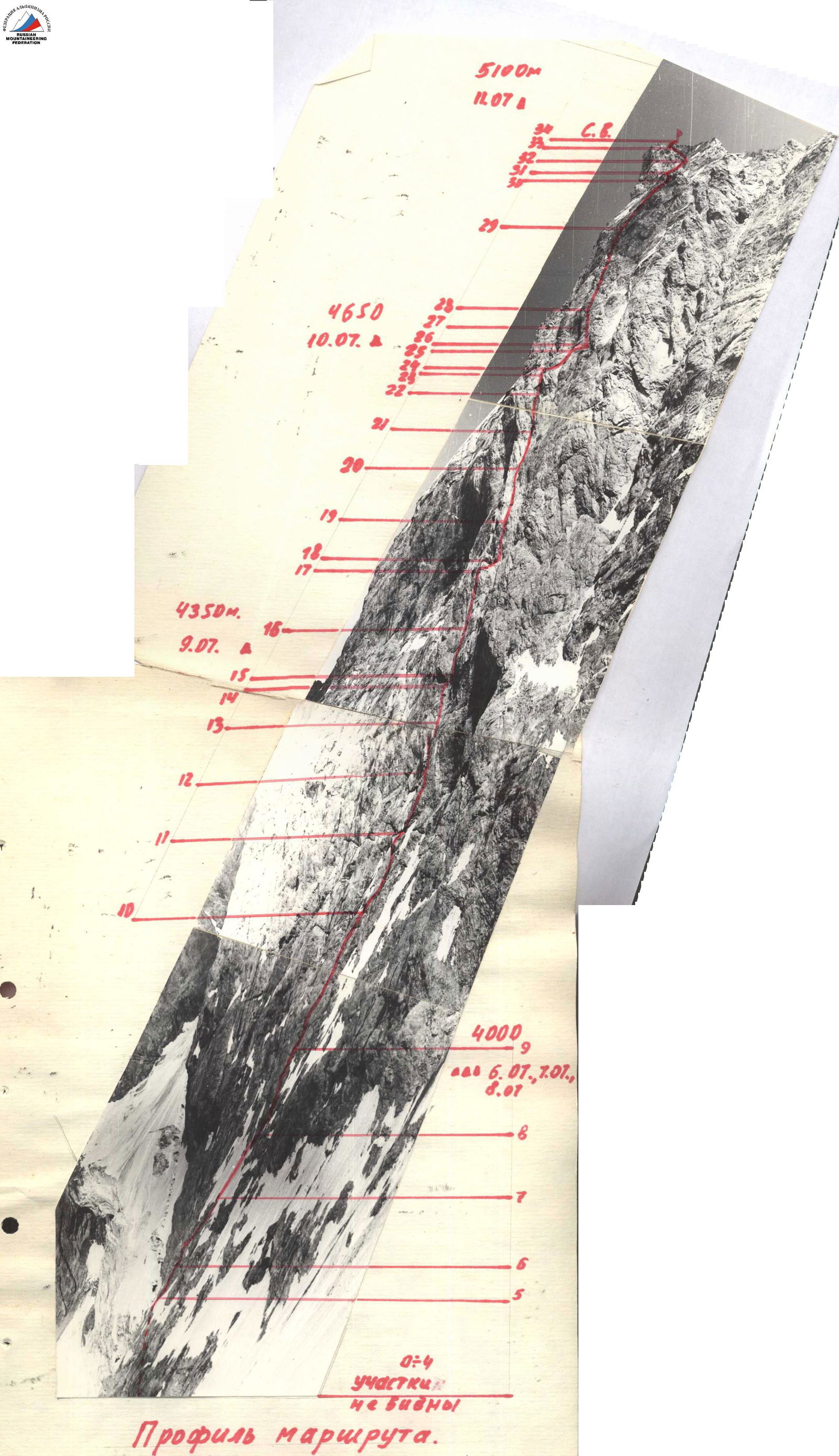
Peak, its height, ascent route: p. 5204 m via North face
-
Proposed category of complexity: 6
-
Route characteristics: height difference — 1350 m length of sections 5–6 cat. diff. — 920 m average steepness — 70° Gordarak
-
Pitons hammered: for belaying: rock — 195 ice — 36 bolt — 9 for creating ITO: rock — 38 ice — 7 bolt — 1
-
Number of walking hours: 44.5 hours
-
Number of overnight stays and their characteristics: 4 overnight stays. 3 — separate ledges for 1–2 people sitting and half-lying, 1 — on the ridge in a tent.
-
Surname, name, patronymic of the team leader, participants, their qualification: team leader Grishchenko V.I., CMS, instr., participants:
- Samoded A.A., MS, instr.,
- Stavnitser A.M., CMS, instr.,
- Zasypkin V.V., CMS,
- Vasilenko V.I., CMS,
- Boyko V.G., CMS, instr.,
- Slavinsky P.F., CMS, instr.,
- Grishchenko V.A., CMS, instr.
-
Team coach: Kensitsky Leopold Vsevolodovich
-
Date of departure and return: July 4–12, 1978
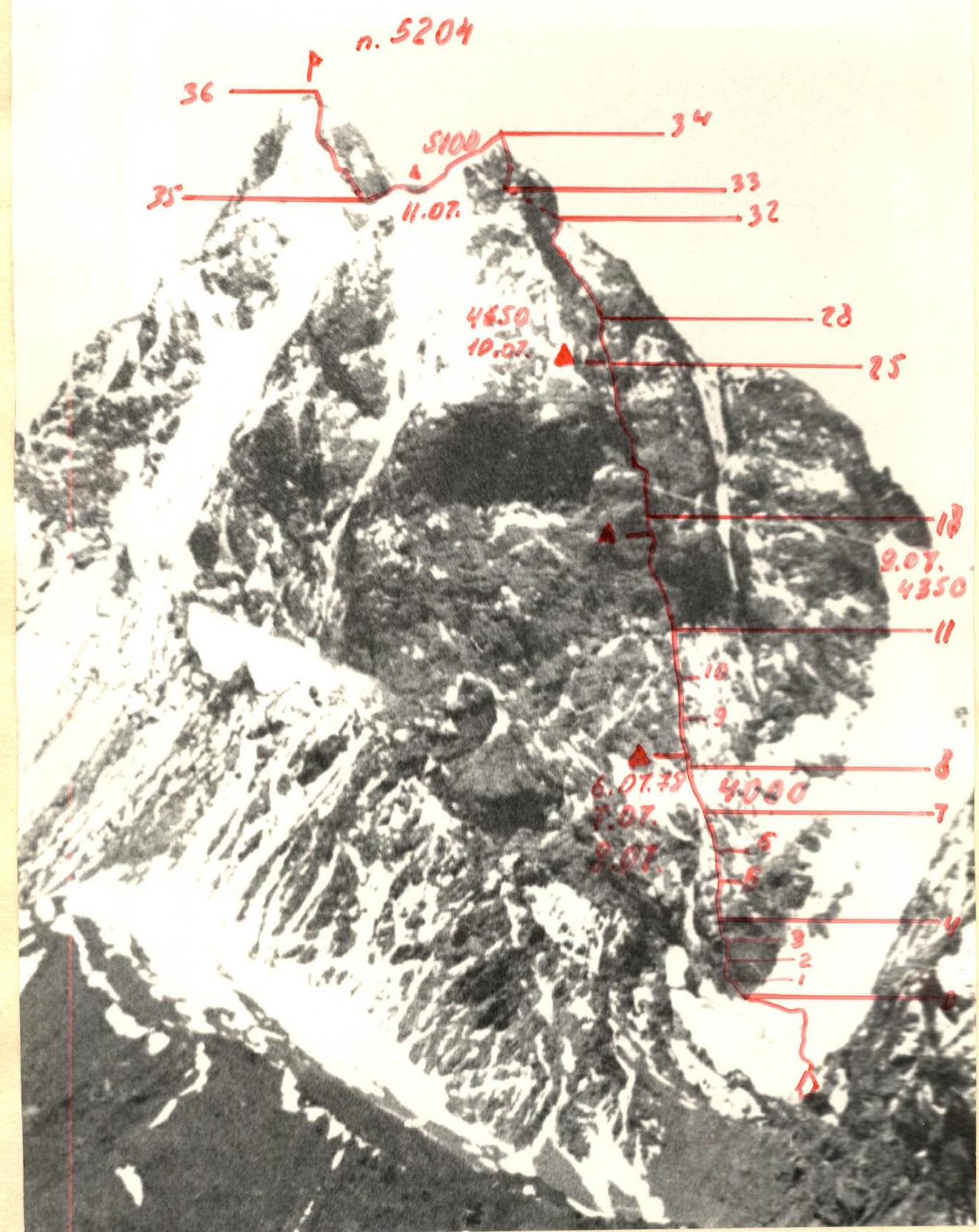
TABLE OF MAIN CHARACTERISTICS OF THE ASCENT ROUTE
Ascent route: p. 5204 via North face, approximately 6B cat. diff.
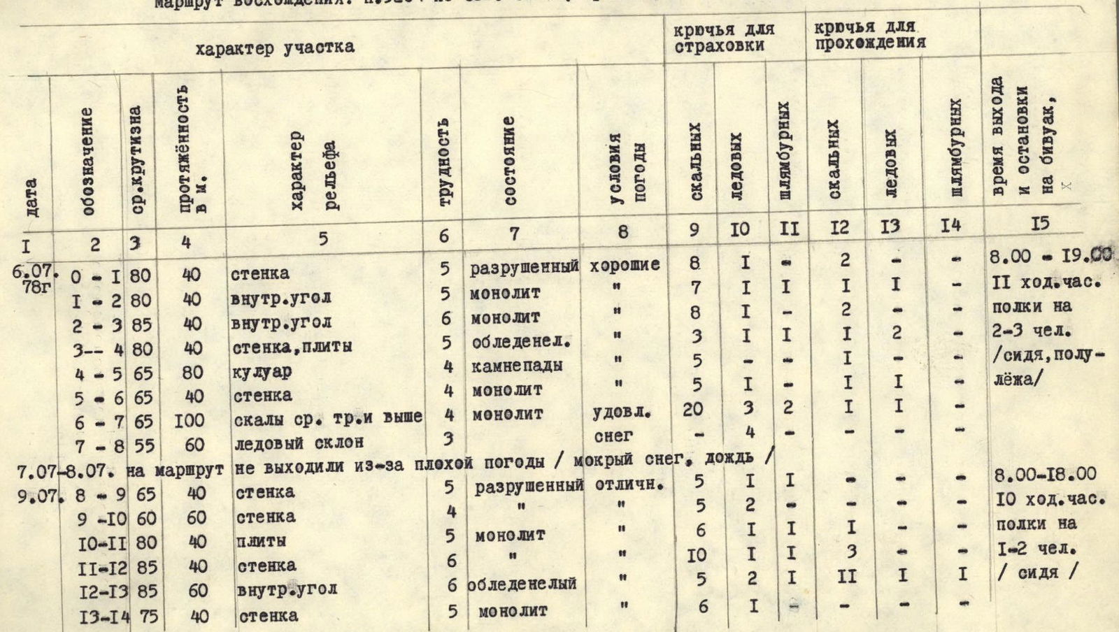
| Date | Designation | Average steepness | Length, m | Terrain characteristics | Difficulty | Condition | Weather conditions | Pitons for belaying: rock | Pitons for belaying: ice | Pitons for belaying: bolt | Pitons for passing: rock | Pitons for passing: ice | Pitons for passing: bolt | Time of departure and arrival at bivouac |
|---|---|---|---|---|---|---|---|---|---|---|---|---|---|---|
| July 6, 1978 | R0–R1 | 80 | 40 | wall | 5 | destroyed | good | 8 | 1 | - | 2 | - | - | 8:00–19:00 |
| R1–R2 | 80 | 40 | inner angle | 5 | monolith | " | 7 | 1 | 1 | 1 | 1 | - | ||
| R2–R3 | 85 | 40 | inner angle | 6 | monolith | " | 8 | 1 | - | 2 | - | - | 11 hours walking | |
| R3–R4 | 80 | 40 | wall, slabs | 5 | icy | " | 3 | 1 | 1 | 1 | 2 | 1 | ledges for 2–3 people (sitting, half-lying) | |
| R4–R5 | 65 | 80 | couloir | 4 | rockfall | " | 5 | - | - | 1 | - | - | ||
| R5–R6 | 65 | 40 | wall | 4 | monolith | " | 5 | 1 | - | 1 | 1 | - | ||
| R6–R7 | 65 | 100 | rocks of medium difficulty and higher | 4 | monolith | satisfactory | 20 | 3 | 2 | - | - | - | ||
| R7–R8 | 55 | 60 | ice slope | 3 | - | snow | - | 4 | - | - | - | - | ||
| July 7-8, 1978 | did not go on the route due to bad weather / wet snow, rain / | |||||||||||||
| July 9, 1978 | R8–R9 | 65 | 40 | wall | 5 | destroyed | excellent | 5 | 1 | - | 1 | - | - | 8:00–18:00 |
| R9–R10 | 60 | 60 | wall | 4 | " | " | 5 | 2 | - | - | - | - | 10 hours walking | |
| R10–R11 | 80 | 40 | slabs | 5 | monolith | " | 6 | 1 | 1 | 1 | - | - | ledges for 1–2 people (sitting) | |
| R11–R12 | 85 | 40 | wall | 6 | icy | " | 10 | 1 | 1 | 3 | 1 | 1 | ||
| R12–R13 | 85 | 60 | inner angle | 6 | monolith | " | 5 | 2 | 1 | 11 | 1 | - | ||
| R13–R14 | 75 | 40 | wall | 5 | monolith | " | 6 | 1 | - | - | - | - | ||
| July 10, 1978 | R14–R15 | 90 | 30 | traverse of the wall | 6 | destroyed | excellent | 6 | 1 | - | 3 | - | - | 8:00–19:30 |
| R15–R16 | 75 | 40 | inner angle | 6 | " | " | 4 | 1 | - | 4 | 1 | - | ||
| R16–R17 | 80 | 40 | wall | 5 | monolith | " | 8 | 1 | - | - | - | - | ||
| R17–R18 | - | 30 | ledge, traverse | 3 | destroyed | " | 2 | 1 | - | - | - | - | ||
| R18–R19 | 85 | 40 | wall | 6 | monolith | " | 4 | 1 | 1 | 2 | 1 | - | 11 hours 30 minutes | |
| R19–R20 | 75 | 40 | wide inner angle | 5 | " | " | 4 | 1 | - | - | - | - | artificial | |
| R20–R21 | 80 | 40 | inner angle with overhanging wall | 5 | " | " | 5 | - | - | 1 | - | - | ledges for 1–2 people, hammocks | |
| R21–R22 | 80 | 40 | chimney | 5 | " | " | 2 | - | - | - | - | - | ||
| R22–R23 | 85 | 40 | wall | 5 | " | " | 6 | 1 | - | - | - | - | ||
| R23–R24 | 110 | 10 | overhanging wall | 6 | " | " | 1 | 1 | - | 2 | - | - | ||
| R24–R25 | 80 | 60 | groove | 5 | wet | " | 10 | 1 | - | - | - | - | ||
| R25–R26 | - | 70 | traverse | 4 | destroyed | " | 5 | 1 | - | - | - | - | ||
| July 11, 1978 | R26–R27 | 60 | 40 | rocks of medium difficulty | 3 | " | " | 2 | - | - | - | - | - | 9:00–20:00 |
| R27–R28 | 70 | 40 | inner angle | 5 | " | " | 6 | - | - | - | - | - | 12 hours walking | |
| R28–R29 | 80 | 120 | wall | 5 | monolith | " | 16 | 2 | - | 2 | - | - | ledges on the ridge, tents | |
| R29–R30 | 60 | 120 | wall | 4 | destroyed | " | 12 | 2 | - | - | - | - | ||
| R30–R31 | 30 | 120 | ridge | 2 | " | - ledges | simultaneous | - | - | - | - | - | ||
| R31–R32 | - | 60 | traverse | 3 | " | " | 3 | - | - | - | - | - | ||
| R32–R33 | 60 | 60 | couloir, ice | 4 | rockfall | " | 3 | - | - | - | - | - | ||
| R33–R34 | 65 | 60 | wall | 4 | destroyed | " | 3 | - | - | - | - | - | ||
| R34–R35 | 30 | 200 | snow ridge | 2 | " | " | simultaneous | - | - | - | - | - | ||
| R35–R36 | 40 | 200 | slab-like rocks | 3 | snow, ice | " | 10 | 2 | - | - | - | - |
Explanations
to the table of main characteristics of the ascent route.
Section R0–R1. The wall is composed of gray granite blocks with vertical cracks, destroyed in the lower part. Move in the direction of the inner angle. In the upper part of the wall, holds are smoothed. Difficult climbing.
Section R1–R2. Inner angle with smoothed holds, few cracks. Difficult climbing.
Section R2–R3. Inner angle, monolithic rocks, wet in the upper part. In some places, overhanging sections of 2–3 m. Difficult climbing.
Section R3–R4. Ascend upwards under the waterfall, move to the left side of the waterfall. Rocks are wet (icy in the morning).
Section R4–R5. Go straight up the rocks like "ram's foreheads" to approach under the couloir, cross the couloir to the right, then move upwards along the couloir along smoothed slabs.
Section R5–R6. Straight up the destroyed rocks of block type.
Section R6–R7. Up along the couloir, climbing of medium difficulty, ledges and vertical walls up to 10–Section 6.
Section R7–R8. Snow-ice slope, belay on ice screws, exit to destroyed rocks.
Section R8–R9. Destroyed rocks, ledges filled with gravel, overnight stays sitting, half-lying.
Section R9–R10. Granite blocks, trace ice in cracks.
Section R10–R11. Monolithic rocks with few cracks, difficult climbing.
Section R11–R12. Up to the left along monolithic rocks under the inner angle. Rocks have almost no cracks, few holds. Very difficult climbing.
Section R12–R13. Large inner angle. Wet, partially icy, live rocks. Very difficult climbing with application of artificial holds. Channel hooks, cams, and sling nuts.
Section R13–R14. Up the wall with good holds for 25 m, then traverse to the right for 15 m under the destroyed cornice.
Section R14–R15. Along the cornice upwards (very difficult climbing), then traverse to the right to a scree ledge in the inner angle. Rockfall!
Section R15–R16. Inner angle, overhanging in the upper part. Ice, live rocks. Difficult climbing, rockfall! Ledge, overnight stay for 2 people sitting.
Section R16–R17. Monolithic rocks with good holds, exit to a ledge. Overnight stays for 2 people sitting.
Section R17–R18. Traverse along a destroyed ledge to a dent (30 m). Rockfall hazard!
Section R18–R19. Monolithic wall with few holds. Very difficult climbing. In the upper part, transition to the left to the base of a wide inner angle.
Section R19–R20. Wide inner angle with a crevice. Holds are smoothed. Difficult climbing.
Section R20–R21. Inner angle, overhanging wall in the upper part with many holds. Difficult climbing.
Section R21–R22. Narrow chimney, live rocks in the upper part.
Section R22–R23. Vertical wall of medium blocks, traverse 5 m to the right under an overhanging wall.
Section R23–R24. Overhanging wall 10 m, difficult climbing with ITO application. Ledge above, possible overnight stay for 2–3 people.
Section R24–R25. Along the ledge to the right for 10 m, then up the groove for 50 m to the left side of the couloir. Inclined ledge for 1–2 people. Very difficult climbing.
Section R25–R26. Traverse to the right, crossing the couloir, to a rocky shoulder. Possible overnight stays for 3–4 people on artificial ledges.
Section R26–R27. From the shoulder, directly up along destroyed rocks into the inner angle, live rocks.
Section R27–R28. Along the inner angle, and then up to the left along the wall to a small dent. Rockfall! Difficult climbing.
Section R28–R29. From the dent, difficult exit to the right onto the wall, up the wall to the left to destroyed rocks. Difficult climbing.
Section R29–R30. Destroyed wall leading to a simple ridge. Live rocks!
Section R30–R31. Ridge, and then a snow slope leading under the base of a large gendarme.
Section R31–R32. Traverse to avoid the gendarme (to the right). Exit to a couloir leading to a pass between the North peak and the gendarme.
Section R32–R33. Up the couloir to the pass. Rockfall hazard!
Section R33–R34. Wall of block type, partially live rocks, climbing of medium difficulty. Exit to the North peak.
Section R34–R35. Descent to the pass between the North and Central peaks along a gentle snow ridge. Cornices!
Section R35–R36. Ascent to the peak along snow-covered slab-like rocks, climbing of medium difficulty, partially trace ice.
Descent to the side of the pass (back), then down a narrow snow couloir to the west into the VodzhdaRa valley and further along the valley to the Horog — Osh highway.
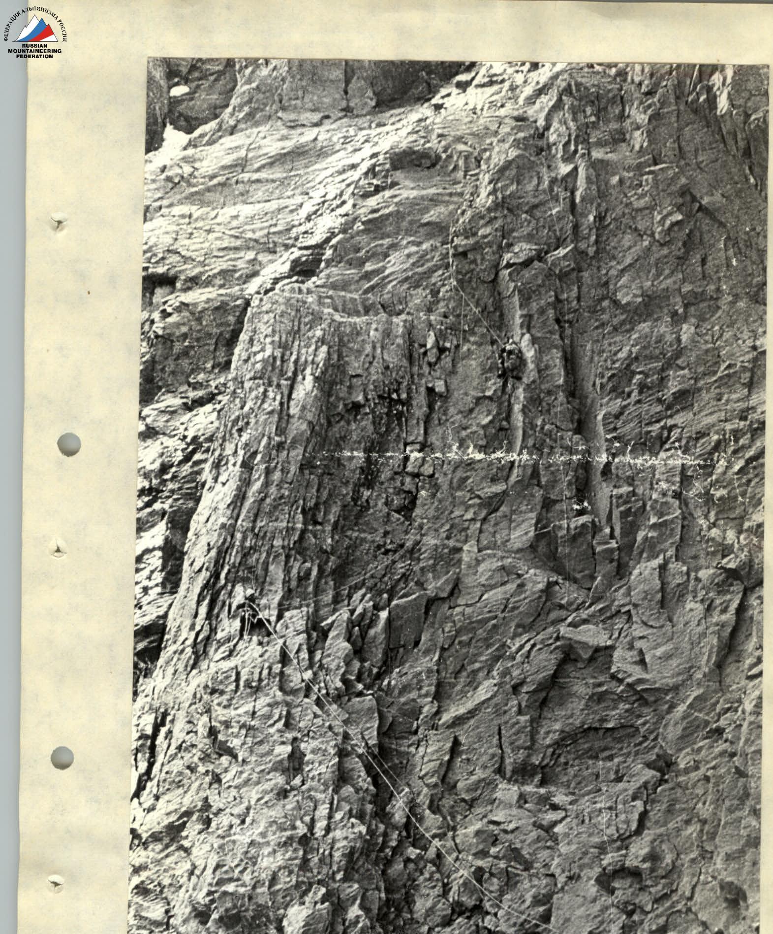
On sections R0–R3.
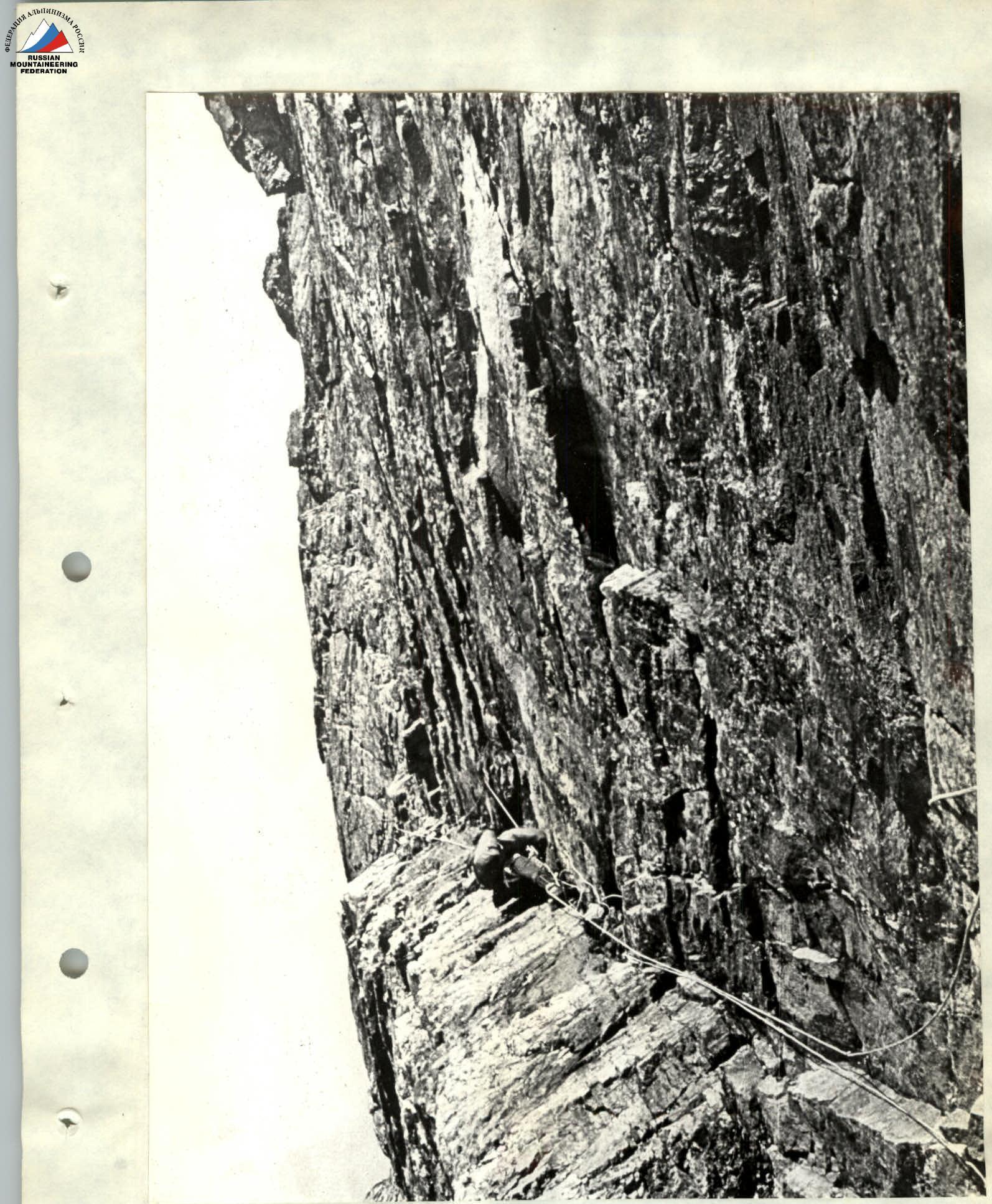
On section R12–R13.
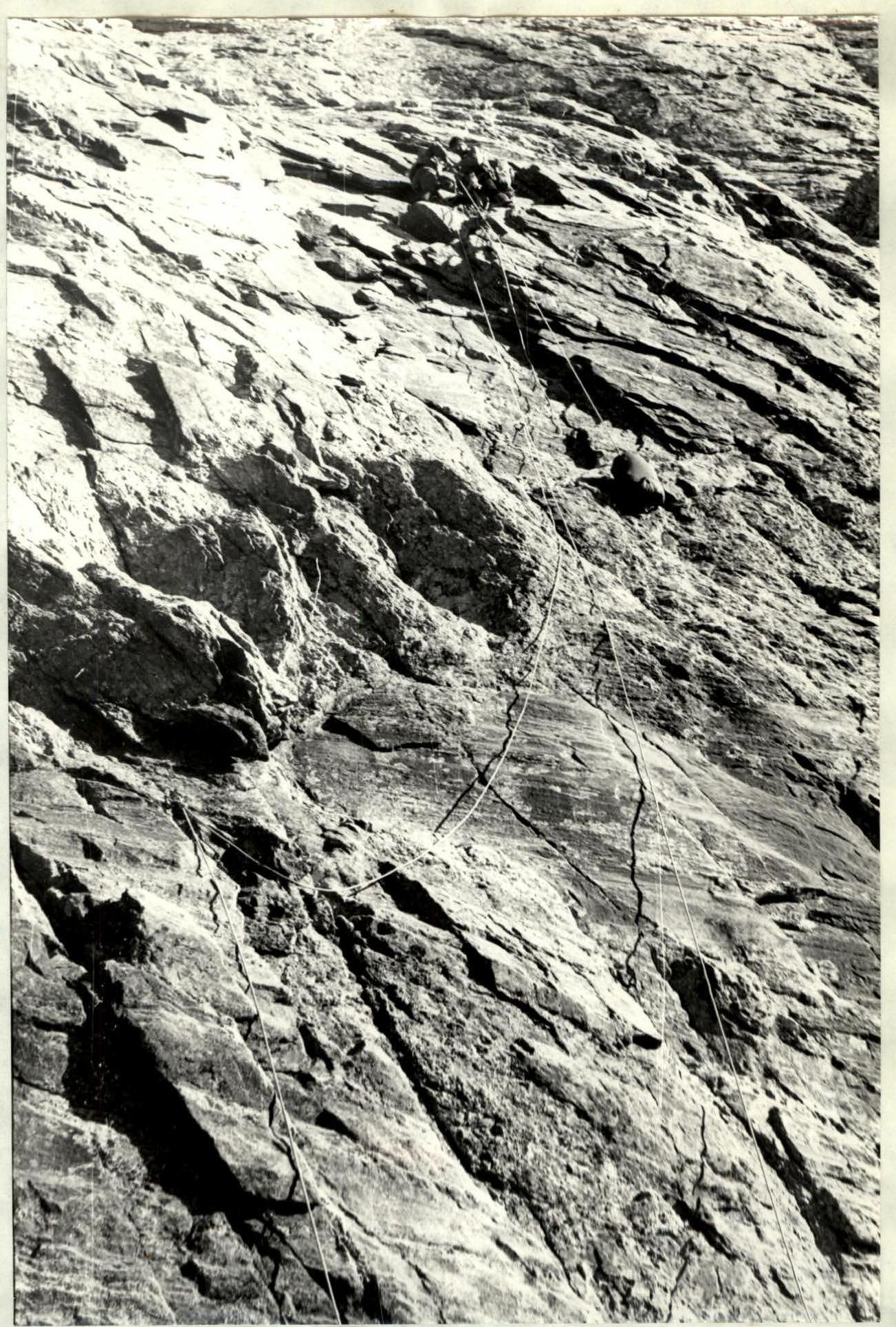
Pulling backpacks on section R18–R19.
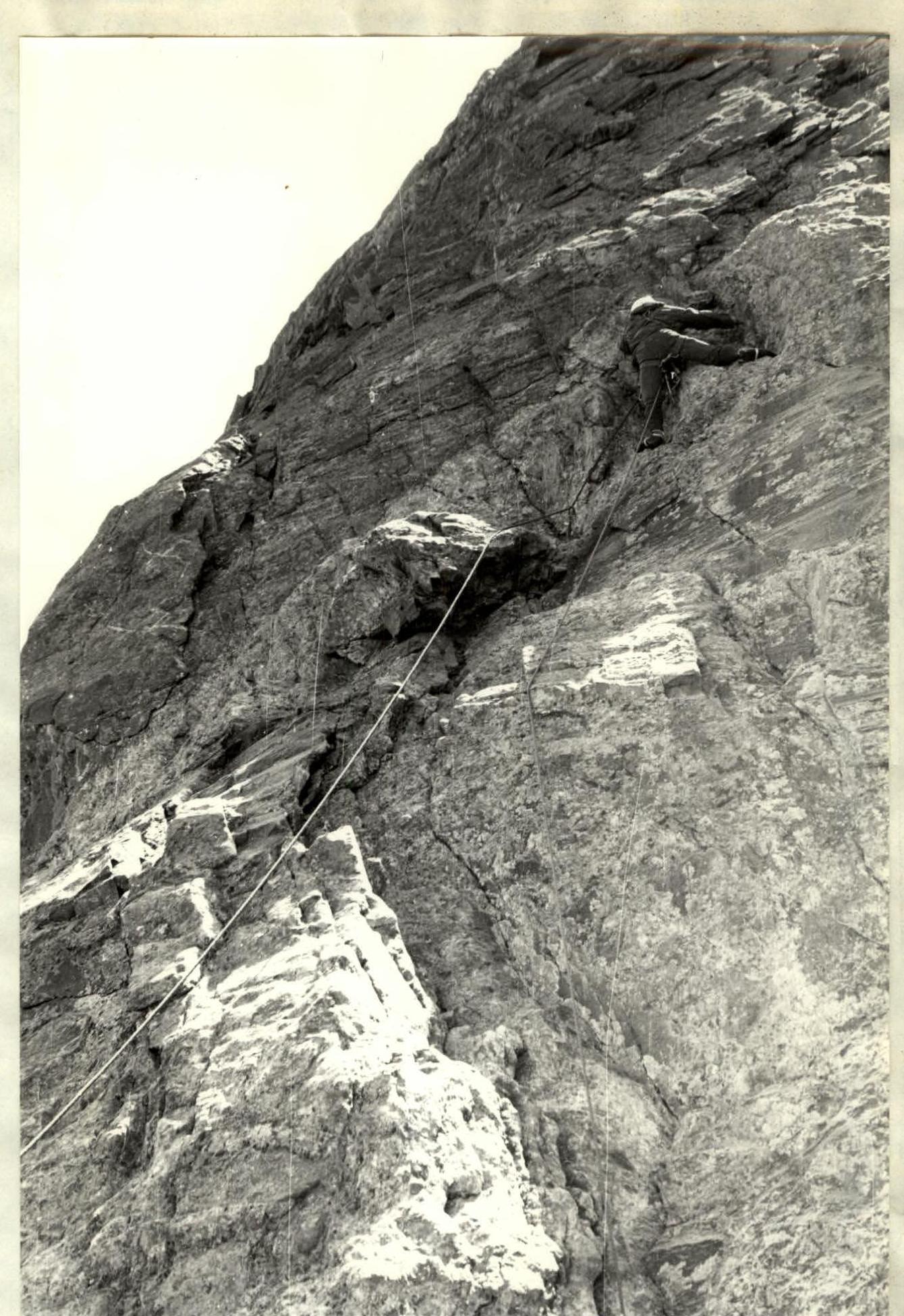
Section R28–R29 is overcome by CMS Vasilenko V.I.