Passport
-
Altitude-technical category
-
Eastern Pamir, Yazgulemsky Range
-
Peak Kholodnaya Stena via the East face (“silver route” by Salonnikov, at the USSR Championship 1980).
-
6B category of difficulty, second ascent
-
Height difference — 1710 m; length — 2080 m; length of sections with 5–6 category of difficulty — 760 m; average steepness of the main sections 76° (5000–5700 m), including 6 category of difficulty 88° (5300–5700 m).
-
Pitons hammered:
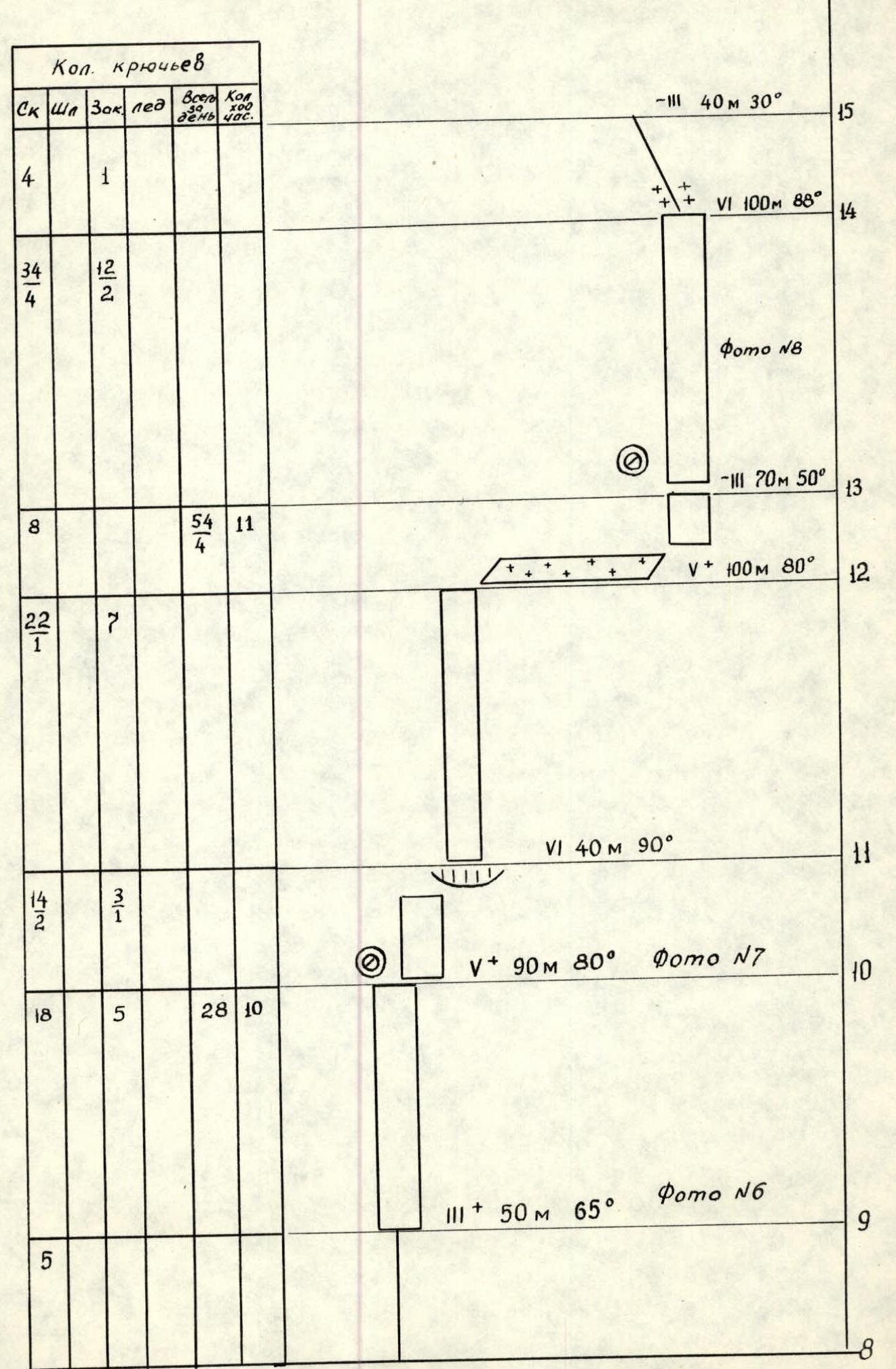
Category Total Per day Rock 309 17 Bolt 0 0 Chocks 88 7 Ice screws 66 3 -
Team's total climbing hours 73 and days 7.
-
Overnights: 1, 2, 4 and 5 — platform carved on a snow-ice cornice; 3 — sitting on a platform; 6 and 7 (7 — on descent) — on a snowy ridge.
-
Team leader: Igor V. Bozhko, Candidate Master of Sports
Aleksey A. Derkach, Master of Sports; Valery V. Kuzmuk, Candidate Master of Sports; Pavel S. Serenkov, Candidate Master of Sports; Oleg S. Tsakanyan, Candidate Master of Sports.
-
Coach — Aleksandr A. Verba, Master of Sports.
-
Approach to the route: August 6, 1983.
Summit — August 12, 1983. Return — August 13, 1983.
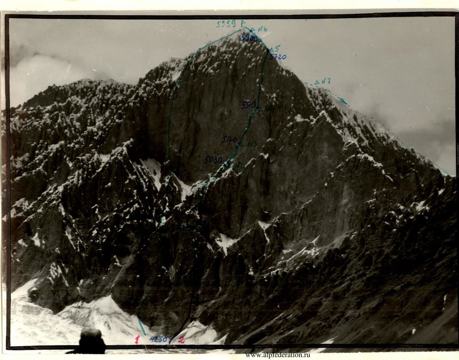
Photo #1. General photo of the summit.
1 — “Golden route” at the USSR Championship by Kovtun, 1980; 2 — route completed by the team (“silver” route at the USSR Championship by Salonnikov, 1980). Photo taken at 15:00, August 5, 1983, camera “Zenit V”, lens “Helios-44” 2/58. Distance to the object 2 km, shooting point on the area scheme #1, elevation 4100 m.
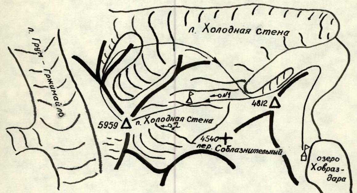
Scale map of the area around Peak Kholodnaya Stena
Scale 1:50000 — base camp — observation camp — photo shooting point. To approach the start of the route, the team left the base camp near Lake Hovraz-Dara on August 5 at 11:00. Around 16:00, the group set up a bivouac on the glacier, within 20 minutes' walk from the start of the route. At 17:00, the pair Bozhko — Derkach started route preparation. Bozhko worked first. By 21:00, having fixed 100 m of rope, the pair returned to the bivouac. The first 40 m of the route were the most challenging, representing an almost sheer, heavily deteriorated wall. Given the high risk of rockfall, the leader of the rope team and all sections of the route where ropes remained for an extended period were secured with double ropes (section R0–R17).
On August 6, after dismantling the bivouac, the team started the route at 6:30. The pair Kuzmuk — Serenkov led, fixing ropes. At 19:30, the team set up their first overnight stay on a snow-ice cornice (Photo #3), having fixed 120 m of ropes beforehand (section R2–R3). The first overnight stay was under a rock overhang, which provided protection from potential rockfall.
On August 7, starting at 8:30, the team reached their second overnight stay on a snow-ice cornice by 19:30, approximately 100 m from the start of the steepest part of the wall. The pair Serenkov — Tsakanyan led first. The most hazardous part of the day was navigating through the “mushrooms” (sections R5–R6, Photo #4 and R7–R8, Photo #5). Due to difficulties in organizing protection, the most rockfall-prone section R6–R8 was traversed after 16:00, when the wall was no longer exposed to sunlight.
At 7:30 on August 8, the team dismantled the bivouac and was at the base of the main wall about an hour later. The pair Derkach — Bozhko led. After ascending 50 m up the wall, a small, leveled platform under an overhang was found with signs of a previous team's presence (a gasoline can, fiberglass, etc.), where it was decided to set up the third overnight stay (Photo #7). Here, the lead in the rope team was changed (Bozhko went first). Having fixed 140 m of ropes by 18:00, the pair returned to overnight stay #3. Section R10–R11:
- is nearly vertical;
- is prone to rockfall;
- ends with a small overhang.
Throughout August 8, there was fog, snow, and sleet.
On August 9, starting at 9:00 (with the pair Tsakanyan — Serenkov leading), by 12:00, the group found a second platform, prepared by the preceding team on a cornice, where the fourth overnight stay was set up (point 13). Having processed 60 m of a sheer, smooth wall (section R13–R14, Photo #8), the pair descended to overnight stay #4 by 20:00.
On August 10, movement began at 7:00 (with the pair Bozhko — Derkach leading). Sections R13–R14, R15–R16 — very challenging, sheer rocks with overhanging sections. On the overhang of section R15–R16, a broken piton was found hammered; higher up (upper parts of sections R15–R16 and R16–R17), there were abandoned pieces of the main rope, and in some places, hammered pitons and other signs of the previous team (1980) were observed. Derkach executed the ascent up the ice wall onto the cornice on the North ridge of the peak. The fifth overnight stay was on this cornice (point 17, Photo #9, 21:00). Protection on the overnight stay was with ice screws and through an ice “ear”.
On August 11, from 9:00 to 18:00, the group moved along the snow-ice ridge, section R17–R18 (with Derkach — Bozhko leading), which was a jumble of cornices (Photo #10), very challenging due to difficulties in organizing protection (ice axe, ice screws) and objective danger from overhanging cornices, requiring significant time. The sixth overnight stay was on a fairly broad snowy ridge. Another 80 m of the ridge was processed.
On August 12 — bad weather (fog, snow, strong wind). Movement started at 9:00, section R18–R19. The pair Derkach — Bozhko led. The snow was very loose, requiring trenches to be dug. At 16:00 — on the summit.
At 16:30, descent began via the West ridge, category 3B difficulty (Photo #11). Overnight stay on the ridge (20:00).
On August 13, at 12:00, the group, having completed the ascent, descended in full.
The team's work on the route from August 5–11 followed the tactical plan. The reason for the unplanned seventh overnight stay on descent was the bad weather on August 12, which increased the danger from snowy overhangs, and the challenging snow conditions on the ridge, not accurately accounted for in the time calculation. This led to an increase in the time taken to traverse the ridge by several (~5) hours.
Throughout the ascent, communication was regular (at 8:00, 12:00, 16:00, 20:00) with the base camp through observers.


 Approach to the start of the route via steep snow. Section R0–R1 — a heavily deteriorated steep wall, followed by 40 m to the right and upwards along a weakly defined ledge to the eroded ridge of the counterfort. Along this ridge, 600 m to the summit of the counterfort (point 3). From the summit along the snowy ridge (section R3–R4) and 80 m up the wall (section R4–R5) — bypassing the “mushrooms” (section R5–R6) beneath them is an objectively hazardous area. Then, via an inner wet corner (85°) — 40 m under the wall (section R6–R7), leading to the next “mushrooms”, bypassed on the right via the wall (section R7–R8). From the “mushroom” to the right and upwards along the snow-ice ridge (section R8–R9) under the main wall, prone to rockfall. Moving along a weakly expressed inner corner, ascent to a platform (90 m). Here, a sitting overnight stay (point 10). Departure from the overnight stay to the right, 10 m traverse, and to the right and upwards to an overhang, using artificial aids (40 m). Here is a convenient spot for protection. Moving further to the right and upwards, crossing an inner corner (section R11–R12), exit onto a sloping ledge, at the end of which a platform for one tent is laid out. From the platform straight up, 100 m via a sheer wall (using artificial aids), crossing an inner corner (from left to right) (section R13–R14), exit onto a sloping ridge (section R14–R15), leading to a wall 110 m (section R15–R16) with a series of overhangs (using artificial aids). After the wall, move to the right and upwards towards a small gap on the summit ridge. Via a broad inner corner through overhanging sections (using artificial aids) and a wall (frozen in the upper part and turning into ice) — exit onto an ice “mushroom” (point 17), to the left of which is a 40 m ascent onto the North ridge and along it (400 m) — exit onto the summit (overhangs, difficulty in ensuring protection).
Note in a cairn 20 m west of the summit. Descent via the NW ridge (category 3B difficulty) 6–7 hours.
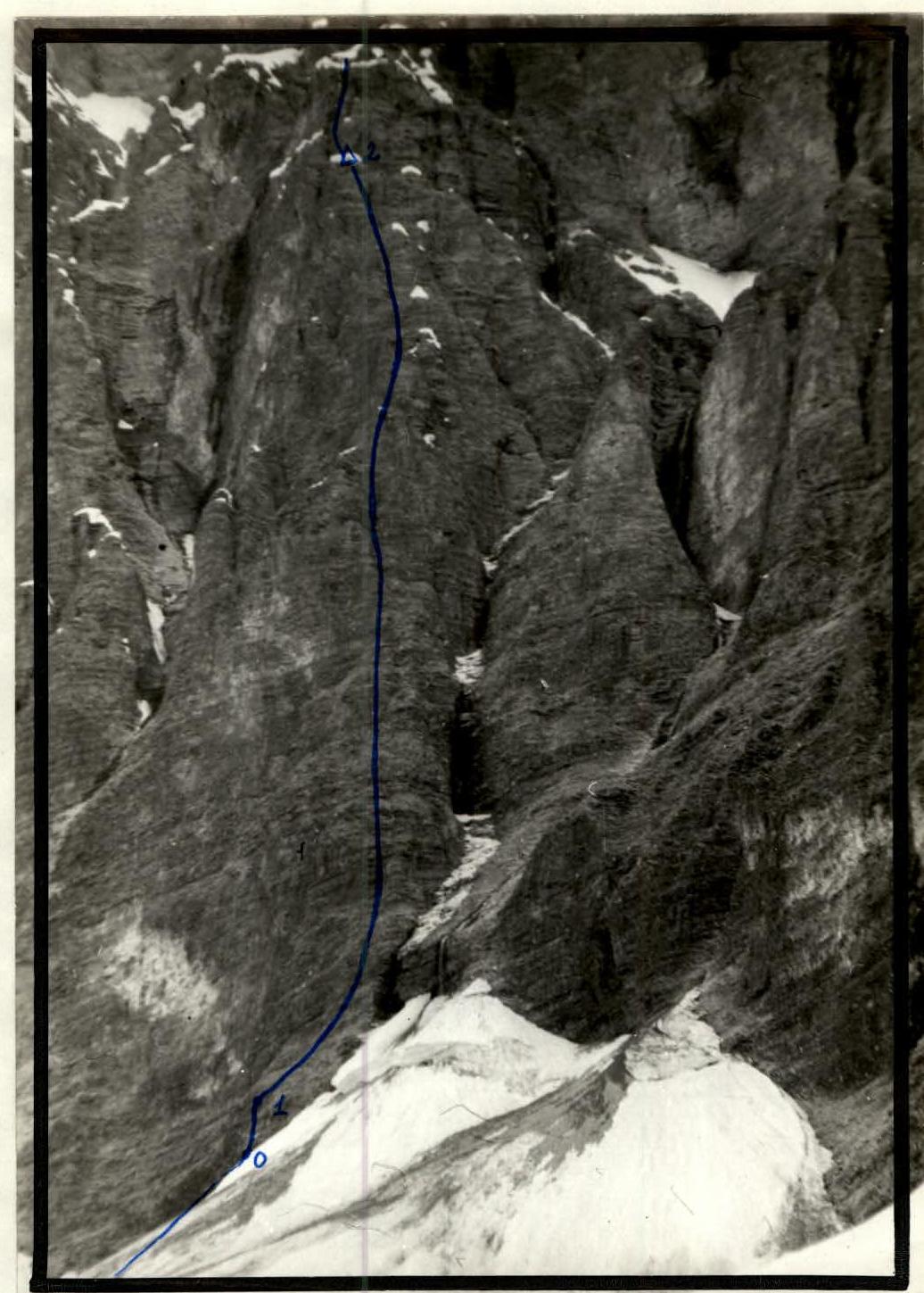
Photo #2. Lower part of the route (section R0–R2). Photo taken at 17:00 on August 5, 1983. “Zenit V”, “Helios-44”, 2/58. Distance to the object ~1 km, shooting point on the area scheme #2, elevation 4200 m.
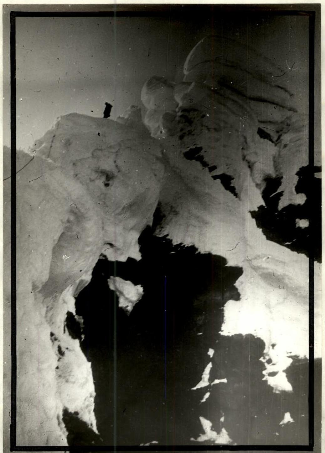
Photo #11. Characteristic view of the “mushrooms” on the summit ridge (section R17–R18). Photo taken at 14:00 on August 11, 1983. “Zenit V”, “Helios-44”, 2/58.

Photo #12. West ridge. Descent route. In the background, Lake Grum-Grzhimailo and Central Pamir. “Zenit V”, “Helios-44”, 2/58.
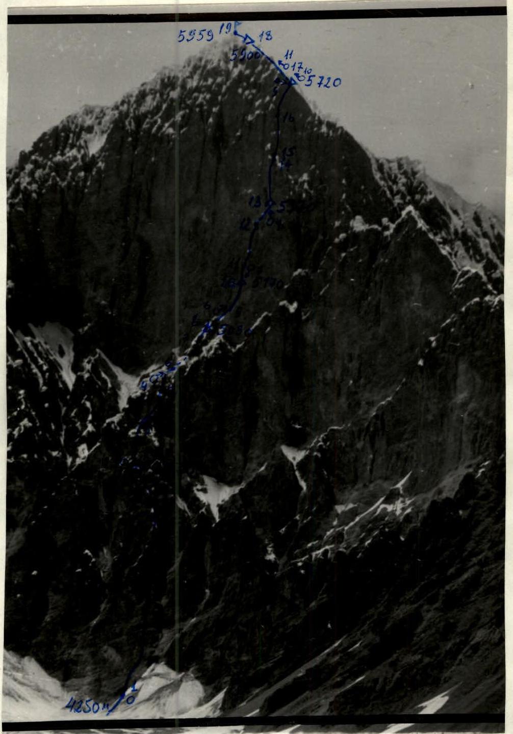
Photo #13. Technical photo of the route. Photo taken at 15:00 on August 5, 1983. “Zenit V”, “Helios-44”, 2/58. Distance to the object — 2 km, shooting point on the area scheme #1, elevation 4100 m.