Passport
- Class – altitude-technical.
- South-West Pamir, Shabo valley.
- Peak 5410 m via the western wall.
- Proposed – 5B cat. diff., first ascent.
- Height difference – 610 m, route length – 793 m.
Length of sections:
- II cat. diff. – 32 m,
- III – 165 m,
- IV – 135 m,
- V – 385 m,
- VI – 76 m.
Average steepness of the main part of the route – 71° (4810–5385), including:
- V cat. diff. – 85° (4940–4965),
- 90° (5305–5330),
- 92° (4935–4940, 5155–5160),
- 95° (5160–5175).
- Pitons hammered:
| rock | bolt | chocks | ice |
|---|---|---|---|
| 131/35 | - | 16/3 | - |
- Climbing hours – 30, days – 3.5.
- Overnight stays: 1st and 2nd – semi-reclining on a scree ledge (plus one semi-reclining on the descent, on a snow-ice slope).
- Leader – Vladislav Valentinovich Vedernikov, Master of Sport
Team members:
-
Alexander Anatolyevich Voronov, Candidate Master of Sport
-
Alexander Anisimovich Dubovikov, Candidate Master of Sport
-
Boris Konstantinovich Orlov, Master of Sport
-
Viktor Alexandrovich Solonnikov, International Master of Sport
-
Anatoly Magomedovich Tемиrov, Candidate Master of Sport
-
Coach – Viktor Alexandrovich Solonnikov, International Master of Sport.
-
Entry to the route – July 5, 1982 (July 5 – processing, July 6 – ascent). Summit – July 8, 1982, return – July 9, 1982.
-
Organization – Leningrad Regional Council of the "Trud" Sports Society.
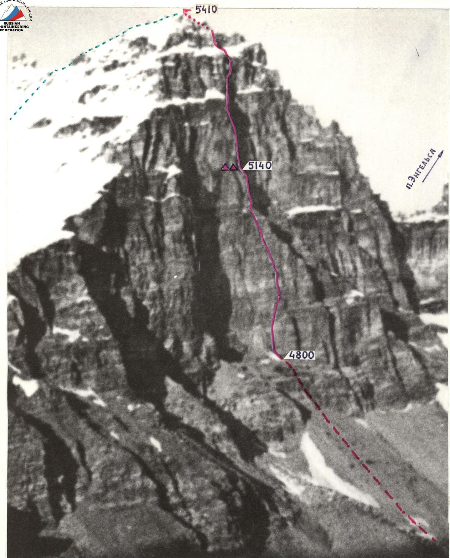
– overnight stays, altitudes – ascent route – descent path T-43 lens, focal length 4 cm. July 2, 1982. Distance to object 4 km, shooting point #I. Height of shooting point 4500 m.
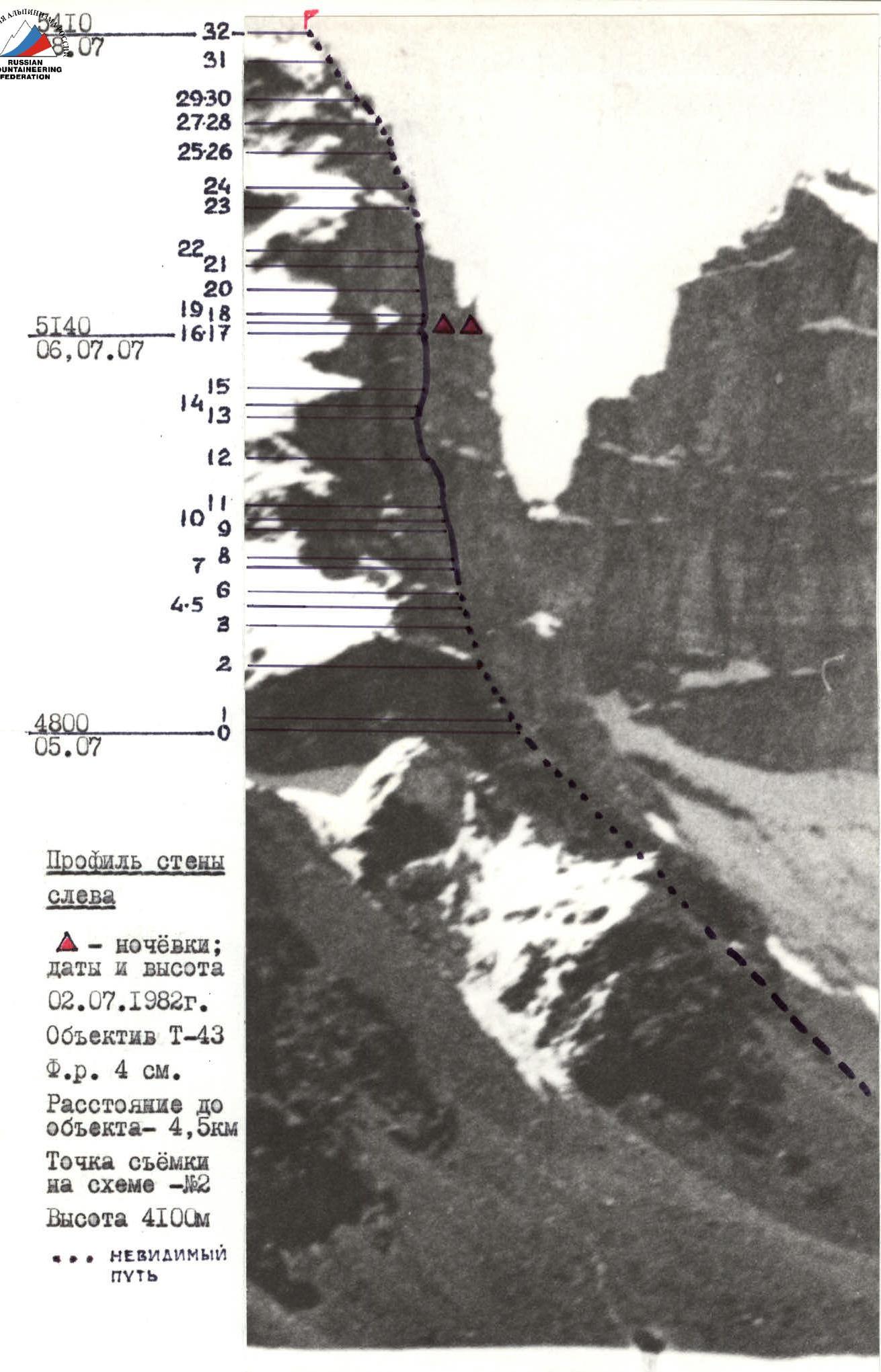
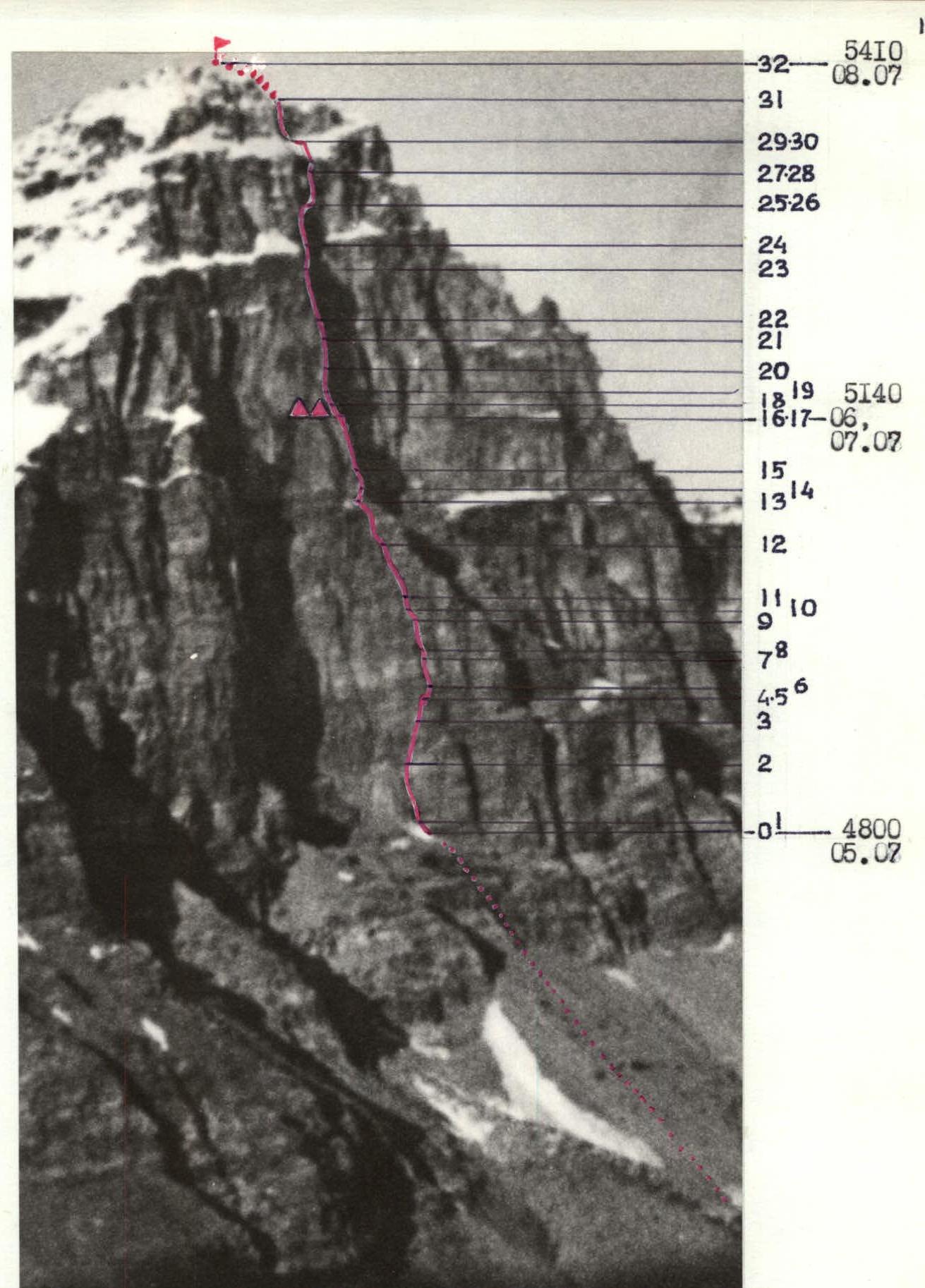
Profile of the wall on the left
- – overnight stays; dates and altitude July 2, 1982
T-43 lens, focal length 4 cm. Distance to object – 4.5 km. Shooting point on the diagram – #2. Height – 4100 m.

Route Profile
Scale 1:3000 (1 mm = 3 m)
Main part of the route – sections 1–31.
Map-Scheme of the Ascent Area
Scale 1:100000 (1 cm = 1 km)
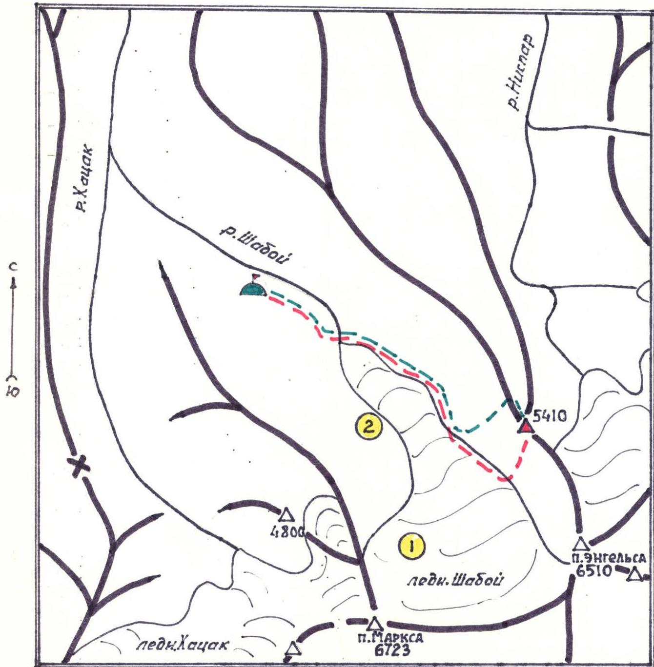
Conventional Symbols
- – approach path
- – base camp
- – descent path
- – observers' camp
- – shooting points
Tactical Actions of the Team
The team's actions on the route were determined by a pre-developed tactical plan, which was as follows:
- Day 1 — additional observation of the route and clarification of options. On the same day — processing of the lower part of the wall. Overnight stay directly under the route.
- Day 2 — as fast as possible passage of the first, simpler part of the route to a pre-planned overnight stay to create a time reserve in case of bad weather.
- Day 3 — processing with an overnight stay to the full length of the available ropes and further, depending on the weather and terrain features, movement to the summit or return to the previous overnight stay (on the second, more complex part of the route, suitable overnight stay locations were not visible).
The tactical plan was largely executed. The deviation from it was that due to extremely bad weather (strong wind and snowfall) and complex terrain (V+ – VI+), it was not possible to process the planned length of the section with an overnight stay. Movement on the route was organized as follows: the first climber worked mainly in galoshes, without a backpack. Double "Edelrid" rope satisfying UIAA requirements was used for belaying the first climber. Other participants moved using jumar ascenders along the ropes fixed to blocked pitons. The last climber moved with top-rope belay.
During the movement, participants:
- were able to approach the first rope,
- carried ropes and "hardware".
That is, the group moved at the speed of a two-person team. The first climber changed daily, but worked the whole day without a change from start to finish.
Schedule of the first climbers
| date | sections | type of movement | participant |
|---|---|---|---|
| July 5 | R0–R3 | processing | Dubovikov |
| July 6 | R3–R17 | movement without processing | Voronov |
| July 7 | R18–R19 | processing | Temirov |
| July 8 | R19–R32 | movement without processing | Vedernikov |
Overnight stay platforms in the middle of the route (semi-reclining) were cut into ice-cemented scree on a rock ledge, under the cover of an overhanging wall. Safety on the route was mainly ensured by proper organization of movement (sheltered gathering places, belays, and overnight stays, blocking of pitons, movement of participants within voice and visual contact, movement of the first climber on a double rope and the last – with top-rope belay), as well as the use of high-quality tested equipment. Radio communication sessions with observers were conducted according to the schedule. Radio station – "Lastochka" type. No notes, cairns, or signs of presence on the summit were found. No information about ascents to the summit is available. A cairn with a note about the team's ascent was built on the summit.
Route Diagram in Symbols
Scale 1:2000 (1 mm = 2 m) in height. Traverse sections (т) are also taken according to the height difference.
- 100 m of processed sections were passed in a day, and another 336 m to the overnight stay. Climbing hours – 13.
- 100 m were processed in a day, climbing hours – 4.
- For the entire route, total climbing hours – 30.
- 20 m of processed sections were passed in a day, and another 337 m to the summit. Climbing hours – 11.
- 20 m were processed in a day, climbing hours – 2.
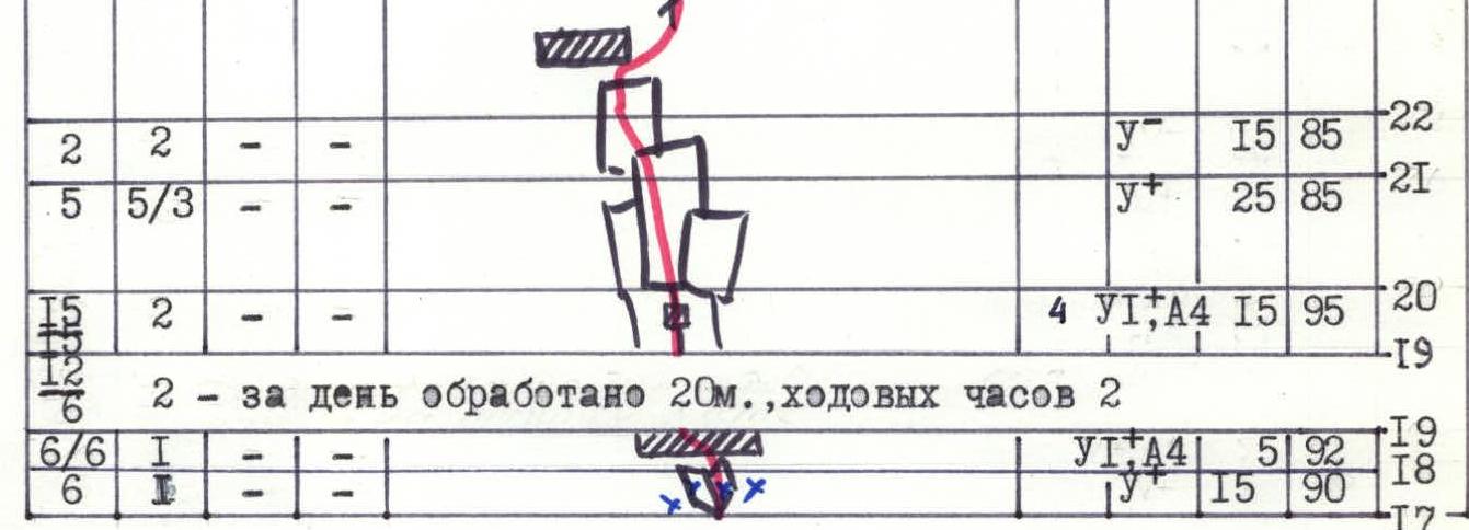
| rock pitons | chock pitons | bolt pitons | ice pitons | photo numbers | difficulty, cat. | section length, m | steepness, degrees | section numbers |
|---|---|---|---|---|---|---|---|---|
| - | - | - | - | 2 | II | 20 | 130 | R0 |
| 7 | 1 | - | - | - | V | 40 | 75 | R2 |
| 15 | 2 | - | - | - | IV | 40 | 60 | R3 |
| 1 | - | - | - | 1 | IV+ | 10т | 65 | R4–R5 |
| 2 | - | - | - | - | VI АТ | 10 | 65 | R6 |
| 5/2 | - | - | - | 1 | VI АТ | 25 | 80 | R7 |
| 2/1 | - | - | - | - | VI А4 | 6 | 92 | R8 |
| 3/2 | - | - | - | 2 | VI А4 | 25 | 85 | R9 |
| 1 | - | - | - | 2 | IV | 10 | 60 | R10 |
| 2 | - | - | - | - | IV+ | 10 | 60 | R11 |
| 5 | - | - | - | - | V+ | 60 | 45 | R12 |
| 6/2 | 1 | - | - | - | V А2 | 40 | 70 | R13 |
| 3 | - | - | - | 3 | V | 15 | 35 | R14 |
| 3 | - | - | - | 3 | V+ | 15 | 70 | R15 |
| 45/7 | - | - | - | 8 | III | 30т | 35 | R16–R17 |
| - | - | - | - | 1 | V | 15 | 90 | R17 |
| - | - | - | - | 6 | VI А4 | 5 | 92 | R18 |
| 6/6 | 1 | - | - | 6 | VI А4 | 5 | 92 | R19 |
| 4 | - | - | - | - | VI А4 | 15 | 95 | R20 |
| 5 | 5/3 | - | - | 2 | V+ | 25 | 85 | R21 |
| 2 | 2 | - | - | - | V | 15 | 85 | R22 |
| 7 | - | - | - | - | IV+ | 40 | 80 | R23 |
| 2 | 1 | - | - | 5 | V+ | 15 | 80 | R24 |
| 5/4 | 5/2 | - | - | - | V А3 | 10т | 70 | R25–R26 |
| - | - | - | - | 5 | V-А2 | 35 | 75 | R25–R26 |
| 4 | - | - | - | 2 | IV+ | 12 | 35 | R27–R28 |
| 4/1 | - | - | - | - | V | 90 | 70 | R27–R28 |
| 4 | - | - | - | - | IV | 25 | 60 | R29–R30 |
| 4 | - | - | - | - | V | 35 | 65 | R31 |
| 4 | - | - | - | - | III | 60 | 40 | R32 |

Description of the Route by Sections
The route begins to the left of the pronounced "sickle" offset in the center of the wall. R0–R1. Snow-ice slope. Belay through rock pitons. R1–R2. Steep monolithic slabs, a vaguely expressed internal corner to the left of the iced-up chimney of the "sickle" offset. Universal pitons, 4–6 mm. R2–R3. System of walls and slabs, rock and universal pitons 3–5 mm. R3–R4. Movement up and to the right along the slabs. Rocks are smoothed, few holds and places for hammering pitons. Thin pitons, 3–4 mm. R4–R5. Traverse along the slabs to the right, bypassing the cornice from below. Few cracks for pitons. R5–R6. System of small (2–3 m) walls. Free climbing, channel pitons 10–14 mm for belay. R6–R7. Steep two-colored (grey on the right, red on the left) internal corner. Few holds, holds are fragile. Thin and petal-shaped pitons. Use of artificial aids (ITO). At the end of the corner, a control cairn on a hook. R7–R8. Cornice overcome by tense free climbing. At the beginning of the cornice – a piton for a ladder. Unreliable yellow rocks. R8–R9. Steep internal corner, few holds and places for hammering pitons. Extremely tense climbing, movement in opposition. Petal-shaped pitons. Use of ITO. R9–R10. Blocky rocks of medium difficulty. Large channel pitons with loops. R10–R11. Congestion of ice-filled rock boulders. Universal pitons 4–6 mm. R11–R12. Heavily dissected rocks, systems of walls and ledges. Strong, reliable holds. Universal and channel pitons. R12–R13. Cornice overcome by free climbing and further – up and to the right along the smoothed internal corner with a crack. Use of ITO. Channel pitons with loops, chocks. R13–R14. Movement to the right along an ice-filled inclined ledge. R14–R15. Grey striped slab covered with a thin layer of ice. Few cracks for pitons, cracks are poor. R15–R16. Large-block dark grey striped rocks. Universal pitons, thin channel pitons with loops. R16–R17. Traverse to the right along a ledge with coarse scree lying on ice. Many loose stones. Belay through rock pitons. Overnight stay on the ledge. R17–R18. Iced-up internal corner formed by two huge rock blocks. Approach under the cornice. R18–R19. Cornice passed on ladders. All pitons – for creating ITO. Cracks filled with ice. Universal pitons 5–6 mm and channel pitons with loops. Exit to a small ledge. R19–R20. Yellow monolithic overhanging wall with cracks. Movement exclusively with the use of ITO, on ladders. Due to the frequent placement of pitons, descent down to hammer in lower pitons. Universal pitons 5–6 mm and thin channel pitons, stoppers 10–15 mm. Control note on a piton. R20–R21. Yellow, steep, smoothed, iced-up slabs. Few holds. Thin channel pitons. Active use of chocks – stoppers 10–15 mm, including for creating ITO. R21–R22. Monolithic grey wall. Few places for hammering pitons. Petal-shaped pitons. R22–R23. Movement by free climbing up and to the left along grey-yellow rocks under the red cornice, bypassing the cornice on the right along a dark-brown slab with a crack. Rocks are unreliable, it's hard to find a reliable place for hammering pitons. Universal pitons 5–6 mm. R23–R24. Monolithic grey striped rocks, steep internal corner with a crack. Few holds. Channel pitons 15–20 mm with loops. R24–R25. Steep smoothed slab with a crack. Use of ITO, pendulum. Approach up and to the right under the overhanging rock " утёс". Universal pitons 5–6 mm, channel pitons 10 mm. R25–R26. Traverse under " утёсом" to the right around the corner. Movement exclusively with the help of ITO, on "ladders". Hard to find places for pitons. Belay – sitting in a harness. Section is complicated for passage even on hung perches, especially for the last climber. Universal pitons 3–4 mm. R26–R27. Vertical chimney. Few holds, places for hammering pitons. Tense free climbing. Belay, sitting in a harness. Blocking of pitons. Universal pitons 3 mm, petal-shaped pitons. Exit to an ice-filled ledge. R27–R28. Traverse to the right along the ice-filled ledge to a vaguely expressed internal corner directed up and to the left. R28–R29. Steep inclined internal corner filled with ice, with an overhanging stone at the end of the corner. When passing participants, they are thrown out of the corner. Cracks filled with ice. Section is complicated for passage not only for the first climber but also for all other participants. Universal pitons 5–6 mm. R29–R30. Traverse to the left along a snow-ice slope with rock outcrops. Belay through rock pitons. R30–R31. Rocks filled with ice like "barany lby". Few places for hammering pitons. Movement with cleaning holds from ice. R31–R32. Firm firn slope. Movement with belay through an ice axe hammered into the slope.
Descent – along the north-west ice-snow slope.
Technical Photography of the Route
– overnight stays; date, altitude:
- July 2, 1982
- altitude 4500 m
T-43 lens, focal length 4 cm. Distance to object – 4 km. Shooting point on the diagram – #I. Height of shooting point – 4500 m.
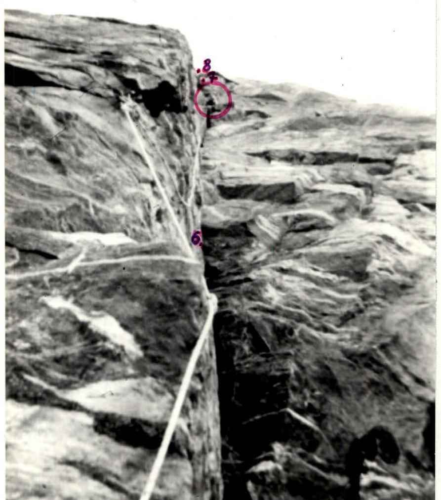
Photo #1. Sections R6–R8. Internal two-colored corner.
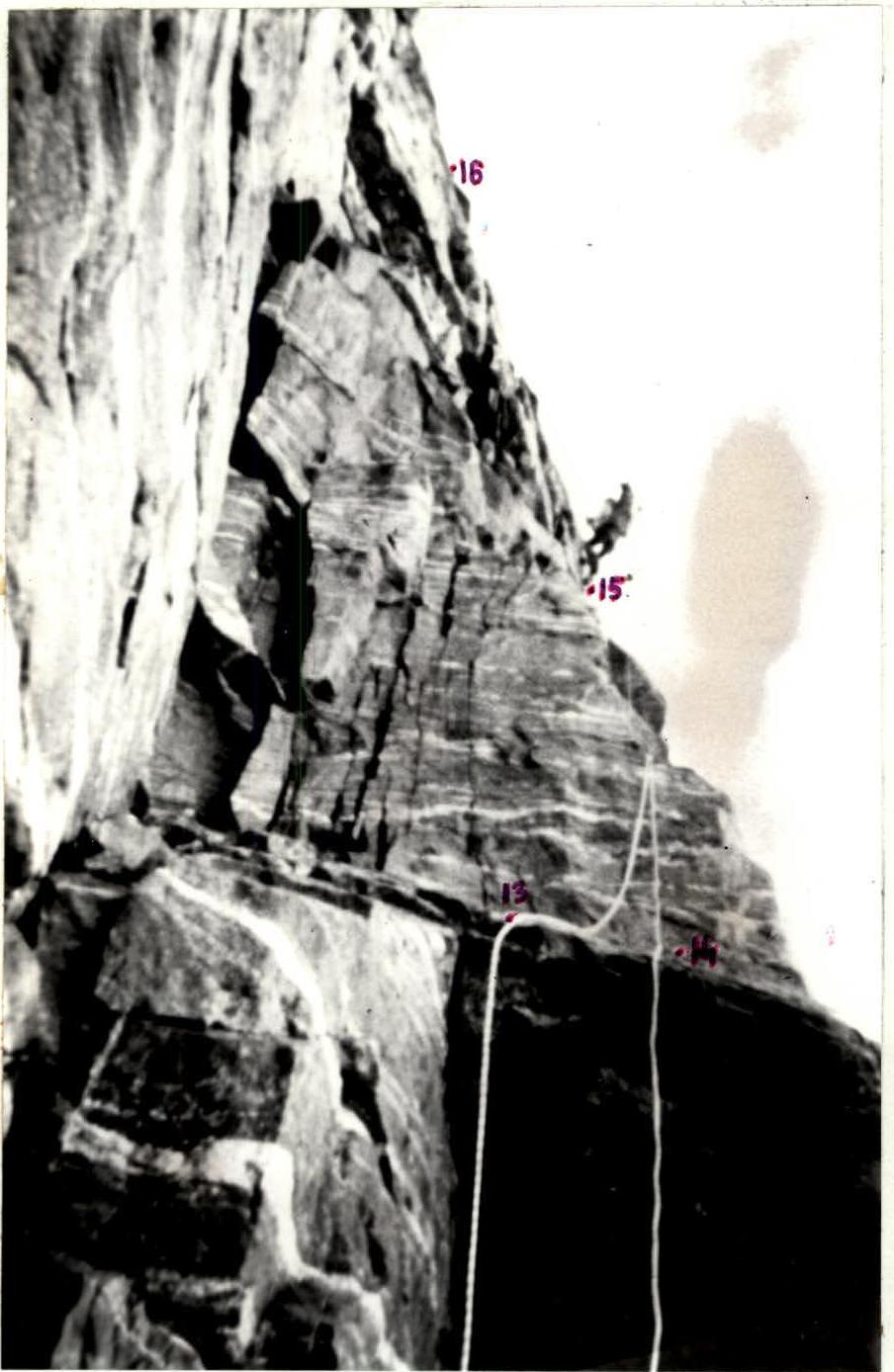
Photo #3. Sections R13–R16. Approach to the overnight stay along fixed ropes.
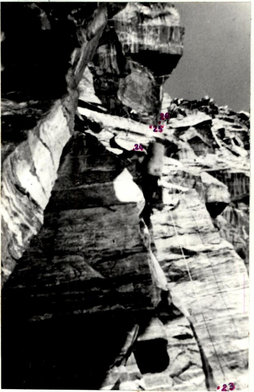
Photo #5. Sections R23–R26. Approach under the rock "Utyug".