Route: via the North-Eastern slope
Group of the Kharkov Regional Council of the "Avangard" Sports Society:
-
- Eremenko Grigoriy Nikolayevich, 2nd category
-
- Slobodyanik Lyudmila Ivanovna, 2nd category
-
- Sidorenko Nikolay Nikolayevich, 2nd category
The ascent was made between June 16 and 18, 1974.
1974, Kharkov ("Avangard")
Brief Geographical Description of the Ascent Area
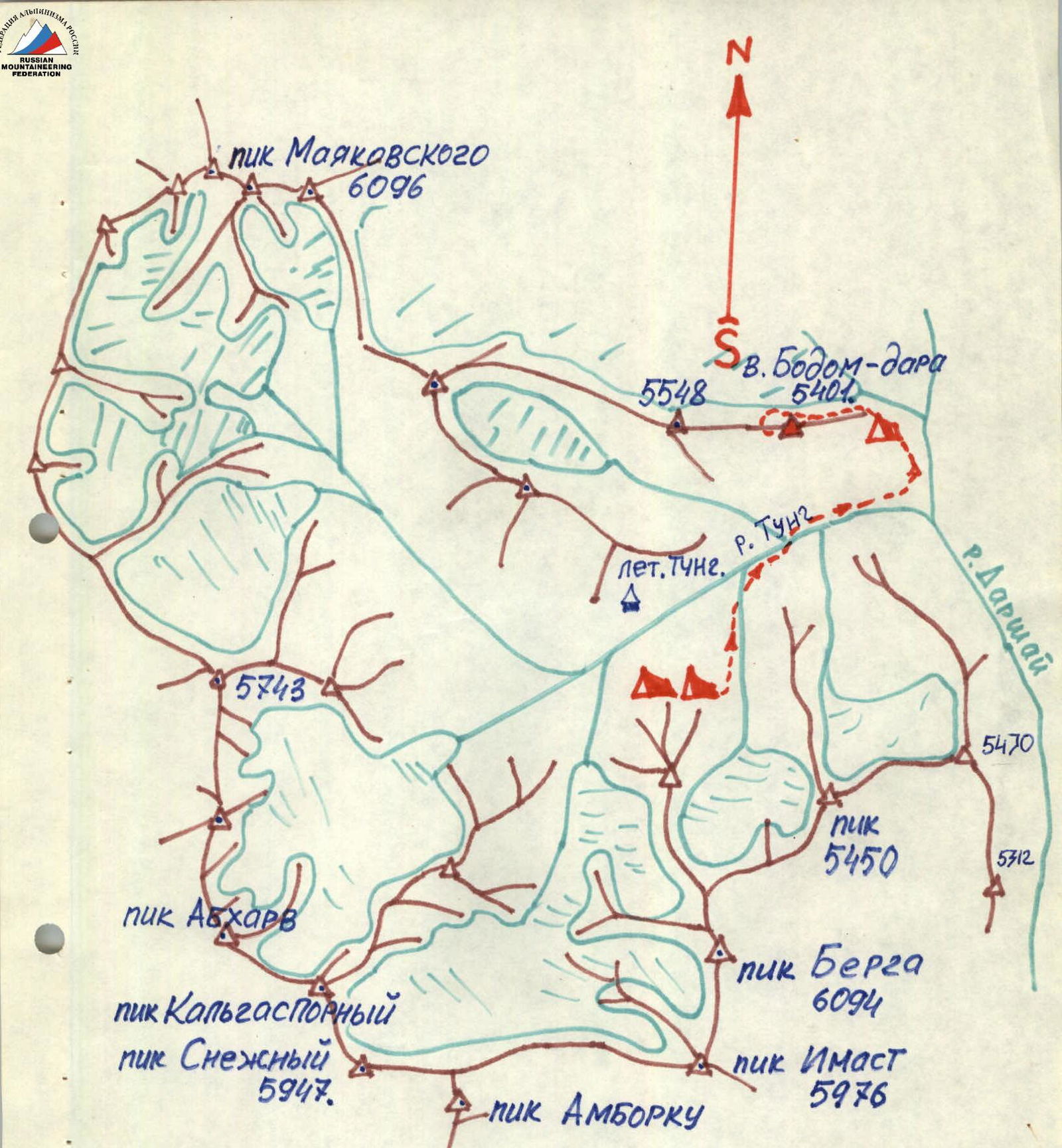
The expedition of the Kharkov Regional Council of the "Avangard" Sports Society worked in the South-Western Pamir in the area of Peak Mayakovsky in the upper reaches of the Darshai River. The Darshai River flows into the Pyandzh River 40 km upstream from the town of Ishkashim (district center). At the confluence of the Darshai and Pyandzh rivers lies the kishlak Darshai, 10 km from the Shikhtavr settlement council. There is a store in Darshai where food can be purchased. Shikhtavr has a larger store, a settlement council, post office, collective farm administration, club, and school. The Darshai River originates in the area of Peak Mayakovsky, approximately 50 km from the Pyandzh River along the Darshai gorge. There are summer pastures (yailaks) in the gorge, each about a 2-hour walk apart. The highest yailak, "Tung", is located near the tongues of glaciers descending from the peaks of:
- Mayakovsky,
- Berg,
- Abkharv.
Above the yailak, there are convenient terraces for helicopter landing and setting up base camps. This is where the 1947 expedition's base camp was located, and it was also used by the Kharkov Regional Council of the "Avangard" Sports Society's expedition.
Brief Description of Climbing Conditions in the Area
Climbers rarely visit this area. The first mountaineering expedition worked here in 1947. The expedition's report is described in the book by Zatumovsky, "Among Rocks and Snows." This expedition made several first ascents to the highest peaks in the area via routes up to category 3B difficulty:
- Peak Mayakovsky, category 3A
- Peak Berg, category 3B
- Peak Imast, category 3B
- Peaks Snezhnый, Kalgasporny, Tsentralny, category 2A
This year (1974), groups from the Kharkov expedition repeated some of these routes and removed the notes left by the 1947 pioneers. They also made four new first ascents to unnamed peaks:
- 5470 m
- 5450 m
- 5461 m
- 5200 m
The "unpopularity" of this area can be attributed to its inaccessibility compared to the areas around Peaks Marx and Engels: it requires either a helicopter or a three-day journey with a caravan of donkeys from the Darshai kishlak. The Kharkov expedition used a Mi-8 helicopter for transportation. The base camp was set up near the "Tung" yailak. It is worth noting that the area has numerous peaks between 5300–5700 m that could interest climbers of various skill levels, offering a range of routes from category 1B to 6B.
Characteristics of the Object
The Badom-Dara peak is located in a mountain ridge extending from Peak Mayakovsky in a south-easterly direction. The peak is visible from the Darshai gorge (Fig. 1). A tower-like gendarme and a triangular rock formation, often mistaken for the peak from a distance, are prominent features. The actual peak is located to the north-west and is snow-covered.
The slopes of the peak can be either purely rocky or snowy, depending on the time of year. By the end of June, the slopes are a mix of snow and rock. The rocks are fragile, with many cracks and loose stones.
South-Western Pamir. (Upper reaches of the Darshai River).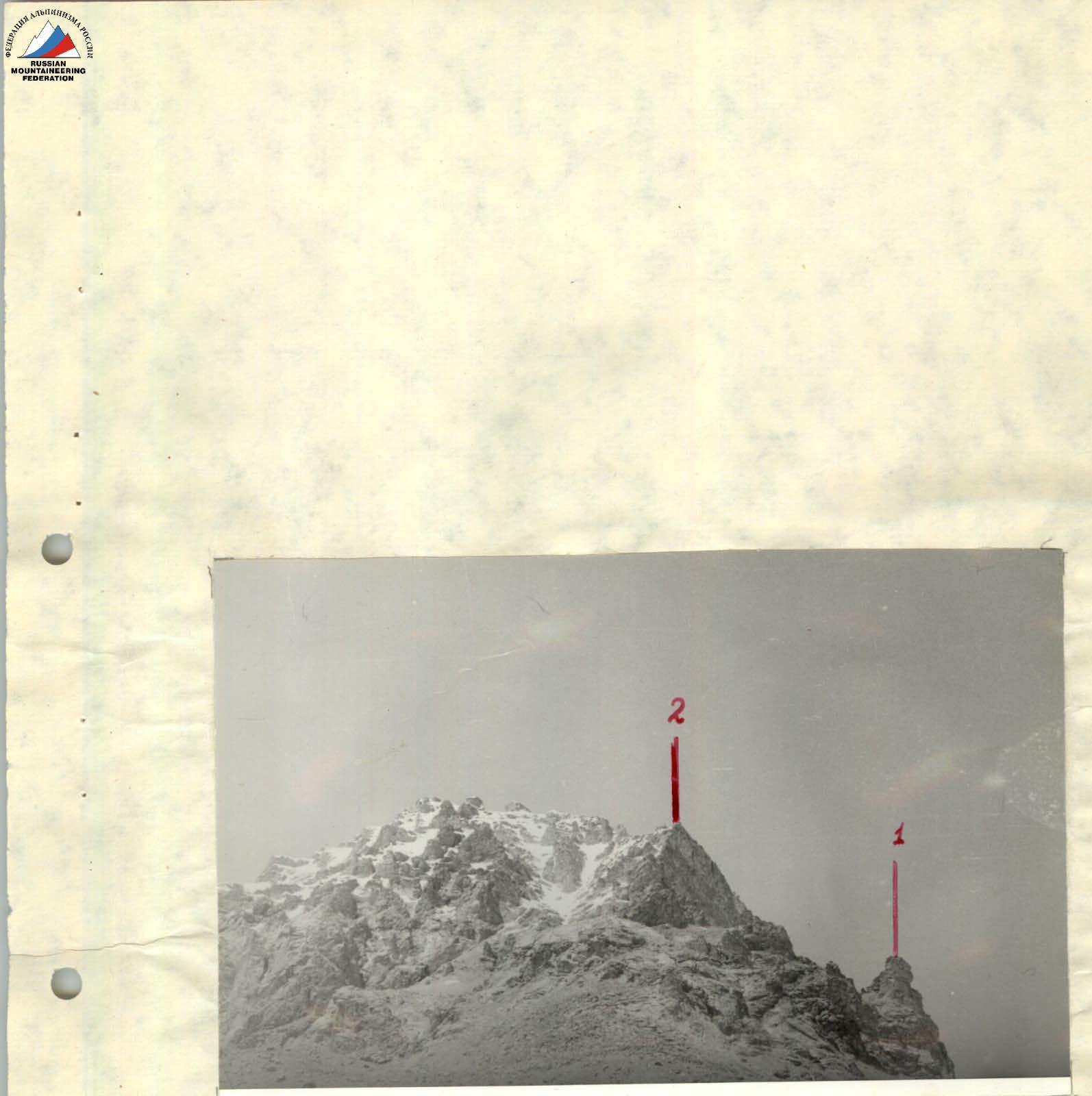
Fig. 1. View of the peak from the entrance to the gorge.
- I — tower-like gendarme
- 2 — triangular wall
Description of the Route by Days
Day 1
From the base camp, cross the Tung River and move downstream along the left bank until the Tung gorge turns south towards the Darshai gorge. From this turn, move upstream along the Darshai River towards the Badom-Dara peak, which is visible from the gorge. A prominent gendarme serves as a landmark. Set up camp at the foot of the peak, near a lake, where conditions are favorable. The journey from the base camp takes 4–5 hours.
Day 2
Depart from the bivouac at 5:00. After an hour's walk, reach a scree slope that needs to be traversed to the right of a gendarme, ascending 100–120 m (R1).
Reach a wall between two gendarmes. The wall is 30–40 m high, with an approximate incline of 70°; piton belay is used. At the top of the wall, there's a control cairn (R2).
Continue up a scree slope with a 40–45° incline, category 1 difficulty, for 100–120 m until reaching snow-covered inclined slabs at the base of the triangular wall (R3).
Traverse the snow-covered slabs to the right and upwards for 120 m, with a 40–45° incline, category 2 difficulty, to reach under the wall (R4).
Ascend the wall for 60–70 m, with a 75–80° incline, category 5 difficulty, to reach a snowy slope under an overhanging rock (R5).
Move up a challenging slope with a 30–40° incline to the right towards a visible gap — 60–80 m; then through the gap, 7–10 m of wet rocks (overcome by climbing), to reach a snow-ice couloir (R6).
Continue up the couloir with a 40–45° incline, 250–300 m long, category 3 difficulty (R7). There's a suitable spot for camping in the lower part of the couloir.
The couloir is closed by a wall. On the left side of the wall, there's a chimney 25 m long, category 4 difficulty. The chimney leads to a sharp ridge 40 m long, category 3 difficulty, which goes to the right towards a gendarme. The gendarme is bypassed on the left via a couloir 30–40 m long, category 3 difficulty. The couloir leads to the next ridge (R8). There's a control cairn on the saddle.
The path continues along a snow-covered ridge. After 60 m, there's a rock wall; 6–8 m of vertical rocks are overcome directly (R9).
Continue along the snowy ridge with a 30–40° incline.
Two rocky, tower-like gendarmes are bypassed on the left via rocky ledges with piton belay (R10). Under the second gendarme, there's a convenient spot for camping.
The group stopped for the night at 16:00.
Day 3
Depart from the bivouac at 7:00. Move along a snowy slope towards the third gendarme, 100–150 m, with a 50° incline (R11). The gendarme is overcome on the left via a 40 m wall, category 4 difficulty (R12). Reach a ridge leading to the peak. Continue along the ridge, category 3 difficulty, to the summit (R13). Reach the summit at 12:00.
The descent was made via a snowy couloir on the southern slope with a 35–40° incline. The descent was complicated by 5–6 steep, wet rock faces (65–70°) resembling "ram's foreheads," 10–30 m high. These were overcome by rappelling or down-climbing. Return to the bivouac at 16:00.
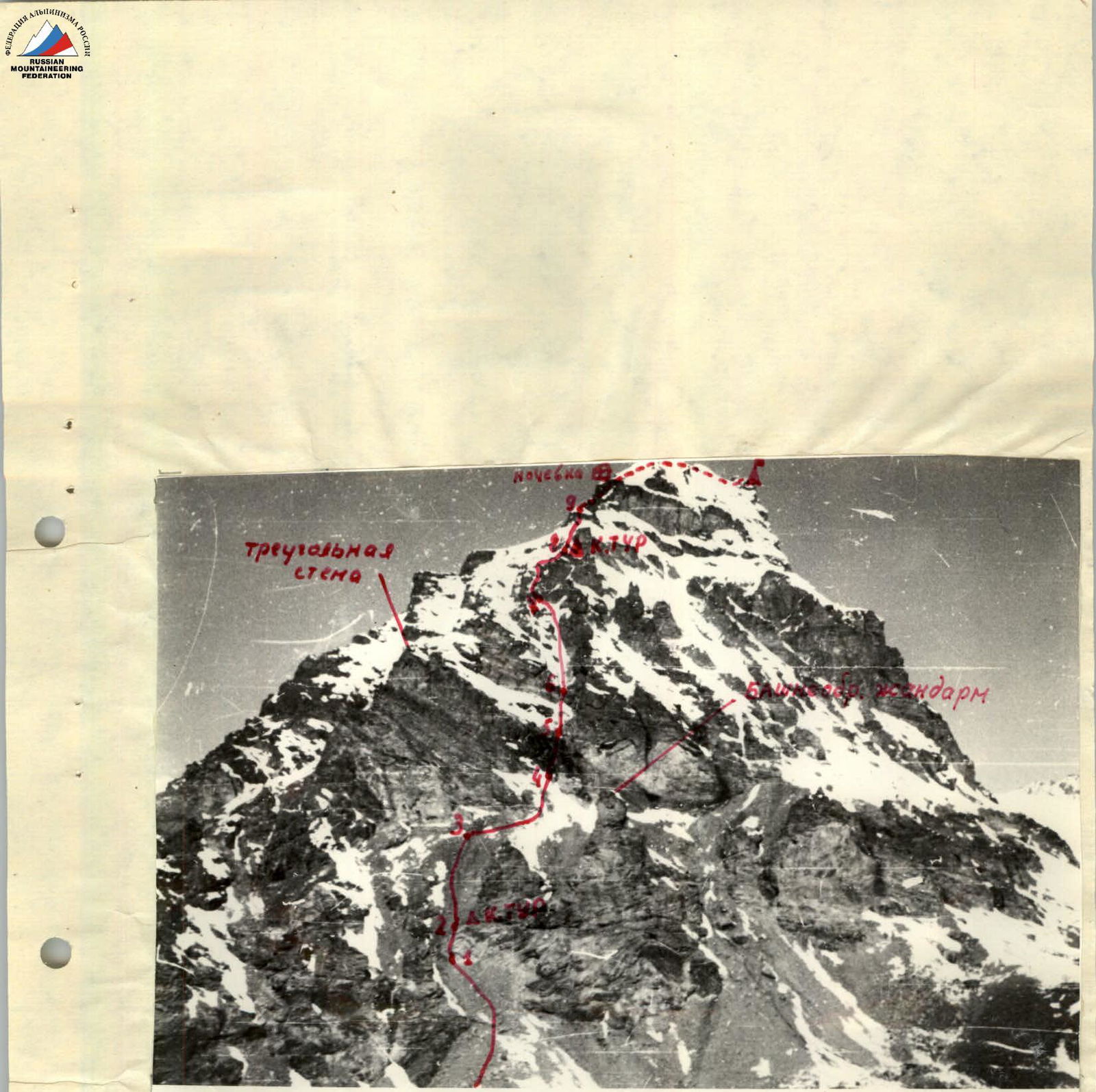
Fig. 2. South-eastern slope of Badom-Dara peak.
- visible section of the route
- invisible section of the route
- Badom-Dara peak
- overnight stop on the route
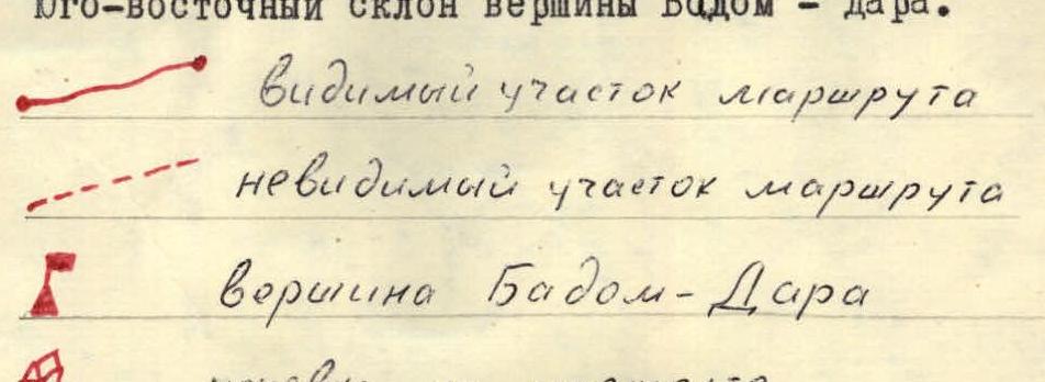 Table of main route indicators
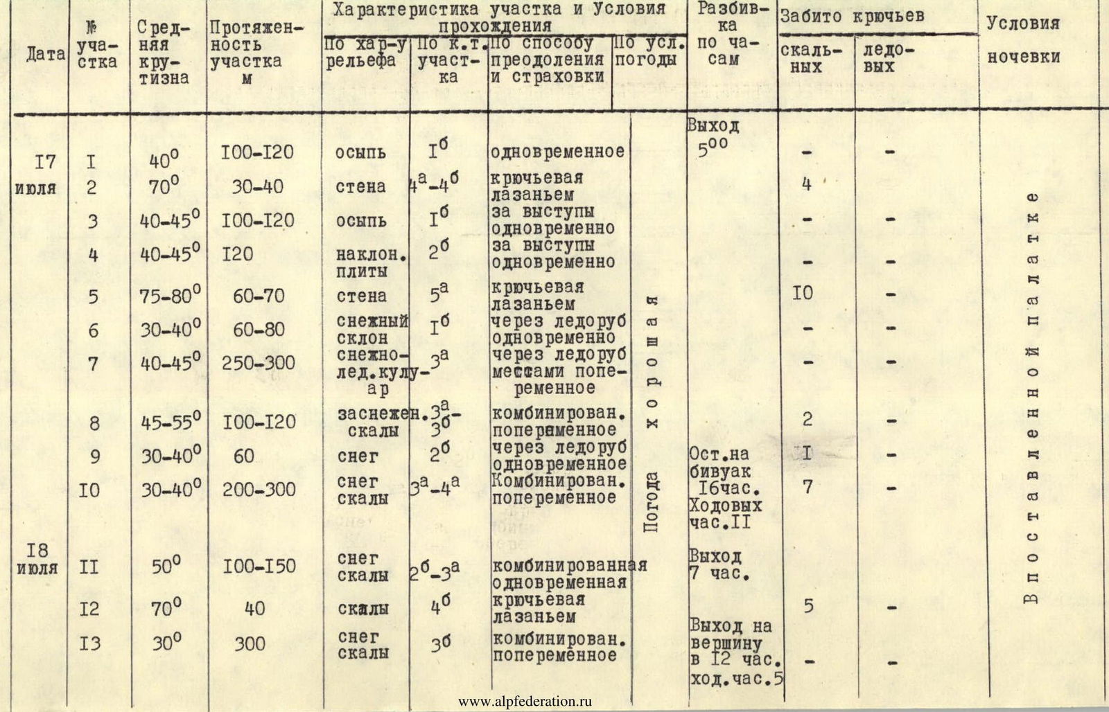
| Date | Section № | Average Steepness | Section Length, m | Terrain Characteristics | Difficulty Category | Method of Overcoming and Belay | Weather Conditions | Time Breakdown | Pitons Driven, Rock | Pitons Driven, Ice | Camping Conditions |
|---|---|---|---|---|---|---|---|---|---|---|---|
| July 17 | R1 | 40° | 100–120 | scree | 1 | simultaneous | good | Departure 5:00 | – | – | In a pitched tent |
| R2 | 70° | 30–40 | wall | 4 | piton belay, climbing | good | – | 4 | – | In a pitched tent | |
| R3 | 40–45° | 100–120 | scree | 1 | on outcrops, simultaneous | good | – | – | – | In a pitched tent | |
| R4 | 40–45° | 120 | inclined slabs | 2 | on outcrops, simultaneous | good | – | – | – | In a pitched tent | |
| R5 | 75–80° | 60–70 | wall | 5 | piton belay, climbing | good | – | 10 | – | In a pitched tent | |
| R6 | 30–40° | 60–80 | snowy slope | 1 | via ice axe, simultaneous | good | – | – | – | In a pitched tent | |
| R7 | 40–45° | 250–300 | snow-ice couloir | 3 | via ice axe, partially alternating | good | – | – | – | In a pitched tent | |
| R8 | 45–55° | 100–120 | snow-covered rocks | 3 | combined, alternating | good | – | 2 | – | In a pitched tent | |
| R9 | 30–40° | 60 | snow | 2 | via ice axe, simultaneous | good | – | 1 | – | In a pitched tent | |
| R10 | 30–40° | 200–300 | snow, rocks | 3–4 | combined, alternating | good | Stop at bivouac 16:00. 11 hours walking | 7 | – | In a pitched tent | |
| July 18 | R11 | 50° | 100–150 | snow, rocks | 2–3 | combined, simultaneous | good | Departure 7:00 | – | – | In a pitched tent |
| R12 | 70° | 40 | rocks | 4 | piton belay, climbing | good | – | 5 | – | In a pitched tent | |
| R13 | 30° | 300 | snow, rocks | 3 | combined, alternating | good | Reach summit at 12:00. 5 hours walking | – | – | In a pitched tent |
Route Recommendations
- Group size: 4–6 people.
- Sections R1–R4 should be traversed early in the morning due to the risk of rockfall.
- Sections R10–R13 should be traversed early in the morning when the snow is firmer and easier to navigate.
- Be cautious of loose rocks when passing rocky sections.
- Descend to the overnight stop on the ascent route, then exit onto the southern slope with a 40° incline and descend to the base of the peak along the southern slope.
Route Assessment
Based on the experience of previous ascents, this route is assessed as category 4B difficulty.