24a
REPORT
on the first ascent of Surkhu peak via the western wall (approximately 6th category of difficulty), made by the SKA MVO team during the Moscow championship in the technical class
Geographical Characteristics of the Ascent Object
The ascent area is the Darang-Rawang river gorge. The Rawang gorge descends from the Vanch ridge into the Vanch river valley. The gorge is completely unexplored in terms of alpinism, and no ascents have been made there before. The weather conditions are good.
On both sides of the Rawang river, where it flows into the Vanch river, there are settlements:
- Garmuchina
- Ravand
The approach to the ascent area is good, with a well-maintained road. The Surkhu peak is clearly visible from the Garmuchina settlement.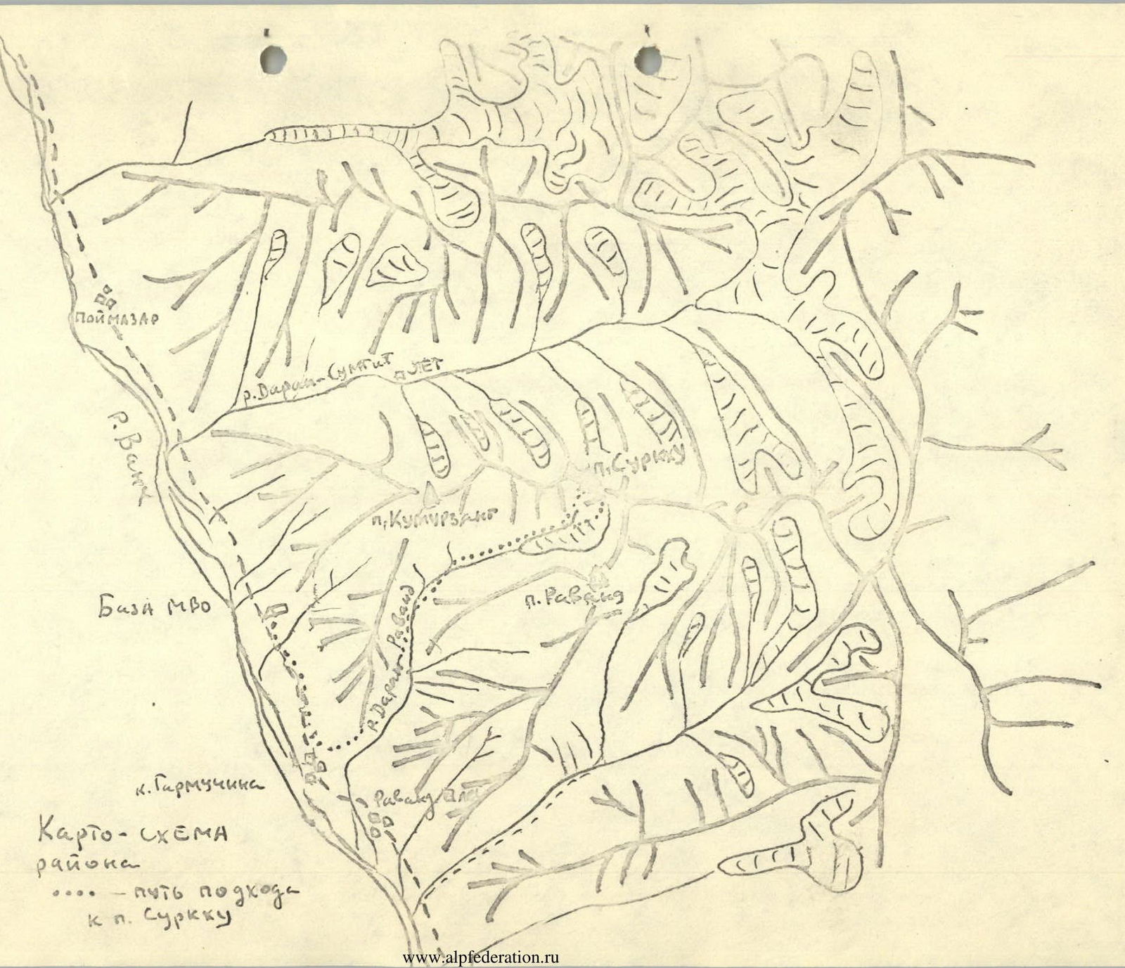
Tactical Ascent Plan
The Surkhu peak caught our attention while passing by the Garmuchina settlement in the Vanch gorge. We didn't know the name of the peak or the approach routes to it. Inquiries with local residents helped us determine that the name was Surkhu, meaning "red mountain," due to its composition of reddish-colored minerals.
The Surkhu wall has a western exposure. Initial reconnaissance revealed that the approach to the wall is not straightforward, as the gorge is narrow and canyon-like.
The group that made the first ascent of Komurzang peak observed Surkhu and examined possible approach routes to the peak. Additionally, a special reconnaissance was conducted by Yefremov and Vitsev to investigate the approach paths to the peak. This reconnaissance and consultations with the Komurzang group allowed us to outline a preliminary route up the western wall.
The wall is divided by a couloir-ridge at its center. To the left of it, the wall is vertical and monolithic in its lower part. Above it, there are:
- snow patches
- small snowfields
The rocks are heavily fractured, and the wall is exposed to falling stones.
A route to the right of the couloir seemed safe, interesting, and quite challenging. Preliminary reconnaissance allowed us to:
- roughly outline the route
- assess potential campsites
- determine the necessary equipment for the ascent
- estimate the required number of days, etc.
The final decision on the ascent route was made directly under the route. It was clear that the route would be very serious and demand significant effort and utmost attention and caution from us. Since the approach path was not entirely clear, we decided to set out during the day to get as close as possible to the peak and observe the planned route the next day to finalize the ascent path.
Upon closer inspection, the wall made an even greater impression. The entire middle part (above the break) is sheer, with many cornices, especially at the exit. The extent of this section is significant. The exit to the shoulder of the pre-summit ridge seemed very challenging. These sections of the route proved to be the key ones, as it turned out.
We adopted the following ascent plan:
- In the evening, we would make footprints in the snow in the right part of the couloir leading to the base of the middle wall and exit under the wall the next day, just below the break.
- Here, we would set up a camp and possibly process part of the route up the middle wall.
- The next day, we would climb the wall, setting up camp near the snow patches.
- The following camp was planned on the pre-summit ridge or on the shoulder under the ridge.
- Then, we would make a push for the summit and return to base.
We carefully selected group and individual equipment for the ascent, the list of which is provided below:
- Group equipment
- Individual equipment
Food was chosen such that the average weight per person per day did not exceed 0.5 kg.
Our planned ascent was largely executed, except that due to the extreme difficulty, we couldn't complete the middle wall in one day, despite working on the route until almost dark.
The group spent the night on the route, separated:
- Two people camped (spent the night) below (80 m below the upper duo);
- Another person hung in their harness 10 m below the upper duo.
Fortunately, the night was warm and calm, and we didn't have to worry much. The only concern was thirst, as there was no water on this section.
The descent route from the summit was not known in advance, and as an option, we initially considered descending via Komurzang peak (if a simpler alternative wasn't found). During the ascent, we explored a possible descent into the glacier cirque between Surkhu and Ravand peaks. The descent here took us about three hours.
The route we took brought us immense satisfaction and joy. The route is very logical and, in our opinion, beautiful, challenging, and hazardous.
Approach to the Route
Along the Vanch river valley to the Garmuchina settlement. Then along the Darang-Rawang river (left tributary of the Vanch river) to the confluence of the two rivers. Along the left (by the route) stream into the gorge. The path alternates between the left and right banks of the river.
The gorge is very narrow with sheer rock walls; during high water, aerial crossings may be necessary.
Along the gorge, following the river to a snow plug blocking the river. Up the snowslope in the gorge to the upper snow boundary. Then:
- Exit right onto grassy slopes.
- Ascend 100 m upwards.
- Then traverse horizontally along the riverbed on grassy slopes, exiting onto the upper snowslope that blocks the river.
Up the snowslope and grassy slope, approach the waterfall. From the waterfall, left-upwards up a steep grassy slope, medium-difficulty rocks, scree, and snowslopes ascend into the glacier cirque under the route.
In the cirque, on scree to the right, there are good campsites (with water), 20 minutes from the start of the route.
From Garmuchina settlement to the route – 6–7 hours.
Ascent Diary
July 14, 1979 (Day 1). Departure from base camp at 16:00. To Garmuchina, then along the Sharang-Rawang river gorge to the confluence of two rivers. Along the left (by the route) gorge (gorge is narrow), it's difficult to proceed along the riverbed, especially in the second half of the day; at one point, we had to make an aerial crossing. Further passage along the river proved very challenging; we attempted to proceed by ascending from the river to the right-upwards but were forced to return to the riverbed.
Overnight stay in the gorge by the river (4 hours walking).
July 15, 1979 (Day 2). From the campsite on the right (by the route) bank, cross to the left bank, ascend along the river to the snowslope blocking the riverbed, then up the snowslope to its upper end. Right-upwards, ascend 100 m, then traverse on steep grassy slopes with rock outcrops (minimal ascent) – exit back into the riverbed. The riverbed is filled with snow. Up the riverbed on snow, leaving the waterfall to the right, then left-upwards on grassy slopes, "sheep's foreheads" type rocks, scree, and snowslopes – exit into the cirque of a small glacier. On the moraine of the glacier, there's a good campsite (with water). From the campsite, the entire route up the western wall is visible. From the first campsite to the start of the route is about 4 hours walking.
We study the wall again, observing when and where stones fall. The wall up close made a strong impression on us, with the relief and structure of the rocks becoming more defined. It turns out that the upper part of the lower wall is a continuous system of successive cornices. A couloir is visible at the center of the wall, dividing it into two parts:
- To the left – very smooth rocks, stones fall;
- To the right – rocks have a more fractured structure, with cracks, crevices, and chimneys, which, as it seems to us, allow for the planned route.
After close reconnaissance, we finalized the route variant. In the evening, we made footprints in the snow and hung 40 m of rope (2nd couloir from the left of the ridge).
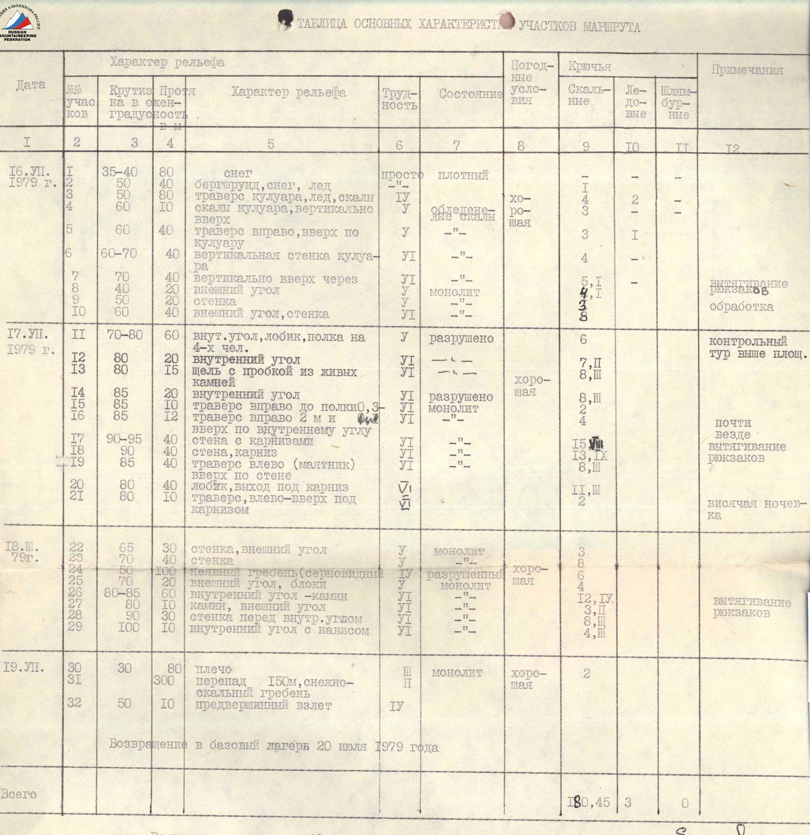
July 16, 1979 (Day 3).
Departed from the bivouac at 06:00. Enter the couloir via the snowslope. The couloir is initially not very challenging, with some ice and fractured rocks, but nothing falls from above. The steepness gradually increases from 40° to 80°. The couloir leads to a ridge under the base of the 1st wall.
Exited the couloir at 14:00, having broken through a snow plug at the exit. In the couloir, we placed:
- 21 rock pitons
- 3 ice screws
On the ridge, there's a good campsite. Three of us stayed to prepare the site for the tent, while a duo went ahead to further process the route.
On this day, we hung another 160 m of rope up the lower part of the wall. The wall is very steep but has a rather fractured structure here, with many loose stones. Steepness is around 70°, climbing is very challenging and requires utmost attention. We placed 18 rock pitons.
There's a campsite under the break on this section. In the second half of the day, the wall is hit by falling stones, requiring great caution.
July 17, 1979 (Day 4).
Departed from the bivouac at 07:00. Quickly passed the processed part of the wall and began processing the most challenging upper part. Here, we set up a control cairn.
- Ascend via an internal corner (30 m)
- Then rightwards via an external corner
- Traverse under a system of cornices
The system of cornices is traversed using ladders. There are many cornices in succession. The wall is vertical. We approach a large cornice, look around. It seems there's an exit left onto an external corner. On the external corner, a path is visible leading to the third section of the wall – a crescent-shaped ridge with snow patches to the left, leading under the upper part of the wall.
We didn't manage to reach a good campsite this day, so a trio camped at the top, each hanging on their pitons, while a duo camped on a small ledge below (0.3×1.0 m).
For the day:
- Pitons placed for safety – 85
- For creating artificial holds – 31
- Distance covered during the day – about 300 m.
July 18, 1979 (Day 5).
The night passed calmly. We started work early. Retrieved the remaining backpacks, the duo caught up, and soon we continued onto the start of the crescent-shaped ridge forming the beginning of the couloir that divides the wall into two parts.
Here:
- We had a good breakfast
- Had tea
- Built a second control cairn
From the control cairn, we proceeded straight up steep, heavily fractured rocks under an overhang. Left and up via rocks with ice – exit under the base of the upper tower (about 100 m from the control cairn).
As planned, the logical path was via the external corner to the right of a large grotto:
- First straight up
- Then right – into a chimney
- Up the chimney – exit to the left side (the chimney ends in an overhang)
- A bit up
- Then right and over the overhanging wall using a ladder – exit onto the shoulder
The section is very challenging. The leader pulled the backpacks up the pre-summit tower. On the shoulder – campsite.
July 19, 1979 (Day 6). From the campsite, via a simple slope (large blocks), exit onto a snowy ridge. The ridge curves right to left, leading to the summit. On the ridge, on the way to the summit, there are small elevations. On the second elevation, we leave a 3rd control cairn. The summit is reached via a snowslope and rocks of blocky structure. The summit consists of two rock outcrops of equal height. On the left outcrop, we build a summit cairn.
Descent from the summit into the cirque between Surkhu and Ravand peaks:
- via scree ledges and snowslopes,
- initially keeping to the right part,
- then exiting onto a small median ridge.
Avoid exiting into the couloir as stones fall through it. Descent time from the summit to the glacier – 3–4 hours.
Then:
- Descend into the valley to the right of the waterfall,
- Ascend onto the ridge leading to Komurzang peak,
- Descend down into the base camp.
On this day, we didn't manage to descend to the camp and camped on a grassy slope. The next day (July 20, 1979 – 7th day of ascent), we descended in an hour and were back at the base camp by 09:00.
Protocol #5
Analysis of the ascent made by the SKA MVO alpinist group to Surkhu peak via the western wall (right of the central couloir).
| Group composition: | |||
|---|---|---|---|
| Yefremov N.L. | CMS | leader | |
| Andreyev S.V. | CMS | participant | |
| Balakin A.V. | CMS | participant | |
| Vitsev V.V. | CMS | participant | |
| Nikolayev V.Ya. | CMS | participant |
Attendees:
- Training release officer Demchenko A.S., ICMS
- Training participants
Yefremov: Surkhu peak is located in the Ravang gorge. Its sheer western wall is visible from the Garmuchina settlement and caught our attention upon approaching the base camp. We made reconnaissance trips to survey the gorge, approaches to the peak, and study the wall.
As reconnaissance showed:
- A ridge extends from Surkhu peak, terminating in a virtually vertical wall.
- The wall has a couloir-ridge dividing it into two parts.
- The right part has a western exposure, and the left part has a northwestern exposure.
The entire wall can be conditionally divided into 4 belts by height:
- lower,
- middle (main part),
- belt of the crescent-shaped counterfort,
- upper belt of the tower.
Above the tower, a gentle ridge leads to the summit.
We departed from the base camp after lunch. We had to spend the night in the canyon due to high water, which made it impossible to pass along the river. Then, and up the riverbed filled with snow, we exited onto the right (by the route) slope and traversed to approach the snowslope leading into the cirque under the route. The cirque is small, with a convenient campsite, water, and close to the start of the route. We finalized the route variant. In the evening, we made footprints in the snow and hung a rope.
The next day, we started on the route at 06:00. The Vitsev – Nikolayev duo worked ahead. On this day, we exited via the couloir under the base of the central wall and set up a campsite. The Vitsev – Balakin duo hung another 160 m of rope. On the central part of the wall, the Yefremov – Vitsev duo worked ahead. Climbing is extremely challenging; about 120 meters involve a system of overhanging belts. This system of cornices on the right part of the wall turns into one huge cornice. The entire section is traversed using ladders with double rope. On the route, we only heard: "Hand out the white, Choose the red." This day was the most tense and required very hard work. As much as we tried, we couldn't reach the crescent-shaped ridge in a day. The duo camped on a tiny ledge below (they could at least sit), while the trio hung all night on the wall, fortunately with a warm night.
The next day, we began work early, retrieved backpacks, and continued onto the counterfort. Here, we had breakfast. We examined the summit tower. The Balakin – Vitsev duo worked ahead. The exit onto the tower proved very challenging. Again, work with ladders, pulling backpacks, and we established a campsite very late. The further path to the summit presented no particular difficulties. On the summit, we built a cairn and left a note. The descent from the summit into the cirque between Surkhu and Ravand peaks took about 3 hours.
To summarize, the route is very logical, beautiful, and challenging. In terms of the extent of rock sections, the route can be compared to routes on Zindon peak (Yefremov and Shumilova). Our group has climbed Yefremov's route and a significant part of Shumilova's route, so I can judge this objectively. I believe the route we took up Surkhu's western wall can be assessed as a 6B category of difficulty. On the route, the group worked very cohesively and efficiently. All members showed their best sides. The most challenging sections of the wall were first climbed by Vitsev, Balakin, and Yefremov, allowing for the most rational passage of the entire wall.
Vitsev: I really enjoyed the ascent. I've never climbed walls like this before. This route is much more challenging than, for example, the route on Maria peak (Vinokurov's route).
Andreyev: I really liked the route we took. It's much more challenging than all the 5B category routes I've climbed so far, including the qualifying routes on Ulu-Tau-Chana and Dzhailik peaks. Team members have made several joint ascents on 5B and 6B category routes, so even on the most challenging sections, the team works cohesively and very quickly.
Nikolayev: Among the most challenging routes I've climbed, this one stands out for its technical difficulty, requiring the highest alpine technique. The overhangs on a significant part of the route and the need for multiple and prolonged use of ladders indicate the route's high complexity. In terms of complexity, I can compare this route to routes on Zindon peak.
Balakin: I agree with my teammates that this route surpasses the complexity of our previously climbed 5B category routes. A positive aspect of this route is that all extremely challenging sections can be climbed using artificial holds without resorting to piton hammering. The ascent gave me great pleasure.
Demchenko: Congratulations to the group on an excellently completed, very challenging route. The extent of the challenging sections, their steepness reaching 100°–110°, the total number of working hours, and their proportion spent on the most challenging sections show that the route's difficulty exceeds the 5B category. Considering that team members have previously completed a 6B category route on Zindon peak and several 5B category routes in the Caucasus (Ushba, Glavny Dombay, Mikhiri, Ulu-Tau-Chana, Saly-Nameh by the north wall), Tian Shan (Dzhigit peak), Fann Mountains (Rudaki, Maria), and others, I believe we should approach the classification commission with a proposal to assign the route on Surkhu peak via the center of the western wall to the 6B category of difficulty.
The analysis was conducted by release officer Demchenko A.S.; the protocol was compiled by Nikolayev.