
Ascent Passport
- Ascent class — technical
- Ascent area — Central Pamir, Vanchsky Ridge
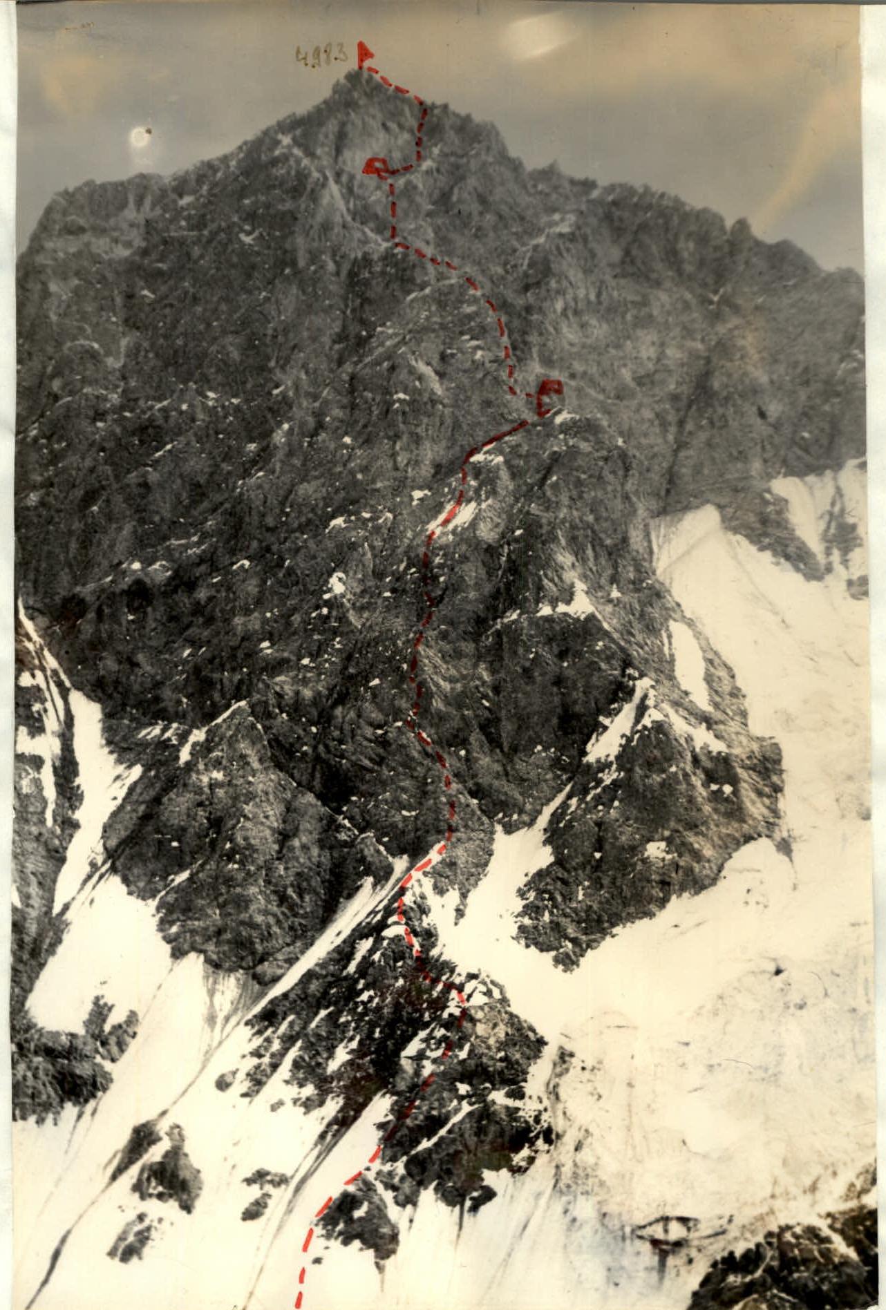
- Peak, its height, and ascent route: Western peak p. 4983 (Peak Belorussian Partisans) via the North face
- Estimated difficulty category — 5B
- Route characteristics: height difference — 950 m, average steepness — 70–75°
- Pitons driven: For belaying: a) rock — 148 b) ice — 9 c) bolt — — For creating ITO: 8
- Total climbing hours — 31.5 h
- Number of bivouacs and their characteristics — two bivouacs, sitting, in a tent
- Full names of participants, their sports qualification: ACHASOV Oleg Vladimirovich CMS GURIN Nikolai Ivanovich CMS GORYUNOV Oleg Evgenievich 1st sports rank VOYNOV Gennadiy Mikhailovich 1st sports rank
- Team coach — Bregman Eduard Emmanuilovich
- Date of departure and return: Departed on August 11, 1979. Returned on August 13, 1979.
Description of approaches to the route. From the base camp, located near the lakes on the bank of the Vanch River, to the Shaugada gorge — 1.5–2 h by road. There is a trail along the right bank of the Shaugada River. 4 h walk along the trail to the snow bridge over the Shaugada River, cross the bridge to the left bank and exit to the cirque formed by p. 4906–4841–4983 (2 h). In case the snow bridge is destroyed:
- follow the right bank to the glacier tongue,
- cross to the left bank of the Shaugada River,
- exit to the cirque via the moraines (3 h).
Bivouac sites on the moraine under the slopes of p. 4906. Peak 4983 is a massif with three distinct peaks, the highest being the Western one (this was visible from the summit). The peaks are separated by depressions about 200–250 m deep.
- The north faces of the Central and Eastern peaks are also of interest from an alpinist's point of view.
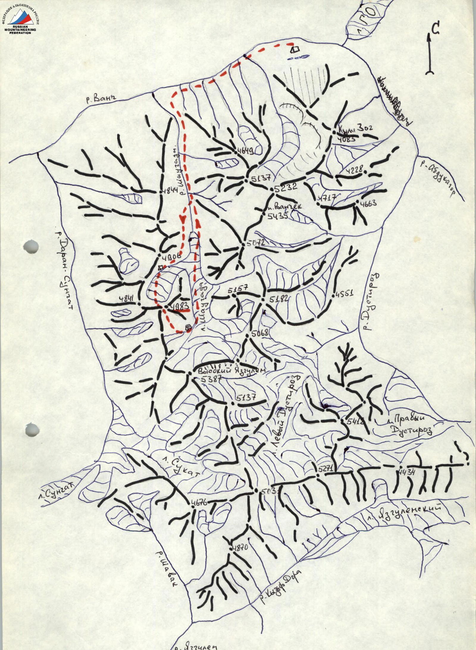 Table I
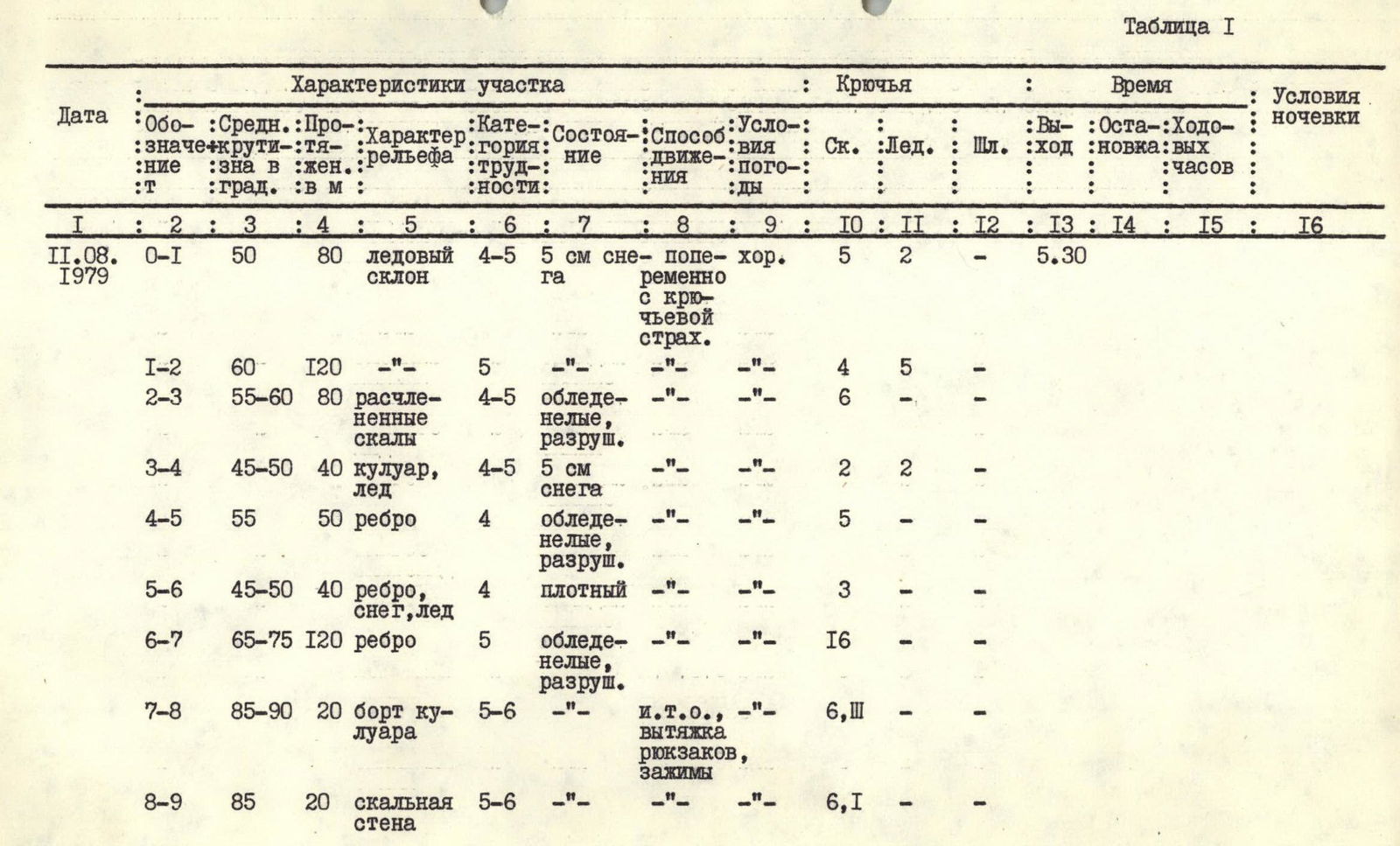
| Date | Section | Steepness | Length, m | Terrain | Diff. cat. | Condition | Movement method | Weather | Rock pitons | Ice pitons | Bolt pitons | Start | Stop | Climbing time | Bivouac |
|---|---|---|---|---|---|---|---|---|---|---|---|---|---|---|---|
| 11.08.1979 | 0–1 | 50° | 80 m | ice slope | 4–5 | 5 cm snow | alternating with piton belay | good | 5 | 2 | 5 h 30 min | ||||
| 1–2 | 60° | 120 m | 5 | destroyed | alternating | 4 | 5 | ||||||||
| 2–3 | 55–60° | 80 m | fractured rocks | 4–5 | icy, destroyed | alternating | 6 | ||||||||
| 3–4 | 45–50° | 40 m | couloir, ice | 4–5 | 5 cm snow | alternating | 2 | 2 | |||||||
| 4–5 | 55° | 50 m | ridge | 4 | icy, destroyed | alternating | 5 | ||||||||
| 5–6 | 45–50° | 40 m | ridge, snow, ice | 4 | firm | alternating | 3 | ||||||||
| 6–7 | 65–75° | 120 m | ridge | 5 | icy, destroyed | alternating | 16 | ||||||||
| 7–8 | 85–90° | 20 m | couloir edge | 5–6 | ITO, rucksack hauling, jammers | alternating | 6 | 11 | |||||||
| 8–9 | 85° | 20 m | rock wall | 5–6 | alternating | 6 | 1 | ||||||||
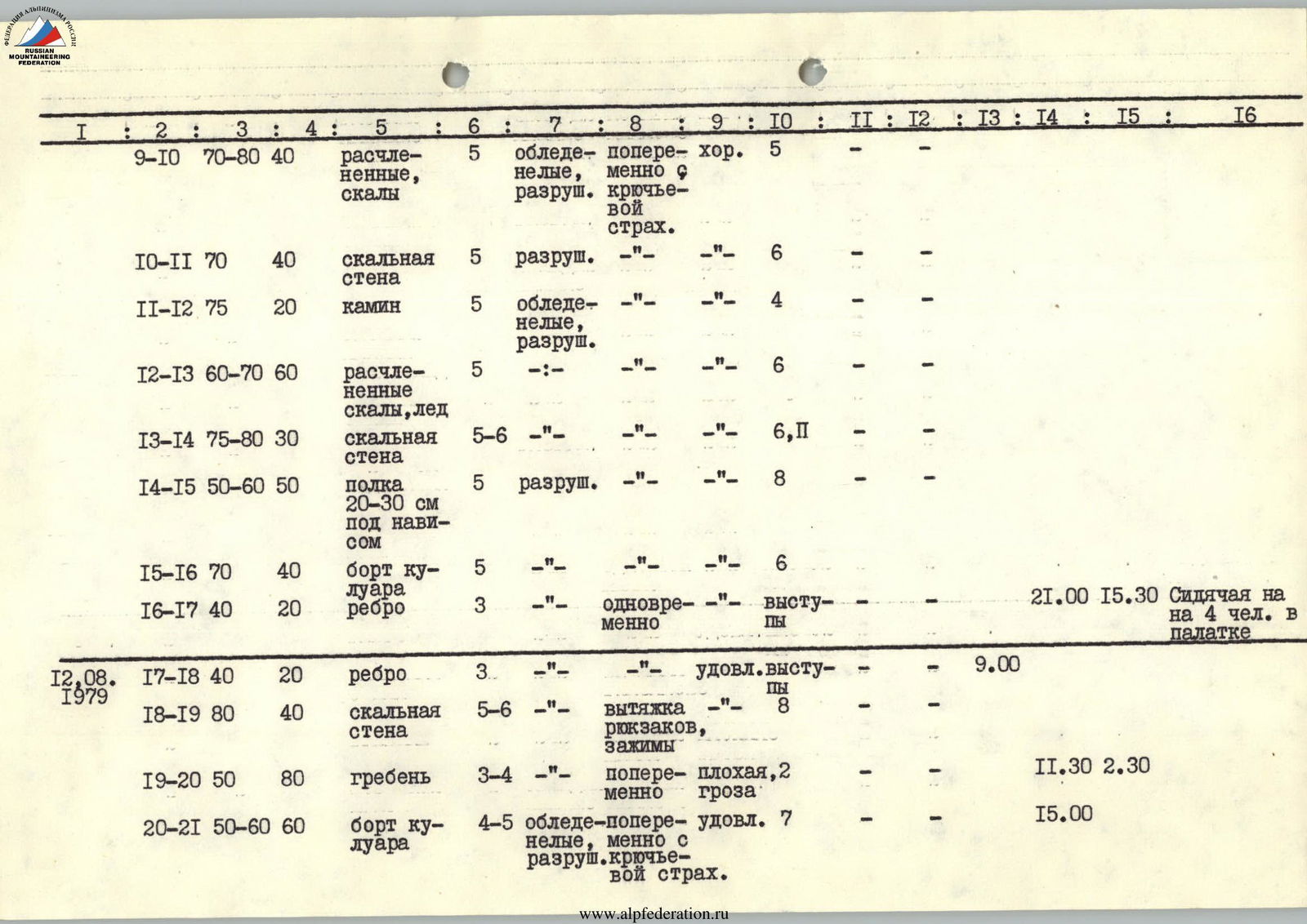
| 9–10 | 70–80° | 40 m | fractured rocks | 5 | icy, destroyed | alternating with piton belay | good | 5 | |||||||
| 10–11 | 70° | 40 m | rock wall | 5 | destroyed | alternating | 6 | ||||||||
| 11–12 | 75° | 20 m | chimney | 5 | icy, destroyed | alternating | 4 | ||||||||
| 12–13 | 60–70° | 60 m | fractured rocks, ice | 5 | alternating | 6 | |||||||||
| 13–14 | 75–80° | 30 m | rock wall | 5–6 | alternating | 6 | 11 | ||||||||
| 14–15 | 50–60° | 50 m | ledge 20–30 cm under an overhang | 5 | destroyed | alternating | 8 | ||||||||
| 15–16 | 70° | 40 m | couloir edge | 5 | alternating | 6 | |||||||||
| 16–17 | 40° | 20 m | ridge | 3 | simultaneous | ledges | 21:00 | 15:30 | Sitting on 4 people in a tent | ||||||
| 12.08.1979 | 17–18 | 40° | 20 m | ridge | 3 | satisfactory | ledges | 9:00 | |||||||
| 18–19 | 80° | 40 m | rock wall | 5–6 | rucksack hauling, jammers | 8 | |||||||||
| 19–20 | 50° | 80 m | ridge | 3–4 | alternating | poor, storm | 2 | 11:30 | 2 h 30 min | ||||||
| 20–21 | 50–60° | 60 m | couloir edge | 4–5 | icy, destroyed | alternating with piton belay | satisfactory | 7 | 15:00 | ||||||
| 21–22 | 80–90° | 50 m | rock wall | 5–6 | icy, destroyed | ITO, rucksack hauling, jammers | satisfactory | 8 | 1 | ||||||
| 22–23 | 60–70° | 30 m | couloir, ice, rocks | 5 | snowy | alternating with piton belay | 6 | ||||||||
| 23–24 | 45° | 20 m | ledges, ice, rocks | 4 | alternating | 5 | 21:00 | 6:00 | Sitting on 4 people in a tent | ||||||
| 13.08.1979 | 24–25 | 70° | 40 m | couloir, ice, rocks | 5 | destroyed, snowy | alternating | 5 | 12:00 | ||||||
| 25–26 | 75–85° | 50 m | ridge, wall | 5–6 | destroyed | rucksack hauling | 8 | ||||||||
| 26–27 | 60° | 30 m | rocks with ledges | 4–5 | alternating with piton belay | good | 4 | ||||||||
| 27–28 | 10–50° | 120 m | ridge | 3 | simultaneous | 1 | 17:30 | 7 h 30 min |
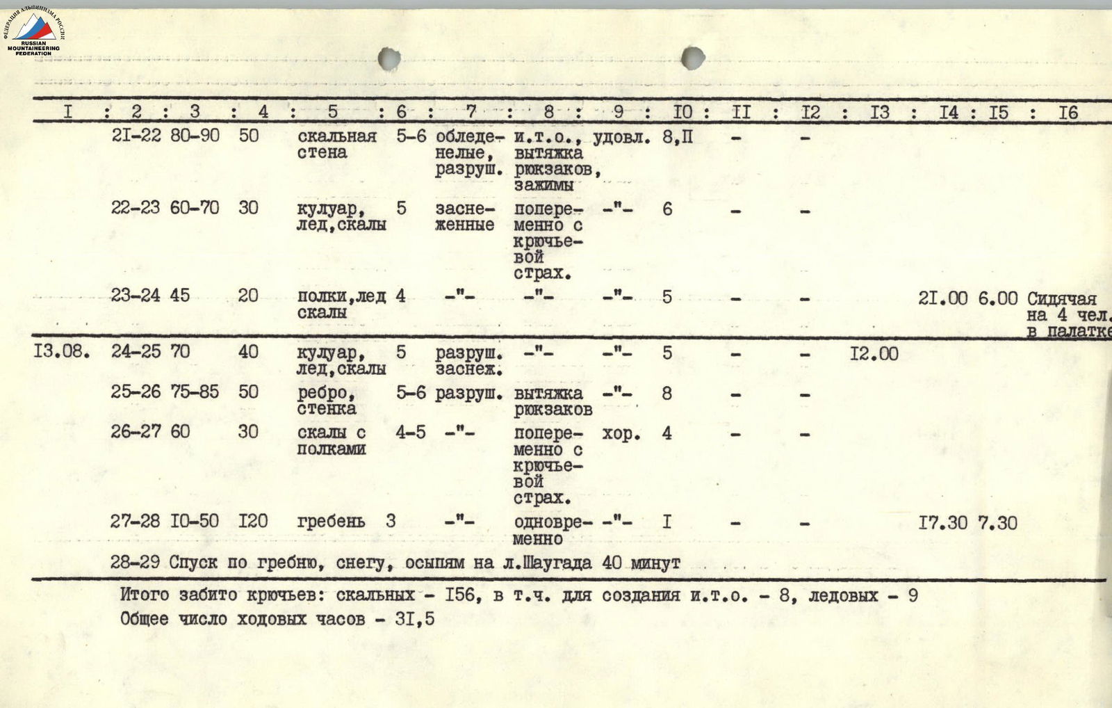
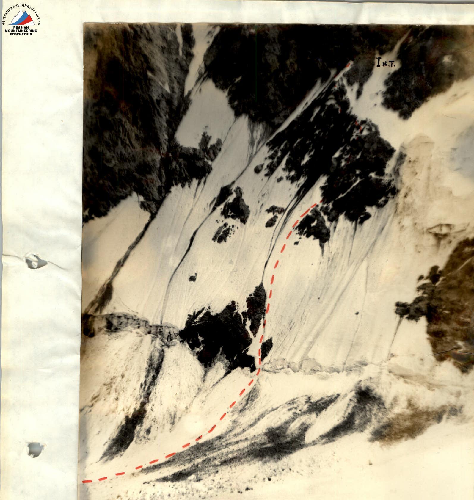
28–29. Descent along the ridge, snow, scree to Shaugada glacier — 40 min. Total pitons driven: rock — 156, including 8 for ITO, ice — 9. Total climbing hours — 31.5.
View of the route from under peak 4906.
Brief explanation of the table
Due to the lower part of the route being exposed to rockfall in the second half of the day (after 15:00), sections R0–R6 should be climbed early in the morning.
R0–R1. The bergschrund is crossed to the right of the rock island that overlaps it, then 80 m along the rocks on ice (crampons). Belay is mostly on the rocks.
R1–R2. The direction of movement is towards the rock island below the bastion. Ice, местами under 5 cm of snow.
R2–R3. Along the left part of the rock island to the couloir that crosses it. Live rocks.
R3–R4. Crossing the couloir, exit to the rock ridge leading to the base of the bastion.
R4–R5. Along the rock ridge, ascent to the snow-ice ridge leading to the base of the bastion. Live rocks.
R5–R6. Along the firm snow ( местами ice) of the ridge — exit to the base of the bastion. At the junction of the ridge with the bastion — 1st control point.
R6–R7. Along the destroyed steep rocks of the central part of the bastion. Rocks are snowy, местами icy.
The bastion consists of three pillars separated by couloirs. Direction of movement:
- Left — up
- To the edge of the couloir separating the 2 pillars of the bastion
- To the yellow overhanging rocks
R7–R8. The couloir is heavily fractured. Along its edge, bypassing the overhanging rocks, 5 m left along a narrow ledge under an overhang (without a rucksack), then along very steep rocks — exit to the base of the rock wall.
The second climber also goes without a rucksack and removes intermediate pitons, after which the rope is hung straight up.
R8–R9. Along the steep, destroyed icy rock wall, exit to the system of implicitly expressed ridges in the central part of the bastion.
R9–R10. Along fractured rocks, местами with ice, left-up. Live rocks.
R10–R11. Along the rock wall straight up — exit to the base of the steep icy chimney.
R11–R12. Up the chimney — to the icy snowy rocks leading to the junction of the lower bastion with the yellow overhanging rocks.
R12–R13. Along the icy snowy rocks — to the rock wall under a ledge with snow.
R13–R14. Along steep rocks — to the start of a narrow ledge under an overhang. On sections R6–R13, the main landmarks are:
- yellow overhanging rocks.
R14–R15. Along the narrow ledge under the overhang right-up — in the direction of the edge of the North face. Movement with a rucksack is difficult, so it is desirable:
- the first to go without a rucksack
- the last to go without a rucksack.
R15–R16. A wide steep couloir leads to the edge of the wall. Along its edge to the ridge.
R16–R17. The North face is separated from the East ridge by a couloir. Along the ridge and ledges, the path down in the direction of the E. ridge — bivouac.
R17–R18. From the bivouac, left-up to the base of the rock wall leading to the ridge of the N. face.
R18–R19. Along very steep destroyed rocks straight-up to the ridge.
R19–R20. Along the ridge along the couloir separating the N. face and the E. ridge, in the direction of the yellow overhanging rocks.
R20–R21. The ridge is separated from the yellow rocks by an icy couloir. Along its edge to the base of the rock wall, leading again to the edge of the couloir.
R21–R22. Along steep, местами ice-covered rocks, starting at the junction of the couloir edge with the icy ledge going right to the red overhanging rocks:
- straight up, exit to the edge of the couloir (snow, ice).
R22–R23. With less snowfall on the route, an ascent variant is possible along the steep ascent to the right of the couloir. The couloir is closed by overhanging rocks. To the left — overhanging monolithic yellow rocks, under which a small snowy ledge. The couloir is crossed left-up under the yellow overhanging rocks.
R23–R24. Along the snowy ledge to the bivouac site.
R24–R25. Traverse the couloir right under the overhanging rocks to the steep ridge limiting the couloir on the right.
R25–R26. Along the ridge (caution, many live blocks) exit to strongly destroyed rocks leading to the E. ridge of p. 4983.
R26–R27. Along destroyed rocks, exit to the ridge. There are many live rocks on the ridge.
R27–R28. Along the ridge 30 m, from where there is a good descent along:
- rocks,
- scree,
- snow to Shaugada glacier (rucksacks left here) and further to the Western peak of p. 4983.
Descent to Shaugada glacier took 40 min. Along the left part of the glacier to its turn. Overnight stay on the glacier. Further along the central part of the glacier through the following elements:
- 3 icefalls
- trail
Possible bivouac sites:
- at the 1st control point (semi-reclined)
- on section R19–R20 (reclined)
- on the ridge
No spontaneous rockfall was observed on the route, as the rocks are mostly icy.
 Lower part of the route (section R0–R6)