
1. Ascent Passport
- Ascent class: technical
- Ascent area: Central Pamir, western spurs of the Academy of Sciences Range, in the upper reaches of the Krasnoarmeysky Glacier.
- Peak, its height, and ascent route: Peak "5145", first ascent, via the "triangle" of the north face.
- Proposed difficulty category: 5B
- Route characteristics: height difference — 1120 m, length of sections with 5–6 difficulty category — 1147 m, average steepness — 68°
- Number of pitons: rock 169, ice 39, bolted 0.
- Number of climbing hours: 53 hours.
- Number of bivouacs and their characteristics: 5 bivouacs, including 4 lying and 1 sitting, all in tents.
- Surname, name, patronymic of the team leader and participants, their sports qualification: Senchina Svyatoslav Vladimirovich, Candidate for Master of Sports, instructor, team leader Bolizhevsky Valery Konstantinovich, Master of Sports, instructor Gresko Yuri Mikhailovich, Candidate for Master of Sports, instructor Nikolaychuk Oleg Leonidovich, Candidate for Master of Sports, instructor Onysko Orest Stepanovich, Candidate for Master of Sports, instructor
- Team coach: Bolizhevsky Valery Konstantinovich, Master of Sports, instructor
- Date of departure and return: August 4 to 10, 1979.
1. Brief Geographical Characteristics of Peak "5145"
Peak "5145" (also marked as 5130 m on some maps) is located in the western spur of the Academy of Sciences Range, in the upper reaches of the Krasnoarmeysky Glacier.
This peak is clearly visible from the Geographical Society Glacier, from the point where the Krasnoarmeysky Glacier flows into it. When viewed from the lateral moraine of the Geographical Society Glacier along the "flow" of the Krasnoarmeysky Glacier, a beautiful, wide mountain is visible to the south, closing the valley; the mountain is almost entirely snow-covered, with a beautiful corniced ridge. Peak "5145" is elongated in a latitudinal direction.
- To the west, it is separated by a high ice col (Kavgolovsky Pass) from Peak "4710" (Peak Krasnoarmeyets).
- To the east, its ridge approaches the nodal Peak "5571", located in the Academy of Sciences Range.
- To the north, towards the upper plateau of the Krasnoarmeysky Glacier, the slopes of Peak "5145" drop away with very steep ice walls and rock outcrops. These walls are continuously swept by falling ice and snow fragments from the corniced ridge.
In the center of the north face, approximately on the line of the highest point of the peak, there is a rock "triangle" — an almost sheer triangular wall, up to 900 m high. The most realistic path of ascent up the north face of the peak, chosen by us for the first ascent, goes via this "triangle".
The approach to the north face of Peak "5145" is conveniently made from the "Dusty" camp near the tongue of the Geographical Society Glacier. The path initially follows the glacier to the point where the Krasnoarmeysky Glacier flows into it (5 hours). Here, in a convenient green "pocket" of the lateral moraine, are the "Army Overnight" camps. The path then continues to the left of the Krasnoarmeysky Glacier (1 hour) and directly along the glacier (another 3 hours) to a low rock spur on the upper plateau of the glacier under the wall of Peak "5145". Here, a convenient location for a storm camp is available.
The most expedient descent route from the summit goes along the eastern ridge towards Peak "5571". Descending along the narrow, icy ridge with snow cornices and individual rock pinnacles should be done to the lowest ice col of the ridge before a large pinnacle, beyond which the ascent of the southwest ridge of Peak "5571" begins. The descent from the col to the upper plateau of the Krasnoarmeysky Glacier is about 100 m. The difficulty of the descent route corresponds to category 4B–5A.
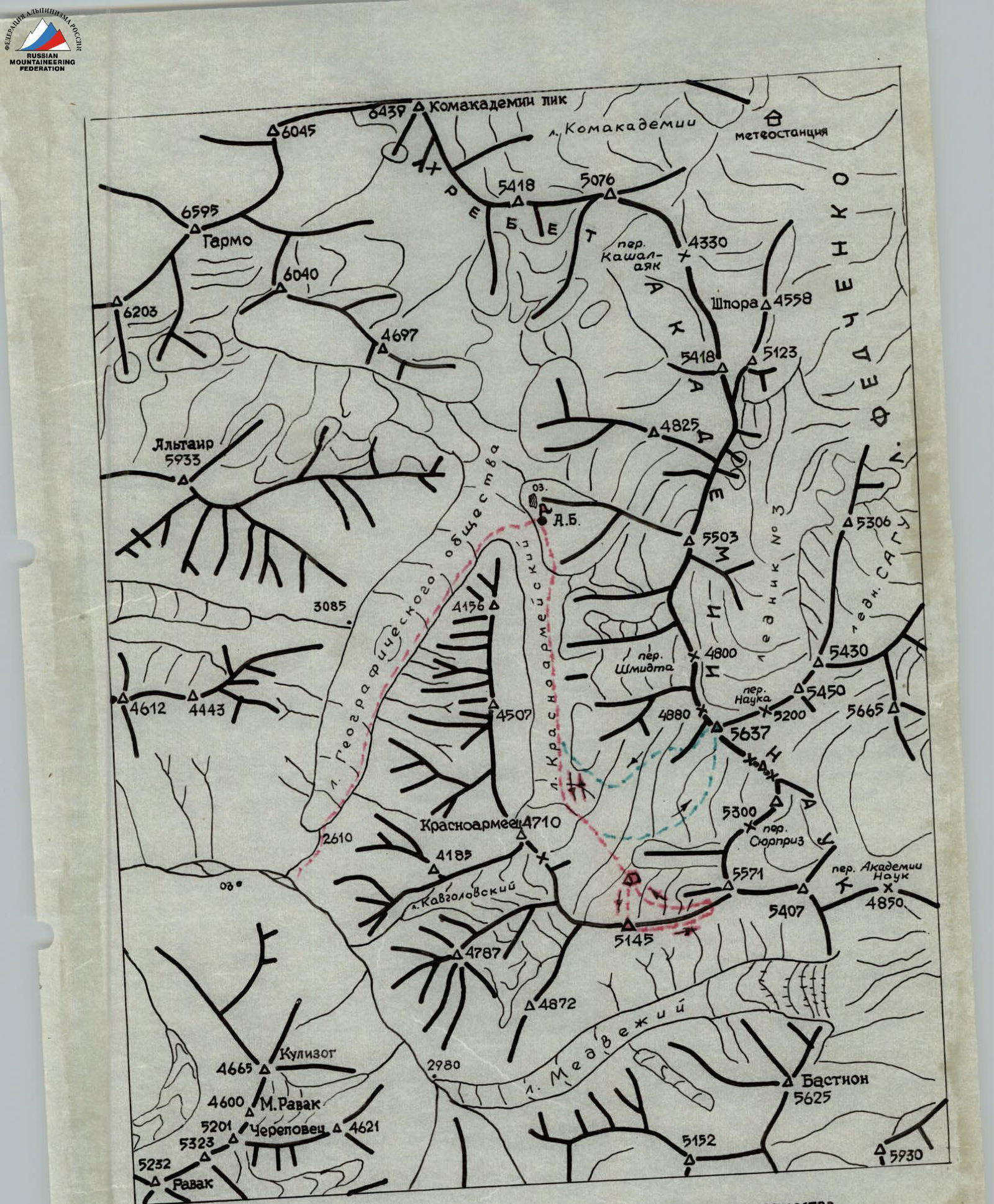
Fig. 1. Map-scheme of the Geographical Society and Krasnoarmeysky glaciers area (Central Pamir).
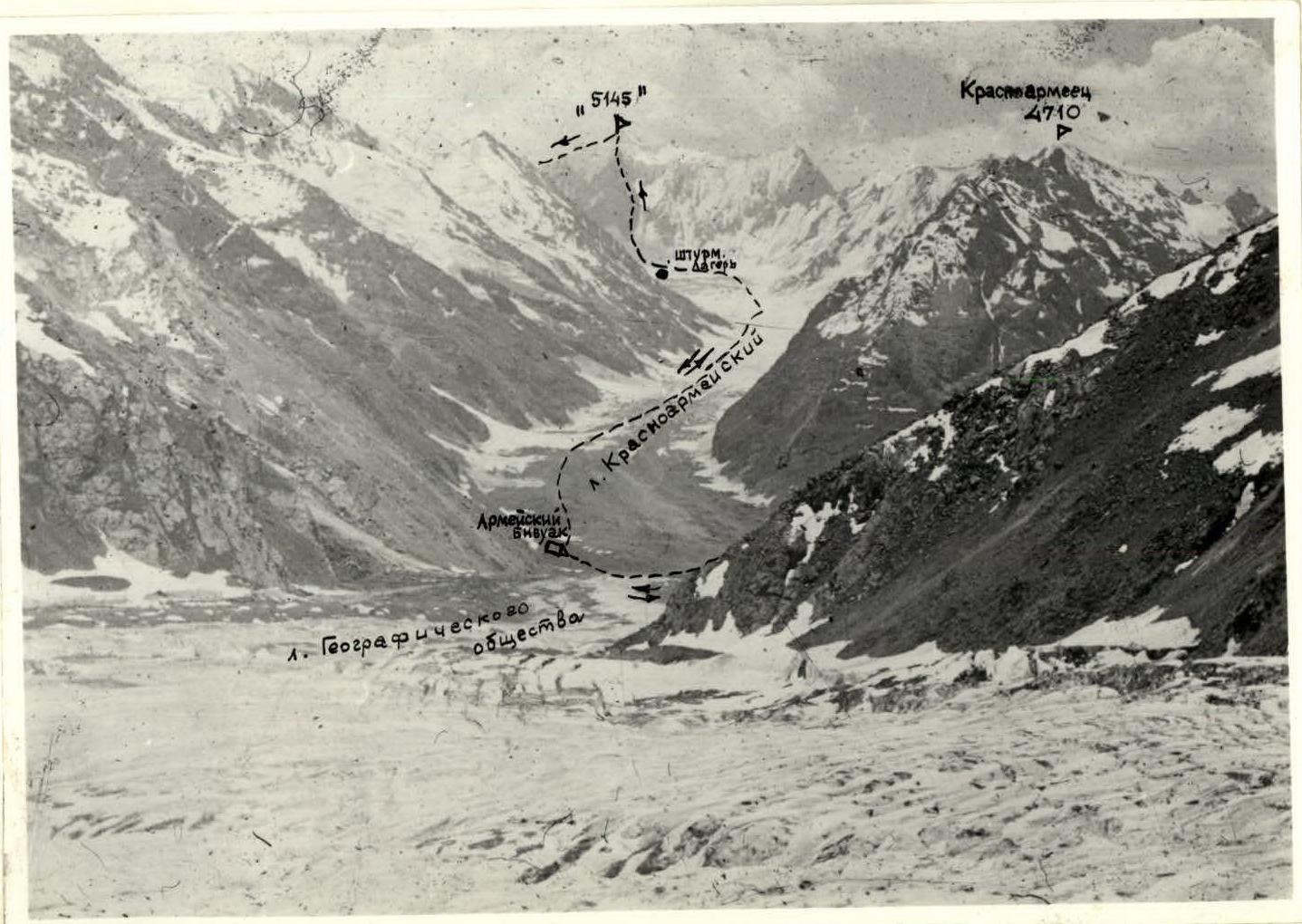
Photo 1. Panorama of the ascent area
2. Team Preparation for the Ascent
The PriKVO team in its current composition began to form in 1968, and since 1972 has been undertaking complex ascents, including those at the USSR Championships. For example, we have completed first ascents:
- on East Domбай-Ulgen via the center of the north face (1971);
- on Bodkhon via the right part of the west face (1972, 6B category);
- on South Ushba via the northwest face (1973, 6B category);
- on West Domбай-Ulgen via the center of the west face (1977);
- on Northeast Aksaut via the southeast face (1977); and repeated a number of complex wall routes.
Since autumn 1978, the team has been preparing for the SA and VMF Championship. During the preparation, the area of the 1979 Championship was studied using literary sources and ascent reports in the area:
- Vanch;
- Darvaz;
- Academy of Sciences Range.
Great attention was paid to conducting training sessions (general physical preparation, special training in rock and snow-ice techniques). A significant number of special equipment samples were manufactured and tested:
- titanium rock and ice pitons;
- wedges;
- chocks;
- ice axes with curved beaks and special sharpening for traversing steep ice slopes;
- lightweight down gear;
- other equipment.
A direct check of the team's readiness for the Championship was the ascents made in the Gissar Range area (Pamiro-Alai) during a general health-improving training camp in July 1979, namely:
- on the 1st West peak of Zamin-Karora via the center of the northwest wall, 6B category;
- on the West shoulder of Zamin-Karora via the west wall, 5B category.
After the team's arrival in the Championship area, from July 24 to 29, an acclimatization and training sortie was conducted, during which we finally chose the object of ascent for participation in the technical class of the Championship, namely the north face of Peak "5145" in the upper reaches of the Krasnoarmeysky Glacier. Simultaneously, an object was chosen for the team's second participation in the high-altitude technical class — the West face of Peak "5637", located nearby, in the Academy of Sciences Range.
As a result of visual observation of the wall directly from the upper cirque of the Krasnoarmeysky Glacier, a logical, interesting, and safe route was chosen via the right part of the "triangle" of the north face of Peak "5145", the regime of rockfall and icefall was studied, the necessary equipment set was clarified for a successful ascent in unstable weather conditions, safe bivouac locations were chosen, and a final tactical plan for the route was developed. On a rock island in the Krasnoarmeysky Glacier cirque, an excellent site for a storm camp was prepared, and a cache of part of the equipment and food was left. At the same time, the simplest descent route from the summit via the eastern ridge, which logically leads to the upper plateau of the Krasnoarmeysky Glacier, was carefully studied, and the passage through the icefall from the upper plateau was detailed. All this guaranteed a successful descent of the team even in very poor weather and lack of visibility.
The north face of Peak "5145" is fully visible along the entire length of the Krasnoarmeysky Glacier, starting from its confluence with the Geographical Society Glacier, ensuring "direct visibility" when organizing radio communication using VHF radios like R-147.
3. Organizational and Tactical Plans for the Ascent
The organization and tactics of the ascent were developed and implemented considering the specifics of a technically complex ascent in poor or unstable weather conditions. These considerations also determined the necessary set of food products and equipment items (see list).
On August 2, the team, along with the observation and communication group, as well as V. U.S., heading to Peak "5637" via the west face, departed from the "Dusty" camp along the Geographical Society Glacier to the "Army Overnight" camps.
On August 3, the team, in full strength, along with two participants from the auxiliary group, approached the wall (to the storm camp). Here, the conditions for radio communication with observers and V. Ufimtsev's group on Peak "5637" were finally clarified, and the main landmarks on the wall were agreed upon, relative to which information on the team's progress along the route would be transmitted. Throughout the ascent, radio communication with observers and V. Ufimtsev's group was conducted regularly and without interruption.
On August 4, the duo consisting of Senchina and Nikolaychuk passed the ice wall and bergschrund. They ascended using front points of 12-tooth crampons, utilizing ice screws and ice axes, as well as special ice axes, which allowed them to avoid cutting steps on the 60° slope. The rest of the team ascended the wall via the hung ropes (Bolychevsky–Gresko–Onysko rope team). From the beginning of the ascent and until the end of the wall passage, the lead climber went on a double rope. The other team members ascended the ropes using clamps like "Jumar". The lead climber went with a maximally lightened rucksack (containing only a down jacket in case of a sharp, unforeseen temperature drop), while the others carried rucksacks. Lifting rucksacks along the route was not anticipated because the entire wall is composed of extremely decomposed, though steep, rocks requiring extremely cautious movement.
By the end of the day, the weather had deteriorated sharply (fog, rain), but by this time, the entire team was already on a good platform under overhanging rocks at the end of the lower ice ledge.
On August 5, the Bolychevsky–Onysko rope team was the first to move out. In very poor weather conditions, they traversed about 3 ropes of the wall, bypassing the "Obelisk" pinnacle, and found a very convenient, wind-protected platform behind the pinnacle, at the base of the "Black" wall. By the end of the day, the entire team had moved to the new bivouac site.
On August 6, the weather was exceptionally poor. Nevertheless, the Nikolaychuk–Senchina duo managed to process the difficult "Black" wall — a key section of the lower part of the route, leading to the second ice ledge. Climbing the sheer wall, composed of dark quartzites, was extremely challenging, with the use of artificial holds in many places, and hook belays only (wedges, chocks). After processing the wall, the rope team descended to the bivouac.
On August 7, the entire team traversed the "Black" wall. Then, Gresko and Onysko, wearing crampons, traversed the second ice ledge (45° ice) and further up the decomposed rocks ascended to a ledge-crack at the base of the "Red" wall. Here, under overhanging rocks, the team settled for a sitting bivouac.
The first rope team managed to traverse the ledge-crack by the end of the day and scouted the further ascent route via the right part of the "Red" wall. Weather improvement was still not anticipated, and the second key section of the route lay ahead.
On August 8, in poor weather conditions, the Nikolaychuk–Senchina rope team traversed, with extremely difficult climbing using artificial holds on pitons and chocks, the sheer chimney and crack in the right part of the "Red" wall and reached the third ice ledge. The second rope team followed immediately behind the first. We hacked out a bivouac platform in the ice slope of the wall's shoulder. It was very cold.
Hail was falling. From below, they reported an unfavorable weather forecast for the coming days. But there was still enough strength, and the mood was cheerful.
On August 9, the Bolychevsky–Gresko rope team set out on the route at 6:00. It was very cold, but the weather had improved enough to work as a full team.
The decomposed rock ridge of the upper part of the "triangle" wall was traversed. Further, the path logically followed a steep ice couloir to the right of the ridge. In the couloir, Onysko led, wearing crampons, using ice screws for belays, and two ice axes for movement.
The couloir led to a snow ridge turning into an ice "knife edge", an extremely difficult section both technically and psychologically. Further lay the pre-summit snow slope and a short ice ridge leading to the summit. 15:00. There was no summit cairn.
Dense fog, visibility was practically zero, but the ridge was descending in all directions. On a rock outcrop, we built a large cairn, at the base of which we placed a note.
At 15:30, we began the descent along the eastern ridge. The descent path was logical and unambiguous. We descended quickly, wearing crampons. We very cautiously traversed areas where huge cornices hung to the north. Several times, we organized descents on a rope, leaving pitons with loops.
Late in the evening, we stopped for a bivouac in a snow depression near the place from which we were to descend to the glacier plateau.
On August 10, two sports descents down steep ice led us to the upper plateau of the Krasnoarmeysky Glacier. On the same day, we descended to our observers at the "Army Overnight" camps.
On August 11, the team returned to the base camp of the ВС.
List of Food Products
The team's nutrition was calculated based on a daily norm of 470 g per person. Hot meals were consumed in the morning and evening, and dry rations were eaten during the day. In the morning, the second rope team prepared an additional amount of tea, which was distributed into participants' flasks.
List:
| № | Product | Quantity |
|---|---|---|
| 1 | Dry biscuits | 2.0 kg |
| 2 | Indian tea | 0.1 kg |
| 3 | Sugar | 1.0 kg |
| 4 | Chocolate | 0.5 kg |
| 5 | Hard-smoked sausage | 2.6 kg |
| 6 | Canned fish (salmon) | 1.5 kg |
| 7 | Sardines in oil | 0.7 kg |
| 8 | Ukrainian lard | 0.6 kg |
| 9 | Freeze-dried soups | 0.6 kg |
| 10 | Freeze-dried meat | 0.6 kg |
| 11 | Onions | 0.5 kg |
| 12 | Ham | 0.7 kg |
| 13 | Red caviar | 0.2 kg |
| TOTAL: | 11.6 kg |
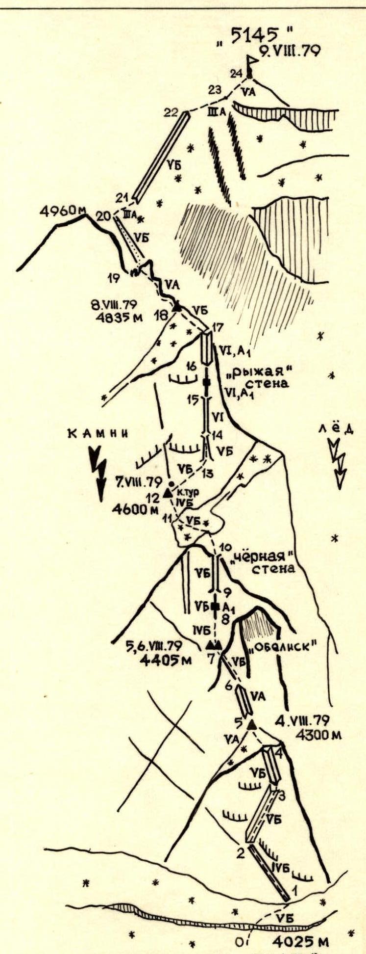
Fig. 2. Crokis of the route to Peak "5145" via the "triangle" of the north face.
Table of Main Characteristics of the Route of the First Ascent to Peak "5145" via the Triangle of the North Face
| Date | Designation | Average Steepness | Length in m | Relief Character | Difficulty | Condition | Weather Conditions | Insurance in m (Rock Pitons, Wedges, Chocks) | Insurance in m (Ice-) | Insurance in m (Bolted) | Passage and Length of Sections with Artificial Holds | Time of Departure and Stop | Bivouac Conditions |
|---|---|---|---|---|---|---|---|---|---|---|---|---|---|
| 4.VIII.1979 | 1 | 55° | 65 | Ice slope with bergschrund | 5 | hard ice | clear, cold | 2 | 5 | free climbing on 12-tooth crampons | 10:00 | ||
| 2 | 65° | 80 | Rock ledge | 4 | wet | fog | 5 | free climbing | |||||
| 3 | 80° | 75 | Inner corner | 5 | decomposed | fog, rain | 13 | — | |||||
| 4 | 90° | 50 | Inner corner-chimney | 5 | snow-covered | fog, hail | 8 | — | Lying, on ice under overhanging rocks | ||||
| 5 | 50° | 35 | Ledge with ice | 5 | ice | fog, hail | 3 | 1 | free climbing, crampons | 19:00 | |||
| Total for the day: | 305 | 31 | 6 | 9 climbing hours | |||||||||
| 5.VIII.1979 | 6 | 70° | 60 | Rock ridge | 5 | decomposed | fog, rain | 8 | free climbing | 11:00 | |||
| 7 | 90° | 45 | Overhang | 5 | wet | fog, rain | 8 | — | Lying behind the "Obelisk" pinnacle | ||||
| 8 | 70° | 40 | Rock wall | 4 | decomposed | fog, rain | 4 | — | 18:00 | ||||
| Total for the day: | 145 | 20 | 7 climbing hours | ||||||||||
| 6.VIII.1979 | 9 | 88° | 30 | Crack | 5 (Artificial Holds) | wet | fog, hail | 2 | Artificial Holds / 15 m / | 10:30 | same | ||
| 10 | 88° | 60 | Chimney | 5 | wet | fog, rain | 10 | free climbing | 17:30 | ||||
| Total for the day: | 90 | 12 | 7 climbing hours | ||||||||||
| 7.VIII.1979 | 11 | 45° | 35 | Ice ledge | 5 | ice | fog | 4 | 3 | free climbing | 9:00 | ||
| 12 | 70° | 45 | Rock slope | 4 | decomposed | fog, rain | 8 | — | Sitting, on a crack under overhanging rocks | ||||
| 13 | 85° | 40 | Ledge-crack | 5 | snow-covered | fog, snow | 11 | — | 19:00 | ||||
| Total for the day: | 120 | 23 | 3 | 10 climbing hours | |||||||||
| 8.VIII.1979 | 14 | 80° | 35 | Chimney-couloir | 5 | decomposed | clear | 6 | free climbing | 8:30 | |||
| 15 | 90° | 45 | Narrow chimney | 6 | wet | fog | 8 | — | Lying, on the ice shoulder | ||||
| 16 | 95° | 35 | Crack | 6 (Artificial Holds) | snow-covered | fog, hail | 4 | Artificial Holds / 15 m / | |||||
| 17 | 90° | 42 | Inner corner | 6 (Artificial Holds) | wet | fog, hail | 5 | Artificial Holds / 18 m / | |||||
| 18 | 45° | 50 | Ice shoulder | 5 | snow-covered | fog, hail | 1 | 5 | free climbing | 19:30 | |||
| Total for the day: | 210 | 24 | 5 | 11 climbing hours | |||||||||
| 9.VIII.1979 | 19 | 70° | 90 | Rock ridge | 5 | snow-covered | clear, frost | 17 | free climbing | 6:00 | |||
| 20 | 65° | 80 | Rock-ice couloir | 5 | snow-covered | cloudy | 2 | 10 | — | ||||
| 21 | 40° | 35 | Snow ridge | 3 | cornices | clear | 1 | — | |||||
| 22 | 55° | 130 | Ice "knife edge" | 5 | snow-covered | light fog | 13 | via ice axe | |||||
| 23 | 30° | 40 | Slope and ridge | 3 | snow | fog | free climbing | 15:00 | |||||
| 24 | 45° | 42 | Ice ridge | 5 | ice | fog, hail | 2 | free climbing | |||||
| Total for the day: | 417 | 20 | 25 | 9 climbing hours | |||||||||
| TOTAL: | 1284 m | 130 | 39 | Artificial Holds on 48 m | 53 climbing hours | ||||||||
| TEAM CAPTAIN | S. SENCHINA | TEAM COACH | V. BOLIZHEVSKY |
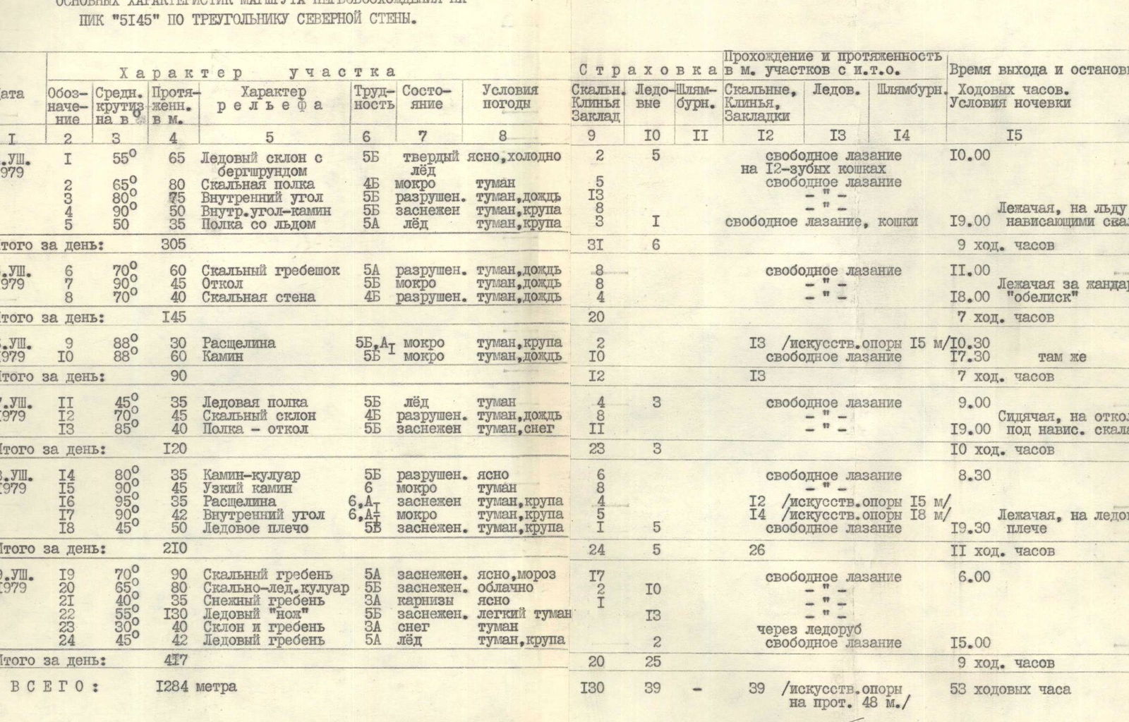
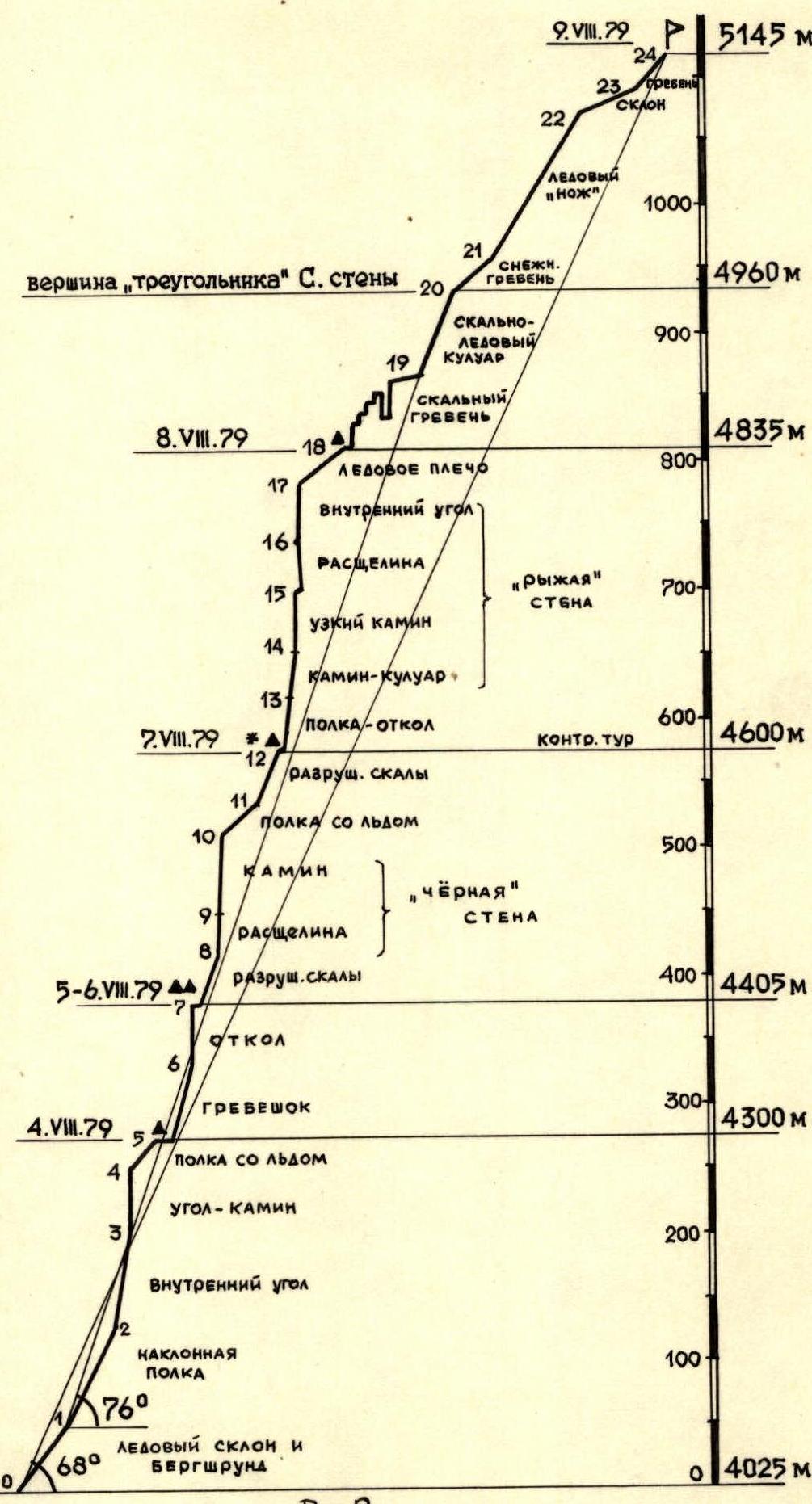
Fig. 3. Profile scheme of the route to Peak "5145" via the "triangle" of the north face.