Ascent Passport
- Ascent class - high-altitude
- Ascent area - North-Western Pamir, Akademiya Nauk Range
- Peak, its height, ascent route - p. Akhmad Doniša, 6666 m, western wall
- Proposed difficulty category - 6
- Route characteristics:
- height difference - 1666 m
- length of sections 5–6 difficulty category - 1295 m
- average steepness - 60°
- Pitons driven: rock - 96 pcs., ice - 26 pcs., bolt pitons for ITD - 3
- Number of working hours:
- ascent up the wall - 36 h, total - 49 h
- Number of overnight stays and their characteristics - five: three semi-reclining, two reclining
- Surname, name, patronymic of the leader, participants and their qualification:
- Khomutov Valeriy Vasil'yevich - MS - leader
- Ivanov Valentin Andreyevich - MSMK - deputy leader
- Masyukov Viktor Petrovich - MS - participant
- Myslovskiy Eduard Vikent'yevich - MSMK - participant
- Onishchenko Vyacheslav Petrovich - ZMS - " - "
- Putrin Valeriy Semenovich - MS - " - "
- Puchkov Vladimir Nikolayevich - MS - " - "
- Chyornyy Nikolay Dmitriyevich - MS - " - "
- Team coach - Ovchinnikov Anatoliy Georgiyevich, Honored Coach of the RSFSR, Honored Master of Sports
- Date of departure and return: July 7, 1980 - July 12, 1980
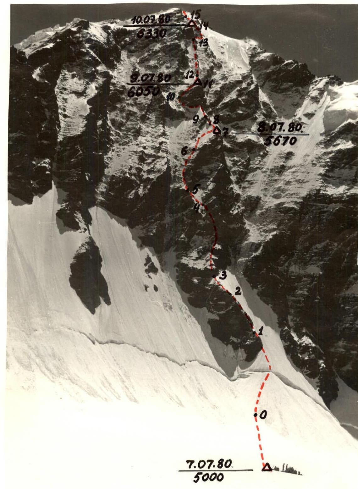
Photo 1.
Route Description
(Brief explanation of the table)
July 7, 1980. At 7:00, the team left the base camp near the lake at the confluence of the Walter and Moskvina glaciers.
We ascended the left moraine of the Moskvina glacier (orographically) for 2 hours to the upper reaches of the Moskvina glacier under the slopes of Pik Četyryokh. Another 2 hours of walking under the slopes of Pik Četyryokh, and we are at the assault camp near the tent with the cache left during the reconnaissance sortie.
At 12:00, the rope teams Puchkov—Putrin and Masyukov—Chyornyy started processing the initial part of the route. By 18:00, they processed 200 m of the route.
The weather is good. We prepare dinner and go to bed early, as tomorrow will be a busy working day.
July 8, 1980. Wake-up at 6:00. We have breakfast, pack up the tents, and at 8:00, we head to the wall. Within half an hour, we cross the glacier and reach the start of the route.
The route begins with a snowy slope turning into a snow-ice slope. The frost has hardened the snow and ice, so:
- we put on crampons.
The ice axe is driven in halfway but holds well. We approach the bergschrund, from which the processed part of the route (R0–R1) begins. The first rope (80 m) is fixed to the snow-ice slope, and the path goes along the left part of the ice gully.
By 10:00, intensive dry avalanches start coming down the gully, so we have to move even further left.
We reach the rocky ridge leading to the base of the rocky massif, which abuts the first rocky triangle.
We move on crampons because the ledges on the rocks are snow-covered, and the crevices are filled with ice. It's cold because the wall is only lit up by 12:00. The rocks become steeper but are still heavily snow-covered. The rocks are of a layered structure and are heavily destroyed (R3–R4). The 80 m rope is no longer needed; we throw it down the couloir to retrieve it on the way back. The Onishchenko—Khomutov rope team is working ahead.
Quite often, we encounter sheer walls 3–4 m high, which are difficult to overcome with a backpack. We decide to lighten the load on the first climber by making one backpack lighter.
In three places on the 10–15 m high walls, we organized rope hauling (photo 3). On short sections, this doesn't take much time.
Near the cross-shaped snow patch that feeds a huge icicle, we need to traverse left onto the rocks supporting the left edge of the rocky triangle (R4–R5). We studied this section through binoculars from the assault camp. The R4–R5 section consists of steep rocks with ice and snow. To find cracks for pitons, we have to:
- clear the snow.
We change the lead rope team; Puchkov—Putrin go ahead. We continue moving with fixed ropes throughout the day, as there are no sections where we can move autonomously. We reach the rocks on the left edge of the first triangle (R5–R6) by 16:00. We can already feel the altitude; the altimeter shows 5400 m.
There are no suitable places for overnight stays, as expected, so we need to keep moving upwards. After reaching the snow (R6–R7), we change the lead rope team again. Myslovskiy—Ivanov go ahead. The slope is in poor condition - a thin layer of wet snow on ice. We use ice pitons for protection.
Before reaching the ridge, the slope becomes steeper; Myslovskiy overcomes it without a backpack using his front points. When he reaches the ridge, he breaks through a snow cornice.
It's already dark when the last team member reaches the ridge, where the first ones are preparing sites for two tents. The last to "arrive" is Myslovskiy's backpack.
At 22:00, in the dark, we set up two tents on platforms cut into the ice. The semi-reclining overnight stay after such a day feels like paradise (photo 4).
July 9, 1980.
At 9:00, the first rope team, Masyukov—Chyornyy, begins moving along the snow-ice ridge with cornices. We use ice axes for protection.
We approach the rocky wall on the ridge (R8–R9). The rocks are steep, made of slate. Long pitons (up to 200 mm) go in well. It's cold, and the passage through the wall is slow.
After passing the snow-ice ridge, which abuts the base of the 2nd rocky triangle (R9–R10), we decide to gather and have a snack (photo 5). The fatigue from the previous day is starting to show.
The second rocky triangle is traversed along the rocks on the left edge. To the right are sheer monolithic walls going up and down into a deep couloir. The passage involves:
- traversing under the base (photo 6);
- exiting onto the rocks on the left edge (photo 7).
The rocks are slate blocks, snow-covered and quite destroyed.
Movement is in rope teams:
- Onishchenko—Khomutov go first (Onishchenko has a lightened backpack);
- then Myslovskiy—Ivanov lead;
- followed by Puchkov—Putrin.
We move with fixed ropes throughout the day. Climbing aids are constantly in use. By 18:00, we reach the snow-ice ridge and decide to set up tents at an altitude of 6050 m. We cut out platforms in the ice.
The weather was good throughout the day, but according to the evening radio communication, the forecast predicts worsening weather in the coming days. We decide to ascend higher than the planned overnight stay tomorrow, if possible - to the ridge.
July 10, 1980.
At night, the wind strongly rocked the tents. By morning, it started snowing, and the tents were getting covered. We got up early. By 9:00, there were breaks in the clouds, and we could start moving.
The character of the route on this day is a ridge interrupted by rocky walls. We overcome the walls directly. On the R12–R13 section, we had to use ladders - monolithic overhanging fragments 3–4 m high in two places.
Further, the ridge abuts the 3rd rocky triangle, from the base of which:
- we traverse 3 m to the right along a narrow ledge;
- then rappel 10 m down into a couloir;
- and continue to the opposite side of the couloir (R13–R14).
The snowfall makes movement difficult. The route is visible only in short intervals. Above us are snow-covered rocks with a steepness of 70–75°.
Fatigue and altitude are taking their toll; as a rule, the first rope team changes after every rope length.
We stopped for the night at 20:00 at an altitude of 6330 m. Further ahead, we could see steep snow-ice slopes, which we decided to overcome in the morning. Again, we do snow-ice work to build platforms. By 22:00, we are in our tents.
July 11, 1980.
The first two rope teams departed at 9:00. The second teams followed after packing the tents. After 2 hours of work on the snow-ice slope (R14–R16), we reached the junction of the Budanov and main ridges. It's foggy, with visibility of 50 m.
The path along the ridge is not technically difficult, but we need to avoid cornices. The cornices mostly hang to the right. We reached the summit at 12:00, took photos (photo 8), and began our descent. The descent took the whole day in poor visibility. We constantly organized rappels, and the last person climbed down, often using double ropes.
At 18:00, we stopped for the night. The altitude is 5600 m. The platforms were practically ready, under the shelter of a huge boulder.
July 12, 1980.
We departed at 9:00. The weather is improving, but there's still cloud cover at our level. We descended mainly using rappels. In the breaks between clouds, we could briefly see the descent route. On rocky sections, the last person descended on double ropes. In some places:
- the rope was difficult to pull through;
- once, Onishchenko had to climb up to free the rope from a rock crevice.
By 14:00, we were on the glacier at the assault camp site. At 18:00, our friends greeted us at the base camp. The ascent is over.
Team leader
(Khomutov)
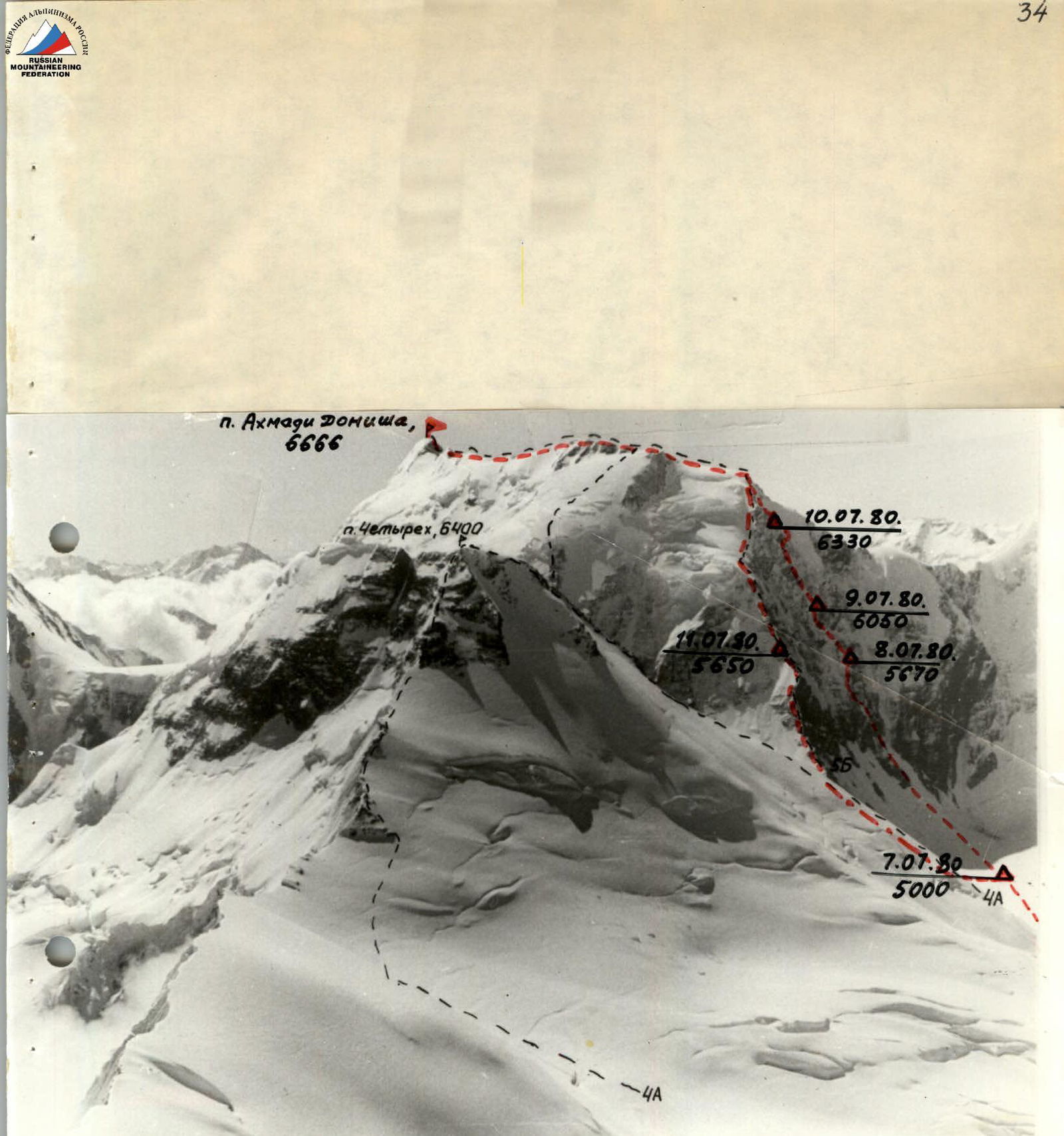
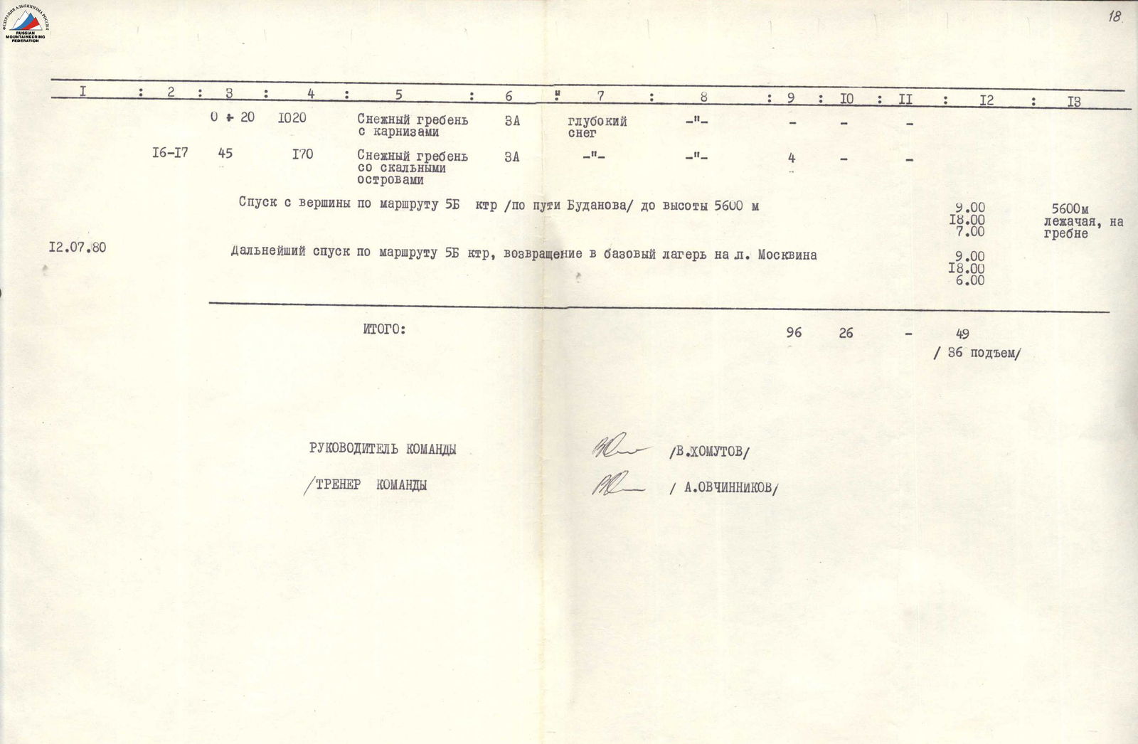
Photo 2. Table of main characteristics of the ascent route. Ascent route - Pik Akhmad Doniša via the Western wall.
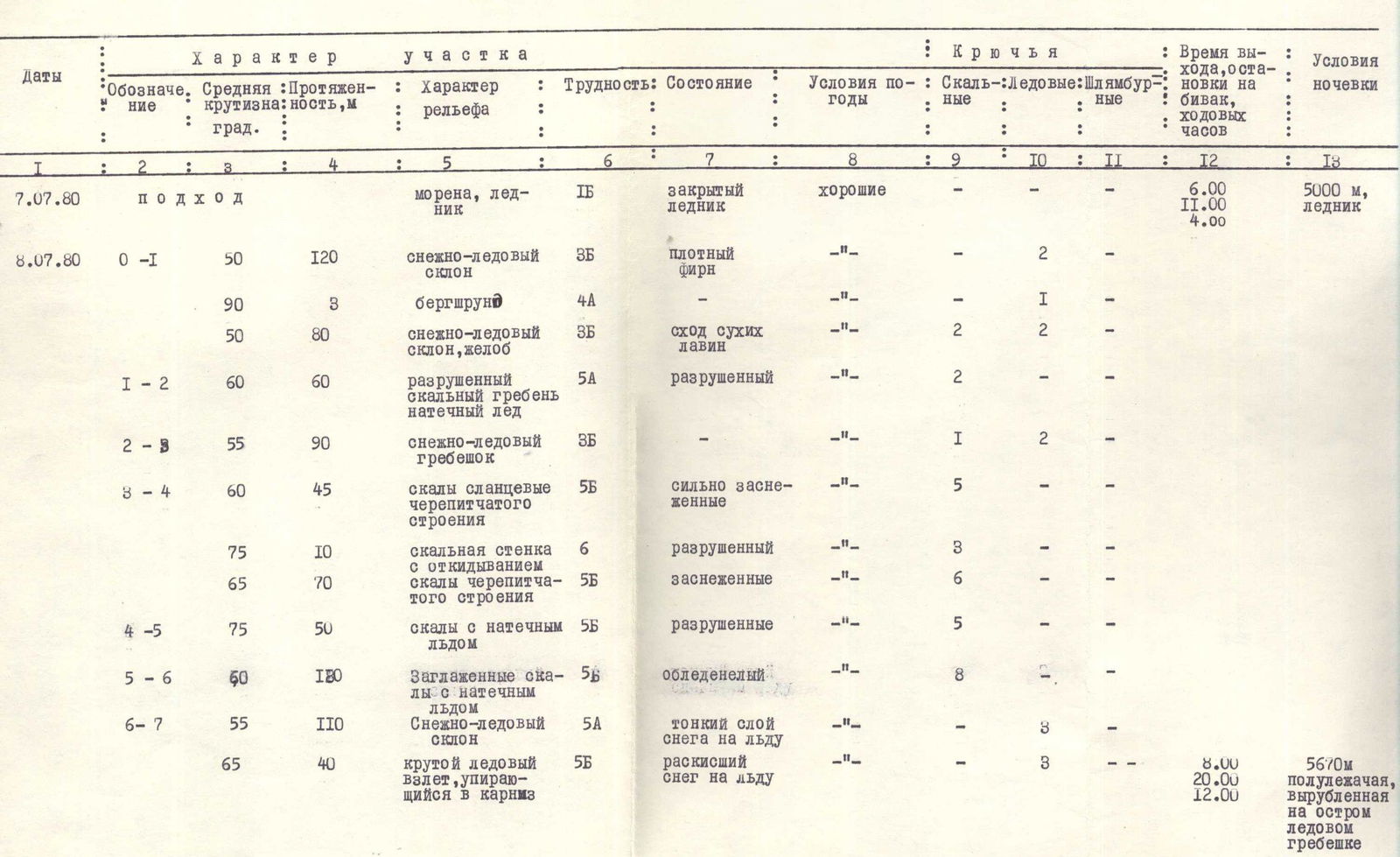
| 1 | 2 | 3 | 4 | 5 | 6 | 7 | 8 | 9 | 10 | 11 | 12 | 13 |
|---|---|---|---|---|---|---|---|---|---|---|---|---|
| Dates | Section | Avg. steepness, deg. | Length, m | Relief character | Difficult. | Relief condition | Weather conditions | Rock pitons | Ice pitons | Bolt pitons for ITD | Exit time, stop at a bivouac, working hours | Overnight stay conditions |
| July 7, 1980 | approach | moraine, glacier | 1B | closed glacier | good | — | — | — | 6:00, 11:00, 4:00 | 5000 m, glacier | ||
| July 8, 1980 | R0–R1 | 50 | 120 | snow-ice slope | 3B | dense firn | — | — | 2 | — | ||
| 90 | 3 | bergschrund | 4A | — | — | — | 1 | — | ||||
| 50 | 80 | snow-ice slope, gully | 3B | dry avalanches | — | 2 | — | — | ||||
| R1–R2 | 60 | 60 | destroyed rocky ridge, ice accretion | 5A | destroyed | — | 2 | — | — | |||
| R2–R3 | 55 | 90 | snow-ice ridge | 3B | — | — | 1 | 2 | — | |||
| R3–R4 | 60 | 45 | slate rocks with layered structure | 5B | heavily snow-covered | — | 5 | — | — | |||
| 75 | 10 | rocky wall | 6 | destroyed | — | 3 | — | — | ||||
| 65 | 70 | rocks with layered structure, with withdrawal | 5B | snow-covered | — | 6 | — | — | ||||
| R4–R5 | 75 | 50 | rocks with ice accretion | 5B | destroyed | — | 5 | — | — | |||
| R5–R6 | 60 | 180 | smoothed rocks with ice accretion | 5B | icy | — | 8 | — | — | |||
| R6–R7 | 55 | 110 | snow-ice slope | 5A | thin layer of snow on ice | — | 3 | — | — | |||
| 65 | 40 | steep ice rise abutting a cornice | 5B | wet snow on ice | — | 3 | — | — | 8:00, 20:00, 12:00 | 5670 m, semi-reclining, cut into a sharp ice ridge | ||
| July 9, 1980 | R7–R8 | 50 | 70 | sharp snow-ice ridge with cornices | 3B | — | good | — | — | — | ||
| R8–R9 | 70 | 45 | rocky wall | 5A | destroyed | — | 6 | — | — | |||
| R9–R10 | 60 | 60 | steep snow-ice ridge | 45 | — | — | — | 3 | — | |||
| 35 | traverse left to bypass the 2nd rocky triangle | 3B | snow-ice slope | — | 4 | — | — | |||||
| 65 | 45 | black rocks with ice accretion | 5A | snow-covered | — | 3 | — | — | ||||
| R10–R11 | 75 | 180 | steep icy rocks | 5B | — | — | 12 | — | — | |||
| R11–R12 | 50 | 45 | snow-ice ridge with cornices | 4A | — | — | — | — | — | 9:00, 18:00, 9:00 | 6050 m, semi-reclining, cut into a ridge | |
| July 10, 1980 | R12–R13 | 80 | 10 | rocky wall | 5B | destroyed | cloudy, gusty wind | 3 (1 for ITD) | — | — | ||
| 55 | 30 | snow-ice ridge | 3B | — | — | — | — | — | ||||
| 90 | 8 | sheer rocky wall | 6 | monolithic | cloudy, strengthening wind | 3 (2 for ITD) | — | — | ||||
| 60 | 40 | heavily dissected rocky ridge | 5A | destroyed | wind | 3 | — | — | ||||
| 75 | 12 | rocky wall | 5B | destroyed | — | 4 | — | — | ||||
| 60 | 50 | destroyed rocky ridge | 5A | destroyed | snow, gusty wind | 3 | — | — | ||||
| R13–R14 | — | 40 | traverse right to bypass the 3rd rocky triangle, crossing a couloir | 4А | — | — | 2 | — | — | |||
| 75 | 160 | icy rocks | 5Б | destroyed, snow-covered | snow with short breaks, wind | 11 | — | — | 9:00, 20:00, 2:00 | 6330 m, semi-reclining, two platforms cut into a snow-ice slope | ||
| July 11, 1980 | R14–R15 | 50 | 90 | snow-ice slope with rocky outcrops | 5A | dense firn on ice | fog, visibility 50 m | 4 | 2 | — | ||
| 60 | 90 | ice slope | 5B | — | — | 2 | 6 | — | ||||
| R15–R16 | 30 | 160 | snow-ice slope | 2B | open crevasses | overcast, snow, wind | — | — | — | |||
| R0–R20 | — | 1020 | snowy ridge with cornices | 3A | deep snow | — | — | — | — | |||
| R16–R17 | 45 | 170 | snowy ridge with rocky outcrops | 3A | — | — | 4 | — | — | |||
| Descent from the summit via route 5B /via Budanov's route/ to 5600 m | 9:00, 18:00, 7:00 | 5600 m, reclining, on a ridge | ||||||||||
| July 12, 1980 | Further descent via route 5B, return to the base camp on the Moskvina glacier | 9:00, 18:00, 6:00 | ||||||||||
| TOTAL: | 96 | 26 | — | 49 (36 ascent) |