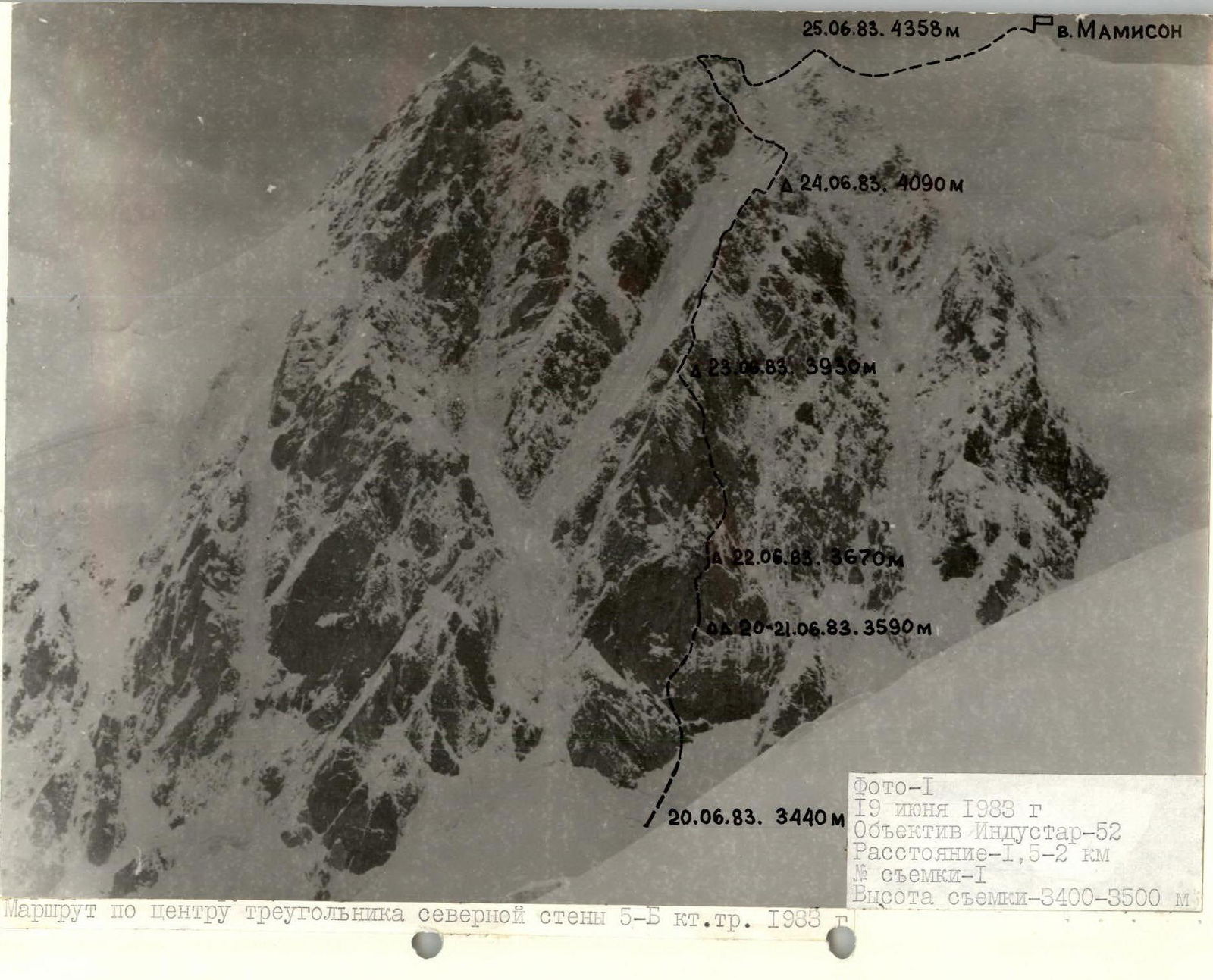
I. Climbing category — technical 2. Climbing area — Eastern Caucasus, Main Caucasus Range 3. Mamisontau (4358 m) — through the center of the northern wall triangle 4. Proposed — 5B cat. diff. combined (first ascent) 5. Height difference — 918 m
including the "triangle" — 490 m. Length — 1410 m. Length of 5–6 cat. diff. sections — 845 m, including 6 cat. diff. — 175 m.
Sections:
- 3518–3534
- 3596–3694
- 3730–3770
Average steepness of the "triangle" — 68° (7), including main sections — 80° (3488–3808)
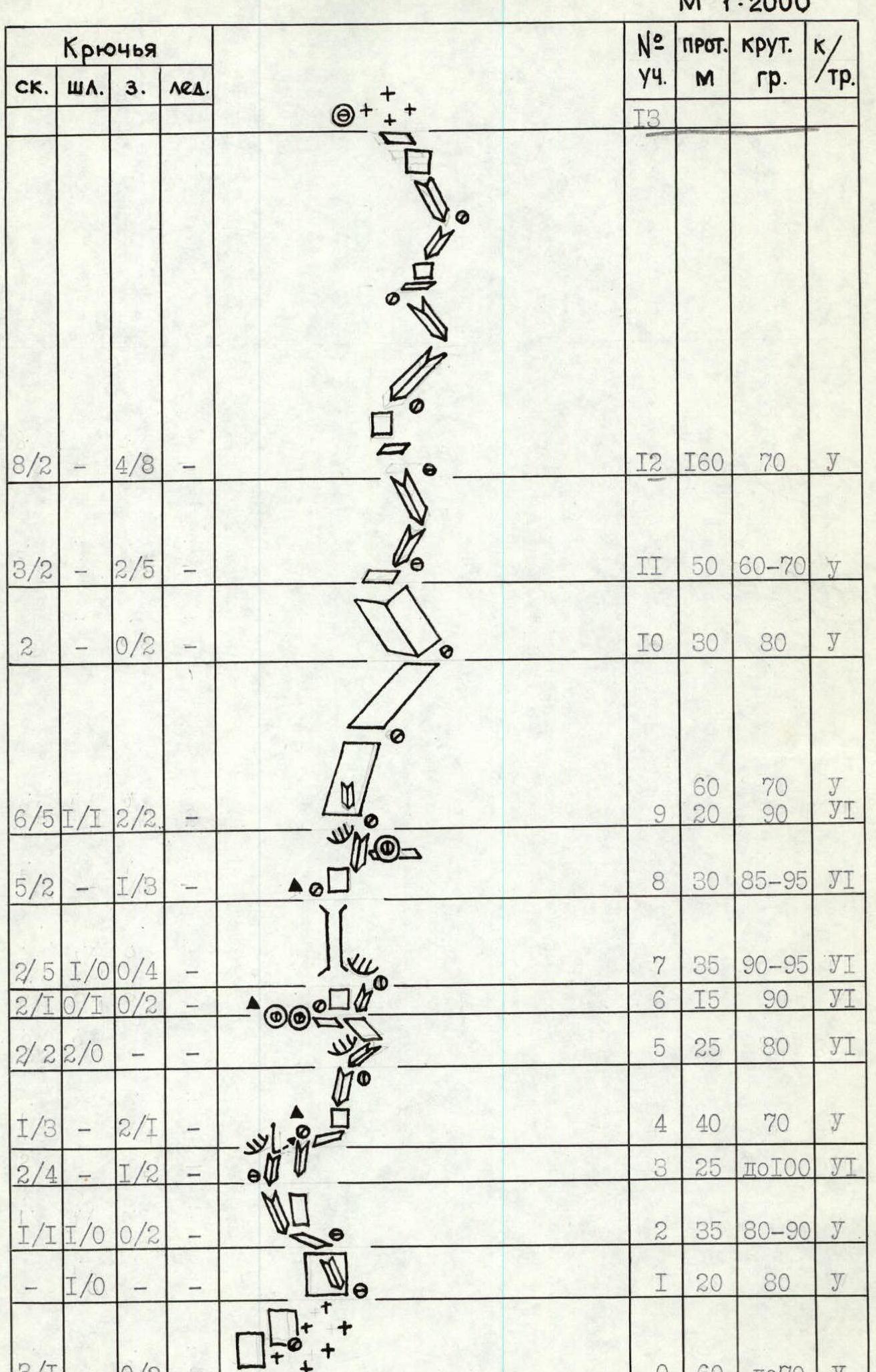
- Pitons driven:
| rock | bolt | nuts | ice |
|---|---|---|---|
| 59 | 9 | 14 | 8 |
| 31 | 2 | 22 | 0 |
- Team's working hours — 58 (6 days)
- Overnights: 1–3 — sitting, on narrow ice ledges, in a tent 4 — lying, on a platform cut out of ice, in a tent 5 — lying, in a snow cave
- Team of the "Torpedo" alpine camp
- Leader — Alexey V. Rusyaev — Candidate Master of Sports
Team members:
- Vyacheslav I. Glushko — Candidate Master of Sports
- Anatoly I. Kotelnikov — Candidate Master of Sports
- Gennady M. Kochan — Candidate Master of Sports
- Alexander N. Odintsov — Candidate Master of Sports
- Pavel D. Chaika — Candidate Master of Sports
- Senior coach — Mikhail M. Zakhozhiy, Master of Sports of the USSR Coach — Alexey V. Rusyaev
- Departure on the route — June 20, 1983 Reaching the summit — June 25, 1983 Return — June 25, 1983
The team scored 11 points after the ascent
- first ascent — 6 people × 1 = 6
- route 5B cat. diff. — 6 people × 0.5 = 3
- instructors of the alpine camp — 6 people × 0.25 = 1.5
- leader — 1 person × 0.5 = 0.5
Total 11 points

The tactical plan provided for the route to be completed with two overnights. Due to unstable weather in the area, a reserve day was planned for bad weather, and in case of prolonged bad weather, an extension of the control time was considered.
The actual completion of the route was done with an extension of the control time, which corresponded to the tactical plan. The ascent time coincided with severe weather that affected the entire Caucasus. It was during this time that the USSR Championship team of the Armed Forces, competing in Dombay, withdrew.
The route was completed from June 20 to 25, over 58 working hours without prior processing.
The team consisted of 6 people: Rusyaev, captain, coach, Glushko, Kotelnikov, Kochan, Odintsov, Chaika.
Considering the strong and even composition, the work of the rope teams was organized on the route by sections:
- R0–R1 — Glushko–Kotelnikov
- R1–R9 — Rusyaev–Odintsov
- R9–R13 — Glushko–Kotelnikov
- R13–R16 — Kochan–Chaika
- R16–R17 — Rusyaev–Odintsov
- R17–R19 — Kochan–Chaika
The first in the rope teams typically changed once a day, working without a backpack. All participants were provided with double insurance.
Tasks of the rope teams:
- 1st — fixing ropes
- 2nd — moving along the ropes, supplying the 1st team with equipment
- 3rd — moving along the ropes, forwarding equipment, removing ropes
The movement of the rope teams along the ropes was independent. Processing was planned from section R9. Bivouac equipment was designed for joint and separate overnights. The main principle for choosing bivouacs and completing the route was safety.
The problem with the route is passing through the center of the "triangle" (height difference 320 m, average steepness 80°). The route is very steep, icy, and cold. In bad weather, passing through it is extremely difficult.
First day — June 20
The main task was to pass through the lower belt of the wall of the "triangle" and exit under the slab.
Problematic sections:
- R3–R4 is a 10-meter overhanging inner corner, passed using artificial aids (photo 9)
- R6–R9 — a vertical chimney-inner corner, the exit to which is from right to left along a vertical wall (photo 10)
The snowfall from the previous day significantly complicated the route, which was covered with ice and snow. The wall stood vertically. The passage was extremely difficult. The newly started snowfall did not allow completing the entire scope of work. On section R5–R6, on a narrow ice ledge, we organized a sitting overnight stay. The exit under the slab was postponed to June 21.
Second day — June 21
The weather did not improve. It was decided to process R6–R9. Streams of dry snow were constantly flowing down the chimney. The passage was at the limit of what was possible; 60 m were processed in 12 hours. The overnight stay location remained the same.
Third day — June 22
The main task was to pass the problematic icy slab, R9–R10. 100 m were passed and 140 m of extremely difficult rock were processed in a day. The only possible place for a bivouac was a ledge at the base of the slab. Here, a 50 × 200 cm ledge was cut out of the ice, and we settled in for the 3rd sitting overnight stay.
Fourth day — June 23
The main task was to reach the edge of the left face of the "triangle". The weather did not improve, but work on the route had to continue. Along a series of inner corners and walls, having gotten quite wet, the team reached the edge, where they organized a comfortable bivouac by cutting out two platforms in the ice slope. From the bivouac, one rope length was processed.
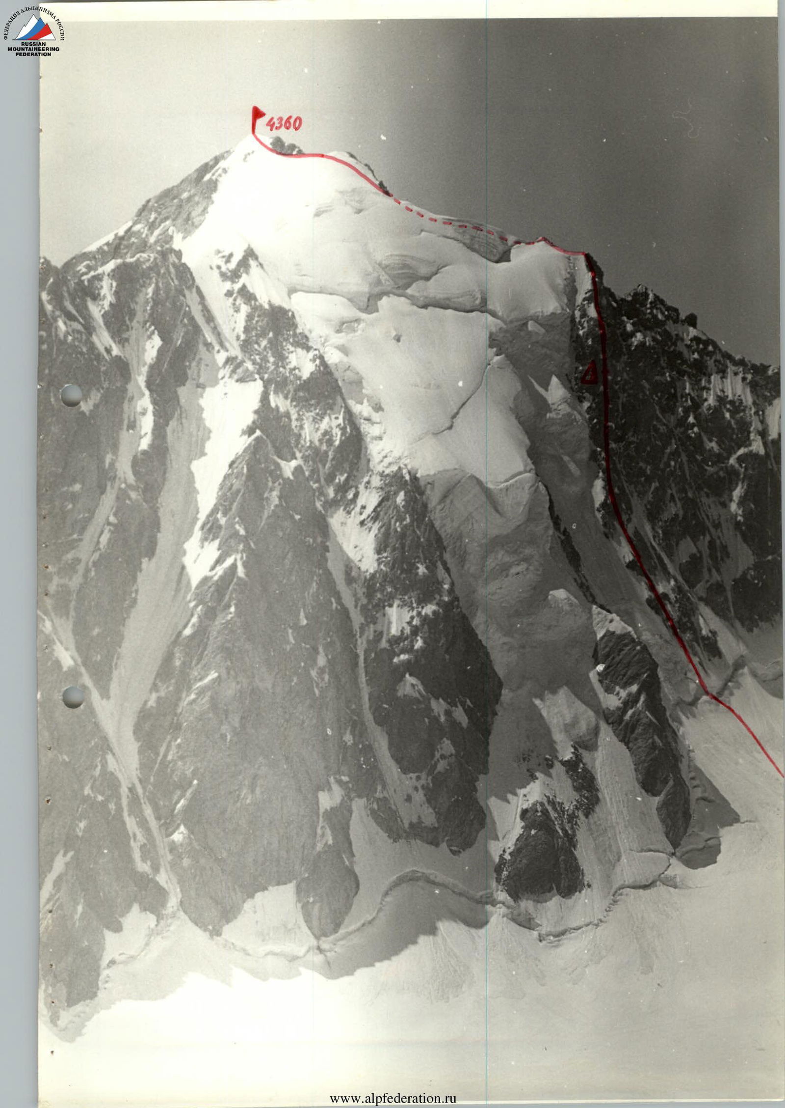
Fifth day — June 24
The bad weather persisted. There was still strong wind and wet snow, and there were still 440 m to the main ridge. Assessing the state of the route and not counting on an improvement in the weather, according to the tactical plan, we requested an extension of the control time via radio and received approval to continue working on the route.
Having overcome two rock cornices with snow drifts, we reached a steep snow ridge. In some places on the sharp, no more than 20 cm wide, ridge, cornices formed (80 m), having a cross-section in the shape of a "diamond card suit" (size 50 × 50 cm). 100 m of the ridge were traversed "on top".
Psychologically, it was extremely difficult to move along this ridge with bilateral "diamond" cornices, with feet dangling without support. One had to move upwards, but the snow was not dense enough.
In the depression, immediately behind the "triangle" peak, was the bivouac. Almost all clothing and tents were wet. To remain operational and not freeze, we dug a cave. We processed a steep snow ascent of 120 m (photo 16).
Sixth day — June 25
The main task was to reach the summit and descend to the "Torpedo" alpine camp. The weather was clear in the morning, but it was very cold. Feet and hands were freezing. At 12:00, the team reached the summit. The descent was made towards the Ronketti pass and further to the 10th branch of the Tseyskiy glacier.
Safety measures for the route included:
-
- High physical, technical, and psychological preparation of the team;
-
- A tactical plan that provided for the possibility of extending the ascent time;
-
- Material support, including the use of new equipment: titanium pitons and carabiners, nuts of various designs, ropes from Germany, down-filled equipment made from calandra, metal hammers, a metal chain, and jammers;
-
- Stable radio communication via the "Karat" radio station with the "Torpedo" alpine camp.
On the route, two hot meals and "pocket snacks" were provided. Nutrition was calculated at 350 g per person per day.
Route in UIAA symbols
- 8a —
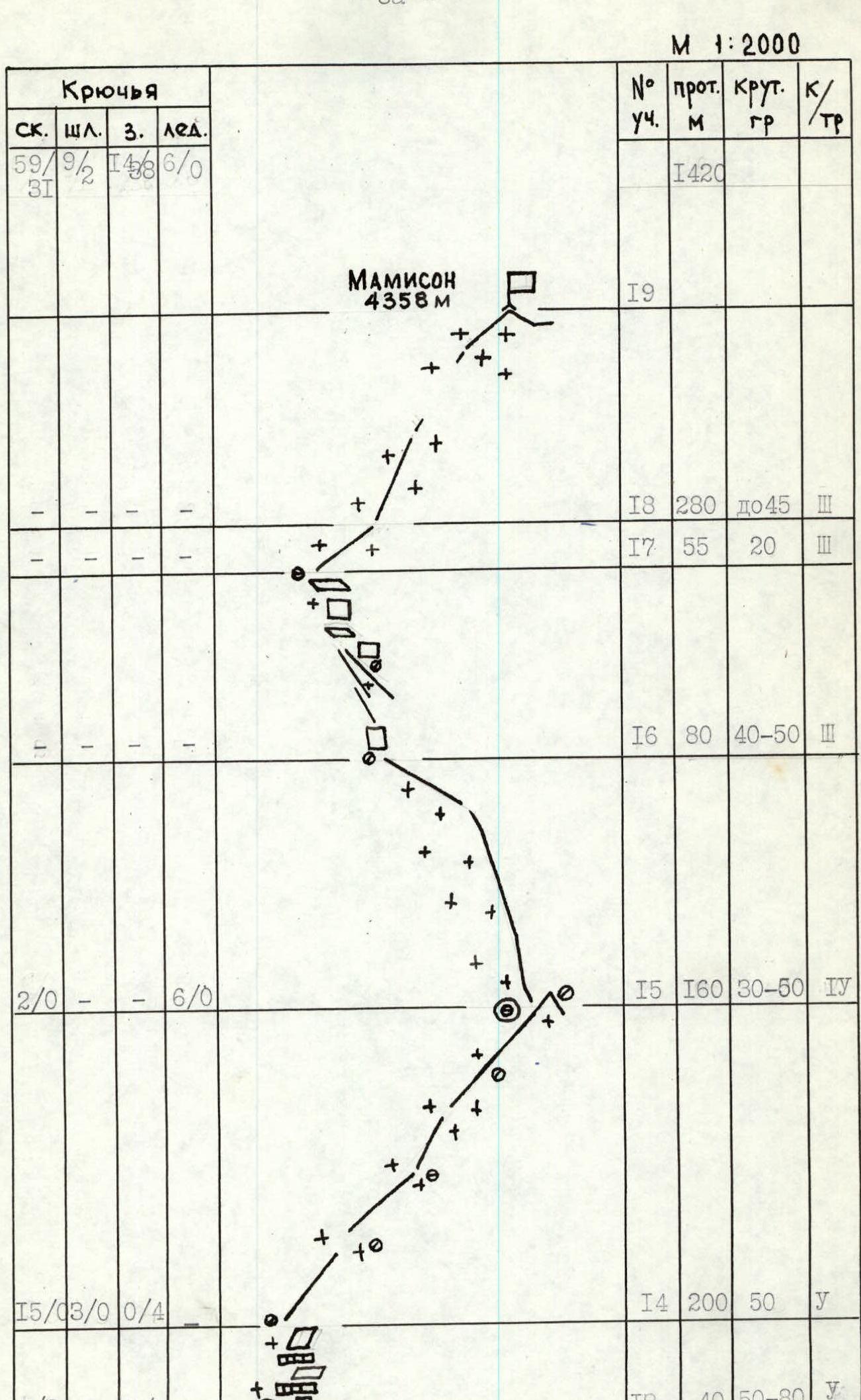
Route description by sections
Section R0–R1. The section is a snow-ice ascent, intersected by a bergschrund at the bottom, 60 m, up to 70°, 1st cat. diff. Section R1–R2. A steep inner corner-flake leading to an oblique snow shelf. 20 m, 80°, 1st cat. diff. Section R2–R3. An oblique snow-ice shelf (15 meters) turning into a vertical inner corner filled with snow. The corner is passed along the right vertical wall. Then, crossing the corner from right to left, exit to a snow drift. 35 m, 80–90°, 1st cat. diff. Section R3–R4. An overhanging inner corner passed using artificial aids. It rests against a belt of powerful cornices. A 7-meter pendulum to the right is necessary, where, under the protection of a powerful overhang, a belay station is organized, and the 1st cairn is set up. 25 m, up to 100°, 1st cat. diff. Section R4–R5. A 10-meter traverse to the right and then straight up along steep slabs with ice and snow. One has to go very carefully — many loose rocks. 40 m, 70°, 1st cat. diff. Section R5–R6. Along steep, snow- and ice-covered rocks, exit under the base of the inner corner-chimney onto an inclined slab measuring 1.5 × 1.5 m. There are no cracks. To organize reliable insurance, two bolt pitons are driven. They are later used for handrails at the bivouac. The 2nd cairn is set up here. The weather does not allow further advancement. We settle in for the night. 25 m, 80°, 1st cat. diff. Section R6–R7. The vertical slab at the base of the chimney is traversed from left to right and then ascended along a small inner corner under the protection of cornices. 15 m, 90°, 1st cat. diff. Section R7–R8. Traverse from right to left with a gain in height. Entry into the inner corner filled with snow. Straight up the corner to a small triangular slab. 35 m, 90–95°, 1st cat. diff. Section R8–R9. From the corner-chimney along the right wall, overcoming a small cornice, then along a steep inner corner, exit under the base of an 80-meter slab. The weather worsened sharply, and we had to descend to the previous bivouac. 30 m, 85–95°, 1st cat. diff. Section R9–R10. Along a vertical inner corner (20 m) exit onto a slab; cracks are filled with snow and ice. Streams of dry snow are constantly flowing down the slab. At the base of the slab — an overnight stay on a narrow ice ledge. 80 m, 70°, 1–2 cat. diff. Section R10–R11. A rock gully with a minimal number of holds, passed by free climbing on friction. 30 m, 80°, 2nd cat. diff. Section R11–R12. A series of inner corners going steeply upwards from left to right leads into a narrow couloir filled with snow. Small avalanches are constantly coming down the couloir. 50 m, 60–70°, 1st cat. diff. Section R12–R13. Along a series of inner corners alternating with walls, exit onto a snow shoulder of the left face of the "triangle". 160 m, 70°, 1st cat. diff. Section R13–R14. Exit from the shoulder onto a steep edge of the left side of the "triangle". The rocks are heavily snowed in, and much time is spent on clearing. After reaching the edge, the Kochan–Chaika pair descends to an overnight stay on the snow shoulder, where they manage to set up two tents. 40 m, 50–80°, 1st cat. diff. Section R14–R15. A steep rock edge with snow drifts. 200 m, 50°, 1st cat. diff. Section R15–R16. The Rusyaev–Odintsov pair continues working on the route. The rest dig a cave. The section represents a 120-meter steep snow ascent. After completing the section, the pair descends to an overnight stay. 160 m, 30–50°, 4th cat. diff. Section R16–R17. Heavily dissected snow-covered rocks lead under a steep snow ascent and then onto the main ridge. 80 m, 40–50°, 3rd cat. diff. Section R17–R18. Along the ridge, a 40 m traverse and then a descent to a saddle. 55 m, 20°, 3rd cat. diff. Section R18–R19. Further along the snow ridge with ascents, exit to the summit. 280 m, up to 45°, 3rd cat. diff.