Shkhara (Main), North Edge, 5B cat. dif.
The initial bivouac can be organized either
- on the "Austrian overnight stays", or
- in a snowy hollow above the ice drops adjacent to the left of the rock outcrops of the North Edge (250–300 m above the base of the edge).
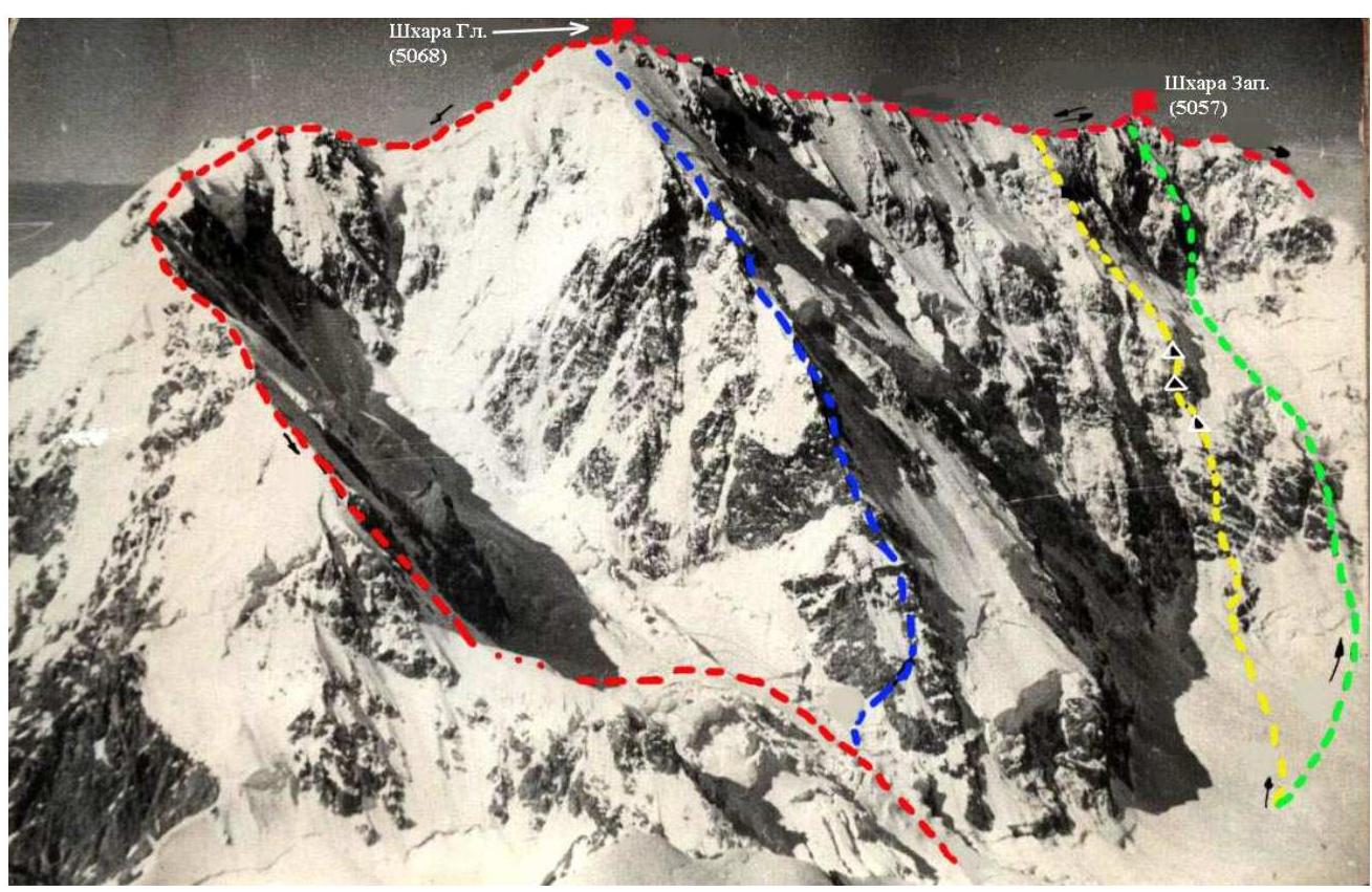
From the "Austrian overnight stays" to the snowy hollow is 2 hours according to description 7. From the hollow, having overcome the randkluft, ascend 50 m up the snowy slope to a rocky ledge going from left to right along the eastern rock wall of the North Edge. The ledge 70–80 m leads to a snow-ice couloir ("tie"), dividing the lower wide part of the edge into two ridges - kant. The couloir is stone-dangerous, and therefore, having ascended along the border of the rocks of the left ridge to the rocky island in the narrow part of the couloir, one should cross the couloir and exit to the right ridge.
Along the rocks of medium difficulty of the right ridge 150–200 m upwards under the overhanging rock wall. Here is the junction of the ridges of the lower part of the edge. Through the ice groove flowing into the couloir-"tie", exit to the 10 m wall and climb it to the overhanging rock. Further, the path goes along the clearly defined jagged ridge. Steep rocky sections and walls are bypassed on the snow on the right. After 150 m, on the left side, 3–5 m below the ridge, there is a platform for a tent. The subsequent movement goes along the snowy rocks of medium difficulty 80–100 m with an exit to the 50 m ice slope. After the rocky ascent on the gentle snow-ice ridge, resting against the wall of rusty rocks, it is possible to organize a bivouac. From the initial bivouac 10–12 hours walking.
Ascent on the left side of the inner corner up to the site and further along the chimney 6 m with an exit from it to the left along the snowy smooth slab to the gentle part of the ridge. Further 150–200 m the path goes along the rocks of medium difficulty, then another 120–150 m along the heavily destroyed rocks to the left of the ridge and another 100–120 m along the ridge to the ice couloir, bounded on the left by a sharp jagged ridge. Ascent on the left side of the couloir with an exit to the ridge on the left. 350–400 m of a strongly jagged ridge with gendarmes (straight or left) lead to a gentle snowy ridge with cornices hanging to the west. Under the rocky "finger" it is possible to organize an overnight stay. 8–12 hours from the rusty ascent. Along the snowy rocks, alternating with ice slopes, then along the ice groove, exit to the platform under the overhanging rocky wall 25–30 m from the drops of the hanging glacier. It is possible to organize an overnight stay, 4–5 hours from the rocky "finger".
From the site, ascend upwards along the icy rocky groove straight under the drop and then left upwards along the edge of the rocky wall under the drop to exit 40–45 m to its cape. Further, two variants of ascent are possible. The first is to ascend to the drop and exit to the snowy slope, where it is possible to organize an overnight stay. The second is to cross the 50–60 m couloir separating the drops from the NE buttress of the North Edge, and ascend along the snowy rocks on its left side to exit to the snowy bridge of the ridge. The ridge ends and further goes the pre-summit snow-firn slope. On the bridge it is possible to organize an overnight stay. From the bridge to the summit along the slope is 1.5–2 hours.
Descent from the summit along the NE ridge - according to description 7.