Report
On the first ascent of Peak Koshtan-Tau via the Southwest Ridge wall, done in 1971 for the USSR Championship in the category of technically complex ascents
Kuibyshev, 1971
Alpine Characteristics of the Region
The Bezengi region is the true center of the Central Caucasus. It is home to almost all of its five-thousanders (except for the extinct volcanoes Elbrus and Kazbek). The region has a very complex geological structure, was uplifted during the last Quaternary phases of the Alpine four-axle Fogenesis and is one of the most interesting regions in terms of alpinism.
The intense glaciation from the north, the steepness of the rock walls from the south, and the vast extent of possible paths from any side attract groups of qualified climbers. The climate of this region is harsh, which is explained not only by the large elevation compared to other Caucasus regions but also by the location of the surrounding ridges.
The unsettled weather here is the result of:
- the penetration of air flows from the south;
- abundant local evaporation;
- which often leads to snowfalls and thunderstorms.
Unstable weather with thunderstorms and frequent fogs requires climbers to:
- make more correct tactical decisions;
- have high moral preparation;
- excellent physical fitness;
- technical training for quick passage of the most complex sections;
- reach places suitable for organizing a bivouac.
The Koshtan-Tau massif, 5145 m high, is located in the eastern part of the so-called "northern spur of the lateral ridge" and is one of the most impressive peaks in the region of the Bezengi, Dykh-Su gorges - the highest and harshest mountain region of the Caucasus.
The massif has several accessible ridges, which can be approached through a number of gorges:
- Bezengi;
- Krumkol;
- Tjutjun;
- Dumala.
The abundance of ice, snow, and rocks varying in relief and steepness creates exceptional opportunities for climbers, and naturally, such a peak was one of the first to attract the attention of climbers at the dawn of mountaineering.
G. Woolley and Jossi first ascended to the summit of Koshtan-Tau in 1889 from the Totjun glacier.
The first Soviet ascent was made on August 25, 1933, by A. A. Maleinov and V. Solovey via the easiest northeastern ridge.
In 1938, E. Abalakov and V. Miklashevsky ascended to the summit via the western ridge during a traverse from Dykh-Tau.
In the post-war years, the following routes were first passed:
- via the eastern ridge from the Dumala gorge - by a group led by B. A. Garf in 1948;
- via the southwest rib in 1955 - by a group led by I. A. Galustov;
- via the eastern wall in 1958 - by a group led by A. F. Naumov.
With the opening of the alplager in the Bezengi gorge, the development of the massif continued, and new wall routes were passed:
- via the northeastern rib - a group led by V. Monogarov in 1961;
- in the same year, a team led by A. Simonik ascended to the summit via the northern wall.
The last wall first ascent was made by a group led by A. F. Naumov in 1962, who ascended via the southeastern rib.
Almost all these routes are classified as routes of the fifth difficulty category, and several ascents took prize places in the USSR Championship.
Routes via the northern wall of the massif have been regularly passed by groups of athletes from the Bezengi alplager and various gatherings in recent years.
At the same time, both routes from the south from the Krumkol gorge have not been repeated by anyone.
The attention of Kuibyshev climbers to the southwest rib wall declared in 1971 was drawn as early as 1966, when team members V. Benkin and V. Bochkov observed it from the peaks of Ailama and Nuam-Kuam.
It was attractive due to:
- the apparent logic of the possible route;
- its length;
- significant steepness.
It was clear that overcoming this wall was much more complicated than any other route passed on Koshtan-Tau. It was this route that the team declared as the main option.
Information about the Team
The team approved for the championship consisted of seven people: Benkin V. (captain), Bochkov V., Statsky L., Yastrebov V., Ashanin V., Kazayev Yu., and Gavrilychik V.
The team was formed over several years. Its participants from 1966 to 1971 were the core of the annually conducted gatherings and expeditions, conducted constant coaching work at home and in the mountains, and annually made joint ascents up to category 6 inclusive. The best joint ascents of recent years were: the traverse of Peak Chapdara - Peak Bodkhona with an ascent to Chapdara from the north - 5B + 1 cat. diff. and the southern wall of Peak Engels 6 cat. diff., which was passed by all team members except Ashanin in 1970.
Both routes were recognized as the best in those years at the championship of the Central Council of the DSO "Trud".
On June 23, 1971, the team, along with the entire composition of the training and educational gathering of the Kuibyshev regional council of the DSO "Trud", ascended to the Bezengi gorge and near the alplager set up a base camp. After conducting training on the rocks of Peak Brno and on the ice of the Kondon-Mezhgergi glacier, and then training ascents to Peak Uy 3B cat. diff. and to the Central peak of Dykh-Tau via the southern counterfort 5A cat. diff., a storming group of four people was approved:
- MS Benkin V. (captain);
- MS Bochkov V.;
- CMS Statsky L.;
- CMS Yastrebov V.
On July 10-12, the team prepared for the exit to the Krumkol gorge, having gathered all necessary equipment and supplies. A tactical plan for the ascent was developed, which was reviewed and approved along with the route sheet and safety measures by the Authorized Representative of the All-Union Committee for the region, MS Zak P. S.
However, on July 13, due to the unexpected illness of Benkin V., MS Gavrilychik V., who was listed in the reserve composition, was introduced into the storming group instead of him, and the functions of the captain were transferred to MS Bochkov V. These changes were approved by the Authorized Representative.
Thus, the team included Masters of Sport Bochkov V. and Gavrilychik V., who had extensive experience in passing complex wall routes (Gavrilychik, in addition to the wall of Peak Engels, participated in the assault on the North wall of Peak Revolution) and Candidates for Master of Sport Statsky L. and Yastrebov V., who grew in this team from the 2nd sports category to class athletes, mastering the entire complex of technical techniques on rock, ice, and snow slopes.
| Surname, Name | Year of Birth | Party Membership | Sports Rank | Profession | Home Address | Best Ascents |
|---|---|---|---|---|---|---|
| 1. Bochkov V. N. | 1931 | CPSU | MS | Engineer VAZ | Tolyatti, Mira 126–70 | Peak Engels via the S. wall 1970, 6 cat. diff. |
| 2. Gavrilychik V. I. | 1932 | non-party | MS | Engineer VAZ | Tolyatti, Frunze 189–46 | Peak Revolution via the N. wall 1967, 6 cat. diff., Peak Engels - 1970, 6 cat. diff. |
| 3. Yastrebov V. G. | 1937 | non-party | CMS | Construction Engineer | Kuibyshev, Sadovaya 63-a | Peak Engels, 6 cat. diff., 1970 |
| 4. Statsky L. N. | 1940 | non-party | CMS | Engineer VAZ | Tolyatti, Moskovsky pr., 114–62 | Peak Engels, 6 cat. diff., 1970 |
Simultaneously with the team, the entire composition of the gathering went out to the Krumkol gorge. The main observing and insuring group was a group consisting of 1st sports category: Shmukhin G. (leader), Pshenichnikov A., Kim T., Bebyakow A., and Ovsyannikov B.
This group was located in the storming camp throughout the entire time the team was passing the Koshtan-Tau wall. Communication with the Authorized Representative of the All-Union Committee was carried out through liaison officers - the remaining participants of the gathering.
Before exiting to the Krumkol gorge, the insurance group made the following ascents:
- Peak Archimedes - 3A cat. diff.
- Peak Eastern Dykh-Tau via the southern counterfort - 5A cat. diff.
- Peak Shkhara via the northern rib - 5B cat. diff.
Between the storming group and the observation group, there was rocket communication.
Tactical Ascent Plan
Studying the planned route during previous observations of the wall and based on available photos made it possible to divide the route into three component parts. The wall of the southwest rib, with a total length of up to 1200 m, includes the lower wall, resembling a giant isosceles triangle 550-600 m high; the upper wall about 200 m high, and a more gentle section in the form of a 45° ice slope - 240 m, dissected by a rock ridge, 150-200 m long. The third part of the route (apart from the two walls) is the ridge of the southwest rib and part of the main ridge of the massif from the beginning of the rib to the summit. Naturally, the main complexity lies in passing the lower and upper walls. The team knew that G. Chunovkin's group, who attempted to pass this wall earlier, took two full days to ascend to the middle of the lower wall, after which the group descended. Studying the lower wall, which has a number of rock bastions at its base, created the impression of two possible variants for exiting to the wall, with an ascent in both variants to the center of the wall in its upper part. To finally choose the path along the left or right part of the lower wall, an additional observation was planned and approved by the Authorized Representative for two days on site. The plan provided for passing the entire lower wall within 3 days, passing the upper wall - 1 day, ascending to the main ridge and to the summit - 1-1.5 days, and descending via the northeastern ridge - 1.5-2 days. Overcoming this route in the conditions characteristic of the region's unstable weather required the team to be highly operational, and for this, along with excellent preparation, maximally lightening the participants' backpacks within reasonable limits.
Ascent Description
July 14
At 10:00, the group in full strength along with observers left the alplager "Bezengi" and reached the "Austrian bivouac" by 16:00.
July 15-16
The group waited out bad weather.
July 17
At 6:00, they exited through the MVTO and Spartak passes to the Krumkol glacier and stopped on the Krumkol glacier moraine at 13:00. The weather worsened in the second half of the day. Visibility was lost.
July 18
The storming group in full strength exited to the upper Krumkol plateau. The Bochkov-Gavrilychik pair observed the wall from the slopes of Peak Krumkol. The Statsky-Yastrebov pair observed the wall from the plateau.
Observation goals:
- route clarification;
- determination of possible bivouac locations;
- determination of prevailing directions and locations of stonefall on the wall.
July 19
Continued observation of the wall. The pairs switched observation points. As a result of the observation, the variant along the left side of the wall (variant No. 1) was chosen. The right variant along the central part is more dangerous due to frequent stonefall and ice fall. Passing the lower and upper walls should take 4 hours of movement, and the subsequent ascent to the main ridge and summit should not be particularly difficult and take more than one day.
Possible bivouac locations were clarified.
July 20
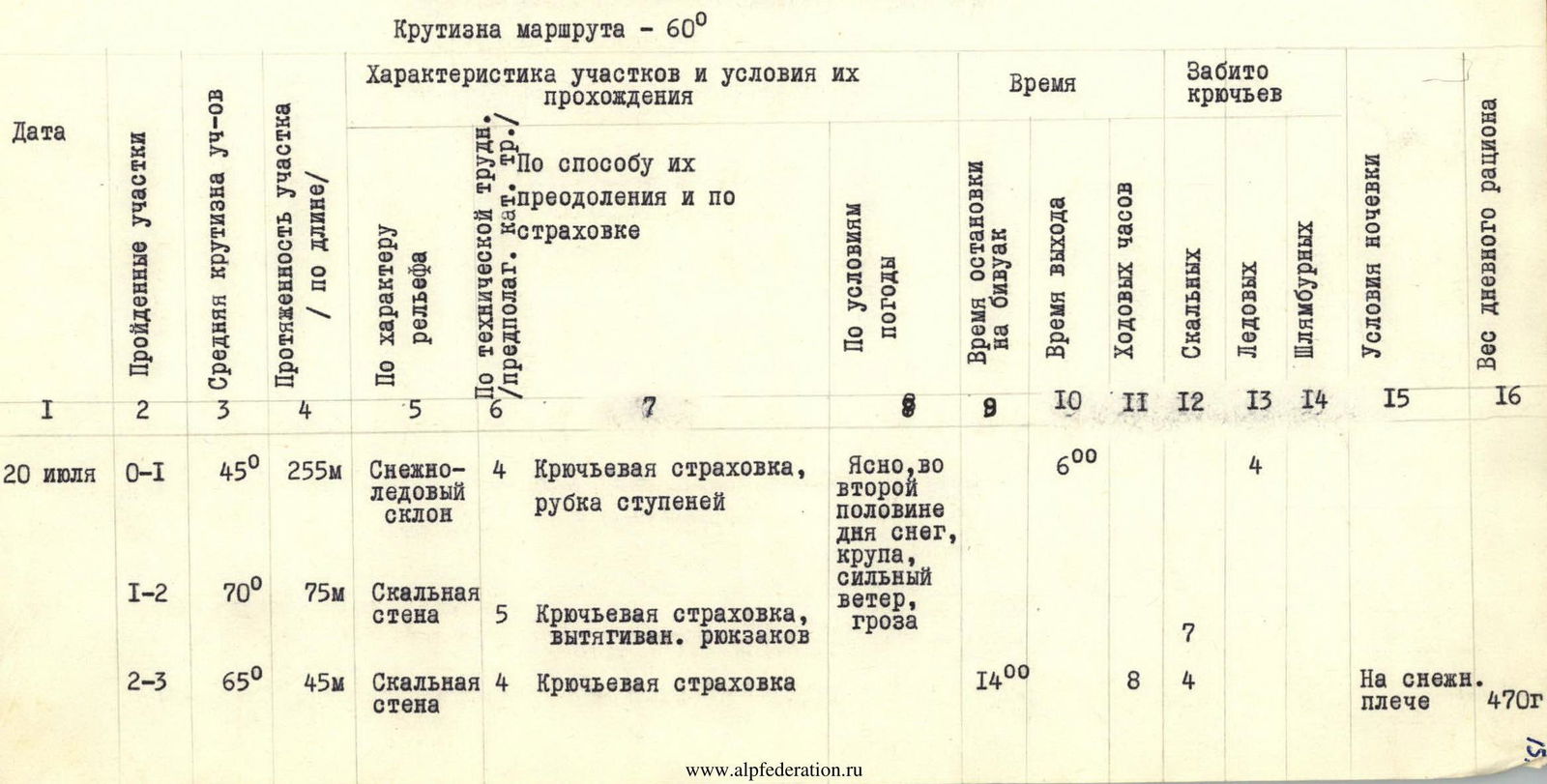
Exited at 6:00 from the night's bivouac on the upper Krumkol plateau. Passed the section R0–R1 (3400–3765 m) by 14:00. The section's height is 365 m. 11 rock and 4 ice hooks were driven.
The ascent goes along a snowy slope, overcoming the bergschrund, and along an icy slope, slightly covered with snow (section R0–R1), with hook insurance, they approach the rock wall of the left bastion. The wall is about 75 m long, with a steepness of 70° (section R1–R2). They pulled up the backpacks in two stages. Further, one rope to the left upwards (section R2–R3) leads to a snowy shoulder. Sleet, snow, and distant thunder rumble. They set up a tent. Planned processing is impossible in these conditions.
July 21
Exited at 8:00. Passed the section R1–R3 (3765–4055 m) by 21:00. The section's height is 290 m. 40 rock and 3 ice hooks were driven.
The weather is excellent, but the rocks are snow-covered, with wet underflows. Ahead is a 60-meter almost sheer rock wall (section R3–R4). The rocks are monolithic, like "Bastions," with a small number of footholds, overcome with the help of three-stage ladders. In the upper part of the wall, movement is exclusively on friction. Backpacks are pulled up with an overbound rope. This section was passed by Yastrebov in vibram shoes. Further, they ran into smooth walls, the passage of which is possible only with the help of bolt hooks. They move to the right along a narrow shelf along the wall for 60 m (section R4–R5) with the intersection of an icy couloir. The traverse is complicated, with backpacks, they are thrown off. They reach a rocky platform. They laid 1 control tour. From the platform, the path goes straight up 80 m along difficult rocks (section R5–R6). They pull up the backpacks. Further ascent straight up through the center of the wall is dangerous. From a deep vertical groove, there is a constant fall of snow, ice, and stones. They deviate to the left upwards along a steep snowy-icy slope (section R6–R7). In the upper part, they cut steps. They reach under a 30-meter rock wall (section R7–R8). The rocks are complex but have good footholds. Further, along a very steep - 65° - icy couloir for 20 m.
July 22
(section R8–R9) and sheer iced rocks (60 m, 80°, section R9–R10, climbing is difficult, they use ladders), they exit to the ridge, resting against a wall. They cut out a platform.
Processing of the wall. The section R10–R12 was processed. The height is 120 m. 28 rock and 1 bolt hook were driven.
At 8:00, the Statsky-Yastrebov pair exited to process the wall. Ahead is more than 100 m of sheer rocks, местами with negation. This is one of the key points of the route. There is no hope to pass in one day. They decide to process the wall.
From the bivouac, along a shelf, they traverse to the left for 5 m and then 80 m (section R10–R11) along smoothed rocks with a small number of footholds, they exit to a shelf under a 30-meter wall with overhanging rocks (section R11–R12).
Movement begins along an inclined shelf, iced over, to the left upwards. Further, an overhanging slab, which is passed with the help of ladders and a platform. Here, an expanding hook is driven. This is one of the most complex places on the route.
The wall leads under a huge overhanging "bald head." The further path is by traversing to the right for 15 m, leading under a 30-meter wall.
8 hours were spent on processing. The mood was spoiled: during the processing of the wall, the group's only camera was lost.
July 23
Exited at 6:00. Passed the section R12–R15 (4055–4625 m) by 19:00. The height is 570 m. 9 rock and 4 ice hooks were driven.
They passed the section processed yesterday to the last 30-meter wall. Backpacks were pulled up. Along the wall (section R12–R13) straight up. The character of the rocks is blocky. The rocks are destroyed. It's dangerous. There are several convenient ledges on the section. The lower wall is passed.
Further, along a snowy-icy slope 45–50° (section R13–R14) - and along a rocky ridge (section R14–R15) with alternate insurance, they exit under the upper wall.
They cut out a platform for a tent.
July 24
Exited at 7:00. Passed the section R15–R19 (4625–4925 m) by 20:00. The height is 300 m. 32 rock, 2 ice, and 1 bolt hook were driven.
The path goes to the left of a characteristic rock crevice filled with ice. 40 m of difficult iced rocks with a small number of footholds (section R15–R16) and along a shelf, they traverse 5 m to the right-upwards with the intersection of a black crevice under a smooth 10-meter slab with a crack (section R16–R17). Further along smoothed rocks - 30 m (section R17–R18), which they passed with the use of a ladder, they exit to a shelf. Here is the 2nd control tour. From the platform, the path goes straight up along the left edge, indicated by the characteristic crevice above, having vertical smooth walls. A "podsadka" is necessary. A platform is hung, and a bolt hook is driven. The rocks are very difficult. The length of the section is 80 m with a steepness of 85–90° (section R18–R19). They pull up the backpacks. The upper wall is passed. Along a snowy-icy slope 35 m (section R19–R20), they exit to the ridge. They move along rocks of medium difficulty (section R20–R21) and along a sharp snowy ridge (section R21–R22), they exit to a snowy plateau. They set up a bivouac.
July 25
Exited at 7:00. Passed the section R22–Peak (4925–5145 m) by 12:00. The height of the section is 220 m. 5 ice hooks were driven.
At first, they move along a snowy slope (section R22–R23), turning into a steep - 65° - icy section R23–R24, which they pass with thorough hook insurance (5 hooks), cutting steps. Further along a snowy slope (section R24–R25), they exit to a pre-summit plateau. To the left along a snowy ridge (section R25–R26), they reach the summit of Koshtan-Tau at 12:00. At 12:15, they began descending from the summit along the northeastern ridge according to the 4th cat. diff. route. They bivouacked before the "bird."
July 26
Exited at 7:00. Descended to the Kondon-Miжирги glacier and further through the broken glacier and along the Kondon-Miжирги gorge, they returned to the "Bezengi" camp.
Conclusion
The new route passed by the group on Koshtan-Tau via the southwest rib wall is complex, combined, and mostly rock. The route took 60 hours of intense work on the ascent, using the entire complex of free climbing techniques. The exceptional complexity of individual places forced the use of artificial support points to pass them. Only in two overhanging places, due to the lack of cracks and footholds, the group was forced to use bolt hooks. In terms of length and complexity of the most difficult sections, the route is not inferior to the southern wall of Peak Engels (V. Romanov's route). I. A. Galustov's route on Koshtan-Tau via the southwest rib, completely bypassing the wall, is classified as a 6B cat. diff. route.
The team's trainer throughout the entire preparatory period was USSR Master of Sport D. V. Kazayev, who conducted general physical training (cross-country running, skiing, slalom) and practiced technical techniques on the rocks of the Zhiguli Mountains.
General physical training included:
- cross-country training;
- skiing;
- slalom.
The functions of a mountain trainer, route selection, organizational and tactical plan, and technique practice during training ascents were carried out by USSR Master of Sport V. S. Benkin, who was listed as captain but could not participate in the ascent due to illness.
The team cannot provide photos of individual sections and methods of overcoming them due to the loss of the camera during the processing of the upper part of the lower wall (on section R11–R12).
Team Captain - USSR Master of Sport V. BOCHKOV
| Date | Passed Sections | Average Steepness of Sections | Section Length / by Length / | By Relief Character | By Technical Difficulty, Kc. Tr. / предполагат. | By Method of Overcoming and Insurance | By Weather Conditions | Time of Bivouac Stop | Time of Exit | Movement Hours | Driven Hooks | Bivouac Conditions | Daily Ration Weight | ||
|---|---|---|---|---|---|---|---|---|---|---|---|---|---|---|---|
| Rock | Ice | Bolt | |||||||||||||
| July 20 | R0–R1 | 45° | 255 m | Snowy-icy slope | 4 | Hook insurance, step cutting | Clear, snow, sleet, strong wind, thunderstorm in the second half of the day | 6:00 | 4 | ||||||
| R1–R2 | 70° | 75 m | Rock wall | 5 | Hook insurance, backpack pulling | 7 | |||||||||
| R2–R3 | 65° | 45 m | Rock wall | 4 | Hook insurance | 14:00 | 8 | 4 | On a snowy shoulder | 470 g. | |||||
| July 21 | R3–R4 | 80° | 60 m | Rock wall | 6 | Hook insurance, ladder, backpack pulling | Clear, snow, sleet in the second half of the day | 8:00 | 11 | 470 g. | |||||
| R4–R5 | 60 m | Traverse along the wall | 5 | Hook insurance | 7 | ||||||||||
| R5–R6 | 75° | 80 m | Rock wall | 6 | Hook insurance, ladder, backpack pulling | 10 | |||||||||
| R6–R7 | 50° | 50 m | Snowy-icy slope | 4 | Hook insurance | 1 | |||||||||
| R7–R8 | 70° | 30 m | Rock wall | 5 | Hook insurance | 4 | |||||||||
| R8–R9 | 65° | 20 m | Icy couloir | 5 | Hook insurance, step cutting | 2 | Under the wall on the ridge | ||||||||
| R9–R10 | 80° | 60 m | Rock wall | 6 | Hook insurance, ladder, backpack pulling | 21:00 | 13 | 8 | |||||||
| July 22 | R10–R11 | 75° | 80 m | Rock wall | 6 | Hook insurance, ladder | Clear | 8:00 | 8 | 16 | Same as before | 470 g. | |||
| R11–R12 | 90–95° | 30 m | Rock wall | 6 | Hook insurance, ladder, platform | 12 | 1 | ||||||||
| July 23 | R12–R13 | 85° | 30 m | Rock wall | 6 | Hook insurance | Clear | 6:00 | 5 | ||||||
| R13–R14 | 45° | 300 m | Snowy-icy slope | 4 | Hook insurance, step cutting | 4 | |||||||||
| R14–R15 | 55–60° | 270 m | Rocky ridge | 4 | Hook insurance and alternate insurance through ledges | 19:00 | 13 | 4 | Under the upper wall on the ridge | 470 g. | |||||
| July 24 | R15–R16 | 75° | 40 m | Rock wall | 6 | Hook insurance, ladder, backpack pulling | Clear | 7:00 | 6 | ||||||
| R16–R17 | 85° | 10 m | Rock wall | 6 | Hook insurance, ladder | 4 | |||||||||
| R17–R18 | 80° | 30 m | Rock wall | 6 | Hook insurance, ladder, backpack pulling | 6 | |||||||||
| R18–R19 | 85–90° | 80 m | Rock wall | 6 | Hook insurance, ladder, platform, backpack pulling | 14 | 1 | ||||||||
| R19–R20 | 50° | 35 m | Snowy-icy slope | 3 | Hook insurance, step cutting | 2 | |||||||||
| R20–R21 | 60° | 45 m | Rocky ridge | 4 | Hook insurance | 2 | |||||||||
| R21–R22 | 40° | 120 m | Snowy ridge | 3 | Simultaneously, ice axe | 20:00 | 13 | On a snowy plateau | 470 g. | ||||||
| July 25 | R22–R23 | 40° | 70 m | Snowy slope | 3 | Simultaneously, ice axe | Clear | 7:00 | |||||||
| R23–R24 | 65° | 80 m | Icy slope | 4 | Hook insurance, step cutting | 5 | |||||||||
| R24–R25 | 40° | 70 m | Snowy slope | 3 | Simultaneously, ice axe | 12:00 - summit | |||||||||
| TEAM CAPTAIN | |||||||||||||||
| MASTER OF SPORT USSR | |||||||||||||||
| (V. BOCHKOV) |
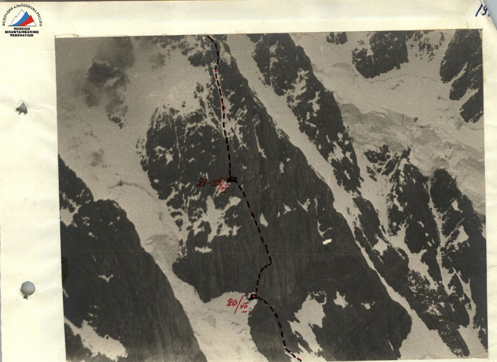 Lower wall. Sections R1–R14. (Taken from the southern ridge of the Krumkol massif).
 Fig. 1. Section R3–R4.
Conventional signs:
Fig. 1. Section R3–R4.
Conventional signs:
- Rock self-insurance hook
- Rock hook
- Titanium wedge
- Backpack pull-out point
 Fig. 3. Passage of sections R15–R16–R17–R18–R19 (upper wall). Path of passage.
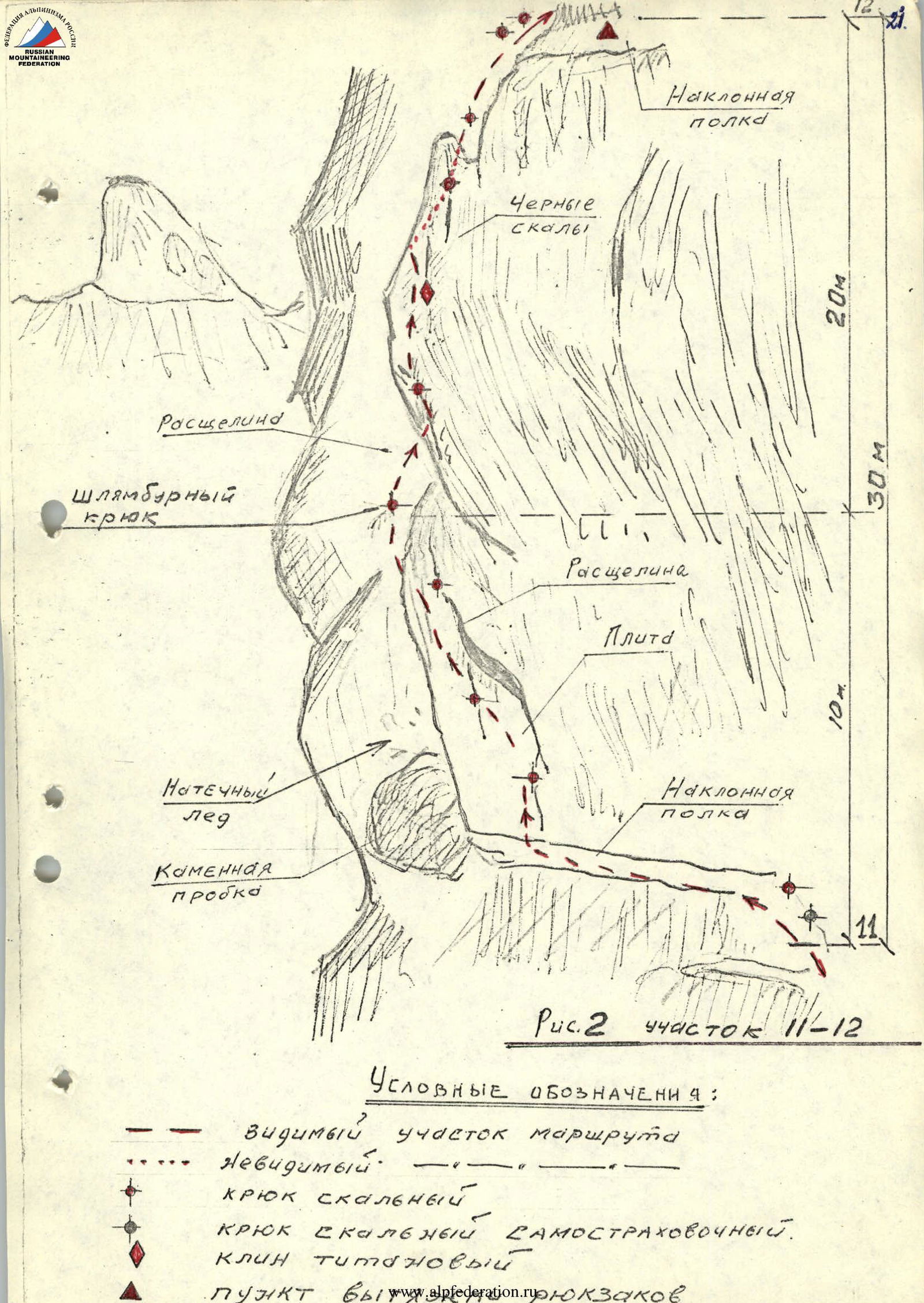
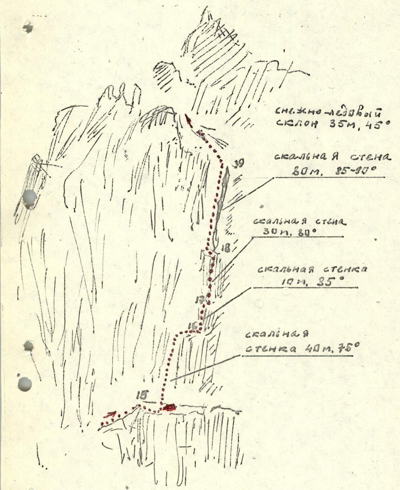 Fig. 2. Section R11–R12.
Conventional signs:
Fig. 2. Section R11–R12.
Conventional signs:
- Visible section of the route
- Invisible
- Rock hook
- Rock self-insurance hook
- Titanium wedge
- Backpack pull-out point