Moscow Climbing Championship 2024
High-Altitude Technical Class
Report
On the ascent to the summit of Karakaya via the Central Counterfort of the Southwest Wall, 6A category of difficulty, by the team from Moscow from October 9 to October 13, 2024.

Semenov M. A. — Master of Sports Vvedenskaya V. V. — 1st sports category Spichka A. I. — Candidate for Master of Sports Alpine Club — "Mountain Madness" 2024
I. Ascent Passport
| 1. General Information | ||
|---|---|---|
| 1.1 | Full name, sports category of the leader | Semyonov Mikhail Alexandrovich, Master of Sports |
| 1.2 | Full name, sports category of participants | Spichka Andrian Ivanovich, Candidate for Master of Sports, Vvedenskaya Varvara Vyacheslavovna, 1st sports category |
| 1.3 | Full name of the coach | Sitnik Mikhail Alexandrovich, Shipilov Vyacheslav Alexandrovich |
| 1.4 | Organization | Moscow Alpine Federation |
| 2. Characteristics of the ascent object | ||
| 2.1 | Region | Caucasus |
| 2.2 | Gorge | Bezengi Gorge |
| 2.3 | Number of the section according to the 2013 classification table | 2.5.226 |
| 2.4 | Name and height of the summit | Karakaya Central 3646 m |
| 2.5 | Geographical coordinates of the summit (latitude/longitude), GPS coordinates | 43°16′01″ N 43°14′47″ E |
| 3. Characteristics of the route | ||
| 3.1 | Name of the route | Via the Central Counterfort of the SW wall (E. Poltavets, 2010) |
| 3.2 | Proposed category of difficulty | 6A |
| 3.3 | Degree of route exploration | Explored |
| 3.4 | Nature of the route terrain | Rock |
| 3.5 | Height difference of the route (altimeter or GPS data) | 712 m |
| 3.6 | Route length (in meters) | 1010 m |
| 3.7 | Technical elements of the route (total length of sections of varying difficulty with terrain type indication (ice-snow, rock)) | 2–3+ rock category — 320 m. 4 rock category — 175 m. 5 rock category — 250 m. 6 rock category — 125 m. |
| 3.8 | Average slope of the route, (°) | ~68° |
| 3.9 | Average slope of the main part of the route, (°) | First bastion ~76°, Second bastion ~81°, Third bastion ~87° |
| 3.10 | Descent from the summit | Rappelling down from the control cairn 100 m west of the saddle between Karakaya Central and Karakaya West. |
| --- | --- | --- |
| 3.11 | Additional characteristics of the route | Then on foot along the couloir to the trail. |
| Logistics are convenient; the approach from the road along gentle slopes takes 2–3 hours with a load, and there are safe and convenient overnight stays near the wall. There is no water on the route; it can be collected from a stream on the approach to the wall. The route is quite "crumbly," especially the 2nd and 3rd bastions. There is almost complete cell phone coverage with "Megafon" throughout the route. | ||
| 4. Characteristics of the team's actions | ||
| 4.1 | Time in motion (team's walking hours, in hours and days) | 29 hours, 5 days |
| 4.2 | Overnight stays | 1, 2 — on the summit of the first bastion on a platform; 3 — on the summit of the second bastion on a platform |
| 4.3 | Time spent processing the route | 12 hours |
| 9:00 — 4 hours | ||
| 11:00 — 6 hours | ||
| 12:00 — 2 hours | ||
| 4.4 | Start of the route | 13:10 on October 9, 2024 |
| 4.5 | Reaching the summit | 14:00 on October 13, 2024 |
| 4.6 | Return to the base camp | 17:30 on October 13, 2024 |
| 5. Characteristics of weather conditions | ||
| 5.1 | Temperature, °C | from 0 to +15 |
| 5.2 | Wind speed, m/s | |
| 5.3 | Precipitation | |
| 5.4 | Visibility, m | |
| 6. Person responsible for the report | ||
| 6.1 | Full name, e-mail | Vvedenskaya Varvara Vyacheslavovna, varya.vvedenskaya@gmail.com |
II. Ascent Description
1. Characteristics of the Ascent Object
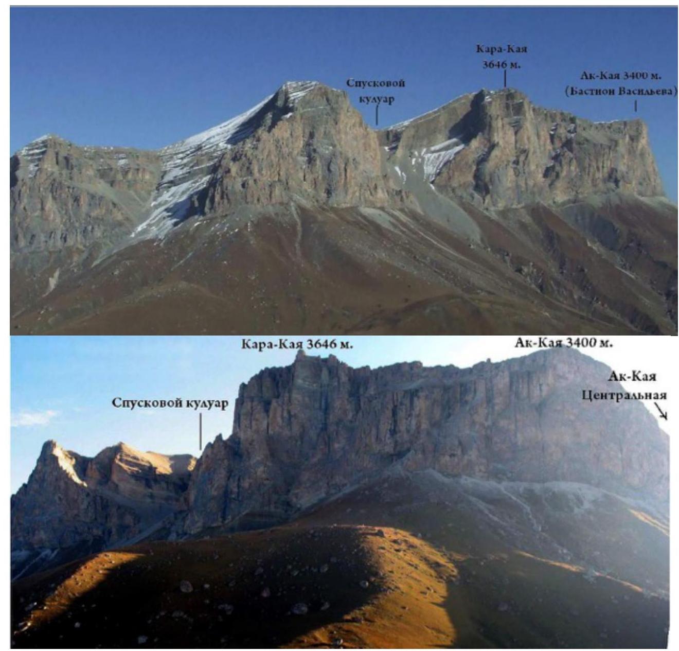
1.1. General Photo of the Summit
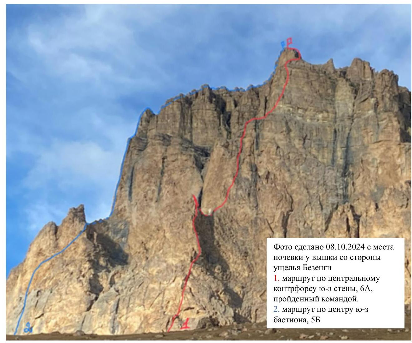 Photo taken on October 8, 2024, from the overnight stay site near the cell tower on the side of the Bezengi gorge: 1. the route along the central counterfort of the SW wall, 6A, climbed by the team; 2. the route along the center of the SW bastion, 5B.
1.2. Photo of the Route's Starting Profile
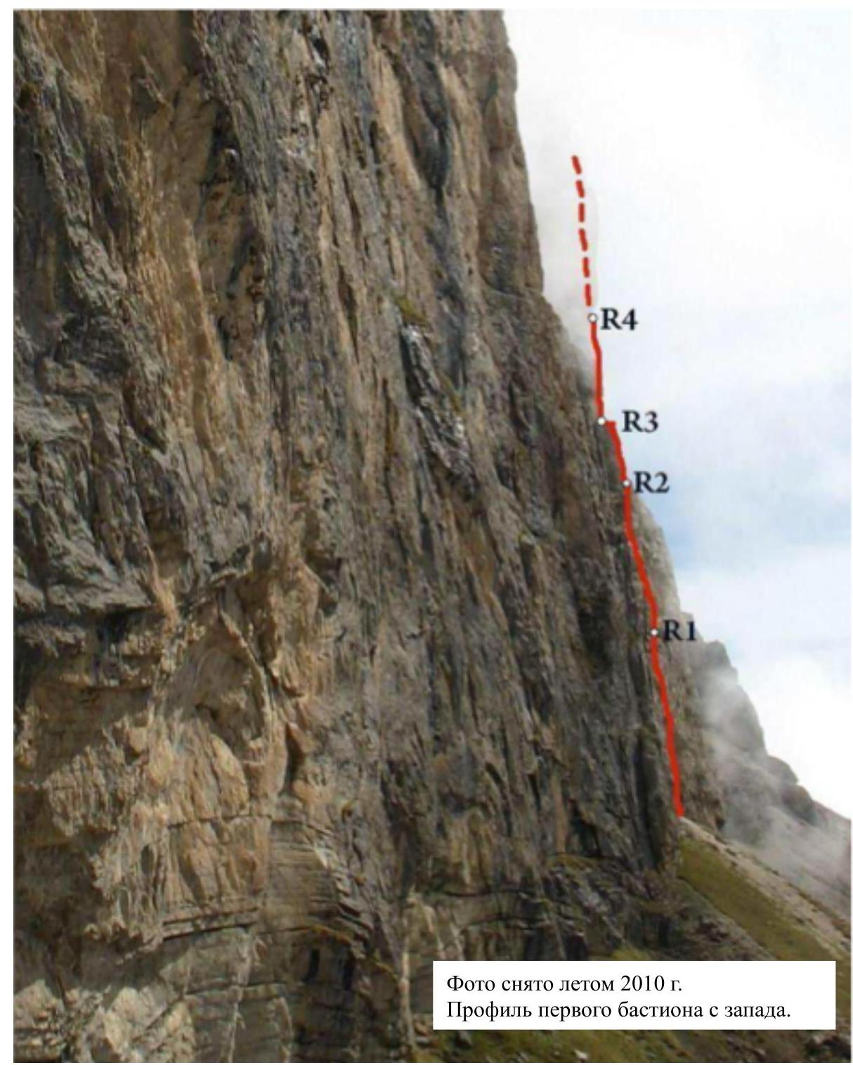
 Photo taken in the summer of 2010. Profile of the first bastion from the west.
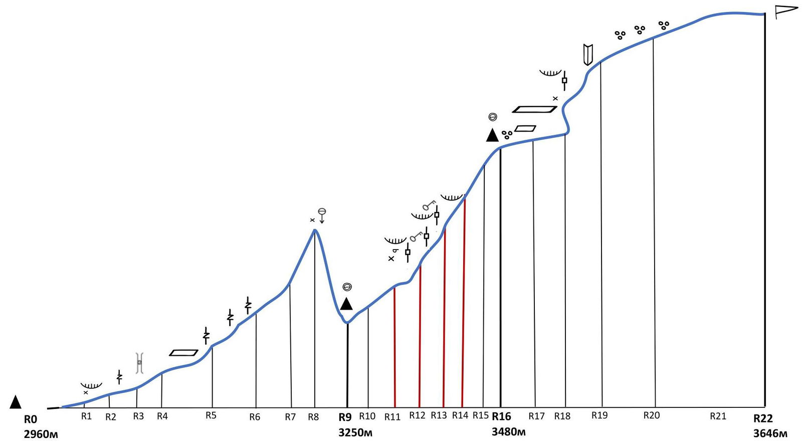
1.3. Drawn Profile of the Route
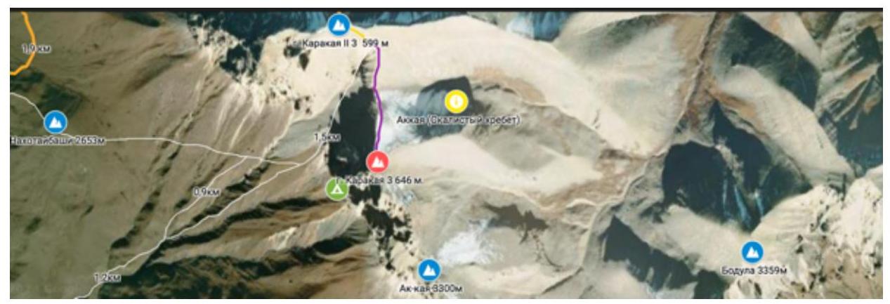
1.4. Panoramic Photo of the Area
1.5. Area Map, Ascent Object Map
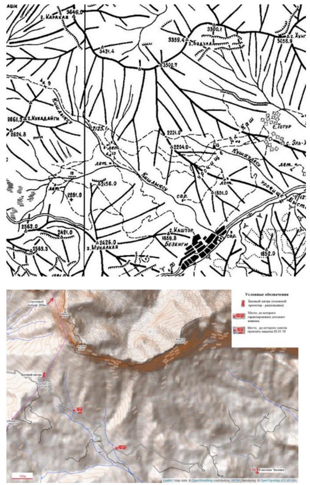
Geographical Location, Features, Remoteness, Approach Paths
The Karakaya summit is located in the Rocky Range of the Caucasus between the Chegem River to the west and the Cherek-Khulamsky River to the east. The Rocky Range is parallel to the Main Caucasian Range. The mountain is part of the vast Ak-kaya massif and is its highest point and the highest peak of the range.
In this area, the Rocky Range forms a horseshoe-shaped massif. Karakaya is located in the western part of this massif. Karakaya West has a pronounced peak.
The Dumala pass (2515 m) can be reached by car from either the Chegem or Bezengi gorges.
We ascended from the Bezengi gorge. From the village of Bezengi, a dirt road (about 12 km) leads to the pass, connecting neighboring gorges.
The approach under the southwest wall is technically simple and takes about 2 hours; a distinguishable trail is present in some areas.
The area is suitable for climbing year-round. From November to May, the weather is unstable, but there are occasional weather windows.
2. Characteristics of the Route
2.1. Technical Photo of the Route

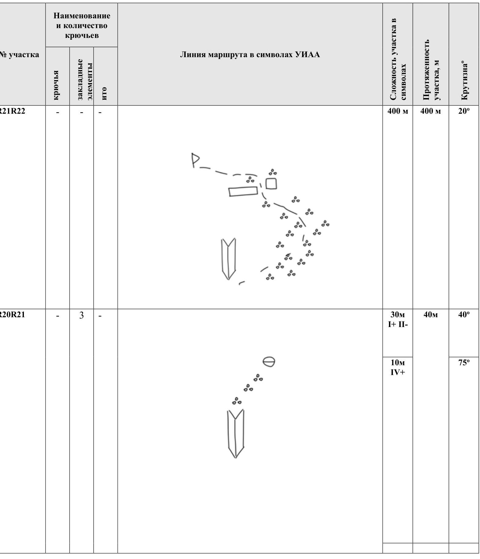
2.2. Route Diagram in UIAA Symbols
| Section # | Pitsons | Nuts | ITO | Difficulty | Length, m | Slope, ° |
|---|---|---|---|---|---|---|
| R21–R22 | - | - | - | 1+–2- | 400 | 20 |
| R20–R21 | - | 3 | - | 1+–2-, 4+ | 40 | 40, 75 |
| R19–R20 | 8 | 10 | 3 | 4, 5+ A2 | 50 | 60, 90 |
| R18–R19 | 3 | 6 | - | 4+, 5-, 4 | 30 | 80, 70, 80 |
| R17–R18 | 9 | 8 | 2 | 5+ A1, 5+ | 50 | 90 |
| R16–R17 | - | - | - | 1+ | 70 | 30 |
| R15–R16 | 3 | 7 | - | 1+–2-, 5+, 4- | 60 | 30, 75, 60 |
| R14–R15 | 4 | 4 | - | 4- | 50 | 70 |
| R13–R14 | 7 | 8 | 4 | 6 A3, 5 | 60 | 90 |
| R12–R13 | 10 | 3 | 3 | 6 A2, 6 | 50 | 90 |
| R11–R12 | 6 | 5 | 3 | 6 A2, 5+ | 50 | 90, 85 |
| R10–R11 | 8 | 5 | 3 | 6 A2, 5+ | 50 | 90 |
| R9–R10 | - | - | - | 3+, 2+ | 120 | 60, 30 |
| R7–R8–R9 | 5 | 7 | - | 6-, 5+, 3+ | 60 | 70, 40 |
| R6–R7 | 6 | 10 | - | 4+ | 60 | 90, 60, 80 |
| R5–R6 | 2 | 10 | - | 5, 4 | 55 | 75, 80 |
| R4–R5 | - | - | - | 1+–2 | 40 | 20 |
| R3–R4 | - | 9 | - | 4+, 5-, 5- | 50 | 90, 85, 90 |
| R2–R3 | 4 | 7 | - | 4+, 5 | 50 | 80 |
| R1–R2 | 5 | 9 | - | 3, 4, 5, 3 | 50 | 60, 90, 75 |
| R0–R1 | 3 | 8 | 2 | 4, 5, 5+ A1, 3 | 50 | 80, 90, 70 |
3. Characteristics of the Team's Actions
3.1. Brief Description of the Route Passage
The route was chosen due to the late season. Many other areas had already ended their climbing season. In the fall, this part of the Rocky Range can experience weather windows. Additionally, the route has simple logistics and is well-trodden. Previous climbers described the route as having convenient platforms for overnight stays.
Also:
- Two team members had unresolved issues with this route — Spichka A.I. and Semyonov M.A. had attempted it in 2022.
- For Vvedenskaya V.V., this was the first 6A category route in the high mountains.
- Team members were familiar with each other and had previous climbing experience together.
- They planned to climb together this season.
Before the ascent, they carefully selected the necessary equipment. They brought:
- 3 static ropes and 1 dynamic rope
- 1 set of cams
- 1 set of Totems
- 1 set of nuts
- 15 pitons (including two Givi pitons — recommended to have three such pitons due to many cavities they fit into perfectly)
- 26 quickdraws
For the ascent, they took:
- a double-layer, two-person tent weighing 900 g
- two down sleeping bags
- one down blanket
- half a sleeping pad
- one full sleeping pad
They used a three-person Forclaz tent as the base tent. They had a considerable amount of gear and decided to bring a haul bag and two backpacks.
October 8, 2024
The team met in Mineralnye Vody, gathered their equipment, and drove to the area. They ascended to the pass in their SUV, set up camp near the cell tower, and spent the night.
Since there might not be water or snow on the route at this time of year, they decided to carry 18 liters of water, calculated as 5 liters per 3 people per day plus a reserve. They collected water from a stream on the approach to the wall.
October 9, 2024
After resting and having breakfast, they distributed the load and set out under the wall at 9:30. They arrived at the overnight stay site under the wall at 11:30, set up camp, and sorted their equipment. At 12:40, Spichka A.I. and Vvedenskaya V.V. began under the start of the route. Semyonov M.A. made one trip to the car for gear, fetched water for the ascent, and stored a reserve in the base camp for their return. At 13:00, Vvedenskaya and Spichka started processing the route. The start of the route has an alternative option to bypass to the left via a simpler internal corner; however, this makes the entire rope "lawn" (easier climbing) and lengthens the awkward traverse to the right. They chose the option described in the first ascenders' report. At 17:30, they began descending, processing 2+ ropes.
The rest of the ascent was done in tandem. Semyonov M.A. led, Vvedenskaya V.V. provided belay and managed hauling the haul bag, and Spichka A.I. followed and assisted with hauling.
October 10, 2024
The team set out under the route at 5:50, began jumar-ing at 6:00, and continued up the route at 7:30. They moved relatively quickly this day, spending a lot of time and energy on hauling the load until they optimized their logistics and interaction.
One of the most challenging sections for hauling was the chimney on R3–R4, as they hauled directly through it. "Recommendation: after passing the chimney, re-route the rope outside the chimney." They hauled the haul bag into the chimney together, under the plug. There's a piton at the base of the chimney; it's visible only when you're inside; their setup was on a large flake. At the end of R4, there's a platform suitable for an overnight stay. The entire section was climbed without IT (artificial techniques) this day; after the chimney, when bypassing an overhang, there was a desire to use IT, but it required some thought. They set up camp on the summit of the first bastion at 16:00 for the first overnight stay.
October 11, 2024
The weather deteriorated at night with strong gusts of wind and snow. By 6:00, the weather hadn't improved, so they decided to wait it out, questioning their further movement.
At 8:00, in poor weather conditions, they exited to inspect the next section and attempted to climb further but returned to the tent at 9:00 to rest and have tea.
By 12:00, the weather began to stabilize. They started processing the route at 12:00 (Semyonov — Vvedenskaya). They decided not to move the camp and return to it after processing.
Climbing in this section was complex and tense, with movement partly on IT. Two of the three ropes processed that day can be considered key sections of the route.
They began descending to the camp in the evening twilight at 18:00. They processed 3 ropes according to their description and 4 sections according to the first ascenders' description. To facilitate hauling the haul bag, they straightened all sections vertically down. Two ropes were sufficient, considering the sleeping pads and an additional ascent to a large ledge. Two ropes remained unused. They descended directly to a platform 8–10 m below the first significant large ledge, about 20 m in a straight line. The belay for the route was set from a smaller ledge above, directly under the cornice. On the large ledge, they left a spare cord for rappelling the last participant with the haul bag. On the ledge above, from which they belayed during the passage, there was already a local loop (likely also for exiting the pendulum). All team members were back in the tent by 18:30.
October 12, 2024
A strong wind blew throughout the night. By morning, the weather had stabilized, and precipitation ceased.
They began jumar-ing at 8:00, and the first participant continued up the route at 10:50.
The second bastion was more challenging than the first. They reached the overnight stay on the summit of the second bastion at 15:30. The ledges were quite crumbly, but the platform for the tent was convenient and safe. There was some snow, but not enough for cooking. They worked on the platform, set up camp, and began processing at 16:50 (Semyonov — Spichka). The transition to the start of the third bastion was a pedestrian traverse along scree. The start of the third bastion consists of blocks with narrow scree ledges transitioning into vertical walls with internal corners and cornices. They processed 1 rope and finished at 17:50 (R22 according to the first ascenders' description — the spot where a piton is driven very low). They returned to the tent at 18:30.
October 13, 2024
They began jumar-ing at 7:35 and continued at 8:20. In this part of the route, they spent a lot of time finding the correct line. The description was unclear. Eventually, they found the desired piton, located to the right of the lower part of the "patch" (a large awkward flake) on R23 according to the first ascenders (R20 according to their count).
The challenging climbing ends on R24 (according to the first ascenders; R20 according to their count). Then, a short wall leads to scree "gardens," followed by another step, and then a right turn along a ledge, bypassing two internal corners (section R25–R26 in the first ascenders' description) — there's no need to climb there; it's all bypassed on simple scree. Then, they continued on similar scree to the summit. The team reached the summit at 14:00 and left a note.
They retrieved a note from the St. Petersburg Federation team dated August 3, 2024. They spent 25 minutes on the summit, proceeded to the second peak, and retrieved a note from the Ukrainian Alpine Federation and "Odessa" Alpine Club team dated February 25, 2012, on a 5B category route.
Control cairns were established on both peaks, possibly in error.
At 14:45, they headed towards the descent couloir. From the summit, they moved along the edge of the wall towards Karakaya West to a characteristic saddle. They went 100 m beyond the saddle towards the Western peak to a cairn.
They started rappelling from a large flake at 15:00, which has loops for descent. The descent involved three rappels: two at the beginning down rocky slopes into the couloir, where there are many hanging live rocks, and the final one at the exit from the couloir onto scree. Most of the descent was on foot, overcoming short walls, with some sections having water flowing down them, and with loops and pitons in place. They exited the couloir onto scree slopes at 17:00, where a trail was somewhat distinguishable, and reached the base tent under the wall at 17:30.
| Section # | | R5–R6 | 2 | 10 | — | | 25 m V | 55 m | 75° | | | | | | | | 30 m IV | | 80° | | | | | | | | | | | | R4–R5 | — | — | — | | | 40 m I+–2 | 40 m | 20° | | R3–R4 | — | 9 | | | | 10 m 4+ | 50 m | 90° | | | | | | | | 15 m 5- | | 85° | | | | | | | | 25 m 5- | | 90° | | R2–R3 | 4 | 7 | — | | | 30 m 4+ | 50 m | 80° | | | | | | | | 20 m 5 | | | | R1–R2 | 5 | 9 | — | | | 10 m 3 | 50 m | 60° | | | | | | | | 10 m 4 | | 90° | | | | | | | | 20 m 5 | | | | | | | | | | 10 m 3 | | 75° | | R0–R1 | 3 | 8 | 2 | | | 5 m 4 | 50 m | 80° | | | | | | | | 20 m 5 | | | | | | | | | | 15 m 5+ A1 | | 90° | | | | | | | | 10 m 3 | | 70° |
3. Characteristics of the Team's Actions
3.1. Brief Description of the Route Passage
The route was chosen due to the late season. Many other areas had already ended their climbing season. In the fall, this part of the Rocky Range can experience weather windows. Additionally, the route has simple logistics and is well-trodden. Previous climbers described the route as having convenient platforms for overnight stays.
Also:
- Two team members had unresolved issues with this route — Spichka A.I. and Semyonov M.A. had attempted it in 2022.
- For Vvedenskaya V.V., this was the first 6A category route in the high mountains.
- Team members were familiar with each other and had previous climbing experience together.
- They planned to climb together this season.
Before the ascent, they carefully selected the necessary equipment. They brought:
- 3 static ropes and 1 dynamic rope
- 1 set of cams
- 1 set of Totems
- 1 set of nuts
- 15 pitons (including two Givi pitons — recommended to have three such pitons due to many cavities they fit into perfectly)
- 26 quickdraws
For the ascent, they took:
- a double-layer, two-person tent weighing 900 g
- two down sleeping bags
- one down blanket
- half a sleeping pad
- one full sleeping pad
They used a three-person Forclaz tent as the base tent. They had a considerable amount of gear and decided to bring a haul bag and two backpacks.