Passport
- Technical class.
- Central Caucasus, Shkhelda Valley
- Shkhelda 3-western via the North face of the North-West ridge (Kensitskiy's variant)
- 5B category of difficulty.
- Height difference — 903 m. Length — 1152 m. Length of sections with 5–6 category of difficulty — 300 m. Average steepness of the main part of the route — 52°. Average steepness of the wall part of the route — 72°.
- Pitons hammered:
- rock: previously used – 4, new – 0
- bolt: previously used – 22, new – 17
- chocks: previously used – 54, new – 0
- ice screws: previously used – 6, new – 0
- (X – previously hammered pitons were used.)
- Team's working hours: 2 days; 31.5 hours.
- Overnight stays: 1 lying down on a rocky-snow ridge.
- Team leader: Rozin Igor Leonidovich – CMS
- deputy team leader: Sklyarov Viktor Vasilievich – MS
- participants: Efremov Vladimir Vasilievich – CMS, Shcherbachev Sergey Yurievich – CMS, Bezrodny Alexander Vladimirovich – CMS, Pilizin Vladimir Andreevich – 1st sports category
- Team coach: Andreev Leonid Alexandrovich – TS.
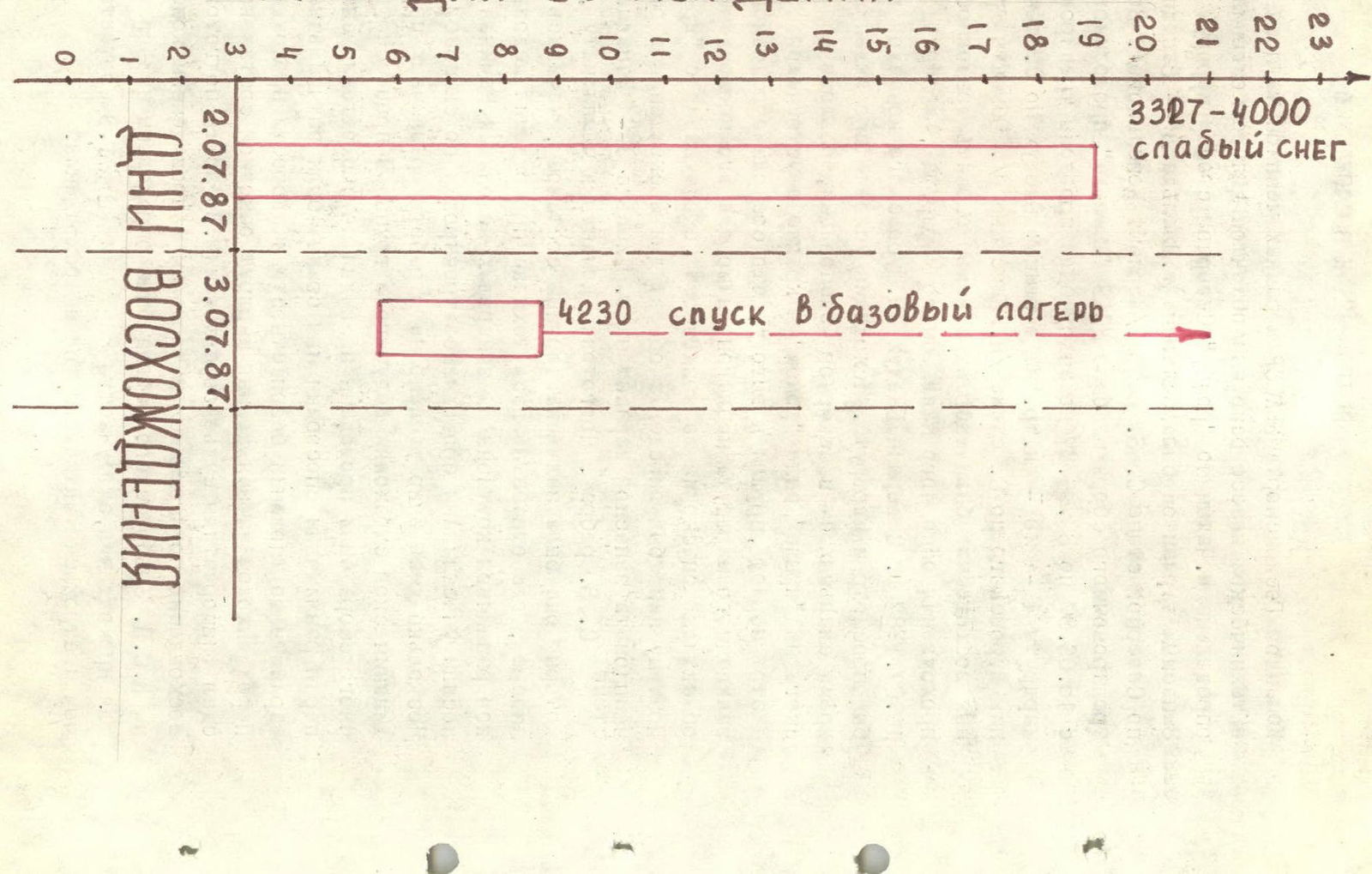
- Exit to the route: July 2, 1987.
- Summit – July 3, 1987, 8:30.
- Return – July 3, 1987, 20:30.
- State Committee for Sports of the Kabardino-Balkarian ASSR under the Council of Ministers of the Kabardino-Balkarian ASSR.
Distance: 10 TOVIER SbENIER 3.3utсота TOVIER 3300 m.
Profile of the wall from the right. July 2, 1987 11:00.
- Lens type: MIR-1
- Focal length: 37 mm
- Distance: 2 km
- Point number: № 5
- Height: 2900 m
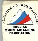
Distance to the object — 500 m. Shooting point number № 4. Height 4230 m.
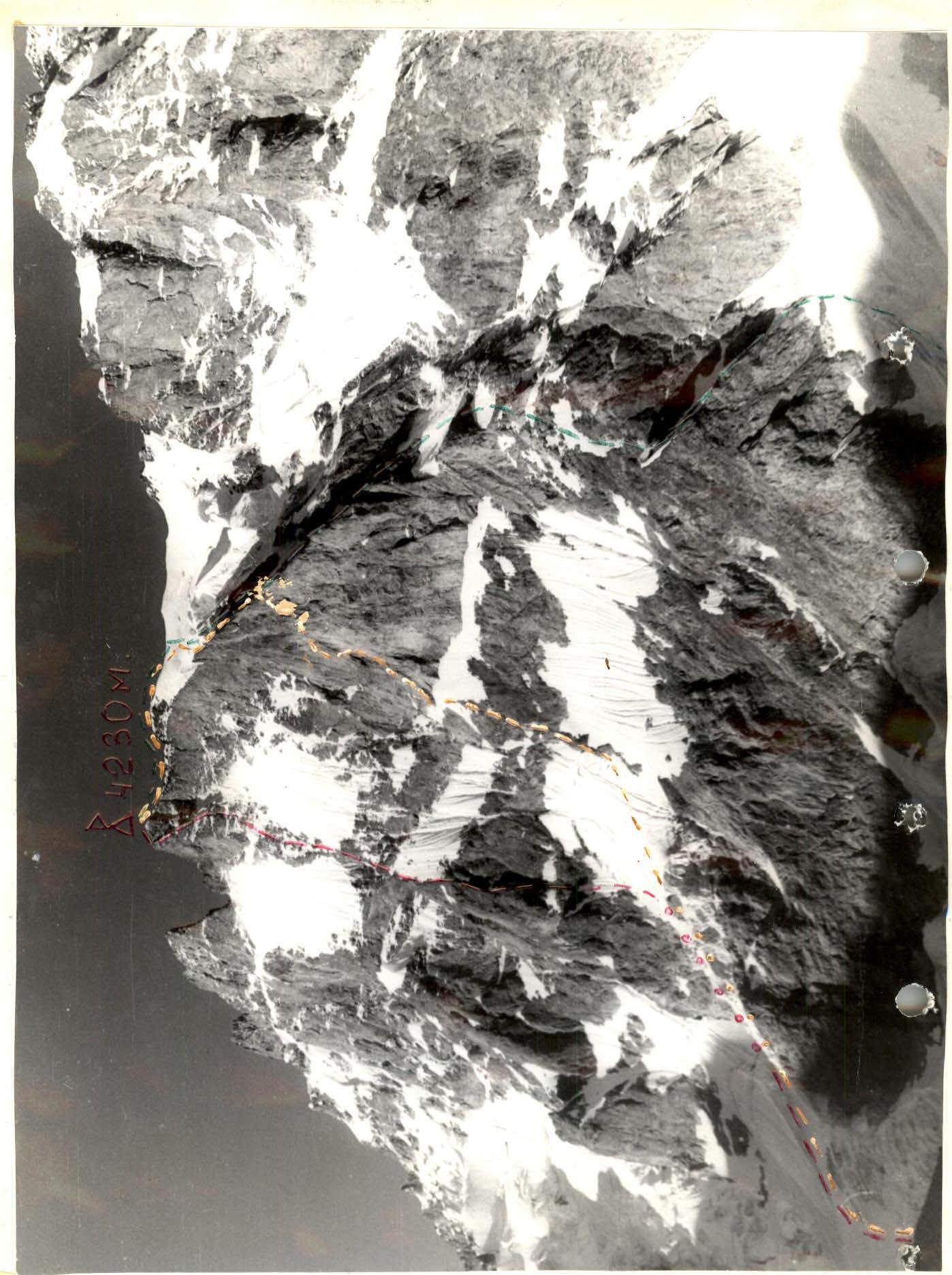
Profile of the wall from the left. July 3, 1987 8:30. Lens type 7-43. Focal length 40 mm. The team of the State Sports Committee of the Kabardino-Balkarian ASSR, as part of the championship in mountaineering in the technical class, had identified Mt. Chatyn via the "diamond" of the North wall, Myshlyaev's route, as the main object for the ascent. The backup option was Shkhelda 3-western via the North face of the NW ridge (Kensitskiy's variant).
During the training camp at the USAB "Shkhelda" base, held from June 15, 1987 to June 30, 1987, the team completed training routes of 4 and 2 categories of difficulty on the peaks:
- Bzhedukh via the North face,
- Shurovsky peak via the North face (Kensitskiy's route).
The objects of training ascents were chosen to assess the feasibility of completing the main declared route between July 1 and July 10, 1987. From the tops of Bzhedukh and Shurovsky, the team thoroughly examined the route. Based on the conditions of passage at that time for the northern exposure rock walls, the large amount of snow on the "roof" above the "diamond", and the extremely unstable weather during this period, they concluded that the state of the main declared route was unfavorable for passage and even objectively dangerous due to the possibility of avalanches from the "roof".
Therefore, we identified the object for the ascent as part of the championship – a backup option on Shkhelda 3-western via the North face of the NW ridge.
The team's preparation for the championship, for which they were registered with a double roster, began in January, where they practiced techniques for passing icy sections of varying steepness on frozen icefalls. Starting in March, the participants trained in rock climbing techniques. Several days were devoted to practicing various techniques of dynamic belaying of the lead climber in the group. During the training camp, they conducted trial runs for passing complex pitches using various methods and chose the optimal options in terms of safety and speed.
Before heading out on the declared route, the main team members passed physical fitness tests to the competition judge. During preparation for the ascent, based on available materials and consultations on the category of difficulty in the Elbrus region, the most dangerous sections for passage were identified: R0–R7 and R19–R20. The tactical plan for the ascent was built accordingly.
Hours of the Ascent Day
Team's Tactical Actions
There were practically no deviations from the tactical plan in terms of time on the route. The only deviation was that the summit, planned for 10:00 on July 3, was reached earlier, at 8:30 on July 3. Having planned the overnight stay at the vertex of the triangle, due to weather conditions (strong wind, light snow), it was decided to move it 2 ropes down, to the ridge of the triangle. On a large snow drift on the rocky ridge, a comfortable lying down overnight stay was organized.
The lead rope team worked with a single "Elita" ULA rope, 12 mm. The movement of the rest of the group was carried out, where required, with alternate belaying, along the ropes with top rope belaying. The type of rope used: VTsSPS 10 mm.
Movement along the route, in accordance with the tactical plan, was carried out as follows:
- Section R0–R1 — simultaneous movement.
- R1–R7 — rope team Rozin – Efremov.
- R7–R16 — rope team Sklyarov – Shcherbachev.
- R16–R19 — rope team Bezrodny – Pilizin.
- R19–R20 — simultaneous movement.
Descent was made via the ascent route.
Belay stations were organized on at least 2 blocked pitons with additional backup using chock stones. Belaying of the lead climber in the group was done through a braking device such as a "Figure Eight" and a Koshewnik's washer. The movement along the route was very intense and was subordinated exclusively to the safety of passing various sections of the route.
Duration:
- 1 day – 16 hours
- 2 day – 15.5 hours
Food on the route was individual: each team member had "pocket food" in the form of prunes, raisins, oatmeal cookies, and a flask with apple juice and water. On the bivouac, they prepared freeze-dried mashed potatoes with stew, soup from concentrates, and tea (see the nutrition table).
The bivouac arrangement met all safety requirements and conditions for normal rest for the entire team (see the equipment table).
The route did not present any particular difficulties for passage, so movement was carried out without unnecessary pauses. Equipment and food, as well as fuel, were taken at the rate of a day of bad weather, since even a small amount of snow on the rocks in the section R7–R31 would significantly complicate the passage of the route.
Anticipating such an option, during preparation for the championship, training was conducted on passing complex rocky sections in crampons. For the lead climber to pass complex steep and overhanging sections, instead of standard ladders, so-called "hook-legs" and ladders with metal rings were used.
While the team worked on the wall, 3 participants from the training camp, led by the team coach, were constantly present at the bivouac under the route, ready to provide necessary assistance at any moment. The bivouac was positioned so that the team was constantly in the field of view of the observers (see the observation log).
Communication with the rescue team was carried out using an R/ST "Lastochka" radio station. After our radio broke, voice communication was established with the observers. We were audible until we reached the summit — the triangle.
According to the tactical plan, we had 3 options for descending from the summit (see the tactical plan). But after losing radio contact, the descent route was determined unambiguously – via the ascent route, although technically this is the most difficult option, since the direction of descent is always diagonal. The section R12–R13 was descended by climbing down due to the impossibility of organizing a rappel.
The radio breakdown, as it turned out, was quite serious; under ascent conditions, it was technically impossible to resolve.
Table of food and fuel.
| № | Name of food and fuel | Weight, kg | Quantity, pcs. |
|---|---|---|---|
| 1. | Canned meat | 1.0 | 4 |
| 2. | Soup concentrate | 0.28 | 4 |
| 3. | Crackers | 0.7 | – |
| 4. | Sugar | 1.0 | 1 |
| 5. | Freeze-dried potatoes | 0.25 | 1 |
| 6. | Tea | 0.20 | 1 |
| 7. | Oatmeal cookies | 1.0 | – |
| 8. | Prunes | 0.6 | |
| 9. | Raisins | 0.6 | |
| 10. | Chocolate candies | 0.6 | |
| 11. | Apple juice | 2.0 | |
| 12. | Water | 2.0 | |
| 13. | Gasoline | 2.0 |
Total 12 kg 230 g. Food per person per day – 850 g.
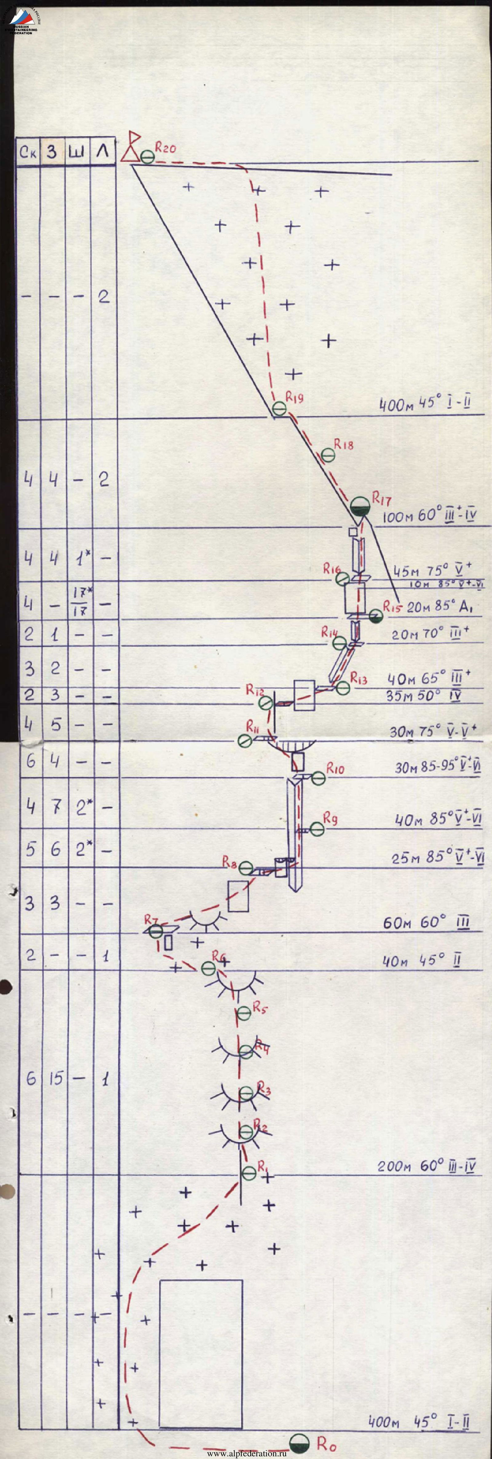
R0–R1 — from the initial bivouac along the lateral moraine of the Shkhelda glacier, move towards the large avalanche cone under the North wall of the Shkhelda massif. Up the cone, bypassing the rocky wall and icefalls on the left, exit to the snow-ice fields above them and move up to the right towards a gentle rocky ridge leading to the base of the triangle. The section is technically simple.
R1–R6 — reach the rocky ridge and move straight up along it towards the triangle. Rocks are like "ram's foreheads", strongly smoothed, but not steep, местами covered with ice. Movement with variable belaying.
R6–R7 — along a moderately steep snow-ice slope, exit to a wide, rubble-covered platform at the base of the triangle.
R7–R8 — from the ledge along moderately difficult rocks like "ram's foreheads" up to the right to a small ledge for two.
R8–R9 — from the ledge, traverse 10 m to the right, first along simple, then along difficult rocks under the overhang and further to the right onto steep, smoothed slabs on the right side of the large inner corner. Then straight up 20 m to a small ledge for one person. Rocks are steep, strongly smoothed slabs, few cracks for organizing belay points.
R9–R10 — further straight up along difficult rocks of the steep, smooth wall to a ledge for two under the rusty overhang. Climbing is very difficult, but there are many cracks for organizing reliable belay points.
R10–R11 — from the ledge straight up along the slab under the rusty overhang and through it, exit to a small inclined ledge above the overhang at the base of a not clearly defined steep outer corner.
R11–R12 — along difficult rocks on the left side of the outer corner, 20 m up to its slight flattening. Move to this place by traversing to the right and up to a small, not clearly defined ledge.
R12–R13 — from the ledge along moderately difficult, местами complex rocks, traverse to the right 30 m to a not wide, but convenient ledge.
400 m 45° 1–2
R13–R14 — from the ledge along moderately difficult rocks of the inclined inner corner, exit to the next fairly wide ledge under the steep, strongly destroyed inner corner.
R14–R15 — along moderately difficult, destroyed, steep rocks of the inner corner to a wide ledge under the steep, smooth wall. On the ledge, a platform for a tent.
R15–R16 — from the left part of the ledge straight up along the wall (on the wall, a bolted route), 20 m, then 10 m free climbing along difficult rocks of the wall to an inclined ledge at the base of the large inner corner.
R16–R17 — from the ledge straight up along difficult rocks on the right side of the inner corner under the rusty wall. Traverse this wall to the right and exit to the ridge of the "triangle". Here, on the flattening of the ridge and partially on a large snow drift, a bivouac.
R17–R19 — from the bivouac along moderately difficult and местами difficult, icy rocks of the ridge, exit to its summit. Rocks are snow-covered, and there is a lot of ice on them.
R19–R20 — from the summit of the triangle straight up along the steep snow-ice slope, exit to a simple rocky ridge and along it to the left to Shkhelda Western peak.
Descent was made via the ascent route.

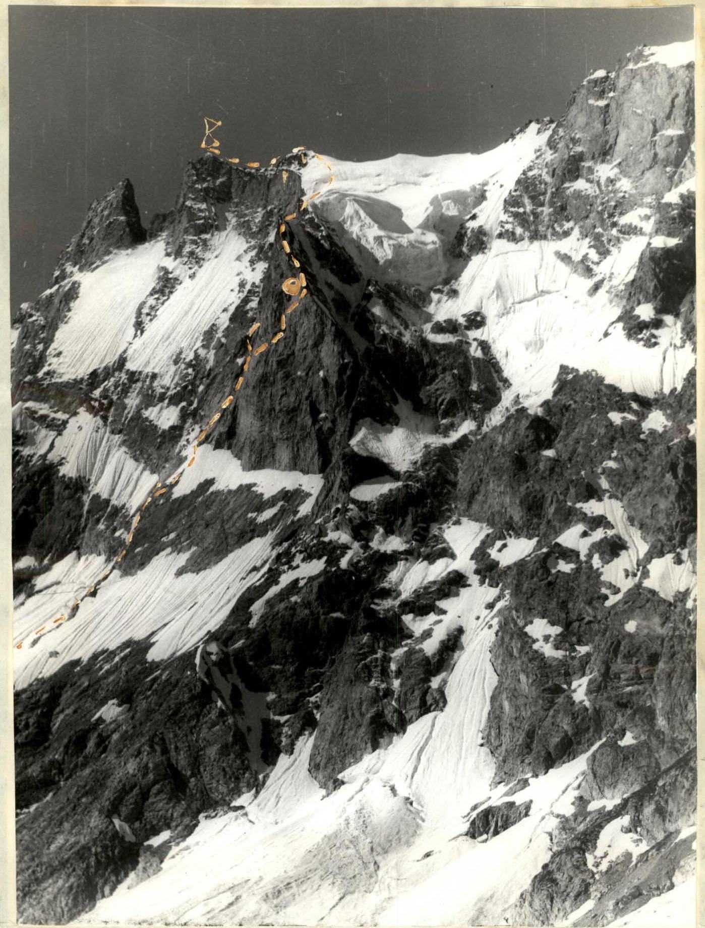
Technical photograph of the wall. July 1, 1987 9:00. Lens: Jupiter 9. Focal length: 8 mm. Point number: № 1. Distance: 2 km. Height: 3200 m.