Report
on the first ascent of the South Ushba (4710 m) west wall by the "Digoriya" alpine camp team
consisting of:
-
- Slesov I.V. — team captain, Master of Sports of the USSR
-
- Shevandrin N.I. — deputy captain, Candidate for Master of Sports
-
- Dzhioev G.L. — Master of Sports of the USSR
-
- Mikhalev V.E. — Candidate for Master of Sports
Rostov-on-Don 1977
Brief geographical description and sporting characteristics of the ascent object
The twin-peaked Ushba is the most popular and arguably the most inaccessible peak in the Caucasus, attracting the attention of mountaineers for over 100 years. Douglas Freshfield introduced it to mountaineering in 1868.
Twenty years later, in 1888, English mountaineer D. Cockin and Swiss guide U. Almer ascended from the Gul glacier to the saddle and from there to the North peak (4695 m). During an attempt to ascend to the South peak, Cockin fell. Losing a boot forced the brave duo to descend.
Over the next 15 years, 22 expeditions from England, Germany, France, Austria, Switzerland, and the USA attempted to conquer it. In 1903, members of the Swiss-German expedition led by A. Shults climbed the southeast wall, crossed the "tie" at its upper part, and ascended to South Ushba (4710 m) via the "red corner". The first traverse of Ushba (from north to грунziologist V. L. Semonovsky, the first Soviet climber.
In the following years, over 900 Soviet and around 100 foreign climbers conquered Ushba. The Ushba routes were featured over 30 times in the USSR championships.
By 1977, 31 routes had been laid on Ushba, with 22 of them established during the country's championship years. Climbers received:
- 50 gold medals,
- 30 silver medals,
- 25 bronze medals.
The "Conquered Peaks" collection and periodicals have thoroughly documented the epic struggle for Ushba. Here, we will briefly highlight the most interesting ascents.
1954 — a group led by V. Staritsky ascended the southeast wall. 1955 — climbers from the Georgian Alpine Club, led by Marr, ascended the northwest wall.
1958 — L. Myshlyaev and V. Nikolaenko ascended the West wall ("Gold medals").
1959 — army athletes led by V. Nekrasov stormed the Northeast wall ("Silver medals").
1960 — three teams attempted to storm the bastion at the junction of the west and southwest walls:
- Muscovites led by L. Myshlyaev,
- army athletes under V. Nekrasov's leadership,
- Ukrainians led by V. Monogarov.
However, this bastion remained unconquered. L. Myshlyaev and O. Kosmachev bypassed the bastion to the left via the west wall, while the Monogarov team chose a path to the right via the southwest wall.
1961 — army athletes led by V. Nekrasov traversed the east wall.
1962 — a team of army climbers, led by G. Zhivlyuk, laid a path along the northwest ridge of the South peak and became champions of the country.
1963 — Ukrainian climbers under A. Kustovsky's leadership attempted to ascend the southwest wall.
1965 — Ukrainian climbers led by V. Monogarov conquered the bastion at the junction of the west and southwest walls ("Gold medals").
1966 — army athletes under A. Tkachenko's leadership overcame the east wall ("Bronze medals").
1971 — a group of instructors from Adyl-Su, led by Yu. Artsingevsky, ascended the center of the northwest wall ("Silver medals").
A group of Rostov climbers, led by Nepomnyashchy, ascended the southwest wall of South Ushba ("Bronze medals").
1972 — a group of instructors from Alibek, led by Yu. Grigorenko and Prigoda, ascended the southwest wall ("Gold medals").
Thus, over 18 years, 14 new wall routes were established on South Ushba alone. Including routes on the North peak's northeast wall by M. Khergiani's group in 1964 and V. Monogarov's group in 1967, it became clear that finding an interesting path on Ushba was a complex task in itself.
There are no easy paths to the summit on either peak of Ushba. They are located in one of the spurs of the Main Caucasus Range, with the North peak connected to it via the north ridge — the most accessible path to Ushba.
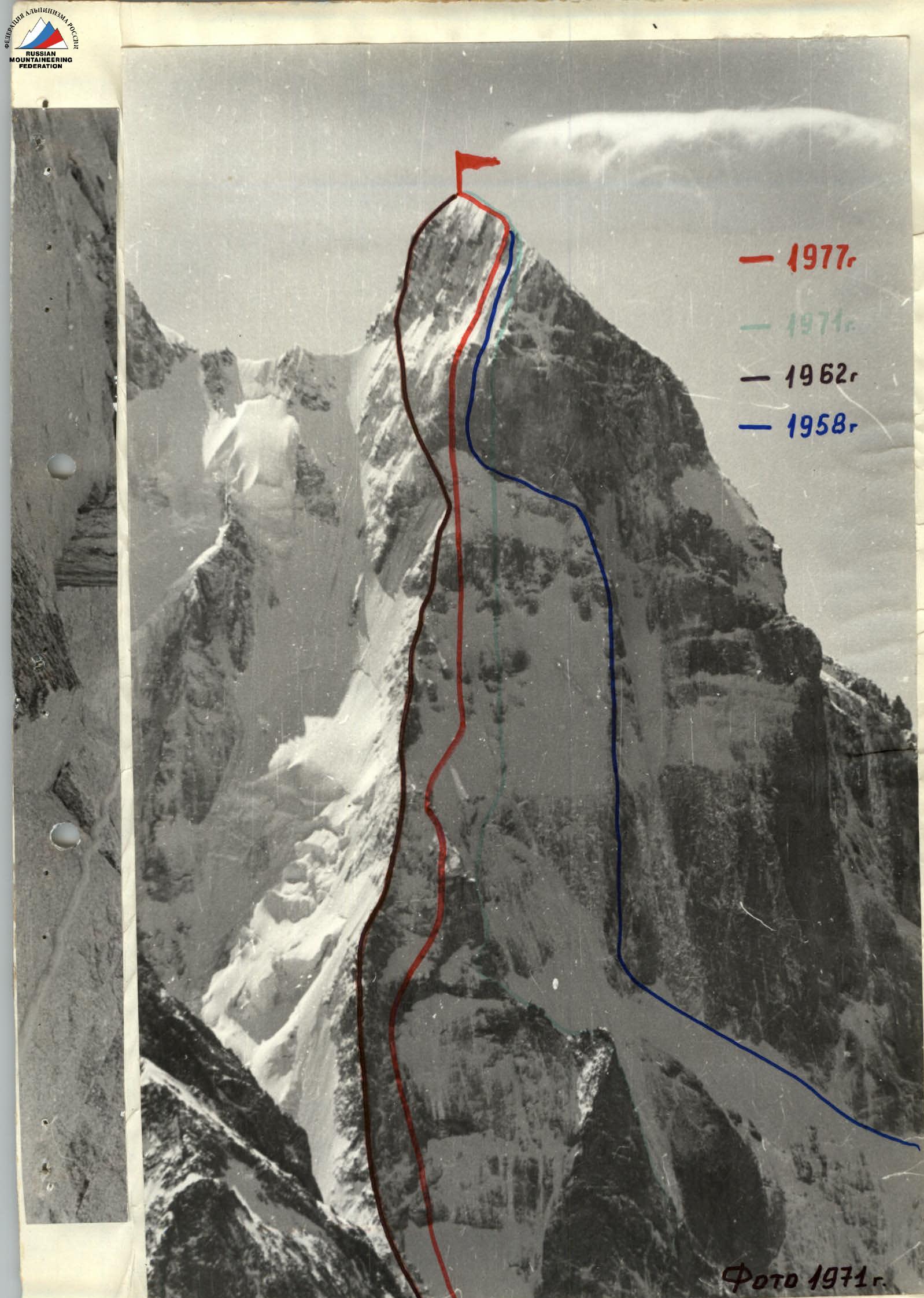
The west wall is a different story. This wall is perhaps the most grandiose wall in the Caucasus, dropping steeply to the Ushba glacier by 2000–2200 meters.
At an altitude of 4500–4550 meters:
- The "roof of South Ushba" ends in a 300-meter basalt bastion, with its upper half overhanging;
- the bastion is shaped like a spade blade pointing upwards.
Below the bastion are steep snow-ice fields (depending on the season), interrupted in the middle by a vertical rock belt, followed by steep rock walls (800–900 meters) between the northwest ridge of South Ushba and the southwest counterfort.
The history of this wall's conquest is as follows: in 1954, the "Spartak" team led by Honored Master of Sports of the USSR V.M. Abalakov and the Georgian Alpine Club team eyed this wall.
The planned routes practically coincided: counterfort, via "islands" through the rock field under the bastion, then left to bypass the bastion onto the saddle between North and South Ushba. The Georgian climbers were the first to start.
For unknown reasons, the Spartak team changed their plans, went to Bezengi, and ascended the North wall of Dykh-Tau. The Georgian climbers attempted to traverse the counterfort but were unsuccessful.
The following year, the Georgian Alpine Club team, led by Marr, overcame the west wall via the simplest path, crossing it from right to left along the least steep sections, exiting onto the saddle and then to South Ushba.
In 1957, a group of climbers led by A. Ovchinnikov ascended to the bastion via the route known in climbing circles as L. Myshlyaev and V. Nikolaev's path. Continuing straight up, the group managed to overcome only half of the bastion. A lack of pitons forced them to descend.
In 1958, L. Myshlyaev and V. Nikolaenko approached the bastion via A. Ovchinnikov's path but also failed to ascend it directly. Traversing left, they exited onto the "roof" via the left part and then to the summit.
In 1960, L. Myshlyaev and O. Kosmachev ascended the west wall to the right of the 1958 route. Again, unable to overcome the bastion, they turned right onto the southwest ridge of South Ushba.
In 1962, army athletes overcame the steep northwest ridge and, leaving the bastion to the right, traversed left and upwards across the northwest pre-summit slope, exiting onto the usual path leading to the summit. As evident, the history of South Ushba's conquest is rich, and given the particular popularity of routes on the west wall, the difficulty that arises before each group attempting to lay a new path on the wall is understandable.
Careful study of photographs and direct observation of the wall in previous years allowed our team to plan a route not inferior in complexity to neighboring routes on the west wall and, in its lower part, more complex and unique. In our view, the route is logical and practically safe.
Organization and tactical plan of the ascent
Preparing for the country's championship in the 1977 season, our team developed a detailed tactical plan for the future ascent. In the winter, we focused on 20–25 km runs in any weather, betting on:
- endurance;
- ability to withstand low temperatures.
To test the group's performance on the route in low temperatures, a winter ascent of 5B category difficulty was planned. In early January, such an ascent was made on Malaya Nakhshbit. Preliminary training included a 3A category difficulty route. Spring months were also filled with intense training. The team planned to ascend Dalar (5B–6B category difficulty) in early May.
Between May 1st and 7th, the northeast ridge of Dalar was traversed (5B category difficulty). Prior to that, a 4A category difficulty ascent was made for team cohesion. The team participated in a Pamir expedition, where they completed high-altitude ascents on Peak Korzhenevskaya and Peak Kommunizma. Only after the expedition did the team travel to the Caucasus, to the Ushba area.
Due to the nature of the terrain, the route on the West wall of South Ushba is combined, featuring steep snow-ice slopes, rock walls, ledges, ice shelves, and "knives." The most technically challenging sections of the route — the counterfort wall and the bastion — determined the number of necessary ropes (2 × 80 m and 1 × 40 m) and pitons:
- rock pitons — 55;
- shovel pitons — 40.
Experience from our previous wall ascents (north walls of Chatyn, Dzhigit, southwest wall of South Ushba, south wall of Kirpich, etc.), as well as preliminary familiarity with the route's character, allowed us to outline a tactical plan for the ascent, which was largely adhered to despite harsh climatic conditions (a 4-day snowfall during the initial days of the ascent).
The plan was to ascend the route directly, without prolonged preliminary processing of wall sections. The food ration and product selection were based on this. The only deviation from this plan was at the beginning of the route (second day — due to heavy snowfall). One day was spent on preliminary processing of the lower part of the bastion, as anticipated.
In our opinion, the set of equipment is optimal for the given route. The food ration, primarily consisting of sublimated products (cottage cheese, potatoes, meat, lemons), allowed for high-calorie nutrition while significantly reducing backpack weight, enabling infrequent rucksack transfers. This increased the pace of movement, which matched the planned pace (except for the lower part due to bad weather). In the second half of the ascent, the group had 3 backpacks for 4 participants.
Four control cairns were established on the route:
- I cairn — in the lower part of the wall on a shelf;
- II cairn — upon exiting onto the top of the southwest counterfort;
- III cairn — on the second rock "island";
- IV cairn — in the lower part of the counterfort leading to the summit ridge.
If not for the terrible weather at the beginning of the route, the number of walking hours could have been reduced.
Movement on the route by days
August 13, 1977 — departure from the "Baksan" alpine camp; transition through the Becho pass to the meadow.
August 14, 1977 — transition from the meadow to the "hunting camps".
August 15, 1977 — approach to the route, inspection of the route.
August 16, 1977 — at 6:00 AM, departure from the storm camp to the shoulder of the southwest counterfort, crossing the partially destroyed icefall, and approaching the base of the wall. At 10:00 AM, work on the wall began. Visibility 30–40 meters, fog, wind. Snow in the second half of the day. The entire day, the Shevandrin-Mikhalev team worked ahead with alternating lead. 200 meters of the wall were traversed during the day. Rucksacks were pulled up in the upper half of the section. Overnight stay on a shelf in a suspended tent. I control cairn.
August 17, 1977 — heavy snowfall throughout the night. Met conditions persisted in the morning, with strong wind. Nevertheless, the Slesov-Dzhioev duo began processing at 9:00 AM. The bivouac was not dismantled. Besides snowfall, wind-blown snow from the rocks made it difficult to lift one's head. Ice axe and hammer were used to clear ledges, holds, and cracks for pitons. Progress was steady, with good sections of 30 and 10 meters traversed. Snowfall continued until 17:00, but they had worked about 200 meters of the wall. Descent to the tent. Snow continued. The team was covered in snow. Rest.
August 18, 1977 — 9:00 AM. Wind and snow persisted. Dismantled the bivouac and ascended via fixed ropes. Ropes were icy. 200 meters were traversed in 4 hours. A small chimney was passed, followed by a shelf, an inner corner, and a wide snow-ice shelf. The Shevandrin-Mikhalev duo continued working on the route, heading towards the "red" 80-meter wall. Slesov-Dzhioev prepared a platform for the tent. First decent overnight stay. Shevandrin-Mikhalev worked until 19:00, processing 100 meters of an oblique snow-ice shelf and 40 meters of the "red" wall. Continuous snowfall and strong wind persisted throughout the day. Visibility 15–20 meters, occasionally up to 30 meters.
August 19, 1977 — 9:00 AM. Bivouac dismantled, ready to depart. Extremely cold. Strong wind blowing snow off the walls. Relief came from glimpses of sun. Weather changed throughout the day, with wind dying down by evening and visibility improving. Still very cold. Photographed the slopes, white as snow. Traversed fixed ropes, passed the upper part of the "red" wall, and exited onto a broad ridge (slabs, massive blocks) onto the counterfort's summit. Overnight stay. II control cairn. The platform was again suitable for a normal overnight stay. The Slesov-Dzhioev duo worked ahead throughout the day.
August 20, 1977 — first night without snowfall. Clear, but still cold. Departed at 9:00 AM, traversing an ice slope towards the middle "island" series (four islands). Shevandrin-Mikhalev led. Ice technique was employed:
- 12-tooth crampons (Austrian type);
- titanium ice pitons;
- ice axe.
Ice was nearly bare, with snow not adhering to it. Weather finally stabilized. The lead climber proceeded without a rucksack, carrying only foam and a down jacket. Reached the second island via ice. Left the III control cairn. Bypassed the islands to the left. Insurance via rock and ice pitons. Exited onto a snow-ice "knife" leading to uncomplicated rocks. On the rocks, Mikhalev reached a snow-ice shelf and an inner sheer corner by 19:00. Set up a tent on a tiny ledge. Semi-reclined overnight stay. Good weather was reassuring. 485 meters of the route were traversed in 10 hours (360 meters of ice and 125 meters of rocks).
August 21, 1977 — morning was beautiful, calm, and sunny. Departed at 9:00 AM. 40 meters of wall and over 200 meters of ice with rock outcrops. Slesov-Dzhioev duo worked ahead. Reached 240 meters by 15:00. The lead climber worked without a rucksack. Approached the base of the bastion. Carved a 2.5-meter "pocket" in a 60° ice slope at the base of the rocks. Suspended the tent on shovel pitons. A good sitting bivouac in the tent.
August 22, 1977 — at 9:00 AM, the Slesov-Dzhioev duo began processing the sheer bastion. Very difficult climbing with artificial points of support. Used ladders, platforms, and occasionally shovel pitons. Weather was again pleasant. Good visibility, no precipitation. Only strong wind and cold. Processed 80 meters by 19:00 and descended to the bivouac.
August 23, 1977 — and again departed at 9:00 AM. Packed 3 rucksacks. Slesov-Dzhioev led again. Shevandrin-Mikhalev followed upon signal. After traversing 80 meters on fixed ropes, the lower duo evacuated, and we continued ascending. Processed another 70 meters of wall. On a small shelf, three gathered. Traversed another 20 meters of slabs and 45 meters of snow-ice slope. All four gathered here. Set up bivouac at 19:00. On a rock ledge, suspended a hammock for two, and the other two carved niches in the ice slope on either side. Night was restless due to strong wind. Wall was nearly behind.
Remaining was the counterfort leading to the ridge about 100 meters right of the summit. IV control cairn in the lower part of the counterfort.
August 24, 1977 — dismantled bivouac at 8:00 AM. Mikhalev-Shevandrin duo led. Ascended the counterfort (snow, ice, rocks) and reached the ridge leading to the summit by 13:00. Reached the summit at 13:30. Traversed 160 meters of counterfort and 110 meters on the ridge. Retrieved a note from the instructors' school dated August 16, 1976. A whole year had passed since anyone had been on the summit of South Ushba. Began descent at 15:00. Set up overnight stay on a shelf between the 1st and 2nd rappels.
August 25, 1977 — descended to the "Red Corner", approached the "Mather's tooth", bypassed it via a shelf to the right, and descended below the saddle, setting up one 40-meter and two 60-meter rappels. Reached the "hunting camps" by 19:30, meeting the observation group.
Ascent completed.
Table of main characteristics of the ascent route
Ascent route: South Ushba via the west wall. Route length: 1931 meters (excluding the icefall) Sections with an angle of 80–90°: 300 meters Average steepness: 67°
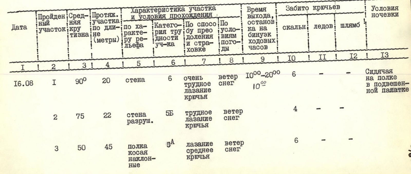
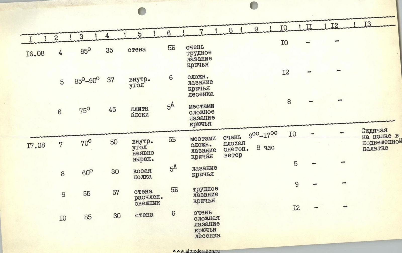
| Date | Section # | Average steepness | Length (meters) | Terrain characteristics | Category difficulty | Means of overcoming and belay | Weather conditions | Departure time, overnight stay, walking hours | Pitons driven (rock) | Pitons driven (ice) | Pitons driven (shovel) | Overnight stay conditions |
|---|---|---|---|---|---|---|---|---|---|---|---|---|
| August 16 | R1 | 90° | 20 m | wall | 6 | very difficult climbing, pitons | wind, snow | 10:00–20:00 (10 hours) | 6 | sitting on a shelf in a suspended tent | ||
| R2 | 75° | 22 m | destroyed wall | 5B | difficult climbing, pitons | wind, snow | — | 4 | — | |||
| R3 | 50° | 45 m | oblique sloping shelf | 5A | medium climbing, pitons | wind, snow | — | 6 | — | |||
| R4 | 85° | 35 m | wall | 5B | very difficult climbing, pitons | — | — | 10 | — | |||
| R5 | 85°–90° | 37 m | inner corner | 6 | complex climbing, pitons, ladder | — | — | 12 | — | |||
| R6 | 75° | 45 m | slabs, blocks | 5A | partly complex climbing, pitons | — | — | 8 | — | |||
| August 17 | R7 | 70° | 50 m | inner corner, vaguely expressed | 5B | partly complex climbing, pitons | very poor, snowfall, wind | 9:00–17:00 (8 hours) | 10 | sitting on a shelf in a suspended tent | ||
| R8 | 60° | 30 m | oblique shelf | 5A | climbing, pitons | — | — | 5 | — | |||
| R9 | 55° | 57 m | dissected wall, snowfield | 5B | difficult climbing, pitons | — | — | 9 | — | |||
| R10 | 85° | 30 m | wall | 6 | very complex climbing, pitons, ladder | — | — | 12 | 1 | — | ||
| R11 | 90° | 10 m | wall | 6 | very complex climbing, pitons, ladders | — | — | 4 | — | |||
| R12 | 75° | 20 m | inner corner | 5B | climbing, pitons | — | — | 5 | — | |||
| August 18 | R13 | 90° | 5 m | chimney | 5B | difficult climbing, pitons | snowfall, wind, poor visibility | 9:00–19:00 (10 hours) | 2 | normal in a tent | ||
| R14 | 70° | 20 m | shelf, inner corner | 5B | difficult climbing, pitons | — | — | 5 | — | |||
| R15 | 55° | 100 m | snow-ice shelf | 5A | on crampons, belay via pitons | — | — | 9 | 2 | — | ||
| R16 | 70° | 40 m | wall covered in snow | 6 | very difficult climbing, ladder, pitons | — | — | 12 | 1 | — | ||
| August 19 | R17 | 90° | 40 m | wall with vertical cleft | 6 | very difficult climbing, ladders, pitons | — | 9:00–17:00 (8 hours) | 11 | 2 | 1 | normal in a tent |
| R18 | 60° | 120 m | eroded ridge, slabs, massive blocks | 5B | difficult climbing, pitons | — | — | 15 | — | |||
| August 20 | R19 | 60° | 40 m | ice slope | 5A | on crampons, ice pitons | good, clear, sunny, very cold | 9:00–19:00 (10 hours) | — | 5 | — | |
| R20 | 55° | 200 m | ice slope | 5A | on crampons, ice pitons | — | — | — | 15 | — | ||
| R21 | 65° | 80 m | rocks, ice | 5B | on hooks, belay, ice and rock pitons | — | — | 4 | 4 | — | ||
| R22 | 45° | 40 m | snow-ice "knife" | 5A | on crampons, belay via pitons | — | — | 3 | — | |||
| August 21 | R23 | 55° | 40 m | rocks of medium difficulty | 5A | climbing, pitons | — | — | 6 | — | ||
| R24 | 55° | 45 m | snow-ice shelf | 5B | on crampons, ice and rock pitons | — | — | 5 | 1 | — | ||
| R25 | 90° | 40 m | inner corner | 6 | very difficult climbing, pitons | — | — | 15 | — | |||
| R26 | 85° | 35 m | wall | 6 | difficult climbing with ladders, pitons | good, clear, wind | 9:00–15:00 (6 hours) | 10 | 1 | sitting in a suspended tent in an ice "pocket" | ||
| R27 | 60° | 200 m | ice slope with rock outcrops | 5B | on crampons, ice and rock pitons | — | — | 5 | 10 | — | ||
| August 22 | R28 | 90° | 80 m | wall with a break | 6 | very difficult climbing with platforms, pitons | good, clear, wind, cold | 9:00–19:00 (10 hours) | 35 | 1 | 12 | sitting in a suspended tent in an ice "pocket" |
| August 23 | R29 | 80° | 70 m | wall, slabs | 6 | very difficult climbing with ladders | good, clear, wind, cold | 9:00–19:00 (10 hours) | 26 | 6 | sitting in a hammock in an ice niche | |
| R30 | 75° | 20 m | slabs | 6 | very complex climbing with ladders | — | — | 11 | 12 | — | ||
| R31 | 60° | 45 m | ice slope | 6 | on crampons, belay via pitons | — | — | 1 | 5 | — | ||
| August 24 | R32 | 60° | 160 m | snow-rock-ice ridge | 5B | on crampons, climbing, ice and rock pitons | — | 8:00–13:30 (5 hours 30 minutes) | 14 | 2 | — | |
| R33 | 35° | 110 m | southwest ridge | 3B | simple climbing via ledges | — | — | — | — | |||
| Total: | 1931 m | 77 hours 30 minutes | 277 | 51 | 24 |