Ascent Passport
I. Winter ascent category 2. Central Caucasus 3. North Ushba, via the Northwest wall 4. Route 6A category of difficulty (route 181) 5. Elevation gain 1600 m, length — 2300 m
Length of sections with 5th category of difficulty — 1320 m. Average steepness of main sections — 58° (3800–4650), route: 49°
- Pitons hammered:
rock — 26, chocks — 6, ice screws — 85
- Team's travel time: 23 hours and days — 3
- Overnights: 1st platform carved on a snow-ice slope, 2nd and 3rd carved platforms on a snow-ice ridge, 4th — snow cave on descent.
- Team leader — Babanov Valery Pavlovich — Candidate Master of Sports
Team members: Zdanovich Igor Arnoldovich — Candidate Master of Sports, Altyshev Oleg Dzhafarovich — Candidate Master of Sports, Shagaev Pavel Leonidovich — Candidate Master of Sports. 10. Team coach: Kudashkin Yuri Valentinovich — Master of Sports of the USSR. 11. Approach to the route: 14.02.1991 Summit: 16.02.1991 Return: 19.02.1991 12. Organization — Omsk Regional Sports Committee
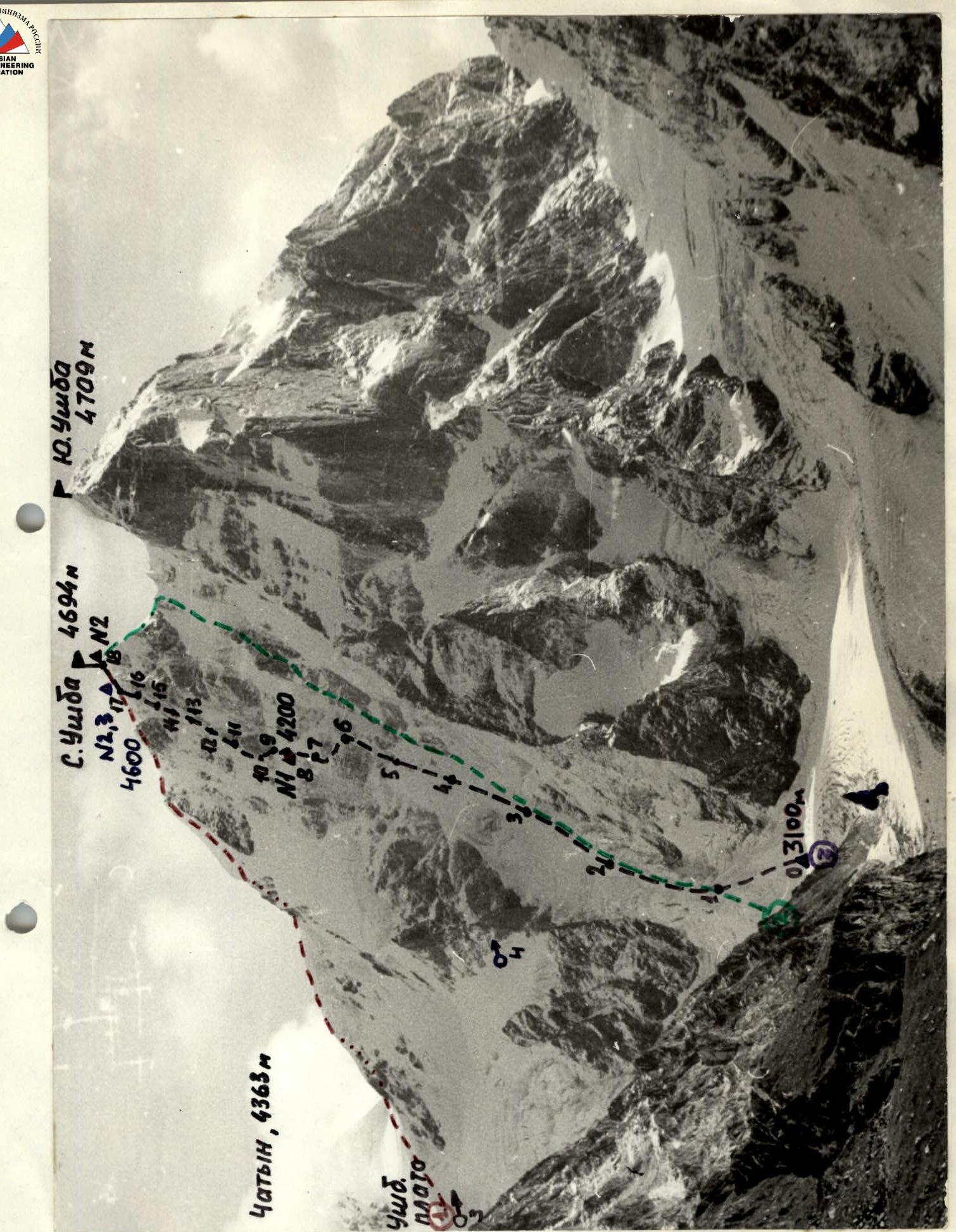
General photo of the summit. Taken from the South Irkeldinsky glacier. 1980. Summer. Lens "Industar – 61" F = 50 mm. Distance to the wall 4.5 km. H = 3300 m. Shooting point No. 1.
The following routes have been made:
- Route 1335, 4A category of difficulty.
- Route of the Omsk city team.
- Route 1958, 5A category of difficulty.
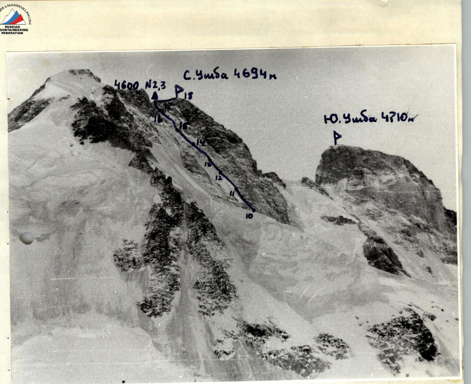
Profile of the wall on the left. February 13, 1991, 13:00. Lens "Industar – 22" F = 50 mm. Distance to the wall 1.5 km. Shooting point No. 3, H = 3900 m. When drawing up the tactical plan, the short winter day and the possibility of movement in bad weather were taken into account. The passage of the route was planned with two overnight stays on the ascent and one on the descent. In case of unfavorable weather, a doubling of the time schedule and the possibility of descending on the ascent route in case of bad weather were foreseen.
On February 12, 1991, the team left the Elbrus UMC at 6:00 am. They reached the Ushba plateau and spent the night. On February 13, by lunchtime, the team of 4 people approached the route. The remaining daylight was used to visually inspect the route.
The team started the route according to the tactical plan on February 14 at 4:00 am in the following rope teams: Babanov—Altyshev, Zdanovich—Shagaev. As planned, they approached the bergschrund (section R3–R4) under the first rock belt around 8:00. On this section, they moved quickly, with the leading rope team being Zdanovich—Shagaev. The first day was worked by this rope team. On section R4–R7, they moved on the front teeth of their crampons. The lead climber uses an ice axe and ice screws to traverse steep, extended ice sections. On sections with smooth rock slabs, rock pitons are used for protection. On ice, ice screws are used. The ice is hard and shatters in lenses. The first on section R5–R7 is Shagaev. The rope teams constantly interact. They move along fixed ropes using jumar.
At 16:00, they began preparing a site for an overnight stay with ice axes and a shovel on the upper part of the snow-ice ridge between the I and II rock belts.
On February 15, at 8:00, they continued their movement. The weather deteriorated sharply: visibility up to 50 m, strong wind with snow. The first rope team, Babanov—Altyshev, worked the entire day. Throughout the day, the ice was hard. In the upper part, there were heavily destroyed, ice-covered, and snow-covered rock sections. Movement was alternating. The rope teams interacted. Protection was mainly through ice screws.
At 18:00, three rope lengths from the summit, they reached the North ridge. Here, on the ridge, they carved out an overnight stay site for a tent.
February 16. The whole day was marked by strong wind with snow. Frost. Visibility was practically zero. After morning communication at 8:20, they moved along the North ridge to the summit. At 9:30, they ascended to the summit of North Ushba. The North ridge was heavily iced. Movement was alternating in rope teams on the front teeth of their crampons. Protection was through ice screws. Descent to the previous overnight stay site on the ridge.
February 17. No visibility. Frost. Strong wind with snow.
Due to the significantly deteriorated weather and almost zero visibility, a decision was made to:
- Start descending along the ascent route to the Ushba plateau.
- Descent was done using a rappel with the removal of ice screws, starting at 9:00.
- Overnight stay was organized at 16:00 with zero visibility on a snow cushion on the Northwest wall.
February 18. After radio communication at 10:50, they began their descent in conditions of zero visibility, with strong wind and snow. By 18:00, the team descended to the observers' tent located on the Ushba plateau.
Throughout the entire route, starting from section R4, the lead climber moved on a double rope, one of which was marked JAA. The second rope was used to secure the belay. Backpacks were carried on their backs:
- The lead climber on the route worked with a light backpack.
- On difficult sections — without a backpack.
During the ascent, there were no falls.
Hot meals were provided in the morning and evening. Throughout the day, all team members received high-calorie snacks.
Overnight stays were lying and semi-reclining on platforms carved in the ice, one — in a snow cave. Throughout the ascent and descent, stable radio communication was maintained with observers. A rescue team was constantly stationed under the route and in the Elbrus base camp.
Route diagram in symbols
M I: 4000
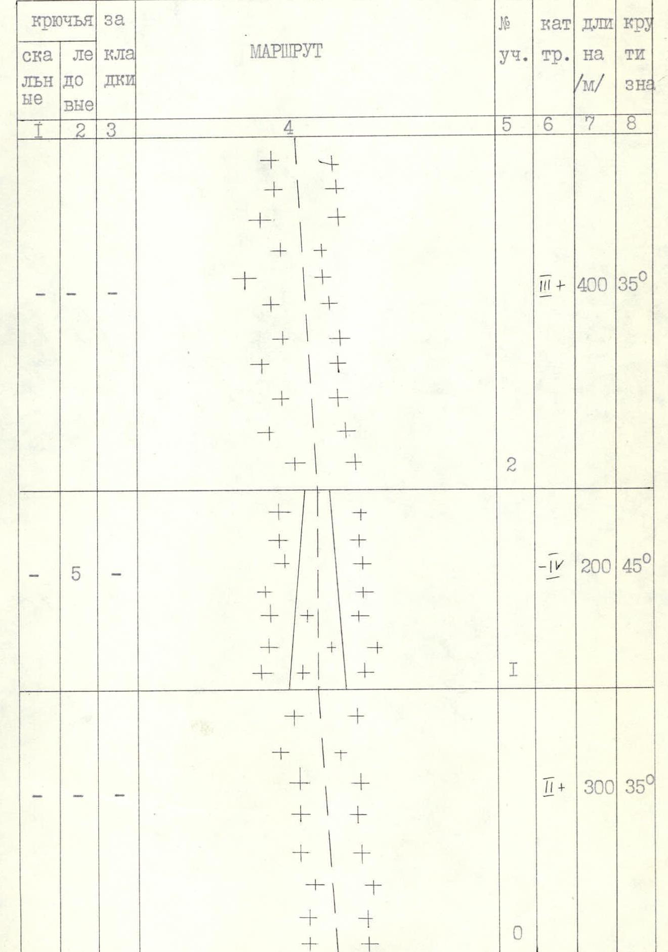
| Rock | Ice | Chocks | Route | Section No. | Cat. | Length /m/ | Steepness /°/ |
|---|---|---|---|---|---|---|---|
| 2 | 2 | 2 | 9 | V+ | 40 | 70 | |
| 1 | 2 | - | 8 | V- | 60 | 45 | |
| 3 | 6 | 1 |  3 закладок 3 закладок | 7 | V- | 140 | 45 |
| 4 | 6 | - | 6 | V+ | 120 | 60 | |
| 4 | 6 | - | 5 | V+ | 160 | 70 | |
| 6 | 8 | 2 | 4 | V- | 250 | 50 | |
| - | 4 | - | 3 | III+ | 200 | 40 |
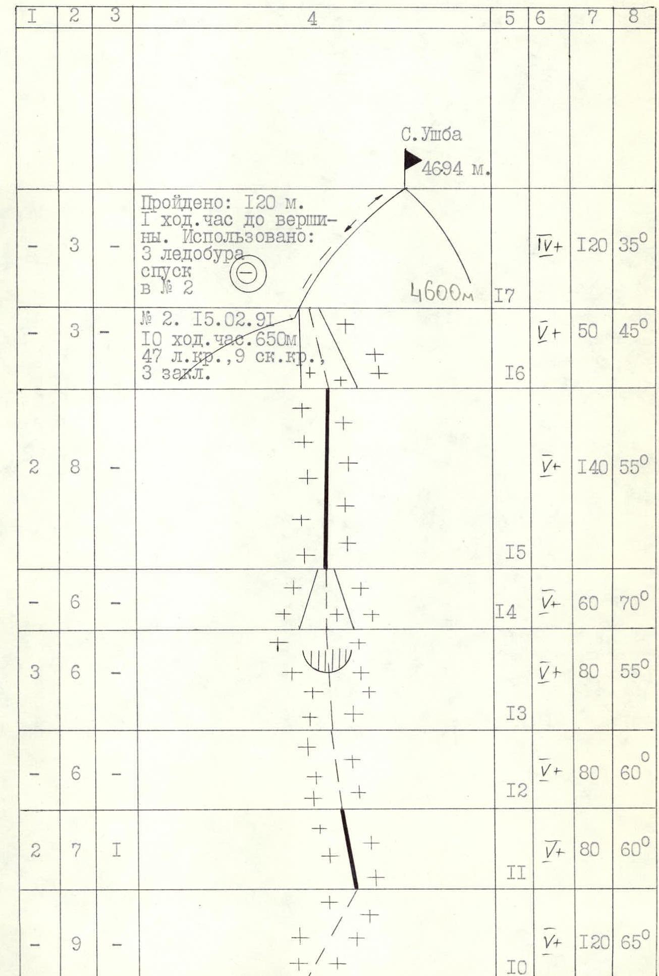
DAY I 14.02.1991 Section R0–R1. Simultaneous movement along a gentle glacier with closed crevasses in the direction of a gully in the middle part of the glacier. Rope team composition: Babanov—Altyshev, Zdanovich—Shagaev.
Section R1–R2. Steep ice-snow gully with open and closed crevasses. Alternating protection, piton, and also through ice axes.
Section R2–R3. Movement in the direction to the right of the hanging glacier above a small rock island and to the left of the large hanging glacier to the left of the "Cross" buttress.
Section R3–R4. Traverse of the hanging glacier to the right along a steep ice wall, then along an ice-snow slope in the direction to the left of rock islands under the 1st rock belt. The first rope team to work is Zdanovich—Shagaev. Protection through ice screws. Overcoming the bergschrund (photo 1, 2, 3).
Section R4–R5. Steep ice slope. Length about 250 m.
- In some places, the ice is covered with loose snow from 5 to 15 cm.
- Smooth rock slabs are covered with a layer of snow.
Protection through ice screws and rock pitons. The lead climber (Zdanovich) uses an ice axe for passage. The second rope team uses a fixed rope, moving with the help of a jumar and an ice axe (photo 4).
Section R5–R6. Further to the right and upwards along a steep (about 70°) ice-snow ledge to the right of smooth slabs of the 1st rock belt. The section is about 4 rope lengths.
Section R6–R7. Movement to the left and upwards under the "Trapeze" along snow-covered smooth slabs, then straight up along a steep smooth ice inner corner and an ice-snow slope. Exit above the "Trapeze" onto a vaguely expressed ridge. Photo 5
Section R7–R8. Steep snow-ice, vaguely expressed ridge leading in the direction of the left part of the II rock belt. The first to work is Shagaev. At 16:00, they all gather together on a snow ridge under a rock island two rope lengths from the II rock belt. They decide to stay here for the night. The weather is deteriorating, it is snowing. Photo 6. DAY II 15.02.1991
Section R8–R9. Weather is bad from the morning, snowing, strong wind. At 8:00, the first rope team Babanov—Altyshev begins movement along a steep complex ridge in the direction of two large smooth vertical spalled slabs.
Section R9–R10. From the slabs to the left and upwards along an ice gully between rock islands. Protection through chocks, rock, and ice screws. From here and further to the exit onto the North ridge, the rope teams interact.
Section R10–R11. Movement along a steep ice slope (ice is hard, shatters in lenses). There are snow-covered rock islands (photo).
Section R11–R12. Steep ice ridge with rock outcrops. The first uses ice screws and rock pitons for protection.
Section R12–R13. Movement along an ice slope to the left of a sharp ice-snow ridge under a rock wall.
Section R13–R14. Very steep, sharp ice-snow ridge about two rope lengths long, leading to the base of a rock tower.
Section R14–R15. Visibility is almost zero. Snowing. The route goes to the left of the rock tower along a steep ice gully. There are sections with rocks frozen in the ice. Protection through ice screws. In the upper part of the gully — exit to the left and upwards onto a sharp snow-ice ridge.
Section R15–R16. Upwards along the ridge, then along a steep ice slope. Protection through ice screws.
Section R16–R17. The last 50 m to the exit onto the ridge to the left and upwards along a steep ice gully. Poor weather conditions, strong wind, snow, significantly complicated the passage of the route. On the ridge, they carve out a site for a tent.
DAY III 16.02.1991
Section R17–R18. Three rope lengths along the North ridge to the summit of North Ushba. The ridge is heavily iced. Alternating movement. Protection through ice screws. No visibility. Strong wind, snow, frost.
17.02.1991–18.02.1991
Start of descent along the ascent route to the Ushba plateau.

Technical photo of the route. 1980. Summer. Lens "Industar – 61" F = 50 mm. Distance to the wall 4.5 km (enlarged). H ± 3300 m. Shooting point No. 1.

Technical photo of the route. Supplement February 13, 1991, 15:00. Lens "Industar – 22" F = 50 mm. Distance to the wall 1 km. Shooting point No. 4, H = 3800 m.

Photo 1. Overcoming the ice wall on section R3–R4 by the first climber.