Passport
I. Category — technical 2. Central Caucasus 3. Peak — Ushba North via N.W. wall (4694 m)
Kolomyttsev V.G. route
- 5B cat. diff. — 2nd ascent of the "Silver" route in 1982
- Height difference: 1700 m, length 2400 m.
Length of 5 cat. diff. sections — 1240 m. Average steepness of main sections: 55° (3750–4660 m) of the route 47°
-
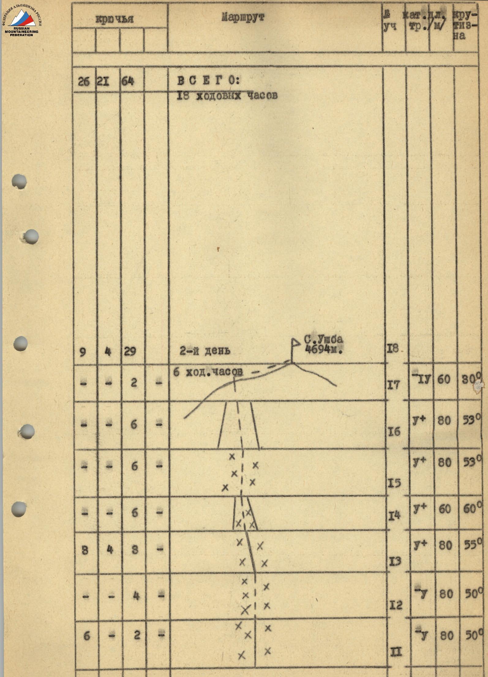
Pitons hammered: rock — 26 закладок — 21 ice — 64
-
Team's walking hours: 18 days: 2
-
Overnight stays: single overnight stay dug out on a snow-ice slope
-
Leader: Galkin S.P. — CMS Brynza A.A. — CMS Smirnov V.N. — CMS Krasavin V.I. — MS Mingalev V.N. — CMS Shemenev A.G. — CMS
-
Senior team coach: Khramtsova Galina Konstantinovna — Master of Sports of the USSR
II. Approach to the route — July 14, 1983 Summit — July 15, 1983 Return to camp — July 16, 1983
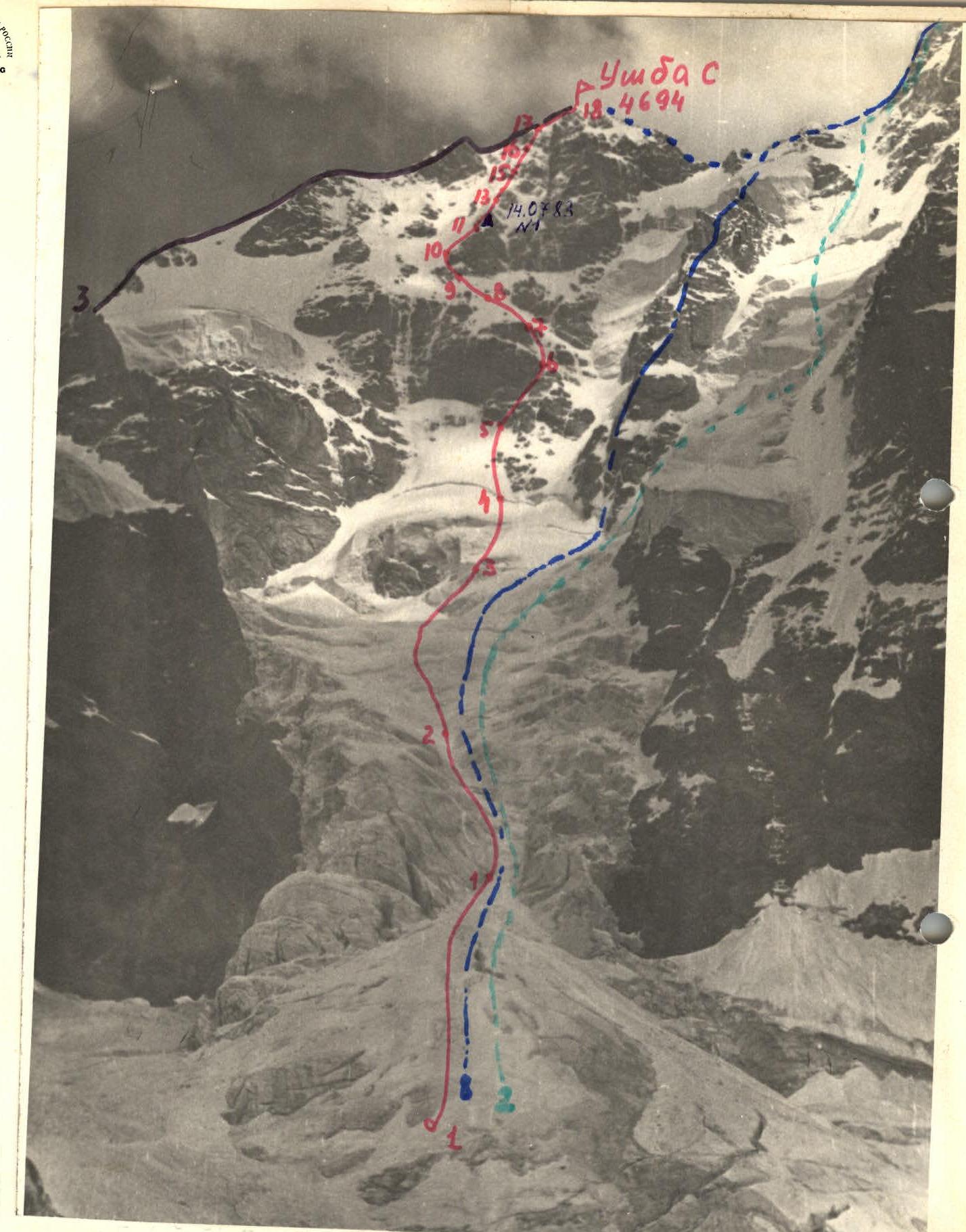
Photo # 1 — General photo of the summit Taken from v. Shkheldy V. H = 3400 m, June 25, 1983 at 14:00 Distance — 2.5 km Lens T-43 4/40 Point of shooting # 3
- M-t Kolomyttsev 1982
- M-t Cherevko 1982
- M-t via North ridge, 4A cat. diff.
- M-t Zhivlyuk 1962
- M-t Artsishevsky 1971
- M-t Grigorenko–Prigoda 1972
- M-t Myshlyaev–Kosmachov 1960
- M-t "Krest"
On July 12, 1983, at 10:00, the team left the "Adyr-Su" alpine camp along the Yusengi gorge towards Becho pass, then down to the "Beech Grove" overnight stay. On July 13, at 8:00, they departed from "Beech Grove" and by 12:00, the group stopped for a bivouac under the counterfort of v. Shkhelda East, opposite the planned route.
Throughout the day and evening, careful observation of the route was conducted, which led to the conclusion that the route was relatively safe in the near future. Therefore, it was decided to start the route according to the backup tactical plan, i.e., on July 14 at 3:00.
On July 14, 1983, the team rose at 2 a.m. and departed at 3:00. The transition across the glacier under the route took 30 minutes, with simultaneous movement in rope teams. Further, through the left part of the gully: – Movement upwards to the bergschrund — 2 hours 30 minutes. – Simultaneous movement in rope teams, belaying through ice screws. The first to move is the rope team Galkin — Smirnov on section R4–R5. – Simultaneous movement, belaying with ice screws. – Ice is brittle with a thin crust.
Section R5–R9. Change of leading rope team, Krasavin — Shemenev move forward. First, through the ice gully among rocks, then up a steep ice slope to the 2nd rock belt, at the base of which the first ascenders left a control cairn. Careful searches yielded no results. The group continues in the same order, moving along the route and, having passed section R9–R11, organizes a bivouac for two tents on a sharp snow ridge and an ice slope under a rock wall. At the bivouac site, a control cairn was left — a can with a note hung on a rock pit on the wall. Sections R5–R6, R8–R11, the 2nd and 3rd rope teams moved via fixed ropes.
July 15, 1983 — departure on the route at 9:00. Fog — visibility 30 m, the first to work is the rope team Brynza — Mingalev. Movement of rope teams remains simultaneous, belaying with ice screws. Periodically, rock pitons and chocks are used, hammered into individual rock outcrops. Movement occurs through a system of ice couloirs and ice-snow ridges. Moreover, as they approach the summit ridge, the amount of snow on the ice increases. For reliable belaying, it is necessary to clear the snow and screw ice screws into the bare ice. At 14:30, the group reaches the summit ridge in full and at 15:00 reaches the summit. Sections R14–R17, the 2nd and 3rd rope teams move via fixed ropes. The descent from the summit was organized via the 4A cat. diff. route. In 6 hours, the team stopped for a bivouac on the "Ushba cushion".
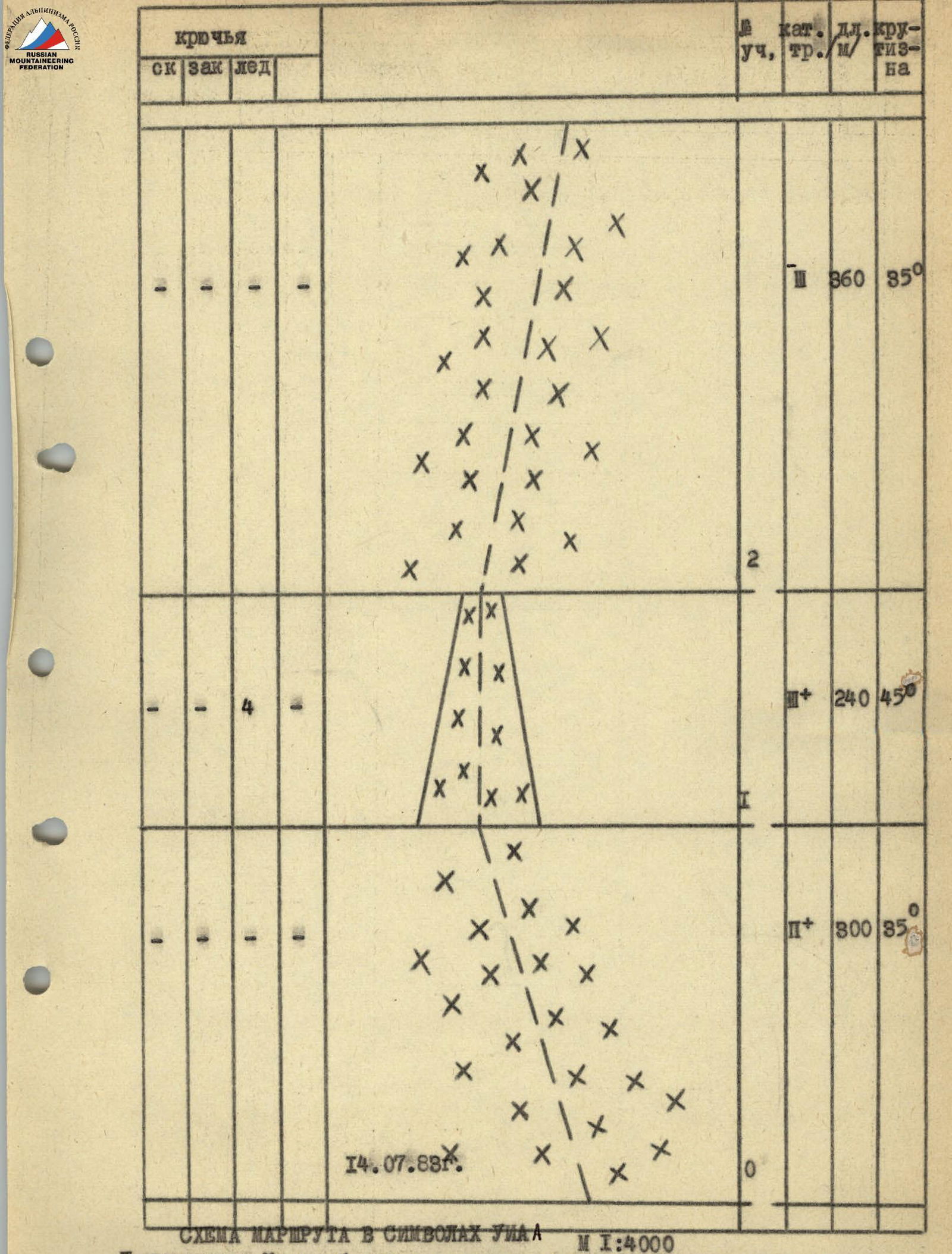
Note: The scale of the diagram has been altered due to the large length and uniformity of the terrain of the route sections.
Route description by sections
1st day — July 14, 1983
Section R0–R1 — Simultaneous movement along the huge snow-ice cone of the outflow towards the gully. Rope teams: Galkin — Smirnov, Krasavin — Shemenev, Brynza — Mingalev.
Section R1–R2 — Movement through the left part of the steep ice gully. On the steepest sections and when crossing crevices, belaying through ice screws.
Section R2–R3 — Movement along the snow-ice slope along avalanche outflows and remnants of ice collapses, in the direction to the right of the rock island into the ice gully leading under the large hanging glacier to the left of the "Krest". Movement of rope teams is simultaneous, belaying is carried out using ice screws.
Section R3–R4 — Steep ice gully, leading to the bergschrund, bypassing the rock island on the right. Movement is simultaneous with belaying through ice screws. The first to work is the rope team Galkin — Smirnov.
Section R4–R5 — Overcoming the bergschrund — a 5-meter overhanging wall is done with the help of ice axe and ice screw. Above the bergschrund, left-upwards to the base of the 1st rock belt along a steep ice slope. Movement remains simultaneous with belaying through ice screws.
Section R5–R6 — Change of leading rope team, Krasavin — Shemenev move forward. First, along the flow ice on rocks, then along a steep ice slope, bypassing the 1st rock belt. Belaying is carried out through ice screws, rock pitons, and chocks. The 2nd and 3rd rope teams move via fixed ropes.
Section R6–R7 — Steep ice-snow slope. Movement left-upwards towards a vaguely defined ridge. Rope teams move simultaneously with belaying through ice screws.
Section R7–R8 — Vaguely defined ice-snow ridge. Movement straight up towards the ice part of the 2nd rock belt. Rope teams move simultaneously. Belaying through ice screws.
Section R8–R9 — Steep ice slope leading to the base of the 2nd rock island. Rope teams move alternately, belaying through ice screws.
Section R9–R10 — Beginning of bypassing the 2nd rock island left-upwards along the ice gully. Rope teams move alternately, the 2nd and 3rd rope teams move along a fixed rope. Belaying is combined: ice screws, rock pitons, and chocks are used.
Section R10–R11 — Steep ice-snow slope. The general direction of movement is right-upwards to the base of the ice-rock ridge starting above the 2nd rock belt. The 2nd and 3rd rope teams move along fixed ropes, belaying was carried out through ice screws, rock pitons, and chocks. On the snow ridge and ice slope under the rock wall, we prepare places for two tents.
2nd day — July 15, 1983
Fog, visibility 30 m.
Section R11–R12 — The first to work is the rope team Brynza — Mingalev. Steep snow-ice ridge with rare rock outcrops. Movement is simultaneous with belaying through ice screws, rock pitons.
Section R12–R13 — Steep ice slope. Rope teams move simultaneously, belaying through ice screws.
Section R13–R14 — Steep snow-ice ridge with rare rock outcrops. Rope teams move simultaneously, using ice screws, rock pitons, and chocks for belaying.
Section R14–R15 — Steep ice couloir with flow ice. The 2nd and 3rd rope teams move along a fixed rope, belaying through ice screws.
Section R15–R16 — Steep snow-ice slope. The 2nd and 3rd rope teams move along a fixed rope, belaying through ice screws.
Section R16–R17 — Left-upwards along a snow-ice couloir with an exit to the ridge. The 2nd and 3rd rope teams move along fixed ropes, belaying through ice screws. When exiting to the ridge, there is a possibility of cornice collapse on the opposite side of the summit ridge.
Section R17–R18 — One and a half ropes along the ridge to the summit. The ridge is sharp with cornices, not difficult but dangerous. Belaying through ice screws, it is necessary to clear snow to ice.
Descent via the 4A cat. diff. route to the "Ushba cushion" took 6 hours. The fog greatly hindered visibility.