Ascent Logbook
- Ascent class — technical
- Ascent area — Central Caucasus, Prielbrusye
- Peak, its height, and ascent route — Bashkara (4241 m) via the North wall (Yu. Grigorenko-Prigoda route)
- Difficulty category — 5B
- Route characteristics: elevation gain: from Bashkara glacier — 920 m, from bergschrund — 670 m. average steepness: wall section — 62°, entire route — 50°. length of sections: 1st difficulty category — 0 m, 2nd difficulty category — 530 m, 3rd difficulty category — 175 m, 4th difficulty category — 300 m, 5th difficulty category — 290 m, 6th difficulty category — 110 m.
- Pitons used: for belaying — 50 rock, 12 ice, 1 drill piton; for creating I.T.O. — 14 rock. закладные элементы: 14 for belaying, 8 for creating I.T.O.
- Total climbing hours — 32 hours
- Number of overnight stays and their characteristics: lying — 1, semi-sitting — 2, sitting — 1
- Surname, name, patronymic of the leader and participants, their sports qualification: Gorodetsky Evgeny Mikhailovich — Candidate for Master of Sports Svitov Vyacheslav Mikhailovich — Master of Sports
- Team coach — Svitov V.M.
- Date of departure and return: departure — August 17, 1978, return — August 21, 1978
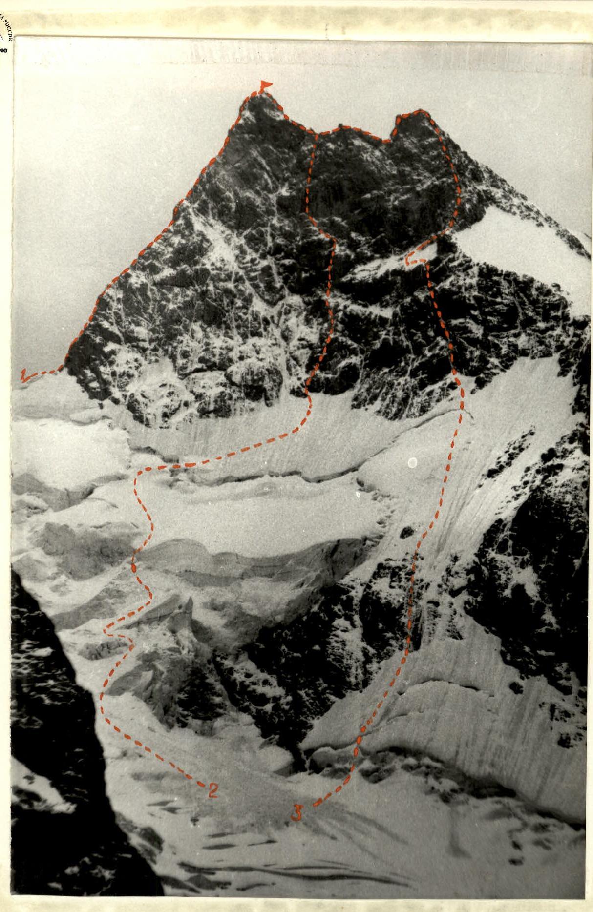
Bashkara (from the north)
- E. Ivanov's route — 3B via the NE ridge
- Yu. Grigorenko-Prigoda's route — 5B via the N wall (climbed by the group)
- V. Lifshits' route — 5B via the N wall of the western shoulder.
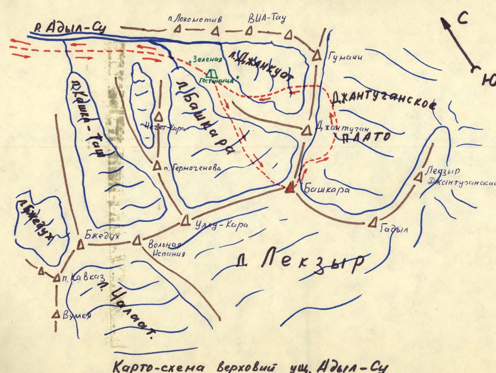
Schematic map of the upper Adyl-Su valley
Route Description
(explanation for the table)
On August 17 at 9:45, we departed from the bivouac on the moraine under the NW ridge of Mt. Jangutugan. Visibility was 200–300 m. We moved between two layers of clouds. Initially, we traversed the Bashkara glacier towards the col between Bashkara and Jangutugan, then turned right-upwards, bypassing the zone of ice avalanches on the left, and reached the bergschrund under the N wall of Bashkara. The glacier was heavily crevassed, and we navigated through the crevasses using bridges. We crossed the bergschrund in its left part via a narrow snow bridge and a 10-meter ice wall with piton belays. From the bergschrund, we ascended approximately 200 m upwards-right along a steep ice slope under the wall, heading towards a rock island to the right of a large couloir that runs through the entire wall. The movement was alternating with piton belays. Throughout the ascent under the wall, we experienced occasional rockfall. When crossing the couloir's neck, we were caught in a significant rockfall but fortunately escaped unharmed.
We continued by ascending a narrow ice couloir to the right of the rock island and then exited right-upwards onto destroyed, glaciated rocks with sections of "sheep's backs." We climbed 30 m up the backs and a wall to reach the base of a poorly defined, heavily destroyed internal corner, partially filled with frozen ice. The 45-meter ascent up the corner was very challenging, involving climbing under a rock overhang from which water continuously dripped. We navigated the overhang "head-on," using artificial holds. Above the overhang, we encountered a section of destroyed wet slabs with frozen ice, which we climbed with great difficulty for 45 m to reach the 1st terrace of the wall. By this time, the snowfall intensified, and rocks occasionally fell from the wall, shooting across the terrace. Therefore, despite the presence of a decent area on the terrace, we set up a bivouac under an overhanging ledge on the left side. The overnight stay was semi-sitting. At 19:00, a heavy snowfall with thunderstorms began, lasting throughout the night and most of August 18. During the night, three avalanches of fresh snow swept across the terrace, but the overhang provided good protection, and our bivouac remained unharmed.
By 15:00 on August 18, the snowfall had subsided. The condition of the route had significantly deteriorated. Everything was covered in a thick layer of snow. Descending became extremely dangerous and practically impossible due to the risk of avalanches on the ice sections. Therefore, we decided to continue the ascent. That day, we chose not to dismantle the bivouac and instead processed the beginning of the second ascent of the wall. From the bivouac, we moved 20 meters along the ledges to the left until the end of the terrace, reaching the base of an internal corner with a narrow slit; the upper part of the corner was overhanging. Water flowed through the corner, and there was much frozen ice. Navigating this section proved exceptionally challenging, requiring the use of artificial holds. After advancing 40 meters, we secured the rope and descended back to the bivouac by 19:00.
On the morning of August 19, there was a light snowfall, and it was very cold. After packing up the bivouac at 6:30, we continued on the route. We ascended via the secured rope using jumar clamps through the internal corner and reached a snow ledge. Along the ledge, we moved 30 meters upwards-left under a monolithic, steep wall entirely covered in frozen ice with snow adhering to it. 25 meters of very difficult climbing with artificial holds on the wall led us to the destroyed rocks of the upper terrace. The weather worsened, it became colder, and a blizzard began. After traversing 100 meters left-upwards across heavily destroyed, snow-covered rocks and ledges of the second terrace, we set up a sitting bivouac at the end of the terrace by 18:00. The snowfall ceased intermittently during the night, occasionally replaced by "graupel." It warmed up slightly by morning.
On August 20, after dismantling the bivouac, we began searching for a further path. Above the terrace, a wide belt of monolithic overhanging rocks was visible. On the left side, a narrow overhanging chimney was seen, transitioning into a cleft in its upper part. We decided to continue moving through the chimney. The section proved to be extremely challenging:
- The chimney walls were covered in ice;
- The cleft was partially filled with ice;
- We had to chop ice throughout the section and use artificial holds.
The weather improved slightly, with glimpses of the sun through the cloud breaks. The chimney and cleft, after 40 meters, led to very heavily destroyed "tiled" slabs covered in frozen ice and snow. This section was very complex and hazardous:
- Most holds were "reverse";
- Pitons in the destroyed tiles held poorly;
- We had to clear every meter of ice.
Therefore, the movement was very slow. After advancing 120 meters through this section, we reached the heavily destroyed summit ridge by 18:00, where we found a suitable area, pitched a tent, and set up a bivouac. During the night, there was a hurricane-force wind, a blizzard, and extreme cold.
On the morning of August 21, it was clear and frosty. We departed from the bivouac at 6:00 and initially followed a simple, destroyed ridge with snow sections, then descended a snow-ice couloir, reaching the summit at 8:00. The weather was sunny and warm. We began our descent via the 3B category route at 8:15. The entire route was snow-covered. No rappel loops were visible. Snow on the rocks was poorly adhered, so we had to organize about 20 rappels down to the Jangutugan plateau. Continuing our descent, we reached the "Green" hotel by 20:30, where we met the observation group.
Protocol
of the analysis of the ascent to Bashkara peak via the north wall, 5B category difficulty (Grigorenko-Prigoda route), undertaken by a group of instructors from the camp consisting of: Gorodetsky E.M. and Svitov V.M., on August 21, 1978.
Present: Head of the Training Department of "Adyl-Su" alpine camp, Master of Sports N.A. Kusel-Moroz, Head of the Rescue Team, senior instructor N.L. Shupilo, senior instructor, Master of Sports B.V. Savostyanov, senior instructor, Master of Sports V.V. Kisel, instructor, Master of Sports Svitov V.M., Candidate for Master of Sports Gorodetsky E.M., and observer Popova T.K. — 3rd sports category.
Gorodetsky: In accordance with the route sheet, on August 14 at 13:00, we departed from the camp and arrived at the "Green hotel" bivouac. There, we met observers from the "Elbrus" alpine camp, whose double team of instructors was on the same route, having departed on August 14. We contacted the group on the wall via radio, received consultation on the route conditions, and recommendations for the exit. We decided not to exit on the 15th due to the potential rockfall from the working group on the route.
On August 16, the "Elbrus" double team descended to the "Green" hotel in the first half of the day. After receiving detailed consultation from them, we departed for the overnight stays under the route at 12:00.
On August 17, visibility was 20 meters in the morning, with heavy fog, but by 9:00, visibility improved, and we departed on the route at 9:45. Visibility was about 600 m; we moved between two layers of clouds. After traversing the icefall, the zone of ice avalanches, and the bergschrund, we moved rightwards along steep ice to reach the beginning of the rock wall. While moving under the wall, we were caught in a significant rockfall but were unharmed. We began the ascent on the rocks at 13:00. After completing the first rock ascent, we reached the first terrace by 17:30 and set up a bivouac under an overhanging wall on the first terrace. In the evening, a heavy snowfall with thunderstorms commenced, lasting throughout the night and most of August 18. The entire wall was covered in continuous streams of "graupel," and avalanches of fresh snow began, overlapping our bivouac several times.
Only by 15:00 did the snowfall subside somewhat, and we processed 50 m of the second ascent, returning to the old bivouac. The condition of the route had become significantly more complicated: there was much frozen ice, all rocks were plastered with snow, water flowed down the wall, and streams of "graupel." We decided to continue upwards as descending became extremely dangerous due to continuous avalanches and very poor snow conditions. In the evening, we received a radio message about the extension of the control time.
On August 19, in poor visibility (20–30 m), we continued our ascent and completed the second rock ascent, reaching the second (upper) terrace, where we organized a sitting bivouac. On the same day in the evening, we processed the overhanging section of the third ascent.
On August 20, we continued our movement. The passage of the third ascent proved to be the most challenging and hazardous. All rocks were entirely covered in frozen ice and a layer of snow. The rocks were of a "tiled" structure and very fragile. Often, we had to use artificial holds. By 17:30, we reached the summit ridge and set up a bivouac on a suitable area. At 19:00, it became significantly colder, and a snowfall with a blizzard began.
On August 21, we reached the summit at 8:00 and began our descent via the 3B category route. The descent was also in very poor condition: all rappel loops were snow-covered and not visible. We had to organize new descent points. A total of about 20 rappels were organized. By 16:30, we descended to the Jangutugan plateau and reached the "Green hotel" by 20:30.
Kusel-Moroz: What is your assessment of the route, your opinion on your partner, was the equipment, food, and fuel sufficient?
Gorodetsky: The route was in the most challenging condition due to the bad weather, making it a very difficult 5B, close to 6th category difficulty. The route is quite hazardous due to the fragility of the rocks, spontaneous rockfalls, and the difficulty of organizing belays on certain sections. We worked alternately at the front, and both of us passed the key sections. My impression of my partner is very positive; we have been climbing together for 6 years, so there were no issues in this regard. We frequently used artificial holds and had to pull our backpacks. The food and fuel were sufficient, lasting until the last day.
The equipment included: two 45 m ropes, 20 carabiners, 30 rock pitons, 5 ice pitons, ladders, and jumar clamps. Radio communication was fairly stable. On the first day, the "Vitalka" radio's power source failed, but it was replaced with three batteries from flashlights. There were instances of radio failure among the observers as well.
On August 20 at 17:00, upon reaching the ridge, we warned that this would be our last radio transmission as we were leaving the radio visibility range.
Svitov V.M.: The "Elbrus" double team advised against departing on the 15th via radio. So, we departed on the 16th, after receiving their consultation and waiting for them to pass the route.
On August 16, we set up a bivouac on the moraine an hour's walk from the "Green hotel." On the 17th morning, there was fog with no visibility, but we reported via radio that we were waiting. By 9:00, the cloud cover broke, and we reported at 10:00 that we had departed on the route. The approach under the wall went well until the upper part; the ascent via the gully was straightforward. The previous group recommended, based on their reconnaissance, to traverse almost to the col and then rightwards. The snow on the approach was very challenging. After the bad weather, we decided to continue up the route as descending presented a much greater danger. As a backup plan, we considered transitioning rightwards to the simpler Lifshits route, but during the ascent, we decided to stick to the planned route. The climbing conditions were winter-like. Fatigue was a factor. Before reaching the ridge, we somewhat overestimated our strength, saying on the radio that we would be on the summit that day. The last 100 meters of the wall were very challenging, taking 4 hours to climb. When we reached the ridge, we unexpectedly found a suitable area and pitched a tent. An early departure the next day was not possible due to being very wet, and there was a severe frost before dawn. From the bivouac to the summit was 3.5 rope lengths. We reached the summit at 8:00.
On the descent, we also underestimated the condition of the 3B category route. No loops were visible; everything was under snow. Additionally, following the "Elbrus" group's recommendation on the descent, we deviated somewhat to the right from the correct path. We had to make diagonal rappels (20 descents) towards the col. We rappelled down to the plateau with thorough belaying, as the snow on the rocks did not hold at all. We left all auxiliary materials — cordelettes, auxiliary ends, and 26 pitons — on the descent.
My impression of my partner: I am very glad to have climbed with him since 1973; I am satisfied with him in all respects, both as a person and as an athlete. The ascent was very challenging, especially difficult in such conditions as a double team. The equipment was well-suited; the tent was light (1 kg with poles), and the assortment of pitons and chpitons and slings was well-chosen.
Popova T.K.: Planned radio communication was on even hours. On the third day of the ascent, there was a failure in one communication session. On the 20th, the "Vitalka" radio failed, working only on receive, but we received information from the group and relayed it to the camp. New batteries were brought from the camp, but this did not help. The last communication with the group was on August 20 at 17:00. The message was: "We are on the ridge, setting up for the night. See you back home."
On August 21, from the moraine, I observed the summit through binoculars at 6:00 but did not see the group. The camp instructed us to attempt to contact the group hourly and observe their descent path. Additional communication with the camp was scheduled for 20:30. After 18:00, I went to the moraine and spotted a trail on the Jangutugan pass at 18:30, reporting this to the camp. Then, through binoculars under the rocks of Aristov, I saw the trail and the descending double team. I met them at 20:00 on the moraine of the Jang-kuat glacier. By 20:30, the group was at the "Green" hotel.
Kisel V.V.: Your mistake was not checking in via radio from the summit and during the descent on August 21.
Kusel-Moroz N.A.: The route was climbed correctly and competently. The decision to continue upwards after the bad weather was correct. The delay on the descent is explained by the poor condition of the route. At 16:00, we decided to send a group to meet you via the 3B category route for liaison and visual observation, but this was not necessary. The observers deserve thanks; the communication with the group and the camp was very well organized. The ascent is confirmed; I congratulate the group members.
Secretary of the analysis — (signature) Svitova T.V.
The analysis was conducted by the Head of the Training Department — (signature) N.A. Kusel-Moroz.
Copy of the analysis is true. Head of the Training Department (signature) Akb.