SPORTING AND TECHNICAL CHARACTERISTICS OF THE ASCENT OBJECT Khimik 5AK to the S wall with crest

The "Khimik" peak (3935 m) is located on the western spur of the "Adyr-Su" peak. There are two routes to the summit. The first ascent of "Khimik" was made by a group led by Yuryev A. on August 15, 1951, during the traverse of Khimik—Treugolnik.
The ice and snow slopes of "Khimik" towards the "Yunom" glacier end in sheer walls of the Northern tower. In 1971, a group led by Naumov A. laid a 4B category route along the left edge of this tower.
In 1980, a group led by R. Efimov passed a route along the North-Eastern wall of the right edge of the Northern tower. In the upper part of the route, not noticing a simple exit to the right edge, the group:
- traversed along a ledge to the left under a large cornice;
- ascended to the Northern tower along the wall between the left and right edges.
The second passage of the route was made in 1981 by the duo Gnaevsky—Bratsev. This group reached the edge at the level of the traverse of the first ascenders and ascended to the Northern tower along it. The further path of both groups coincided with the 4B category route.
In this report, the sports group from "Dzhailyk" alpine camp describes the path taken along the variant of the second ascenders. We consider this path more logical and safer. During the ascent, the group observed rockfalls passing along the upper part of the path of the first ascenders.
The group evaluates the laid path as a 5B category route. Two groups that passed this route before us share the same opinion. In terms of the length of sections with 5th–6th categories of difficulty, the new route on "Khimik" corresponds to the 5B category rock routes on the "Dzhailyk" peak and significantly exceeds all 5A category routes in this area.
June 21
The group left the "Dzhailyk" camp at 12:00. Approaching the lower Kichkidars bivouac at 14:30, they set up a bivouac. Then the route was examined, but the planned processing of the route could not be carried out due to the very poor condition of the snow.
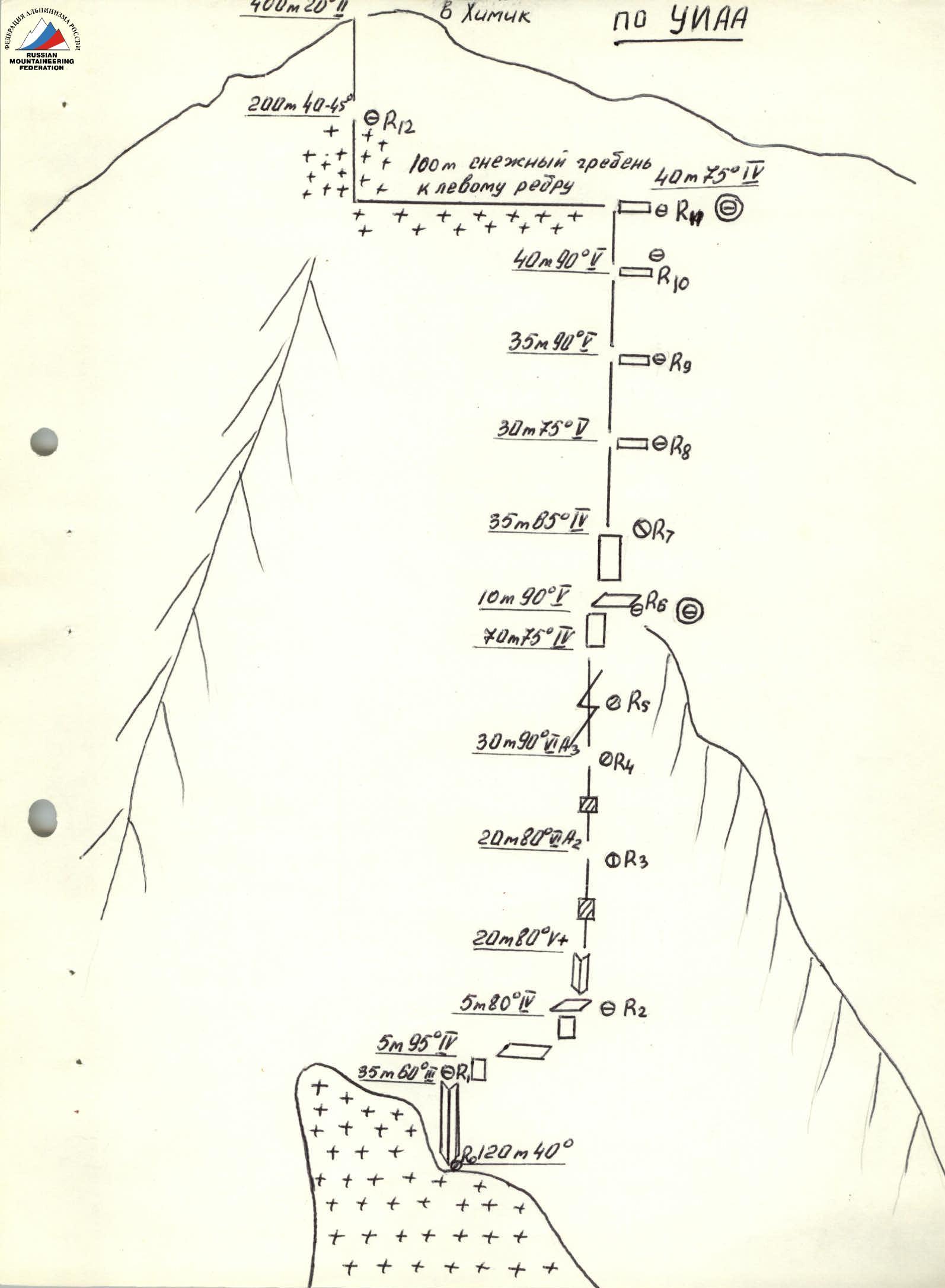
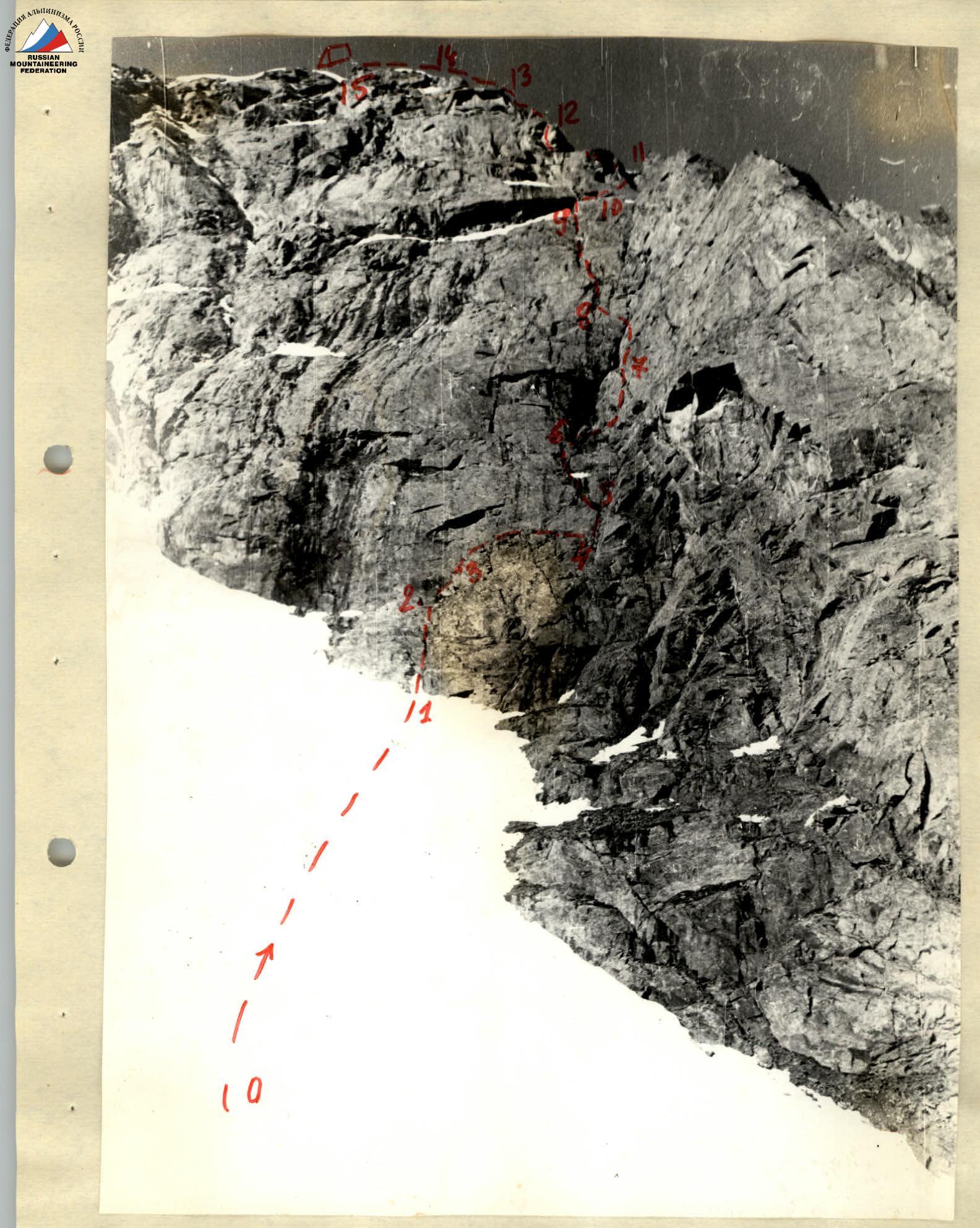
June 22. At 6:00, the group left the bivouac and, passing a snowy slope (section R0–R1), began work on the rocks at 8:00. The destroyed internal angle (section R1–R2) was covered with ice. During its passage, Sinitnikov, who was leading, hammered in the first rock pitons for belay. From a convenient belay ledge, through an overhanging rock (section R2–R3) with large holds, Melnikov V. first reached an inclined ledge with a large stone lying on it.
From the end of the ledge, along a steep slab (section R4–R5) with a limited number of holds, Melnikov reached a small inclined terrace, where he organized a station with three pitons. From here, the further path along the wall to the exit to the buttress is visible.
The route passes along a large internal angle that cuts through the wall. In the middle part of the internal angle, on the left side, a cornice overhangs.
Melnikov, wearing galoshes, passes 20 m along the internal angle (section R5–R6), then moves to its right edge and overcomes the next path (section R6–R7) with the help of ladders.
Melnikov works on a double rope:
- one of them he clips into pitons hammered into the left edge of the angle;
- the other — into pitons hammered along the crack on the right edge of the internal angle.
Having secured one rope as a handrail, Melnikov organizes belay for Sinitnikov, who is following, and who removes all intermediate pitons and pulls a third rope for belay for the third climber. Volenyuk S. also moves along the handrail with top belay and pulls out the rope for belay for the last one. Ivchik V. removes the lower station, unties the knots at the lower end of the handrail, and ascends.
Further, the entire path to the bivouac on the ridge was passed by the group according to the described scheme, changing the leader. Melnikov V. and Sinitnikov N., wearing galoshes, were the first to work on the wall. The weight of the first climber's backpack was 5 kilograms.
From an inconvenient ledge, Melnikov began to bypass the cornice to the right along a wide crack (section R7–R8). The lack of holds did not allow passing this section by free climbing, so the first climber overcame the section on ladders, using a wide range of placements.
Having passed the crack, Melnikov reached a narrow ledge under the cornice. Here, on a piton in a "control tour" cairn, the group replaced the note of the second ascenders (Gnaevsky—Bratsev).
Further, the group moved:
- along a crack passable by free climbing (section R8–R9);
- through a ten-meter sheer wall (section R9–R10) and reached a convenient ledge on the right edge.
10 m below along the edge, traces of the bivouac of the duo Gnaevsky—Bratsev are visible.
Further along the damp slabs of the ridge section R10–R11 to an inconvenient ledge on the edge, Sinitnikov moves first, then he passes along the steep rocks of the ridge section R11–R12 to a narrow long ledge above the passed wall. The sheer ascent of the ridge (section R12–R13) is overcome by Sinitnikov along the yellow rocks on the left side of the outer angle. The group members had to use jammers when passing this section. The next sections of the ridge (section R13–R14) were first passed by Volenyuk. The ridge consists of short 5–7 m walls with small ledges between them.
Having overcome this section, the group set up a bivouac in a snow couloir at 18:00.
June 23
At 6:30, the group left the bivouac and approached the base of a snow "knife" along simple snowy slopes (section R15–R16), along which the route along the Left edge of the Northern tower of 4B category passes.
Along the snow "knife", turning into an ice wall (section R16–R17), the group ascended to the "cushion" of the ice fall of the Northern ridge. At 10:00, along the snowy Northern ridge, the group reached the summit of Khimik.
The descent was made along the following sections:
- Eastern ridge;
- couloir to the Severny Adyr-Su glacier;
- trail through Mestia bivouacs.
At 14:00, the group returned to the "Dzhailyk" alpine camp.
| Section | Characteristics | Pitons | Steepness in degrees | Length in meters | Category of difficulty |
|---|---|---|---|---|---|
| R0–R1 | Snowy slope | 40 | 120 | 3 | |
| R1–R2 | Internal angle | 4 | 65 | 35 | 3 |
| R2–R3 | Overhanging rock | 1 | 95 | 5 | 4 |
| R3–R4 | Ledge | 20 | 15 | 2 | |
| R4–R5 | Slab | 1 | 80 | 5 | 4 |
| R5–R6 | Internal angle | 3 | 80 | 20 | 5 |
| R6–R7 | Bypass of internal angle | 8 | 90 | 20 | 6 |
| R7–R8 | Bypass of cornice | 9 | 90 | 30 | 6 |
| R8–R9 | Flat crack | 8 | 75 | 70 | 4 |
| R9–R10 | Wall | 5 | 90 | 10 | 5 |
| R10–R11 | Slabs (damp) | 3 | 65 | 30 | 4 |
| R11–R12 | Ridge | 5 | 75 | 30 | 5 |
| R12–R13 | Ascent of ridge | 6 | 90 | 35 | 5 |
| R13–R14 | Ridge | 8 | 75 | 40 | 5 |
| R14–R15 | Stepped ridge | 5 | 75 | 40 | 4 |
| R15–R16 | Snowy slope | 20 | 100 | ||
| R16–R17 | "Knife" | 5 | 45 | 280 | |
| R17–R18 | Ridge (rocky) | 20 | 200 | 2 |
Explanations for the table:
- R0–R1: Steep snowy slope.
- R1–R2: Destroyed internal angle with ice.
- R2–R3: Overhanging rock with large holds.
- R3–R4: Ledge with grass.
- R4–R5: Slab with smooth holds.
- R5–R6: Damp internal angle.
- R6–R7: Bypass along a crack, artificial holds.
- R7–R8: Wide crack — bypass of cornice.
- R8–R9: Wide, destroyed, damp crack.
- R9–R10: Wall with small holds.
- R10–R11: Slabs of the ridge.
- R11–R12: Ridge with small holds.
- R12–R13: Ascent of ridge.
- R13–R15: Stepped ridge, with individual sections of 2–5 m with very tense climbing.
Wall part of the route. Route profile