Passport
- Type of ascent — ice and snow climb.
- Region of ascent — Central Caucasus, Main Caucasian Range, Adyr-Su valley.
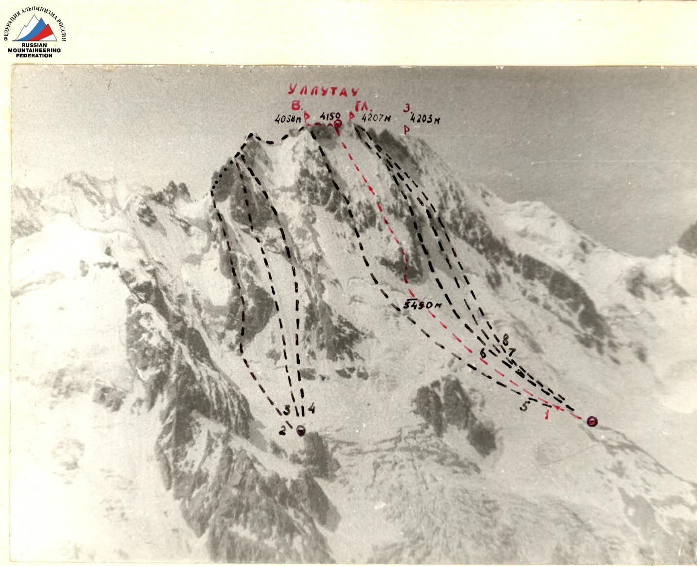
- Peak, its height, ascent route — Ullutau East, 4058 m, via rocky outcrops of the North face, West ridge (route by Yu. Chernoslvin, 1965)
- Difficulty category — 5B
- Route characteristics:
- height difference of the route — 650 m
- route length — 850 m
- length of sections category 5 — 85 m (central part of the Big rocky outcrop)
- length of sections category 3–4 — remaining part of the rocky outcrop
- length of sections category 4–5 — 700 m (snow-ice slope)
- average steepness of rocks — 70°
- average steepness of snow-ice slope — 50°
- average steepness of the route — 52°
- Number of pitons:
| rock | bolt | chocks | ice screws |
|---|---|---|---|
| 26 | 0+2ˣ | 18 | 130 |
x — use of previously driven pitons.
- Number of climbing hours — 16 (not counting descent time)
- Number of bivouacs and their characteristics: one lying bivouac on the ridge
- Leader: SHKARBAN Viktor Vladimirovich Master of Sports of the USSR
Team members:
- EFIMOV Viktor Borisovich Master of Sports of the USSR
- KUROCHKIN Alexander Georgievich Candidate for Master of Sports
- SEKACHEV Nikolai Gennadievich Candidate for Master of Sports
- MINGALEV Vladimir Nikolaevich Candidate for Master of Sports
- TENENEV Valentin Alekseevich Candidate for Master of Sports
- Team coach: SHEVCHENKO Nikolai Alekseevich Master of Sports of the USSR
- Departure to the route — July 23, 1985 Summit — July 23, 1985 Return to the alpine base — July 24, 1985
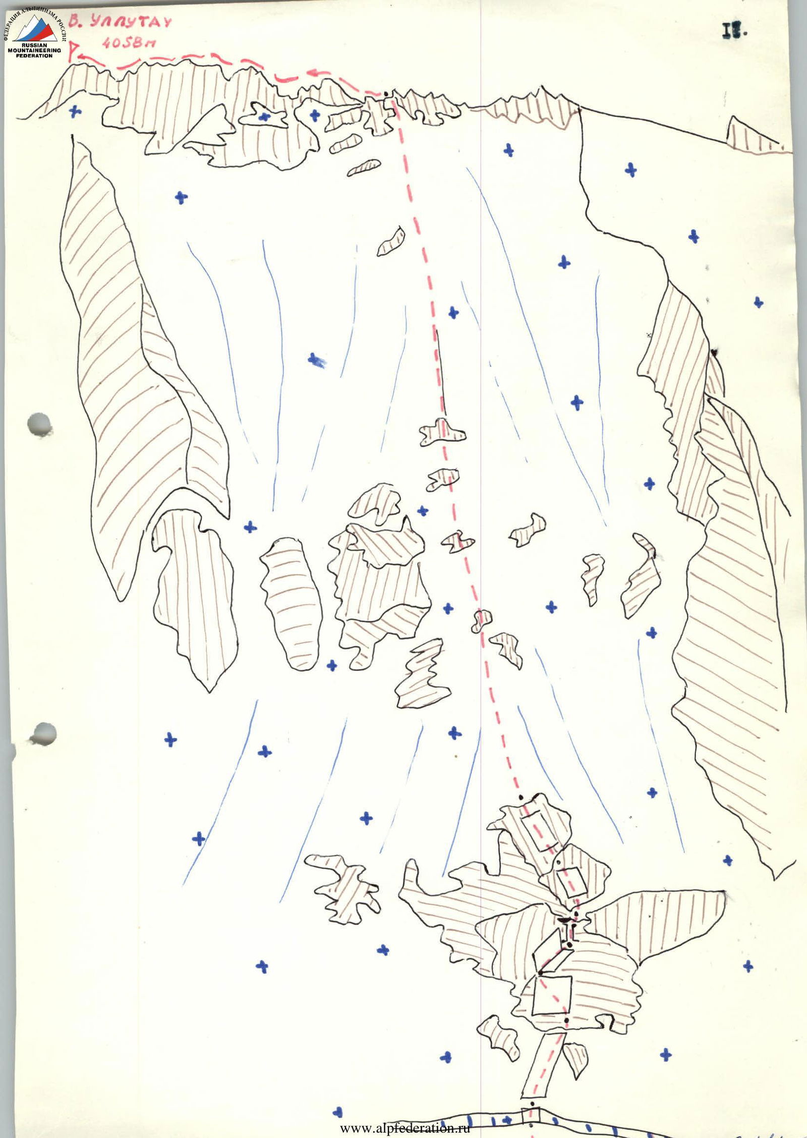
General photo of the summit.
- "Central bivouacs"
- "Naumov's bivouacs"
- Route of the RSFSR-2 team
- Bivouac on the ridge 1 — Ullutau E. via rocky outcrops of the N face and W ridge, 5B difficulty category (Yu. Chernoslivin, 1965) 2 — Ullutau E. via NE edge of the E shoulder, 5B difficulty category (A. Naumov, 1966) 3 — Ullutau E. via N face of the E shoulder, 5B difficulty category (Yu. Chernoslivin, 1959) 4 — Ullutau E. via right edge of the N face of the E shoulder, 5B difficulty category (V. Artamonov, 1979) 5 — Ullutau E. via right edge of the N face, 5B difficulty category (E. Manucharov, 1954) 6 — Ullutau Main via N face, 5B difficulty category (V. Abalakov, 1951) 7 — Ullutau Main via rocky outcrops of the N face and W ridge, 5B difficulty category (V. Maltsev, 1971) 8 — Ullutau Main via NNW face, 5B difficulty category (V. Li, 1981)
According to the tactical plan, the group departed from the "central bivouacs" on July 23, 1985 at 3:00 AM. They approached the key rocky section of the route at dawn at 6:00 AM. The pair: Kurochkin—Teneniev, alternating lead, climbed 85 m of complex rocks (section R2–R5), using 22 pitons and chocks. Section R5–R7 was climbed by Shkarban—Efimov, using 2 chocks and 9 rock pitons. Further movement (section R7–R8) was done on fixed ropes. The first climber used an ice axe and ice screws. Ice screws were screwed in approximately every 8 m. Everyone took turns being the first climber.
They reached the ridge at 5:00 PM. Leaving their backpacks on the ridge, the team climbed to the summit of Ullutau East, reaching it at 7:00 PM. At 8:00 PM, they returned to their backpacks and set up a tent.
Thus, the first day of the ascent went according to the tactical plan. By evening, the weather began to deteriorate: snow started falling, and the wind picked up.
The next day made adjustments to the tactical plan. We were delayed at the bivouac until 10:20 AM, waiting for the Kemerovo team with whom radio contact was lost. Radio contact at 10:20 AM was not established, and we, taking down the tent, moved towards the East peak of Ullutau to join the Kemerovo team and descend together. We met the Kemerovo team at the bivouac near East Ullutau.
The bad weather, which continued throughout the night and did not subside during the day, a large amount of snowfall, and the avalanche danger of the Garvash pass forced us to start descending via a simpler and safer route to the Mestia pass. We reported this via radio communication at 12:10 PM.
We started descending at 12:20 PM, and by 7:00 PM, we were at the Mestia pass. At the Ullutau alpine base — 9:30 PM.
Safety measures on the route included:
- early departure to the route, minimizing rockfall and avalanche danger;
- the first climber using a double rope;
- use of a shock absorber by the first climber;
- changing the lead climber every 40 m to avoid overloading the first climber;
- during the onset of bad weather — descent via a shorter, simpler, and non-avalanche-prone route;
- reliable radio communication;
- presence of other groups in the area.
July 23, 1985.
R0–R1 Bergschrund 10 m, steepness of the wall 80°, category 1. Passed on a double rope, belay was done using ice screws, the rest of the team passed this section on fixed ropes with top belay. R1–R2 Snow-ice slope 90 m, 50°, category 1. 7 ice screws were used during the passage. R2–R3 Climbed by the pair Teneniev—Kurochkin. Rocks like "ram's foreheads" are strongly smoothed, 40 m, 60°, category 1, 4 rock pitons, 4 chocks. The first in the pair climbed with a shock absorber on a double rope. R3–R4 "Rock wall with a small number of holds" 40 m, 80°, category 1. Kurochkin led, using:
- 6 rock pitons
- 4 chocks. R4–R5 "Chimney" 5 m, 90°, category 1, climbed free solo. 2 rock pitons were driven during the passage. R5–R6 "Rocks" 20 m, 50°, category 3–4. 5 rock pitons were driven. R6–R7 "Rock wall" 40 m, 45°, category 3–4. 4 rock pitons were driven and 2 chocks were used. R7–R8 Snow-ice slope with several short difficult rocky outcrops 600 m, 50°, category 4–5. 120 ice screws, 8 chocks, and 5 rock pitons were used during the passage. On this section, all team members took turns being the first climber, with the first climber belayed through a separate piton. R8–R9 Rocky ridge 500 m long, 0°, category 3–4. Climbed in pairs with alternating and simultaneous belay using rock features.
Ullutau East via rocky outcrops of the North face and West ridge (Chernoslvin's route)
From the "Central grounds" follow the broken Ullutau glacier to the large rocky outcrop at the lower part of the North face between the East and Main peaks of the Ullutau massif.
From the glacier, overcoming the bergschrund, ascend the steep 90–100-meter snow-ice slope to the center of the lower Big rocky outcrop.
Then:
- climb the difficult rocks of the 120–140-meter vertical wall of the outcrop with a small number of uncomfortable holds and cracks (bolts, ladders, ITO);
- further, climb 120–140 m of steep smoothed rocks at the upper part of the outcrop, alternating with steep snow-ice sections;
- reach the summit of the lower Big rocky outcrop.
From it, ascend a steep snow-ice slope to a small platform below the vertical wall of the small outcrop. The platform has a bivouac site.
From the bivouac, climb 600–650 m straight up the steep snow-ice slope with several short difficult rocky outcrops in the lower part, below the rocky belt of the main ridge of the massif. Climb the snowy rocks of average difficulty with short sections of above-average difficulty, 40 m up to the ridge of the Ullutau massif between the East and Main peaks. Then, move left along the West ridge to ascend the East peak.
Descent via the Main peak to the Garvash pass on route 4A category.