Ascent Passport No. 121
- Technical class.
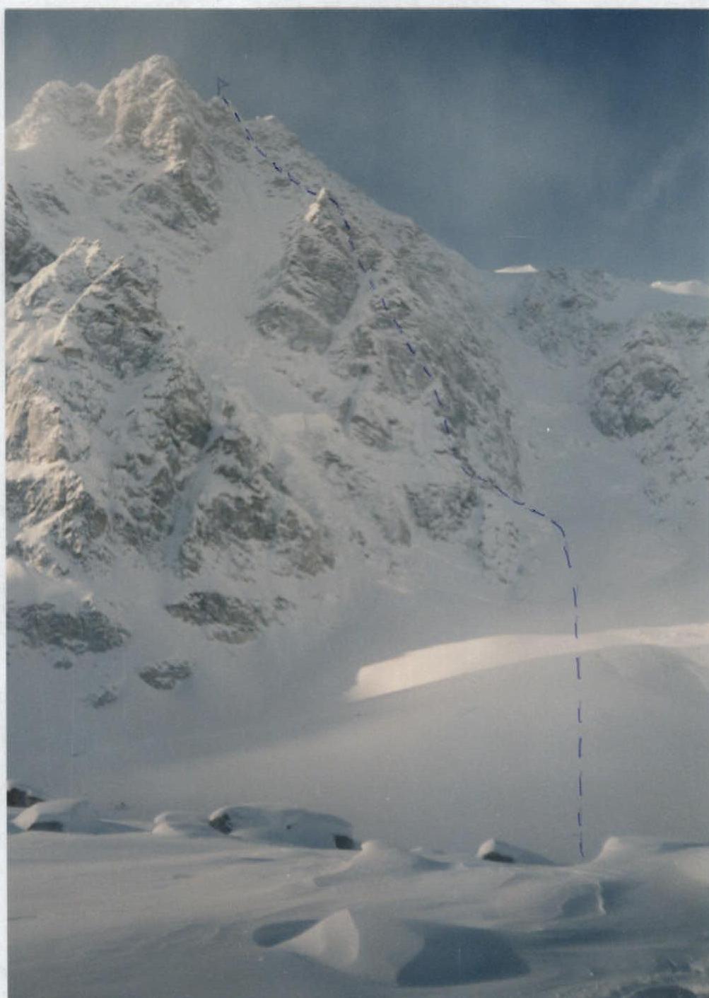
- Central Caucasus, Tyutyu Su gorge.
- Tyutyu 2nd Western peak via the northern wall (M. Khergiani route).
- Category of difficulty: 6A.
- Height difference — 1150 m, length 1800 m, of which 5th and 6th category of difficulty are 720 m.
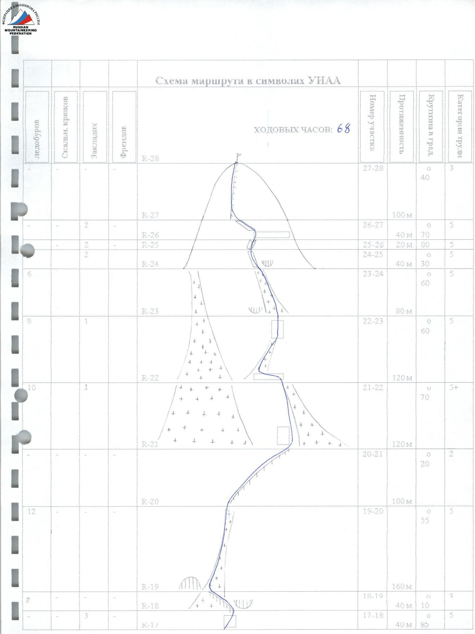
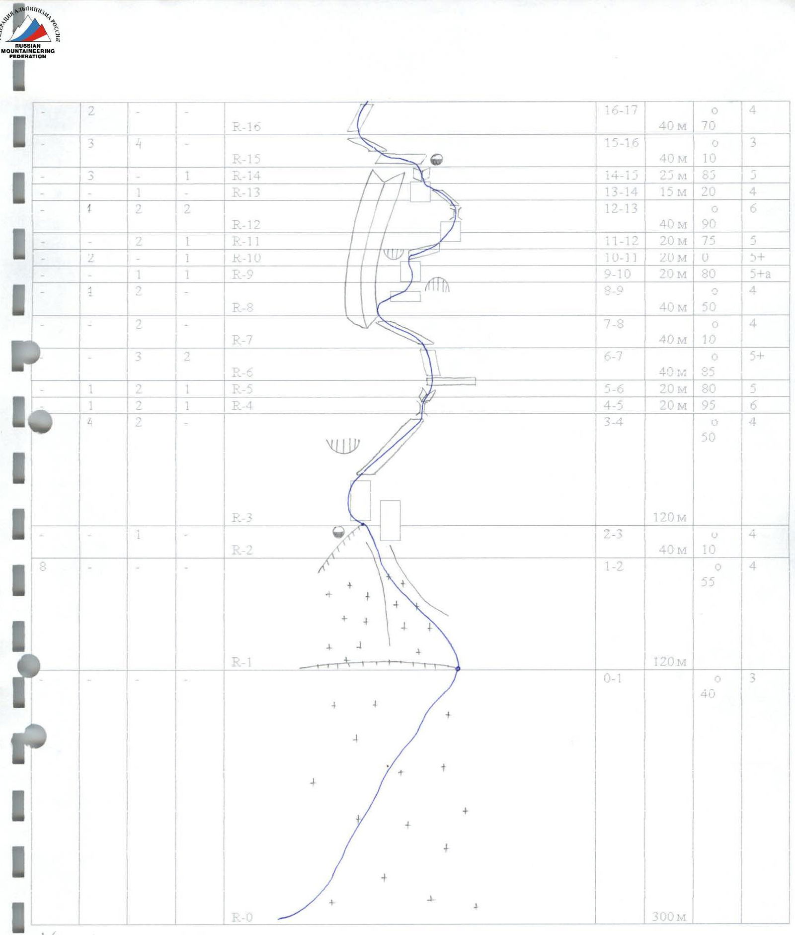
- Pitched:
| Ice screws: | Rock pitons: | Nut placements: | Cams: |
|---|---|---|---|
| 46 | 18 | 35 | 5 |
- Team's climbing hours — 68 hours; 4 days.
- Overnights: on the shoulder — 1, on the ledge — 2.
- Participants: Gazeev Andrey Valentinovich — Candidate for Master of Sports, leader, instructor 3rd category. Mokrushin Dmitry Vasilievich — Candidate for Master of Sports, coach, instructor 3rd category. Selivanov Valery Valentinovich — Candidate for Master of Sports, instructor 3rd category.
- Coach: Mokrushin Dmitry Vasilievich — Candidate for Master of Sports.
- Departure to the route: February 8, 2003. On the summit: February 10, 2003. Return to Neutrino: February 12, 2003.
- Team of the Rostov City Youth Public Organization Federation of Alpinism and Rock Climbing.

Tactical actions of the team
February 7: the team left the Neutrino settlement for the Tyutyusu gorge. At 18:00 at the initial bivouac.
February 8: departure from the bivouac at 7:00, on the shoulder at 12:00. Overcoming deep steep snow of the glacier (500 m). Arrival at the shoulder. Selivanov organized the bivouac, Gazeev and Mokrushin went to process the route, and by 17:00, 240 m of the route were processed.
February 9: departure from the shoulder to the ledge at 9:00. Quickly ascending the processed ropes, Gazeev continued to work on the route. The use of a Grigri allowed Andrei to ascend the route faster than we had calculated in Rostov. At 13:00 on the ledge, with subsequent processing of 160 m. In the evening, due to a noticeable increase in wind, a drop in temperature, and the onset of snowfall, we decided to continue the ascent in a rope team of Gazeev and Mokrushin. Phone communication was established, allowing Selivanov to control the rope team throughout the ascent to the summit.
February 10: the weather remained the same, and the rope team Gazeev and Mokrushin ascended to the summit. At 13:30 — on the summit. A note was not found; they left their own note on a screwed ice screw. Descending via the ascent route and with slightly improved visibility allowed Gazeev and Mokrushin to descend by 18:00. Some ropes were left on the route.
February 11: descent via the ascent route with an overnight stay in the kocho. Due to the abundance of fallen snow, they approached the kocho by 17:00.
February 12: at 12:00 — in Neutrino. Due to the abundance of snow, the control cairns were not found. A note on the summit was not found.
Equipment and gear:
- Footwear: "Koflach" and "Asolo" plastic boots
- Communication: "Megafon" phones
Description of the route by sections
First day, February 8, 2003
- R0–R1: snow-ice slope, simultaneous movement, 300 m;
- R1–R2: bergschrund and further steep snow-ice slope, insurance through ice screws, direction of movement into the narrowing couloir, 120 m;
- R2–R3: traverse left along the ledge covered with snow, insurance through ice axes, exit to the shoulder, 1st overnight stay, 40 m.
Second day, February 9, 2003
- R3–R4: rocks of moderate difficulty, along heavily snow-covered ledges to the right upwards to the base of the chimney, insurance for ledges, pitons, nuts, 120 m.
- R4–R5: difficult overhanging chimney, nuts, pitons, cams, 20 m.
- R5–R6: inner corner, exit to the right onto the ledge, pitons, nuts, cams, 20 m.
- R6–R7: smooth slab with a crack, cams, nuts, 40 m.
- R7–R8: traverse left to the base of a huge inner corner, insurance for ledges, nuts, 40 m.
Processed on the first day
- R8–R9: snow-covered rocks of moderate difficulty on the right side of the corner to the "tooth", nuts, pitons, ledges, 40 m.
- R9–R10: above the "tooth" smooth wall with a bolt, exit under an overhanging rock, nuts, cams, 20 m.
- R10–R11: traverse to the right to bypass the overhang, pitons, cams, 20 m.
- R11–R12: wall, exit to the right onto a snow-covered ledge under the cornice, nuts, cams, 20 m.
- R12–R13: difficult bypass of the cornice on the right and further wide chimney with a small number of holds, pitons, nuts, cams, 40 m.
- R13–R14: traverse left along the ledge, insurance for ledges, nuts, 15 m.
- R14–R15: wall (frozen live rocks), through a chimney (4 m) exit onto a wide snow-covered ledge, pitons, cams, 2nd overnight stay, 25 m.
Third day, February 10, 2003
- R15–R16: traverse left along the snow-covered ledge, insurance through ice axes, nuts, pitons, 40 m.
- R16–R17: gentle rocks filled with ice and snow on the right side of the couloir, pitons, 40 m.
- R17–R18: difficult wall with a small number of holds and an overhang in the upper part is bypassed on the left, exit onto a simple snow ridge, nuts, 40 m.
- R18–R19: simple snow ridge, simultaneous movement, ice screws, 40 m.
Processed on the second day
- R19–R20: from the ridge exit to the right into a long snow-ice couloir, insurance through ice axes, ice screws, 160 m.
- R20–R21: simple snow ridge leads under a rock slab, 100 m.
- R21–R22: the slab is bypassed on the right, then ascent along a steep snow slope turning into a snow-ice couloir. In the upper part (3 m) — chimney, ice screws, nuts, 120 m.
- R22–R23: from the chimney to the left, traverse 10 m, exit onto a wide ice-snow slope, ice screws, nuts, 120 m.
- R23–R24: along a narrow ledge (heavily filled with snow) cross the wall from left to right and further ascent along the snow slope under the overhanging wall, ice screws, 80 m.
- R24–R25: under the overhang pass to the left along the ledge to a small inner corner, nuts, 40 m.
- R25–R26: narrow steep snow couloir directed to the left, exit onto the pre-summit ridge, 20 m.
- R26–R27: along the icy couloir exit onto the ridge, 40 m.
- R27–R28: simple snow-covered ridge leading to the summit, 100 m; insurance on ice axes.
On the summit on February 10, 2003.