Passport
- Rock class.
- Western Caucasus (from Nakhar Pass to Chipperazau Pass).
- B. Nakhar (3780 m) via the northwest wall.
- Category 6B difficulty.
- Height difference: 1000 m, length — 1355 m.
The average steepness of the route is 75° (see sheet 3, front side). Length of sections: 150 m — category 6, 330 m — category 5, 400 m — category 4, 210 m — category 3, 250 m — category 1. 6. Pitons hammered in:
| For belay | For creating artificial anchors | |
|---|---|---|
| rock | 132 | 3 |
| chocks | 62 | 14 |
| bolt | (4 previously used) | 43 |
| ice | 6 | — |
- Team's walking hours: 21 hours and days — 2.
- Number of overnight stays: 1 (one convenient).
- Coach: Andryushchenko Anatoly Viktorovich — Master of Sports of the USSR.
- Captain: Chuenko Sergey Antonovich — Candidate for Master of Sports.
Team members:
- Fursov Yuri Sergeevich — Candidate for Master of Sports
- Plyasov Alexander Grigorievich — Candidate for Master of Sports
- Nedelkin Vladimir Ilyich — Candidate for Master of Sports
- Departure to the route: July 26, 1984. Summit: July 27, 1984. Return: July 27, 1984.
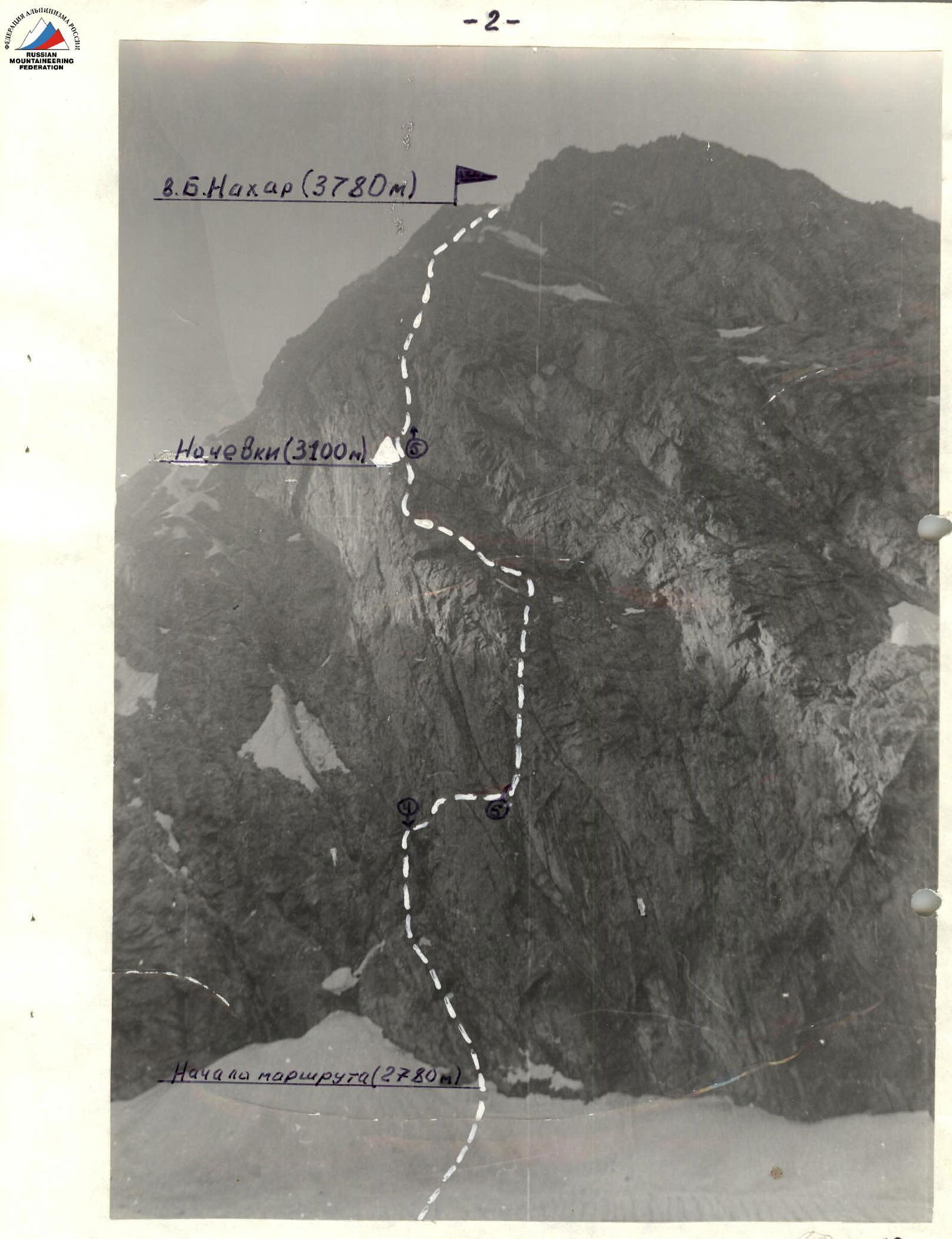
General photo of the summit of B. Nakhar (NW wall). Photo #3
- group's ascent path
- overnight stay (3100 m) on the route
- (3) — camera location on the area diagram (see sheet 3, back side). Date taken: July 24, 1984, Smena, lens 7–43, f=405 = 1200 m, camera height — 2700 m.
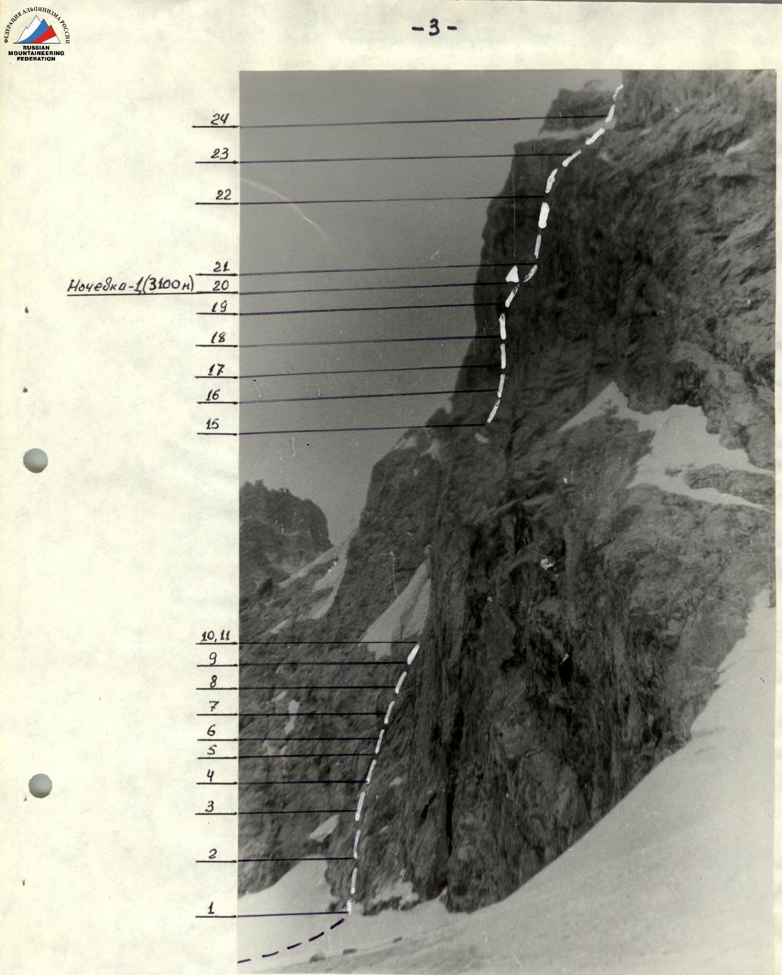
Photo #2
The wall profile on the right is the visible part of the route taken by the team.
1–24 — route section numbers.
(2) — camera location on the area diagram (see sheet 3, back side). Date taken: July 28, 1984, FED-3, lens I-61, f=52 mm, =900 m, camera height — 2500 m.
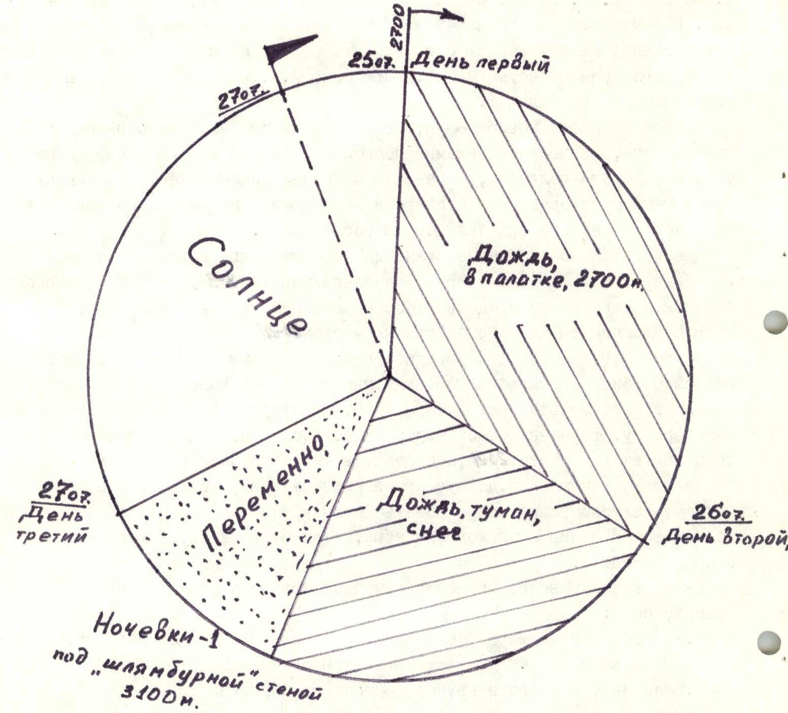
Ascent graph
Team's Tactical Actions
In accordance with the tactical plan, the team started the route on July 25, 1984, at 4:00 from the bivouac on the moraine under the route. At that time, it was drizzling. When the team was in the lower part of the route (photo 1.2), having passed about three rope lengths, a downpour started. Along with the water streams from the "roof," numerous stones and pieces of ice began to fall. The team was at that moment in the middle of the rockfall-prone section R5–R6 (photo 1.4). Three out of four people received minor bruises from the impact of stone and ice fragments.
The only correct decision was made in this dangerous situation:
- — to descend with precautions;
- — to use sections with cornices to protect against falling stones.
The team returned to the bivouac at 8:35. The rain on that day continued until 16:00 with almost no break. It is worth noting that bad weather was across the entire Caucasus that day.
The next day, July 26, it rained again in the morning, and it was only after it stopped that the team managed to start the route at 10:00, instead of the planned 4 hours. The ascent proceeded according to the tactical plan, with a 6-hour time shift, despite the poor condition of the route due to the bad weather.
On that day, the team worked in the following order:
- — 1st rope: Chuenko S.A. — Nedelkin V.I.
- — 2nd rope: Fursov Yu.S. — Plyasov A.G.
The first five rope lengths (section R0–R8, photo #2) were led by Nedelkin V.I. The leader's belay was done on a double rope using a tape absorber, and the ropes were paid out through a Schirttau device. The second and fourth team members moved along the fixed ropes on jugs with top belay, and the third — on double fixed ropes with jugs on a self-belay with prusik knots and bottom belay. The team took five ropes. The time spent on traversing the route to the waterfall (section R0–R8, photo #2) was about three hours.
From the waterfall to the overnight stay near the second control point (section R8–R20, photo), Chuenko S.A. went first. It took about 7 hours to complete this section. Throughout the movement on the route on July 26, it was drizzling, turning into snow with limited visibility in the fog.
To ensure safety:
- — belay positions were chosen under overhangs;
- — constant voice communication was maintained between team members.
Around 20:00, the group set up a bivouac.
At that time, the duo Fursov Yu.S. — Plyasov A.G. worked on processing the wall section of the route, drilled with bolt pitons (section R20–R21, photo 1.4).
The decision to process this section, despite the late hour, was made because:
- — the wall was wet;
- — nighttime frost could form ice;
- — it would complicate the passage the next day.
In one hour of work, 60 m of the wall were processed. A feature of this section is that it was climbed using artificial anchors, utilizing previously hammered-in bolt pitons. Since the distance between the bolt pitons is large (1.5–2 m), it was necessary:
- — to hammer in own pitons for artificial anchors;
- — to use a "hook" to maintain balance while clipping into the piton's eye.
The next day, July 27, 1984, the team started the route at 7:00. As a result of nighttime frost, the rocks were covered with a layer of ice, which:
- — complicated the passage on the processed wall;
- — justified the correctness of the decision to process the wall in the evening.
On that day, the participants were arranged in the following order:
- — Fursov Yu.S. first;
- — Plyasov A.G. second;
- — Chuenko S.A. third;
- — Nedelkin V.I. fourth.
At 12:30, the team passed the wall (section R20–R22) and reached the "roof" (photo 1.4). Here, there was a change of leader according to the tactical plan. Further on the route, Plyasov A.G. led (section R22–R26, photo 1.4) to the summit. The team reached the summit at 17:15 on July 27, 1984.
The descent from the summit was done via the 2A category difficulty route. The group returned to the bivouac in full at 20:15, spending 3 hours on the descent.
On the second day of the ascent, the weather conditions were satisfactory:
- — variable cloudiness;
- — no precipitation.
Throughout the entire route, the team took safety measures as noted in the tactical plan and planned during the preparation for the ascent (see tactical plan and section "Preparation for Ascent").
During the ascent, the team's radio communication with the observation group was stable and followed the radio communication schedule.
Route diagram in UIAA symbols

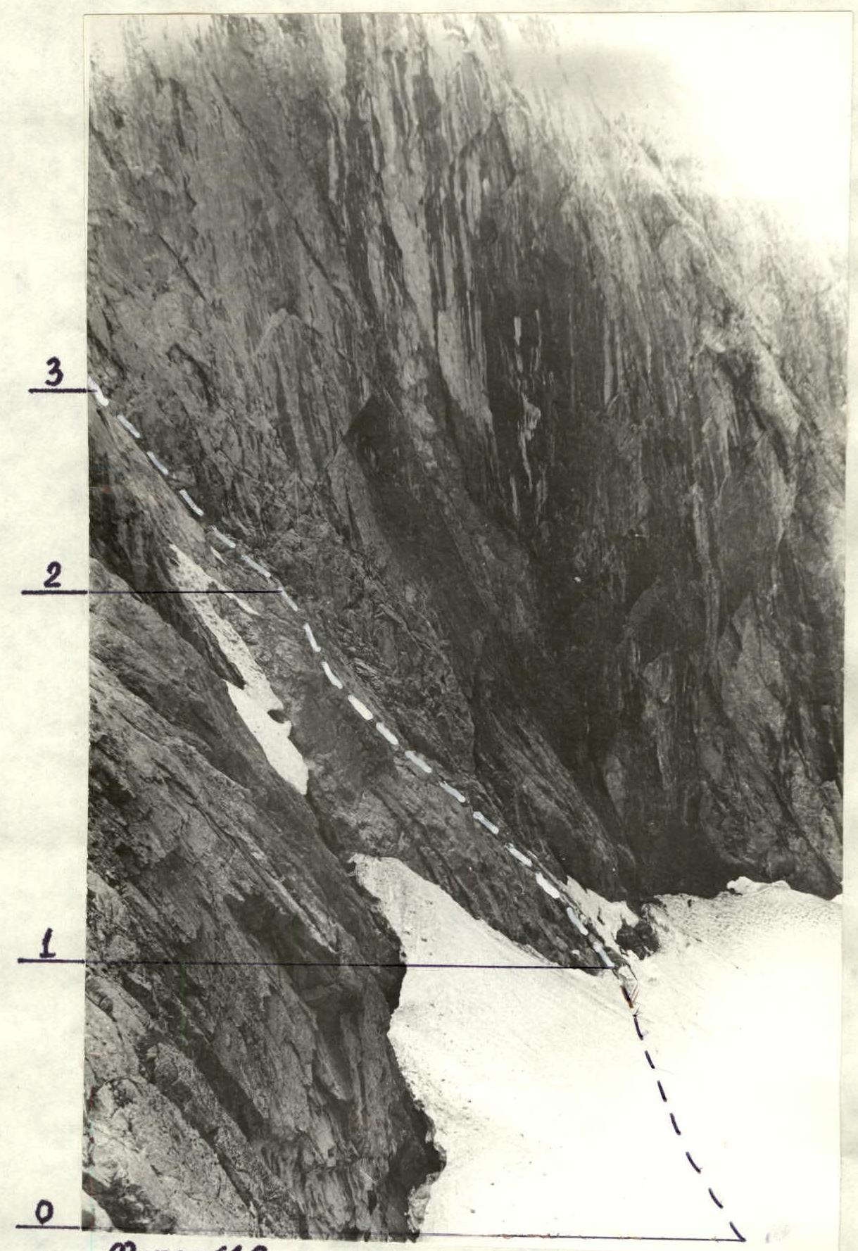
Lower part of the route (profile on the left), section R0–R3.
- Date: July 28, 1984
- Time: 16:00
- Camera: Smena
- Parameters: f=40, S=300 m, H=2800 m
- Lens T-43
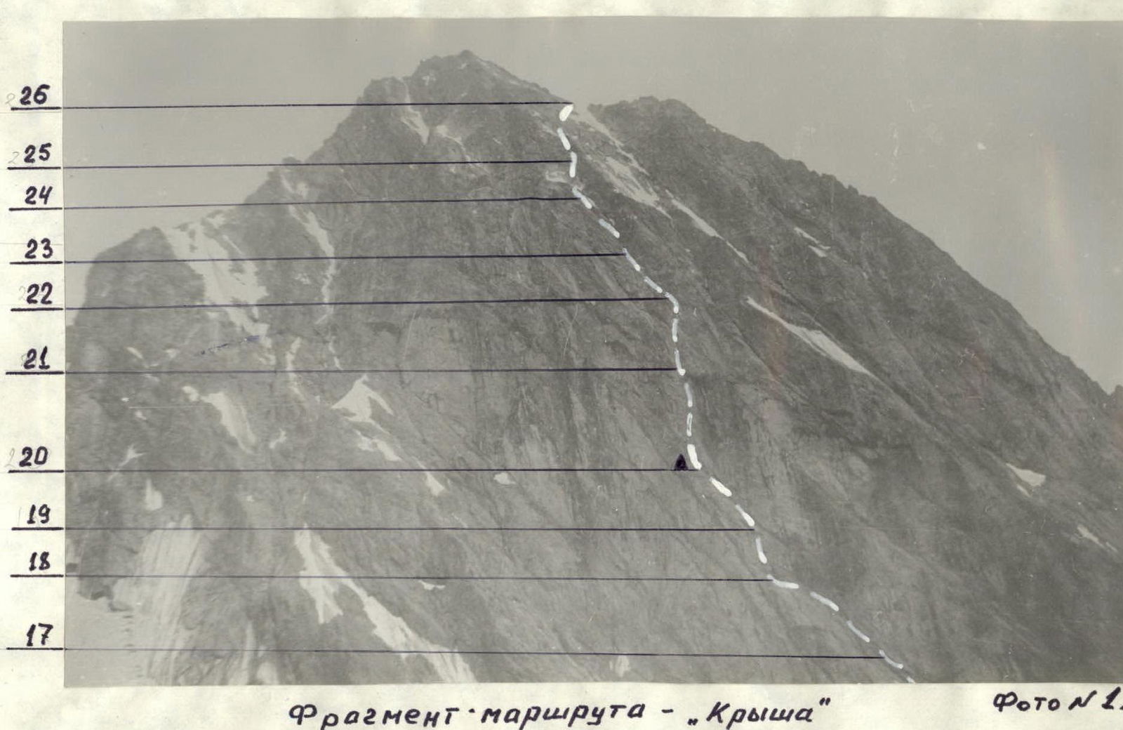
Photo #1.4. Fragment of the route — "Roof". Date: July 28, 1984, 17:00, Smena, F=40, lens T-43, S=2500 m, H=3000 m.


