North-West and Central Federal Districts Alpine Championship, High-Altitude Technical Class 2024. Report on the Ascent to Mt. Dalar via the East Ridge (Kavunenko Route, 1964) 5A Category of Complexity.
I. Ascent Passport
| 1. General Information | ||
|---|---|---|
| 1.1 | Full Name, Sports Rank of the Leader | Strizhko Yulia Gennadyevna, 2nd sports rank. |
| 1.2 | Full Name, Sports Rank of Participants | Radkova Maria Alekseyevna, 2nd sports rank. Rodyukov Oleg Yuryevich, 2nd sports rank. |
| 1.3 | Full Name of Coach | — |
| 1.4 | Organization | VROO "Sports Alpine Federation" |
| 2. Characteristics of the Ascent Object | ||
| 2.1 | Region | Western Caucasus |
| 2.2 | Valley | Kichkinekol |
| 2.3 | Section Number according to the 2013 Classification Table | 2.3.20 |
| 2.4 | Name and Height of the Summit | Dalar, 3988 m |
| 2.5 | Geographical Coordinates of the Summit (Latitude/Longitude), GPS Coordinates | 43°13′20″ N 42°09′42″ E |
| 3. Route Characteristics | ||
| 3.1 | Relief Nature of the Route | Combined |
| 3.2 | Category of Complexity | 5A |
| 3.3 | Name, Year of First Ascent | Via the East Ridge, 1964 (Kavunenko) |
| 3.2 | Altitude Difference of the Route (Altimeter or GPS Data, m) | 1575 m, including ascent – 1327 m, descent – 248 m |
| 3.3 | Route Length (in m) | 2590 m |
| 3.4 | Descent from the Summit | Via rappels |
| 3.5 | Additional Route Characteristics | Water is available near the snow knife. Obtained by melting snow. |
| 4. Characteristics of Team Actions | ||
| 4.1 | Time on the Route (Team's Moving Hours), Time to the Summit, Total Time including Descent, Time from Camp to Camp | 26 h 15 min, 42 h 15 min. |
| 4.2 | Overnights | Two overnight stays on the snow knife |
| 4.3 | Time at Control Points | Departure from the bivouac in the "Green Pocket" — 3:00 (July 25, 2024) Began ascent to the Dvoynyashka Pass — 6:30 On the pass — 11:15 Reached the snow knife. Set up for overnight stay — 20:00 Started ascent — 5:00 (July 26, 2024) Crux of the route — 9:30 Reached the summit — 14:45 Descended to the snow knife to the tent — 19:00 |
| Started rappelling — 5:20 Finished rappelling — 16:00 Returned to camp — 19:30 | ||
| :--: | :--: | :--: |
| 5. Weather Conditions | ||
| 5 | July 25, 2024 — clear, from 16:00 — variable cloudiness. July 26, 2024 — clear, from 9:00 — strong wind gusts, from 17:00 — rain. July 27, 2024 — light rain throughout the day. | |
| 6. Person Responsible for the Report | ||
| 6.1 | Full Name, e-mail | Rodyukov Oleg Yuryevich oleg-rodyukov@yandex.ru +7 910 343-69-97 |
II. Ascent Description
1. Ascent Object Characteristics
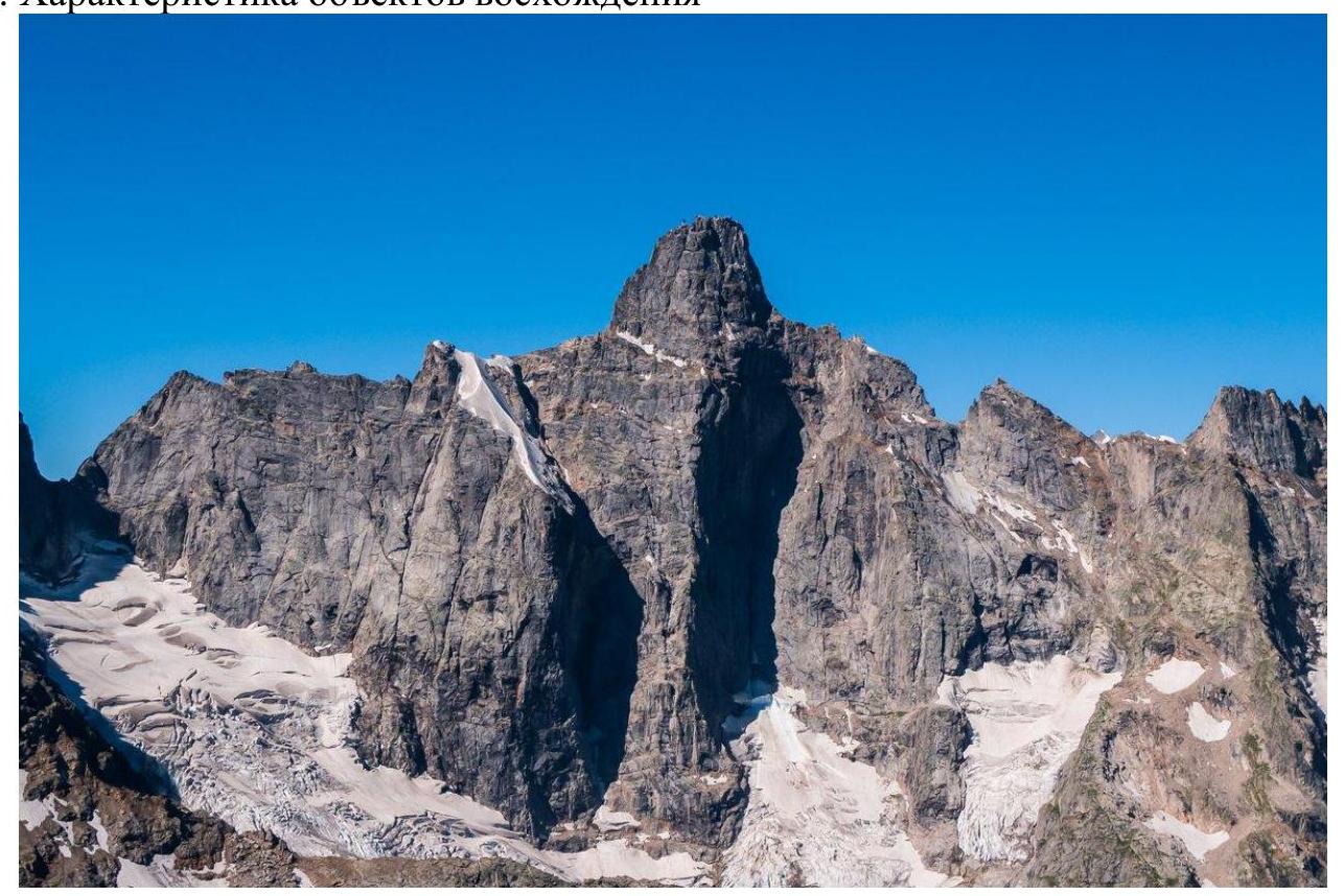
Photo 1 – General photo of the route
1.2 Elevation Profile
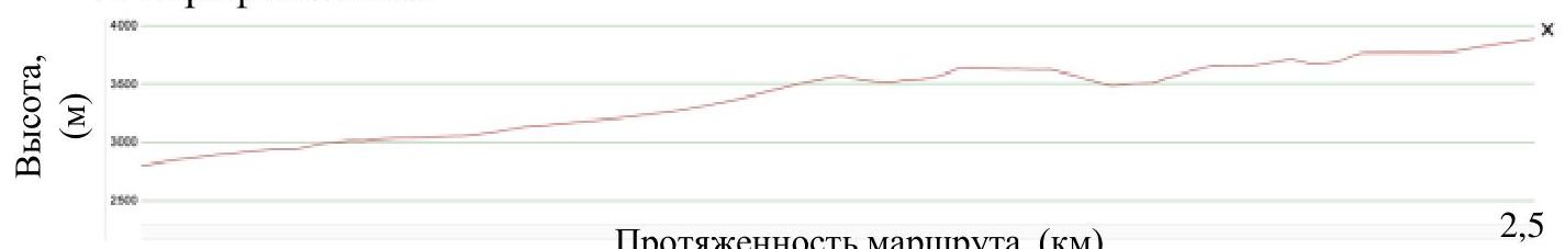
Route length (km)
1.3 Satellite Image
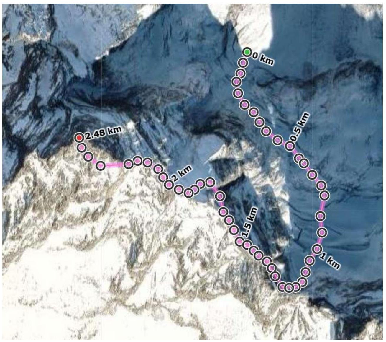
Photo 2. Satellite image with the route
1.4 Area Map
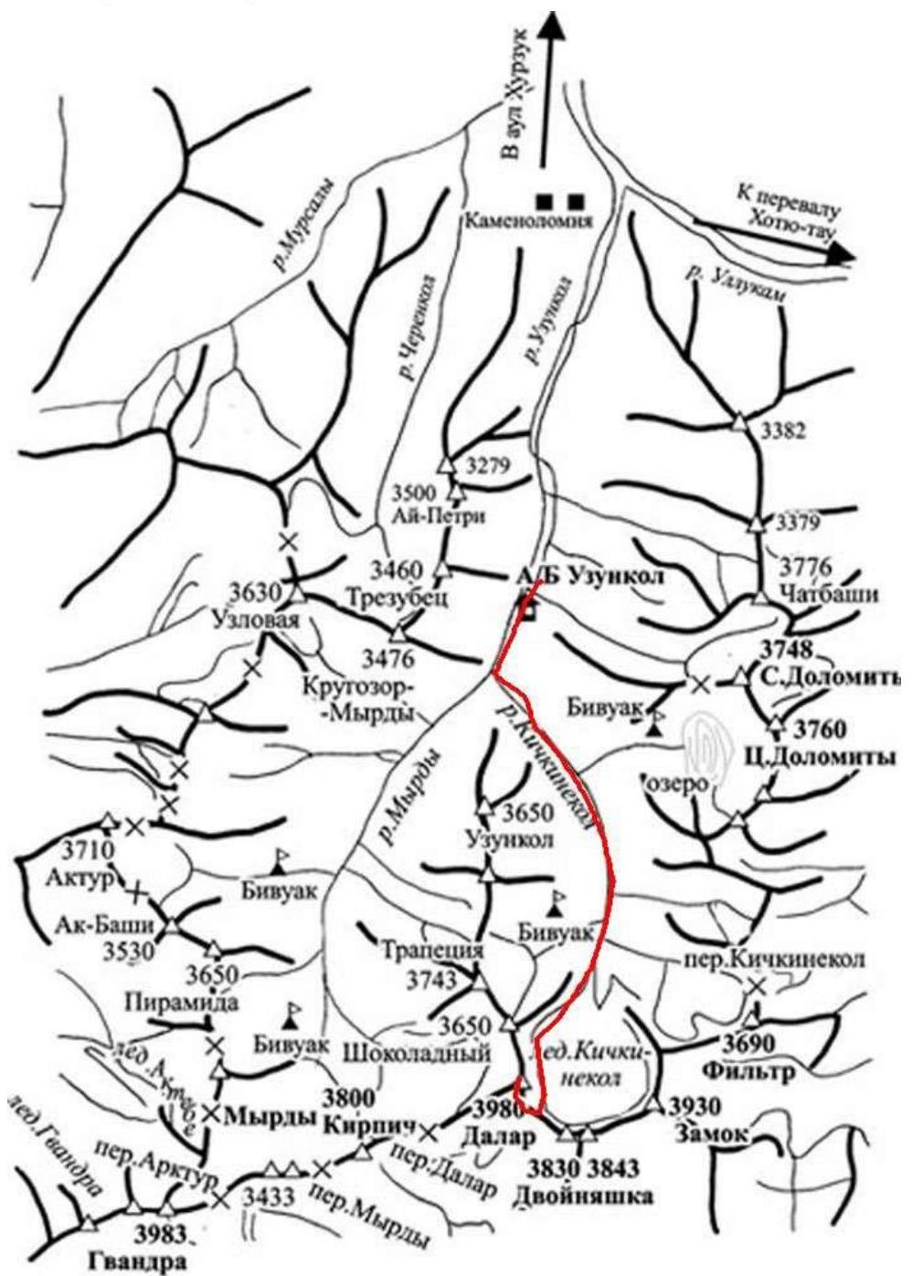
Photo 3. Area map
2. Route Characteristics
2.1 Technical Photo of the Route

Photo 4. Technical photo of the route
- R0–R1: 1100 m, ice, 10–45°
- R1–R2: 35 m, 3, 40–60°
- R2–R3: 100 m, 2–3, 25–55°
- R3–R4: 50 m, 3–4, 45–70°
- R4–R5: rappel 10 m
- R5–R6: 50 m, 3, 35–60°
- R6–R7: 390 m, 1–2+, 10–45°, 3, 10 m, 60°
- R7–R8: 120 m, snow-ice, 30–45°
- R8–R9: 500 m, 1–2, 0–30°, rappel 5 m
- R9–R10: 230 m, 3–6, 40–80°, including 60 m 6, 80°
3. Route Characteristics
| Section # | Description |
|---|---|
| 0–1 | Movement on the closed glacier in a team. Started in the dark on a relatively gentle slope. Then turned left and continued on the glacier. Chose optimal paths among the heavily broken slope and moved left to a flattening, then right and up to the bergschrund under the Dvoynyashka Pass wall. The glacier is heavily destroyed, no obvious bridges. Passed the berg under the rock wall further right, then traversed left on the rock. Did not reach the chain station, set up our own on the monolithic wall and began ascending. Simultaneous movement in a team. |
| 1–2 | Climbing to the pass was done on destroyed terrain. Layers of rocks mixed with sand. The inner corner is wet. The leader moved in crampons. The terrain does not hold against pull-out!!! Insurance was mostly with anchors. The first station was set up on an inclined shelf. Previously, cracks were cleaned (sand and dirt removed). Ultimately, 2 friends and 1 anchor were placed. Alternating movement. |
| 2–3 | The next station was set up on two bolts (a third bolt is nearby but the anchor is half out). The station is inconvenient but protects participants from rockfall. About 50 meters have no reliable insurance points. Moved alternately. Exited onto the pass. |
| 3–4 | Moved alternately due to heavy backpacks. Climbing is not difficult, terrain is rich. |
| 4–5 | 10 m rappel to the saddle. |
| 5–6 | Alternating movement on a positive wall with rich terrain, easy climbing for the leader. Other participants with heavy backpacks found it more challenging. |
| 6–7 | Easy section — mainly on the ridge or along it on the left. Some narrow ledges along the wall, one 10 m inner corner. Moved alternately. Ended at a yellow gendarme. Some descriptions suggest bypassing it on the lower narrow ledge. We went via the upper ledge. Had to rappel down 10 m (from an anchor left by a previous team). Then on a narrow ledge, bypassing the gendarme, we reached the snow knife. Set up a tent on the snow knife after working on the snow slope. Below, towards the rappels, there's a small area for a 1–2 person tent but it's right on the edge. |
| 7–8 | From the tent, ascended a frozen snow slope to the ridge and moved up along the ridge. Then turned right and reached a gap. |
| 8–9 | 5 m rappel, then a dangerous traverse on the right wall of the saddle, destroyed rocks, followed a previously placed rope. Then an easy rock section: simultaneously reached the Dalar tower on a simple ridge and moved left on a wide ledge. |
| 9–10 | Initially moved simultaneously in a team, then alternately, on 3–4 category rocks, to the crux. Climbing at the crux is difficult with some IT. We climbed the wall on the right at the bottom and on the left at the top. After the crux, continued on the ridge. Reached the descent couloir going left. Near the couloir, at 3–4 m height, two bolted anchors. First descent station. Needed to move forward and ascend to the summit ridge. The summit was not obvious, had to search for a cairn. Found three notes in different locations. |
The route is one of the accessible combined routes of 5A category in this area. Main risks during the ascent may arise when climbing to the Dvoynyashka Pass due to the destroyed terrain and increased rockfall danger. The rest of the route is generally monolithic on climbing sections.
Communication with the camp was not always possible via radio. There are options for relaying through alpine groups in the Dolomites area. There was cell phone signal on the snow knife. Also, it's possible to receive transmissions from the Ullu-Tau alpine camp.
The descent from the summit tower was done via the descent couloir, using bolted stations over about 3–4 ropes. Then moved left on a wide ledge. This led to the start of the tower. Returned to the snow knife. The rappel line starts at the bottom of the snow knife. On a large rock, two bolted anchors, from which the descent towards the Uzunkol alpine camp began. There are two bolted paths on the descent line. The path with green marking indicates further descent with green arrows. Rope lengths on this path are from 30 to 50 meters. 17 rappels in total, exiting onto the glacier. The final rappel is very close to the waterfall. In our case, exiting onto the glacier was complicated by a deep and wide randkluft, which we crossed on a sling. Moved on the glacier in a team, avoiding crevasses, and tried to quickly pass areas with obvious rockfall. At the end of the glacier, where it flattens, removed crampons and stowed the team rope.
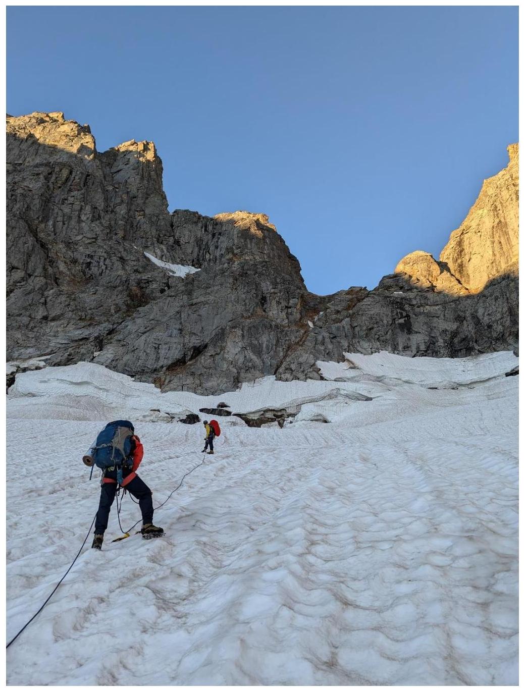
Photo 5. End of the glacier on section R0–R1. View of the Dvoynyashki Pass ("Pereval Dvoynyashka").
The translation is now complete.


