North-West and Central Federal Districts Alpine Championship. Technical Altitude Class. 2024
Report on the Ascent of Dalar Peak (3988 m) via the Eastern Ridge (V. Kavunenko Route, 1964), Category 5A, Combined Terrain
The route was completed by the team from the Alpine Club of St. Petersburg, under the auspices of the "OGK" (St. Petersburg). Team Captain: A.V. Kichurchak.
Ascent Passport
| 1. General Information | ||
|---|---|---|
| 1.1 | Full Name, Sports Rank of the Leader | Andrey Vladimirovich Kichurchak, 1st sports rank |
| 1.2 | Full Name, Sports Rank of Participants | Elena Vadimovna Aleksandrova, 1st sports rank |
| 1.3 | Full Name of Coach, Sports Rank | D.M. Kiselev, Candidate Master of Sports |
| 1.4 | Organization | St. Petersburg Alpine Federation, "OGK" Alpine Club |
| 2. Characteristics of the Ascent Object | ||
| 2.1 | Region | Western Caucasus, Kichkinokol Valley |
| 2.2 | Section Number according to the Russian Electronic Classifier of Mountain Routes / Route Number | From Nakhar Pass to Chiperazau Pass / 20 |
| 2.3 | Name and Height of the Peak | Dalar, 3988 m |
| 2.4 | Geographical Coordinates of the Peak | 43°13′27″ N, 42°9′53″ E (43.224060, 42.16467) |
| 3. Route Characteristics | ||
| 3.1 | Route Name | via the Eastern Ridge (V. Kavunenko, 1964) |
| 3.2 | Complexity Category | 5A |
| 3.3 | Terrain Type of the Route | Combined |
| 3.4 | Height Difference of the Route | 1388 m (from the "green pocket" to the summit) |
| 3.5 | Route Length | 3800 m (1900 m along the glacier to the saddle, 1800 m along the ridge) |
| 3.6 | Technical Elements of the Route | Snow – 10–30° — 1800 m Snow – 40–60° — 150 m Climbing – 910 m, 3 – 530 m, 4 – 420 m, 5+ – 25 m Rappel – 10 m, 40 m, 15 m |
| 3.7 | Average Slope of the Entire Route | 50° |
| 3.8 | Descent from the Summit | From the summit, 5 rappels of 30–55 m down the SW couloir of Dalar's tower, followed by simultaneous descent to the snow "knife," then 18 rappels of 40–55 m along pre-drilled stations |
| 4. Characteristics of the Team's Actions | ||
| 4.1 | Travel Time (team's travel hours, indicated in hours and days) | 17.5 hours, 3 days |
| 4.2 | Overnights | Three lying-down overnights: 1st – July 19, on the ridge, first third of R5–R6; 2nd and 3rd – July 20, 21, under the summit tower near R11 |
| 4.3 | Route Processing Time | No processing |
| 4.4 | Start of the Route | July 19, 2024, 04:00 |
| 4.5 | Summit Ascent | July 21, 2024, 09:30 |
| 4.6 | Return to the "green pocket" | July 22, 2024, 17:00 |
| 4.7 | Return to the "Uzunkol" tourist center | July 22, 2024, 19:00 |
| 5. Weather Conditions Characteristics | ||
| 5.1 | Temperature | +1°C – +10°C |
| 5.2 | Wind Force | July 19 – calm until 16:00, then gusty storm; July 20 – gusty storm until 14:00, then up to 10 m/s; July 21 – 1–4 m/s, gusty; July 22 – 1–4 m/s |
| 5.3 | Precipitation | July 19 – no precipitation until 16:00, then sudden deterioration: stormy wind, blizzard, wet snow. July 20 – stormy wind, wet snow until 14:00, then unstable cloudy weather, occasional wet snow, then drizzle until the end of the day. July 21 – unstable weather until 07:00, drizzle, then improvement. Afternoon – good weather, sun, partly cloudy. July 22 – good weather, partly cloudy. |
| 5.4 | Visibility | July 19 – clear, good visibility until 16:00, then no visibility, storm, blizzard. July 20 – heavy cloud cover all day, fog. July 21 – cloudy until 12:00, then partly cloudy, good visibility. July 22 – partly cloudy, good visibility. |
| 6. Report Responsible | ||
| 6.1 | Full Name, e-mail | Elena Aleksandrova, alpinizm78@mail.ru |
Description of the Ascent Area
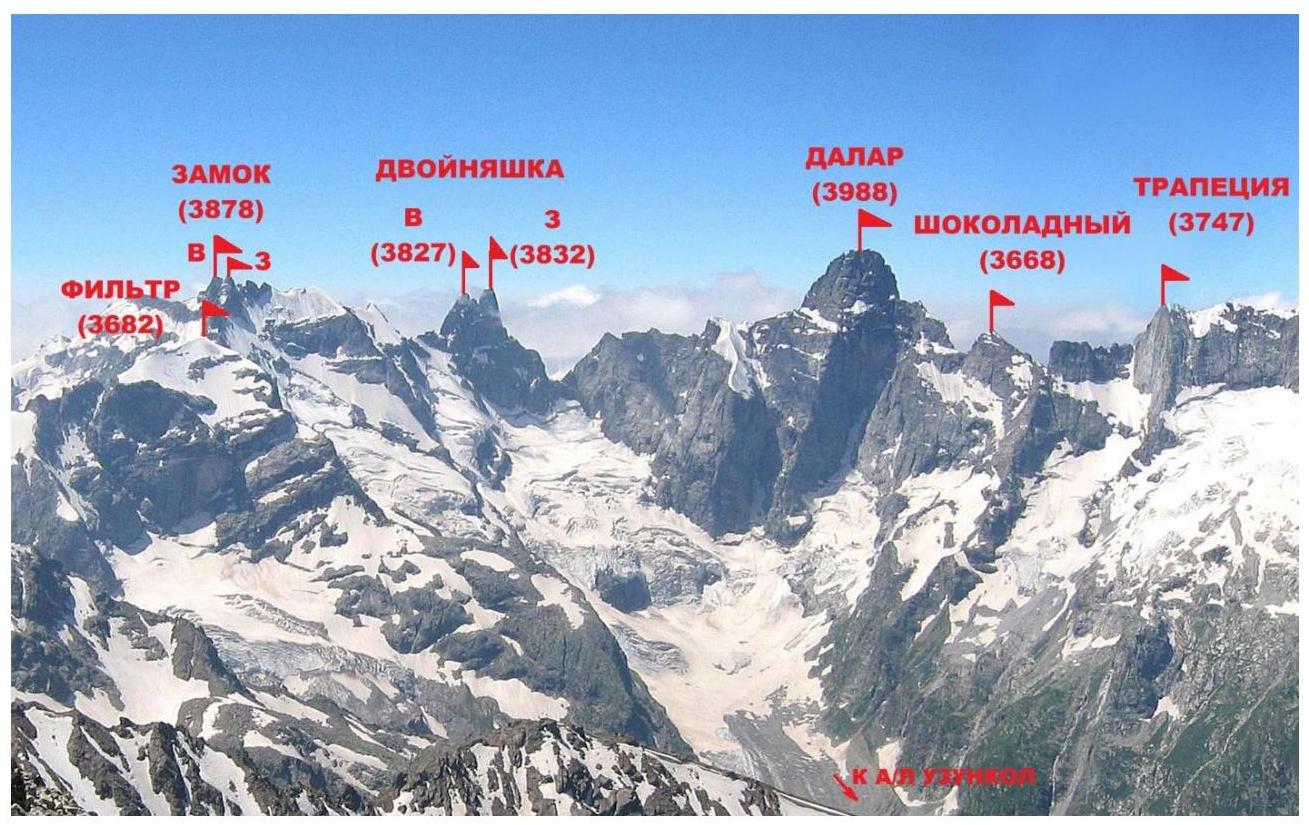
Dalar (3988 m) is one of the most beautiful peaks in the Caucasus. It is located in the Gvandra region of the Western Caucasus within the Central Uplift of the Main Caucasian Range, 25 km southwest of Elbrus. The peaks of this region are primarily composed of strong granito-gneiss rocks with minimal cracking and smoothed micro-relief. The main peaks of the Gvandra region, such as Kirpich (3751 m), Dalar (3988 m), Dvoynashka (3832 m), Zamok (3878 m), and Trapezia (3747 m), generally do not have easy routes; their walls are among the most challenging in the Caucasus.
The chain of peaks Filter – Zamok – Dvoynashka – Dalar – Shokoladny Peak, located in the upper reaches of the Kichkinokol Valley, bounds the Bolshoy Kichkinokol glacier cirque from the east, west, and south, giving rise to the eponymous river that flows into the Uzunkol River.
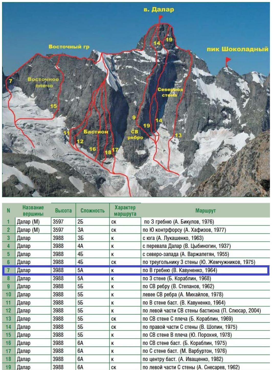
The first ascent of Dalar was made in 1937 by a group led by Kizel and Budanov via a route categorized as 4A from the Dalar Pass. According to the Russian electronic classifier of mountain routes, there are currently 21 alpine routes to the Dalar summit, including:
- Five routes categorized as 6A;
- Eight routes categorized as 5B;
- Four routes categorized as 5A.
Routes to Dalar are classic examples of technically complex mountaineering and have repeatedly won prizes in championships.
To date, the sporting potential of the peak is far from exhausted. Due to the extensive length of its northern, northeastern, and eastern walls, Dalar continues to attract mountaineers.
Panorama of the ascent area
Approach to the Campsite
From the Uzunkol tourist center, move towards the Dolomite campsite. Before reaching the turn that begins the steep ascent to the Dolomite campsite, cross to the left (orographically) bank of the Kichkinokol River and follow the path along the river. The path leads to the lateral moraine of the glacier and continues along its sharp crest. There are three campsites with tent platforms in the "green pocket." Water is available (waterfall). The journey from the Uzunkol tourist center takes 2–3 hours.
Map-scheme of the area with the approach to the campsite in the "green pocket"

General photo of the route with nearby routes marked
Technical photo of the route

Route Description by Sections
Approach to the route: From the "green pocket" campsite, descend to the glacier and move towards the northern wall of Dalar. Traverse the glacier southeastward. Reach the central, gently sloping part of the glacier and approach the saddle between Dvoynashka Peak and Dalar Peak. The glacier is open, with crevasses, and potentially rockfall-prone. It is necessary to move in teams, choosing the safest path between crevasses. The overall slope of the glacier is 25–30°, but there are sections with a slope of 40–45°. Snow bridges near the saddle melt quickly, and their location varies each year. The team's approach to the saddle is detailed in the "Route Photos" section. The journey from the campsite to the approach to the keyhole between the glacier and the saddle takes 3 hours. Movement across the glacier is recommended during early hours.
R0–R1 (10 m, 5+, 70°, 30 m, 3, 60°)
From the keyhole, climb onto the rocks of the saddle: challenging climbing in crampons on wet, sandy rocks. Then move upward and right for about 10 m to an inconvenient station on bolts (R0). Continue upward along moderately difficult rocks or traverse along the glacier edge, as the participants did. Further climbing on rocks to a station with bolts and a chain in an internal corner. Removed crampons. The leader changed into rock shoes. Climbing in boots could be less careful.
R1–R2 (160 m, 2–3+, 50–70°)
Ascend through a destroyed rock couloir towards the top of the saddle. Attention: despite the straightforward terrain, the rocks are heavily destroyed. Alternate movement is recommended due to rockfall risk. On the right (in the direction of travel) wall, there are two intermediate stations on bolts. Movement through the couloir is also recommended during early hours. Stations on bolts along the couloir are set up for descent, so some may seem illogically positioned for ascent. However, they are better protected from rockfall and provide safer belays for the leader.
R2–R3 (80 m, 3, 50°)
From the saddle, move upward along the ridge with varied terrain, sometimes using simultaneous movement with intermediate protection.
R3–R4 (10 m)
Rappel into a dip on the saddle.
R4–R5 (50 m, 4, 60°)
From the saddle, ascend the wall (initially on the right).
R5–R6 (300 m, 2–4)
Mainly a walking section. Some narrow ledges along the wall and an internal corner (10 m). The team's first overnight stay is here. The internal corner can be wet and snowy during bad weather. The team climbed alternately, with the leader wearing crampons. Further ascent along the ridge, alternately, with intermediate protection. Before reaching the snow "knife," bypass a large gendarme with a yellow wall on the right via narrow ledges. A station on bolts is located at the end of the ledges.
R6–R7 (40 m)
From the station on bolts, rappel onto the snow "knife."
R7–R8 (150 m, 2, 50–60°)
Traverse along the snow "knife" towards its tip, then ascend to the ridge. Protection can be set on ice axes. The team traversed this section simultaneously.
R8–R9 (300 m, 1–2)
Move along the ridge on snow and rocks (1–2 category).
R9–R10 (15 m)
Rappel (15 m) from rocks.
R10–R11 (100 m, 2)
Ascend along the ridge on rocks (1–2 category). Reach a gentle part of the ridge with several well-equipped tent platforms. The team's second overnight stay is here.
R11–R12 (200 m, 2)
Approach the Dalar tower along a straightforward ridge and move along a wide, gravelly ledge to its end, reaching a distinct platform near a former snow- and rock-filled depression.
R12–R13 (100 m, 3, 40°)
Traverse the depression at an angle of 35–40° and approach the upper continuation of the southern counterfort of the peak – a rocky rib leading to the summit tower and bounding the depression on the left.
R13–R16 (120 m, 4-, 60°)
Ascend the counterfort to the ridge, reaching a characteristic dip, then upward under the 70-meter gendarme (R16). Avoid entering narrow couloirs due to rockfall risk. A control cairn is located on the gendarme's summit.
R16–R20 (65 m, 4, 70°, 15 m, 5+, 70°)
Continue via stepped rocks to a ledge under the second gendarme (R20).
R20–R23 (45 m, 4, 60°)
A series of walls and ledges lead to the summit of the second gendarme (R23).
R23–R24 (5 m descent, 40 m, 4, 50°)
Descend into a dip (5 m), then ascend to the ridge.
R24–R25 (120 m, 3+)
Ascend along a 120-meter rocky ridge to the Dalar summit.
Descent:
From the summit, descend to the southern side of the summit tower, then follow pre-drilled rappel stations from the base of the snow "knife." Initially, descend slightly along the ridge to a cairn, then follow five pre-drilled rappels. After the first rappel (20 m), there is a good horizontal platform protected by overhanging rocks, suitable for camping. Opposite the platform, the bolts for the second rappel are visible. After the rappels, descend one rope length to the base of the summit tower onto a ledge running along the tower. Traverse along this ledge (200 m) to the shoulder of the Eastern Ridge. Continue down simple rocks towards the snowy-ice ridge. Overcome a 10–15 m dip (the team used a rappel). Reach the top of the snow "knife," where a rappel loop and a station on bolts are located. Two rappels (60 m and 40 m) lead to rocks. At the end of the rocky ridge, a rappel station is located (bolts marked with green paint). Complete 18 rappels (40–55 m). The final rappel onto the glacier is complicated by a large keyhole. Descend the glacier in teams, avoiding crevasses. The team's descent route follows the glacier down to the moraine and back to the "green pocket" campsite. From there, descend to the Uzunkol tourist center via the trail.
Safety Assessment and Recommendations for Climbers
— Movement through the couloir of the saddle is recommended during early hours due to rockfall risk on the destroyed rocks. — The start of the next rappel should be determined logically, as rappel stations are typically set in safe locations, such as under overhanging rocks or slightly offset from the upper station. In this year's conditions, red repcords were added to the stations to improve visibility. On the diagonal rappel ending at a waterfall, move right along a horizontal ledge without descending further along the waterfall. Then, locate the next rappel station on the right wall.
Route diagram in UIAA symbols

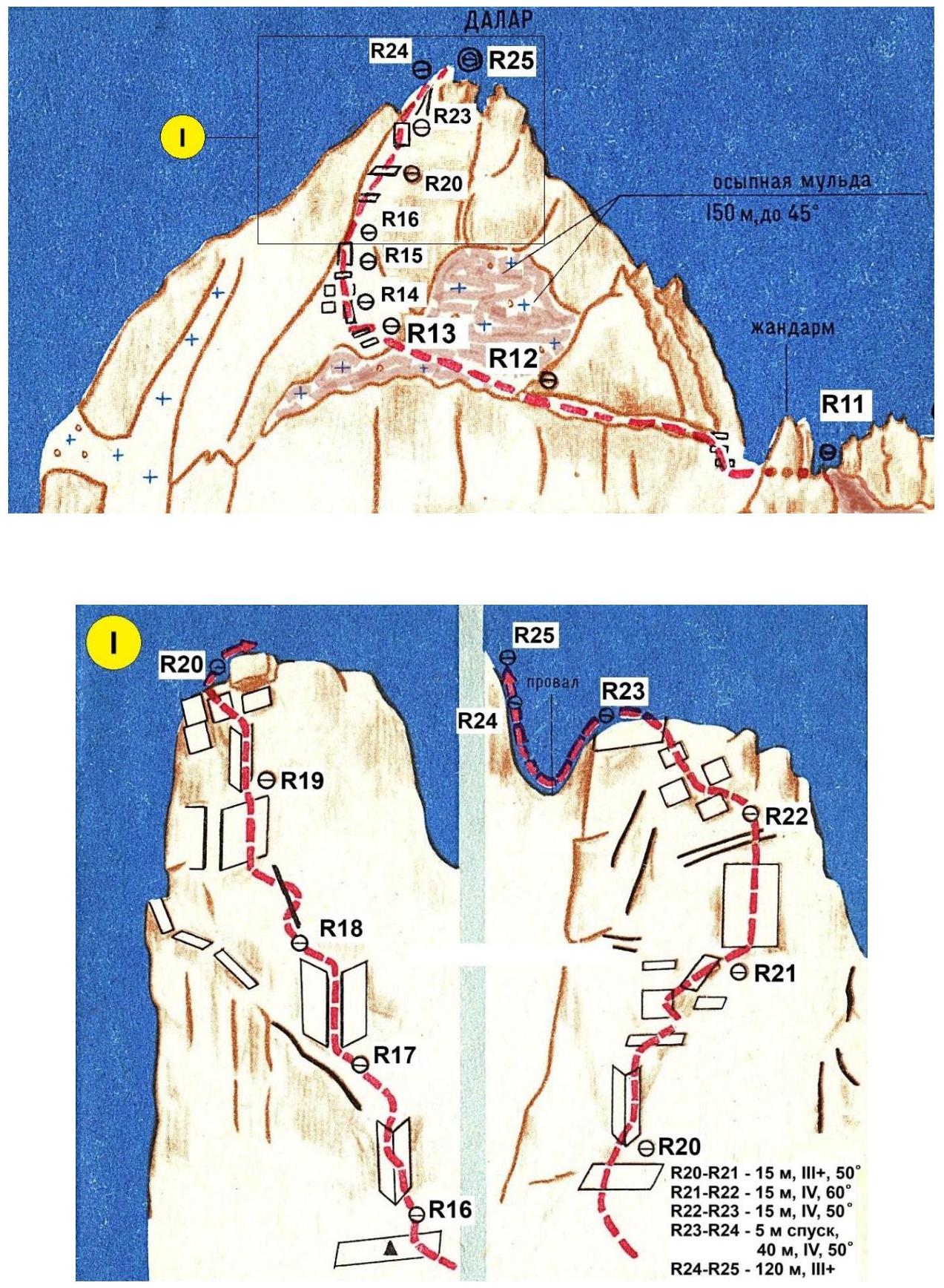
R20–R21 — 15 m, 3+, 50°; R21–R22 — 15 m, 4, 60°; R22–R23 — 15 m, 4, 50°; R23–R24 — 5 m descent; R24–R25 — 120 m, 3+
Ascent Schedule and Weather Conditions
Weather conditions in the ascent area in July were challenging. Unstable weather, frequent thunderstorms, and rain contrary to forecasts, along with anomalously high temperatures in the mountains, led to reduced weather windows and unpredictable shifts. The forecast for July 19–21 indicated a weather window, followed by deterioration. However, the actual deterioration shifted to the days of the team's ascent.
Weather Conditions by Day:
July 19 — clear, no precipitation until 16:00, then sudden deterioration: stormy wind, blizzard, wet snow. July 20 — stormy wind, wet snow until 14:00, then unstable cloudy weather, occasional wet snow, followed by drizzle until the end of the day. July 21 — unstable weather until 07:00, drizzle, then improvement. Afternoon — good weather, sun, partly cloudy. July 22 — good weather, partly cloudy.
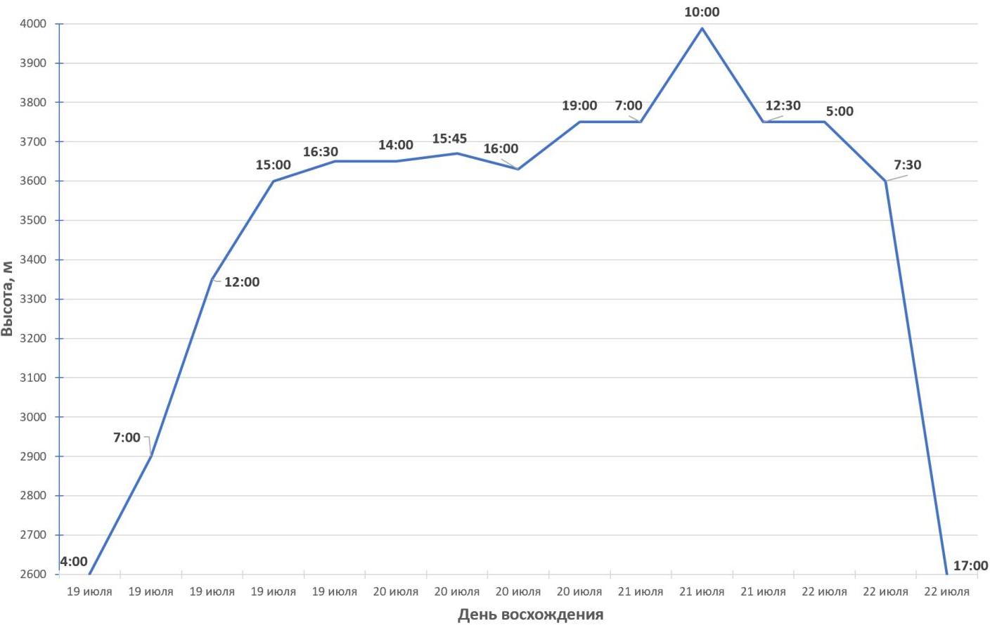
July 18, 2024 (approach, 2 hours)
- Departure from the Uzunkol tourist center to the "green pocket" campsite: 10:00
- Arrival at the "green pocket" campsite: 12:00
July 19, 2024 (9.5 travel hours)
- Departure from the campsite: 04:00
- Start of work on the saddle (R0): 07:00
- Reach the saddle (R4): 12:00
- Reach the ridge: 15:00
- 1st overnight stay on the ridge (platform under the wall, bad weather): 16:30
July 20, 2024 (5 travel hours)
- Weathering bad weather until 14:00
- Start of work on the route: 14:00
- Rappel onto the snow "knife" (R7): 16:00
- 2nd overnight stay under the summit tower (R11): 19:00
July 21, 2024 (3 travel hours)
- Start of work on the route: 07:00
- Summit ascent: 10:00
- Start of descent from the tower: 10:30
- Return to the overnight stay under the tower (3rd overnight stay): 12:30
July 22, 2024 (descent)
- Start of work on the route: 05:00
- Descent to the start of the 18 rappels: 07:30
- Descent onto the glacier: 14:30
- Return to the moraine campsite: 17:00
Team Tactics and Free Description of the Team's Actions
Team Preparation
The "OGK" Alpine Club team prepared for the ascent of Dalar (5A category) by conducting acclimatization hikes in the Uzunkol alpine camp and completing a sporting ascent of Uzunkol Peak (category 2B). One participant, Andrey Kichurchak, had previously completed two ascents (5A and 5B) in the Bezengi alpine camp. The team's rock climbing skills allowed them to navigate challenging sections with free climbing.
Route Completion
The team completed the route without prior processing. Both participants climbed with backpacks. The leader was belayed with two dynamic ropes. The leader completed all sections with free climbing, setting up top-rope belays for the second participant with a heavier backpack. Ridge sections were generally traversed simultaneously with intermediate protection between participants. The rock section of the route is largely monolithic but has some sections with semi-destroyed rocks and live rocks.
Initially, the team planned to complete the route in 3 days, but due to unexpected shifts in the weather window and sudden deterioration, they were forced to camp on July 19 at R5–R6. The team endured a stormy night and the following morning, with strong gusty winds and wet snow accumulating on the tent.
The next day, July 20, they waited out the storm until 14:00. In more tolerable weather, they continued along the ridge. The weather remained unstable, with heavy cloud cover, fog, and occasional snow and rain. They traversed an internal corner, with the leader wearing crampons and the second participant following on a rope. They bypassed a gendarme with a yellow wall on the right via a narrow ledge and reached a station on bolts. From there, they rappelled 40 m onto the snow "knife" and ascended simultaneously with ice axes. They reached suitable campsites under the summit tower by 19:00.
On July 21, they began their ascent at 07:00 in overcast weather. They traversed a wide ledge along the tower and ascended a former depression, climbing along rocks with a stream. They then ascended a counterfort-rib simultaneously with intermediate protection and reached a cairn. Further ascent was done alternately until a 5 m dip. They then reached the ridge and continued to the summit, arriving at 10:00.
They began their descent at 10:30 via pre-drilled rappels on the southern side of the summit tower. By this time, the weather had improved, with sunshine. Some rappel stations were high above, making descent less convenient. After descending to a large gravelly ledge along the tower, they traversed down to their overnight stay via the ascent route. They decided to follow the safety officer's recommendation to start their rappel descent the next morning, as they were unfamiliar with the rappel station locations. Thus, they spent the remaining day at the campsite, drying their gear and resting.
On July 22, they departed at 05:00, reached the top of the "knife" by 06:30, and organized a rappel from a good, monolithic rock outcrop to a station below (R6). They reached the start of the 18 rappels by 07:30 and descended onto the glacier by 14:30. The weather was partly cloudy, and they safely returned to the "green pocket" by 17:00. After a tea break, they descended to the Uzunkol tourist center.
List of Equipment Used
- Main rope — 2 pcs.
- 8 mm repcord — 4 pcs.
- Rock protection (Nuts) — 8 pcs.
- Rock protection (Friends) — 8 pcs.
- Rock protection (Tricams) — 4 pcs.
- Anchor hooks — 8 pcs.
- Rock hammer — 2 pcs.
- Extraction tool (Extraktor) — 2 pcs.
- Quickdraws (60 cm) — 20 pcs.
- Station slings — 4 pcs.
- Non-locking carabiners — 40 pcs.
- Locking carabiners — 10 pcs.
- Jumar — 2 pcs.
- Block-pulley — 1 pc.
- Belay device (ATC type) — 2 pcs.
- Ice axe — 2 pcs.
- Crampons — 2 pcs.
- Backpack — 2 pcs.
- Assault tent — 1 pc.
- Helmet — 2 pcs.
- Headlamp — 2 pcs.
- Sleeping bag — 2 pcs.
- Sleeping mat — 2 pcs.
- Gas stove — 1 pc.
- Gas canisters (230 g) — 2 pcs.
- First aid kit — 1 pc.
- Radio station — 2 pcs.
Route Photos
Photo #1 — Campsite in the "green pocket"
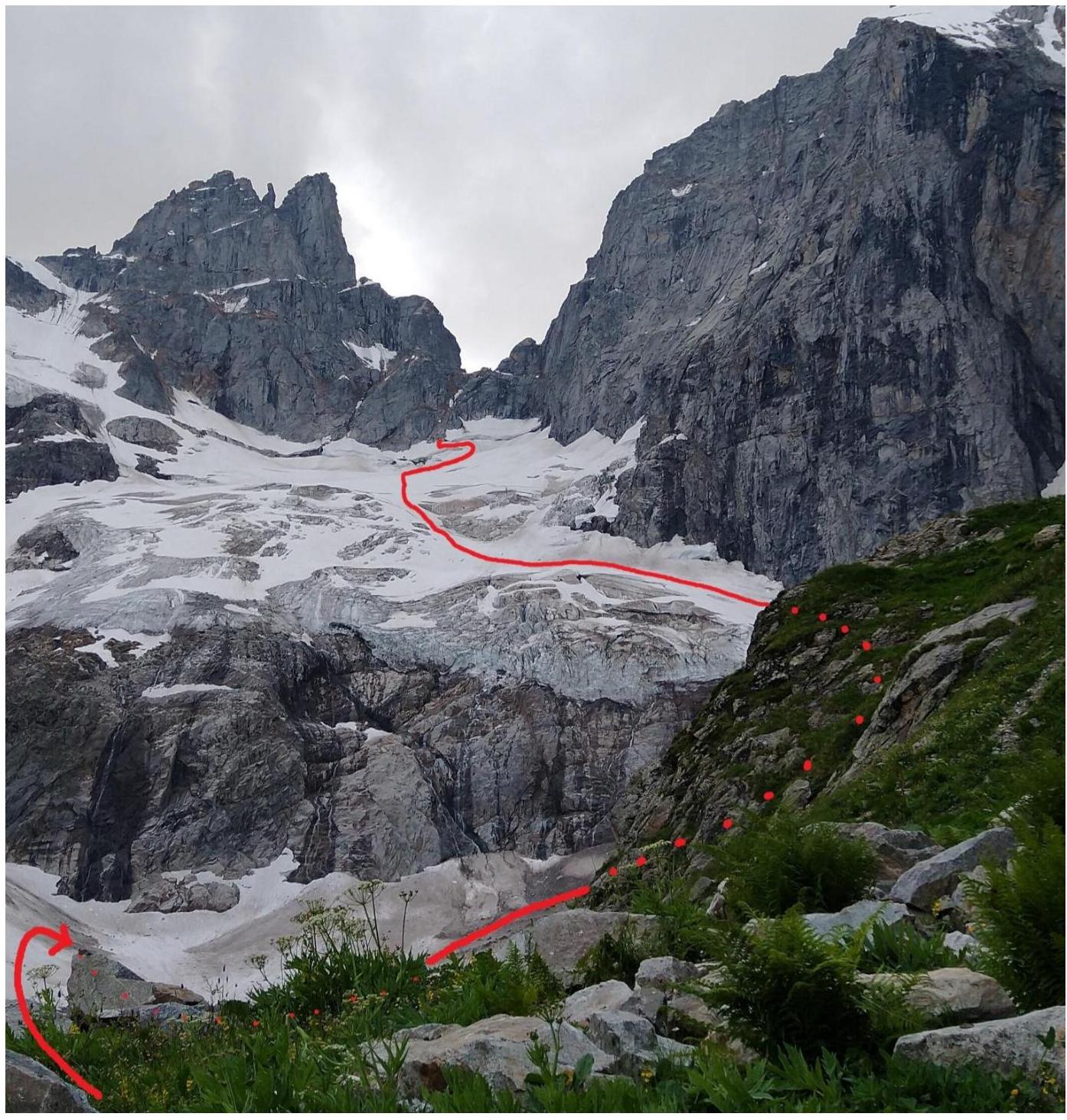
Photo #2 — Approach from the "green pocket" along the glacier to the start of the route
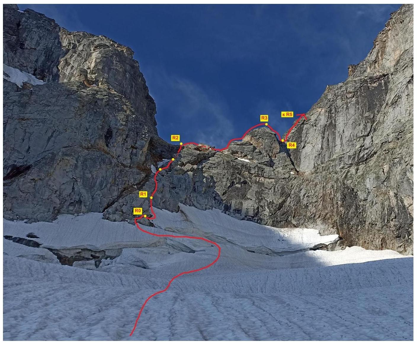
Photo #3 — R0–R2–R4. Start of the route, ascent to the saddle and to the rappel into the dip (R4)
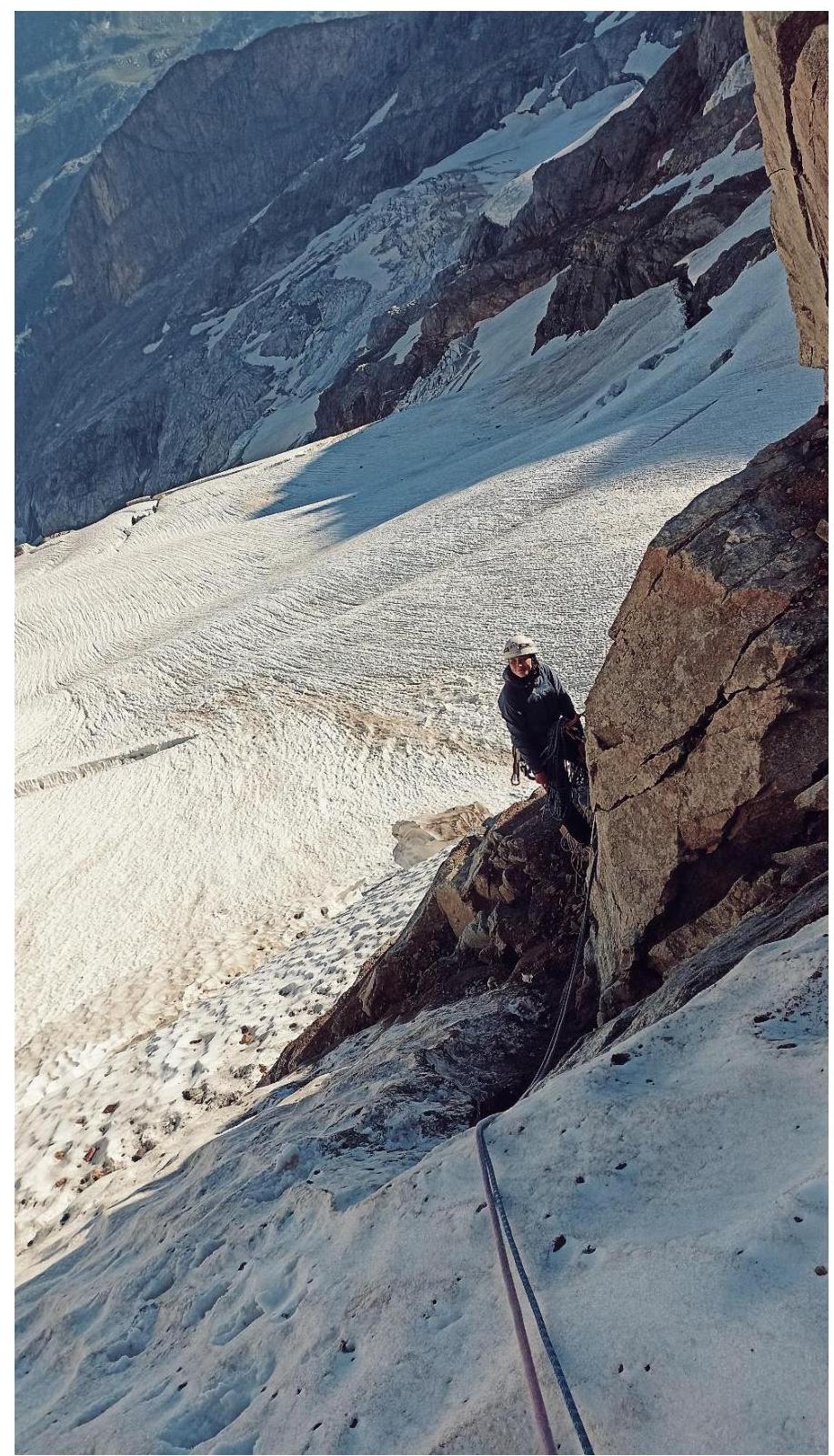
Photo #4 — View of the R0 station
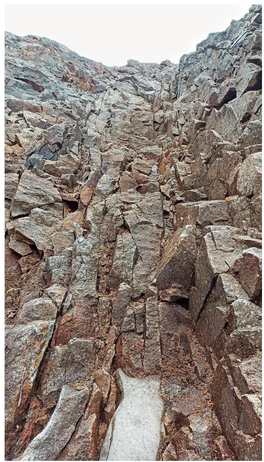
Photo #5 — Destroyed terrain on the ascent to the saddle R0–R2 (extracted rocks are removed by hand)
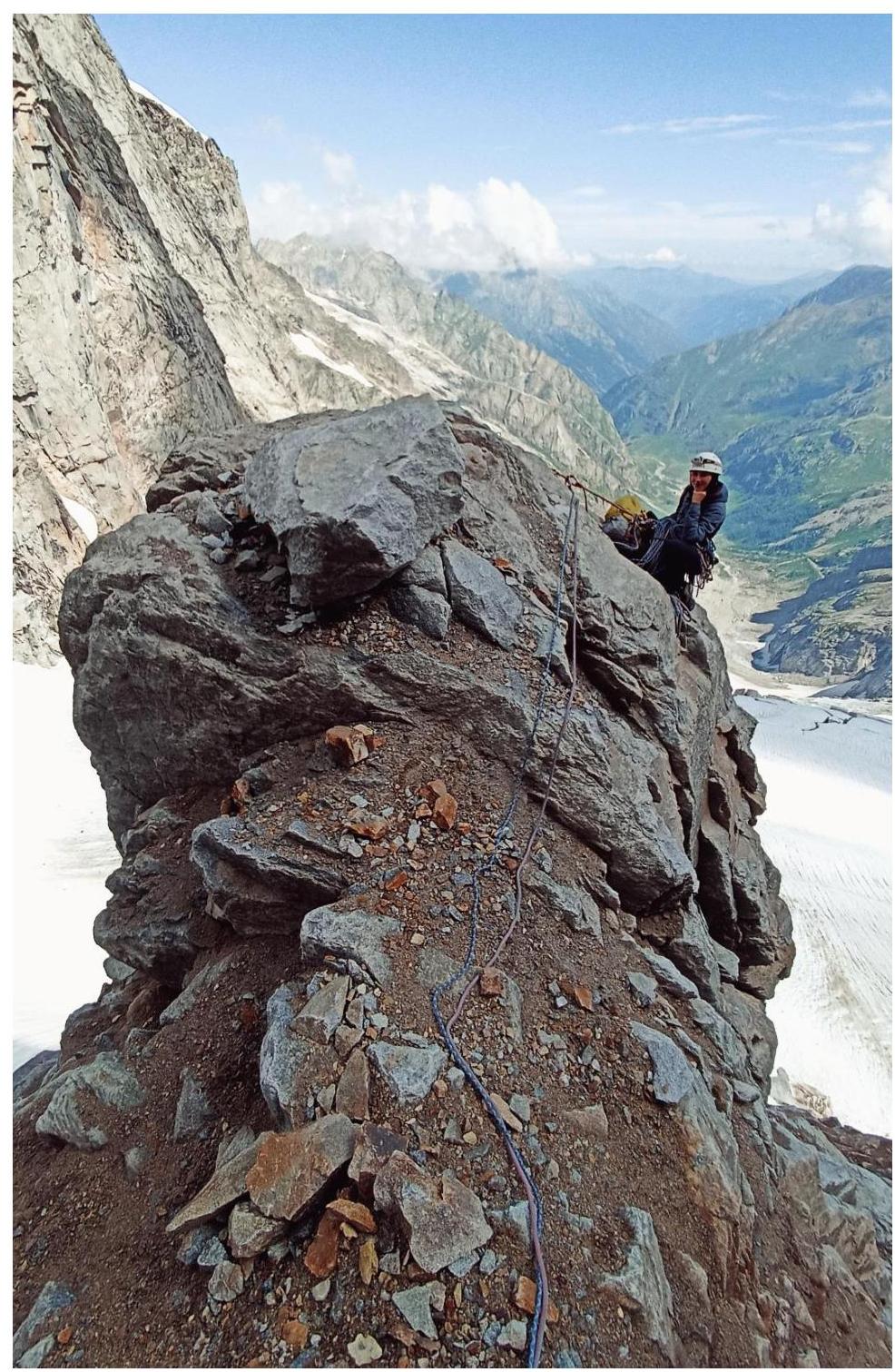
Photo #6 — R1–R2. Ascent to the saddle. Station on bolts on the "bump"
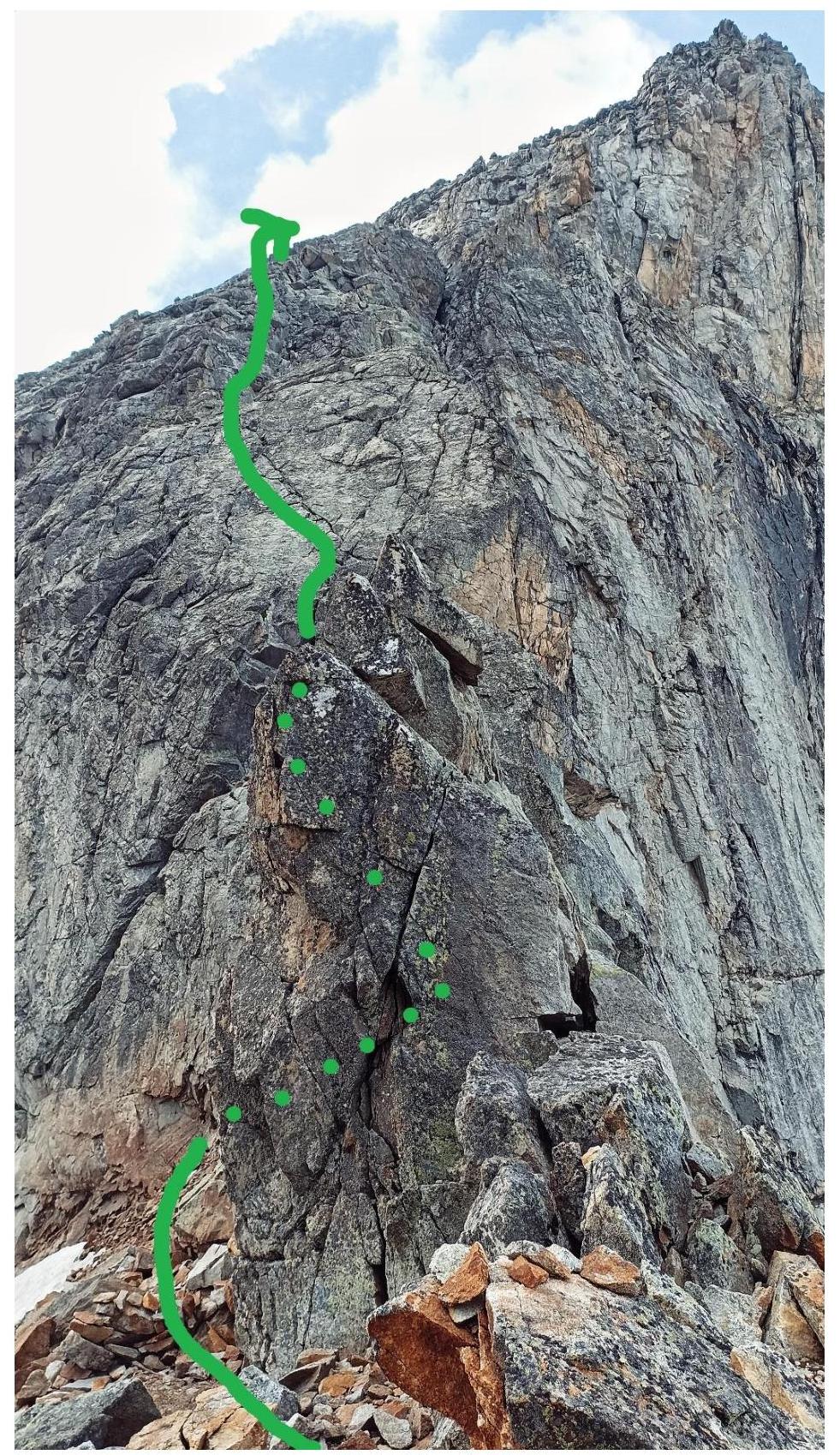
Photo #7 — R2. On the saddle between Dvoynashka and Dalar. Further R2–R3 (pleasant, easy climbing)

Photo #8 — R5–R6. First third of the ridge. Start of bad weather. The platform for the tent is visible ahead
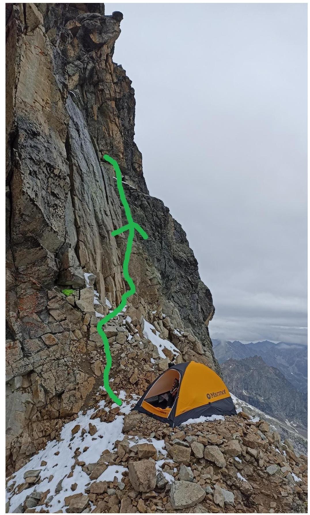
Photo #9 — R5–R6. Overnight stay on the ridge on July 19, 2024

Photo #10 — R5–R6. Morning of July 20, 2024. Waiting out bad weather until 14:00
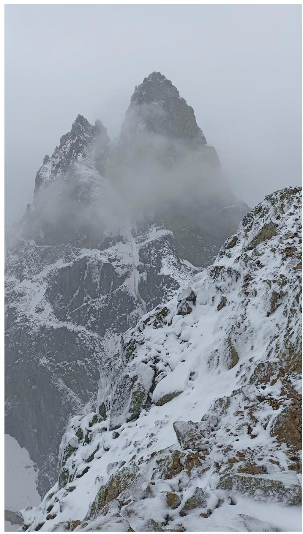
Photo #11 — Exiting the tent onto the route on July 20, 2024, at 14:00

Photo #12 — R5–R6. Gendarme with a yellow wall visible ahead. Weather is more tolerable
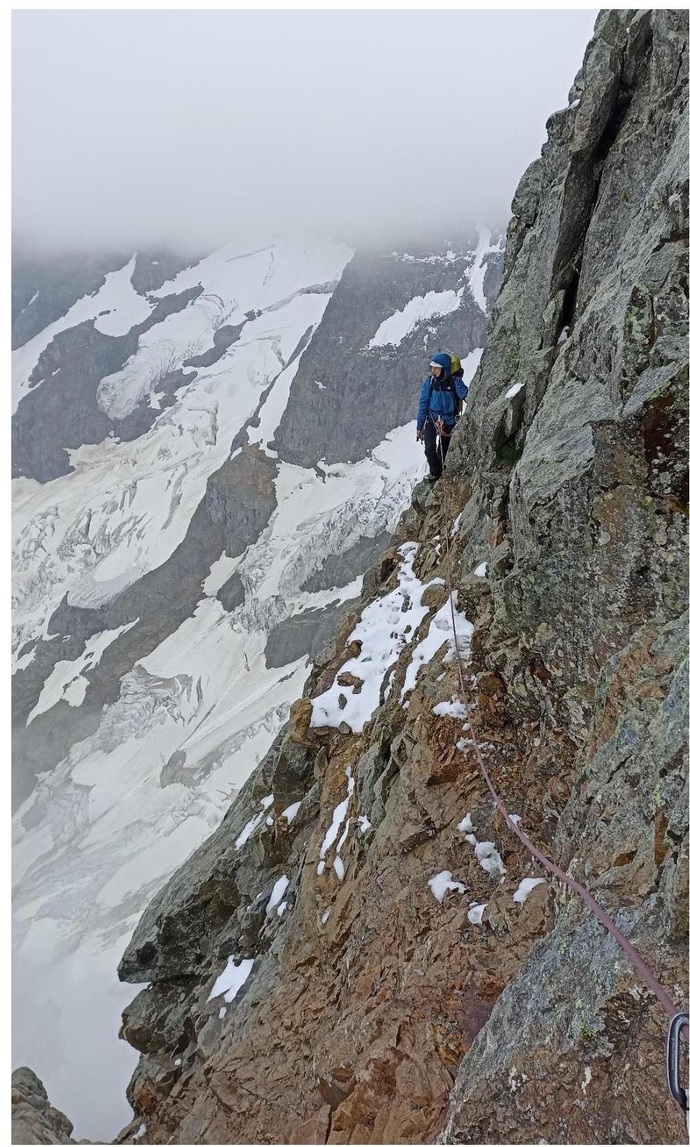
Photo #13 — R5–R6. Bypassing the gendarme with a yellow wall on the right via a narrow ledge (view from the R6 station)
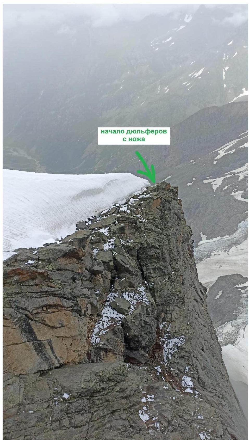
Photo #14 — View of the snow "knife"
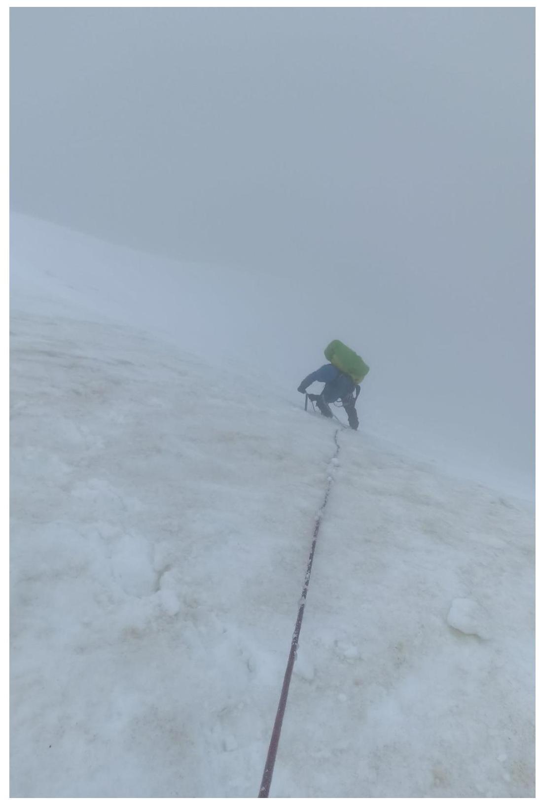
Photo #15 — R7–R8. Ascent along the snow "knife"
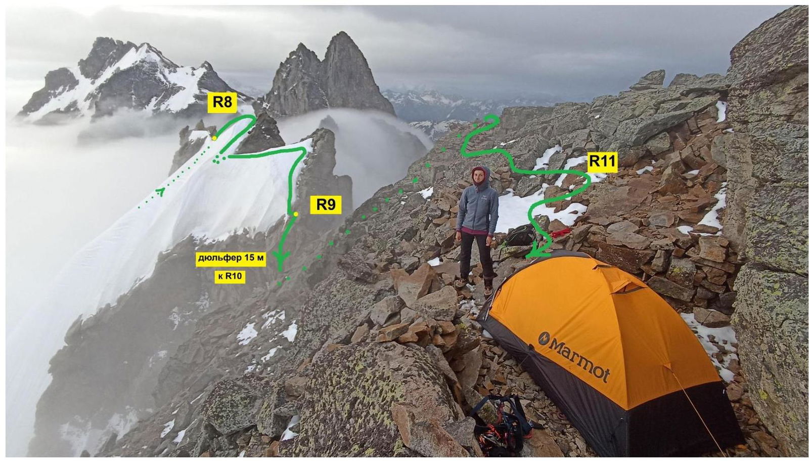
Photo #16 — Suitable tent platforms at R11. Overnight stays on July 20 and 21, 2024 (from here, they climbed to the summit tower without backpacks)
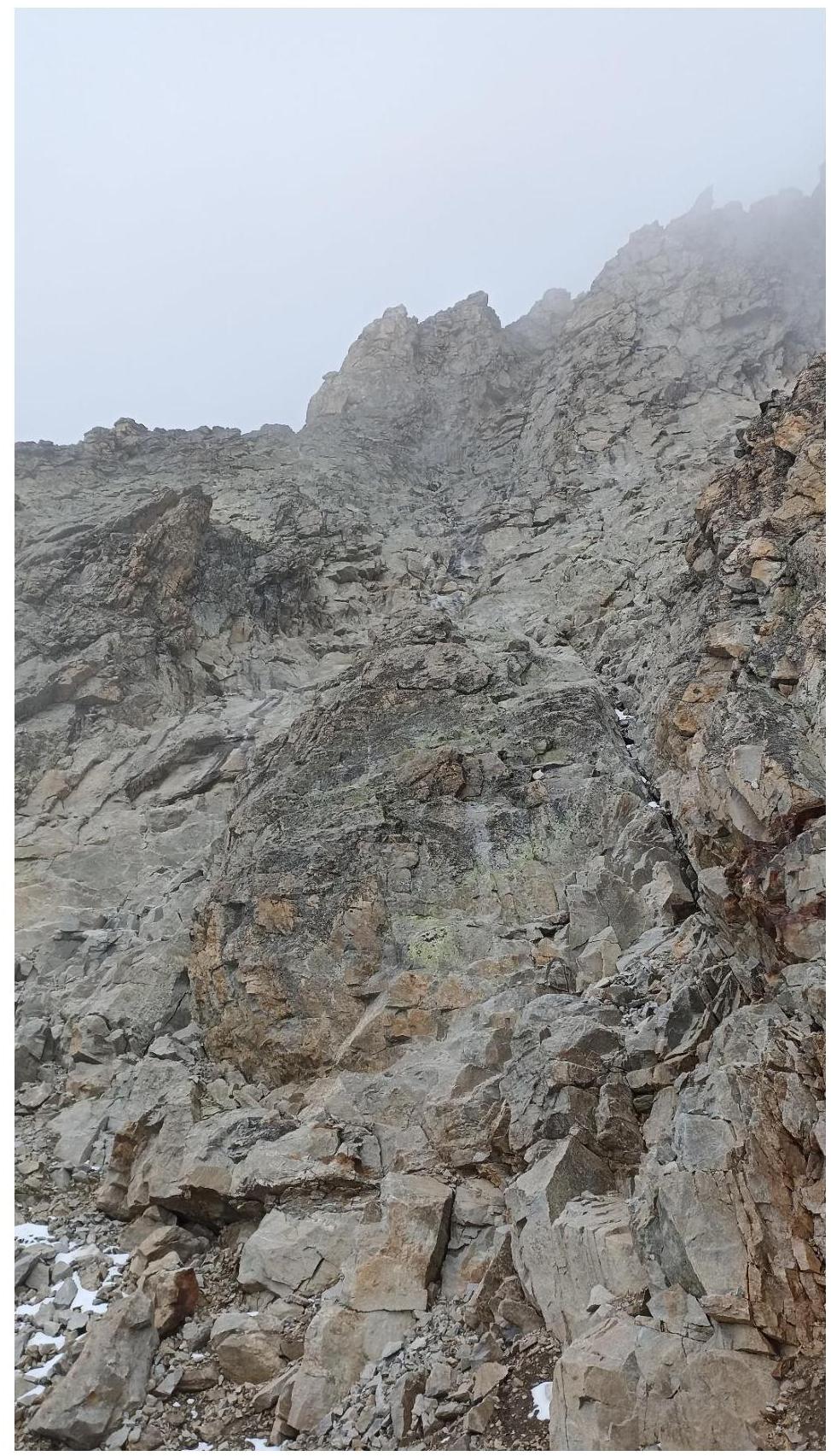
Photo #17 — View from the large ledge under the summit tower R11–R12
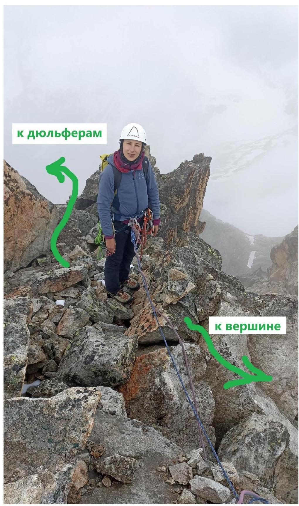
Photo #18 — R24–R25. Cairn on the route to the summit. From here, the rappels begin

Photo #19 — Summit :)
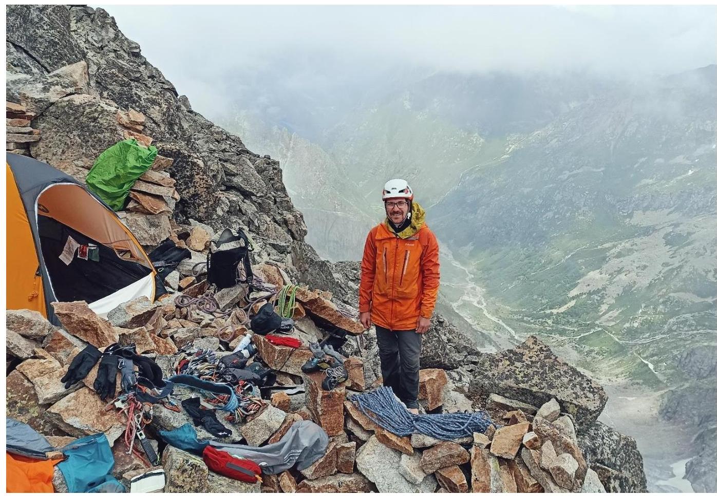
Photo #20 — R11. Weather improved. Resting and drying gear after descending from the summit
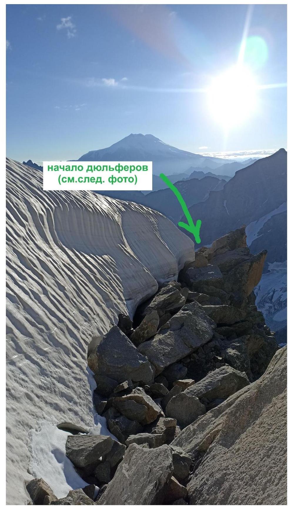
Photo #21 — Descent to the start of the rappels from the "knife" (a narrow platform on the rocks is visible, suitable for camping, with a bolt nearby)
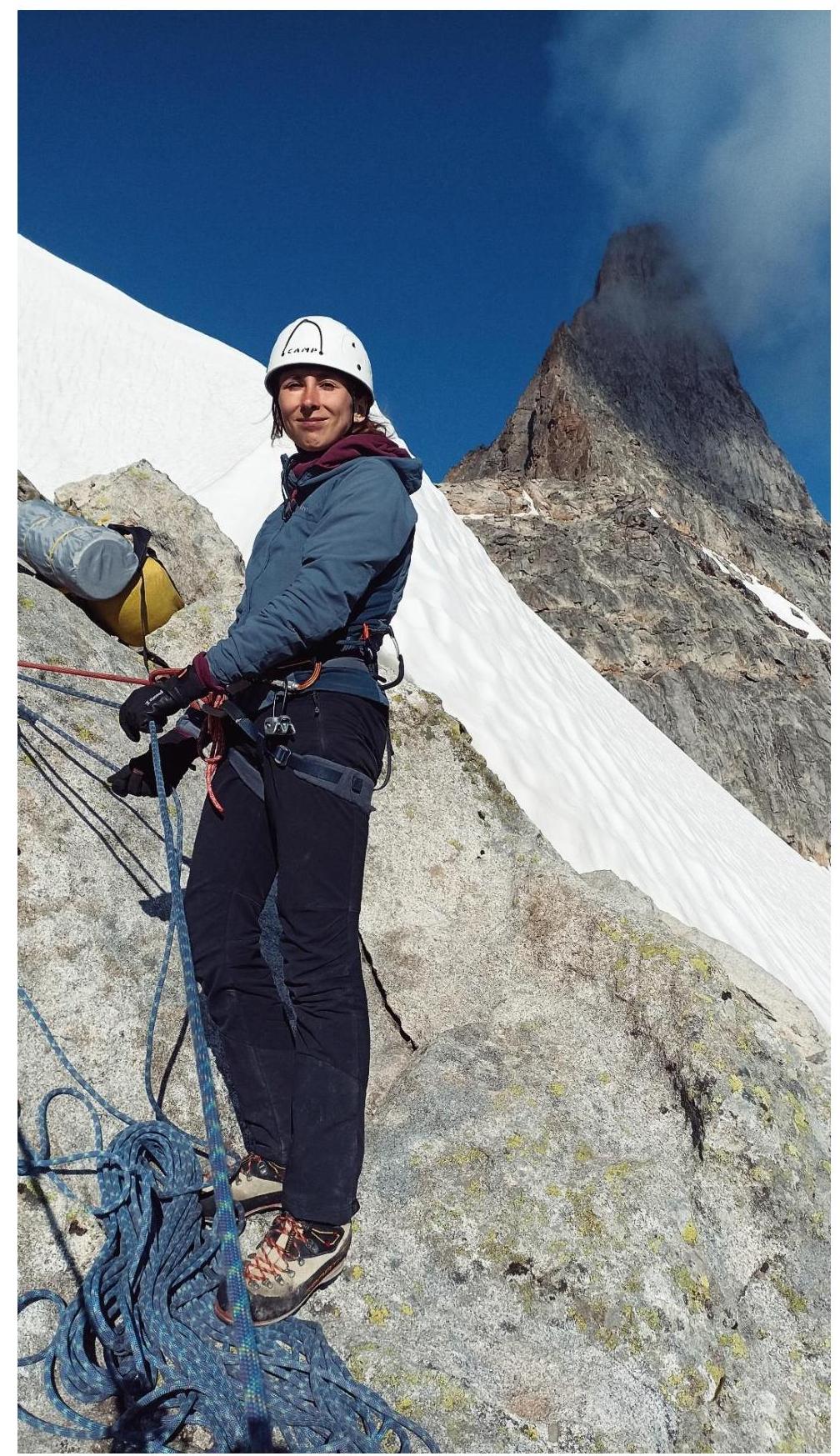
Photo #22 — First rappel station from the "knife"
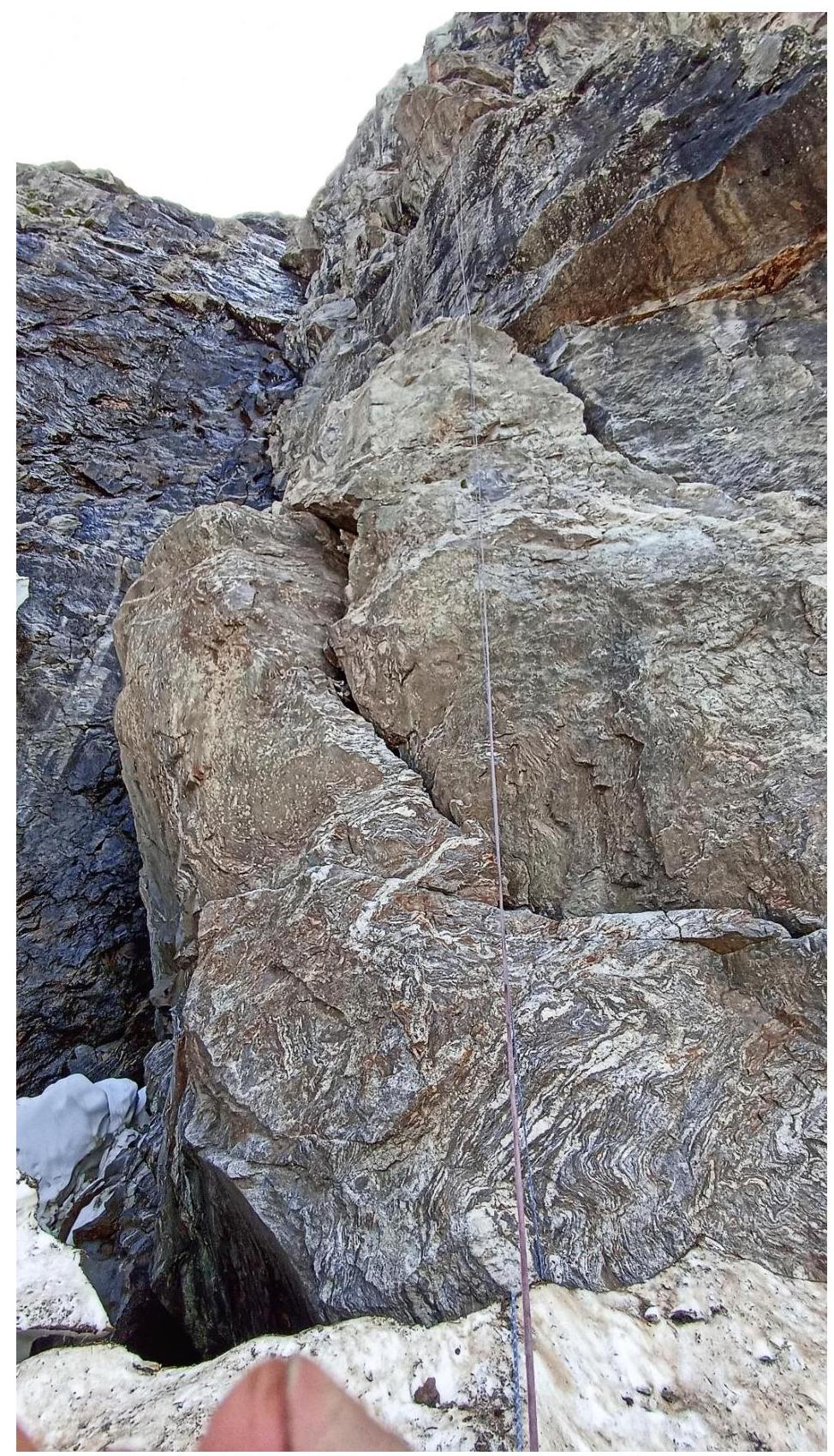
Photo #23 — Final rappel onto the glacier
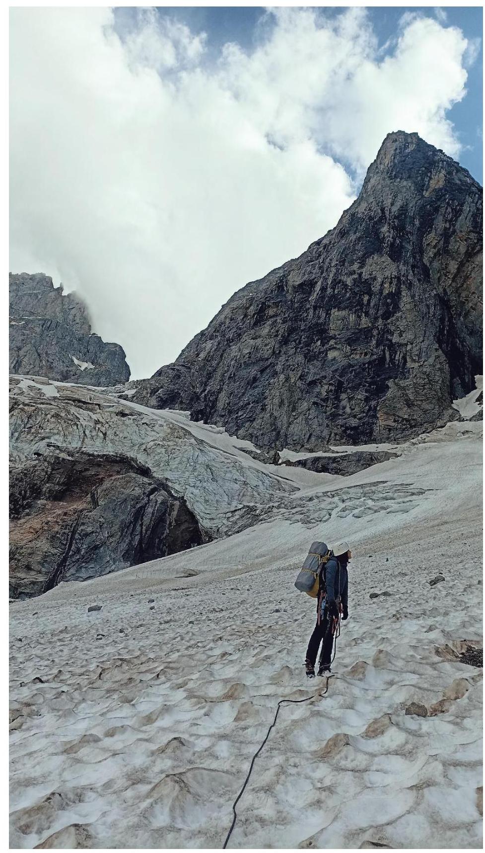
Photo #24 — Descent to the "green pocket." Observing the situation on the next route