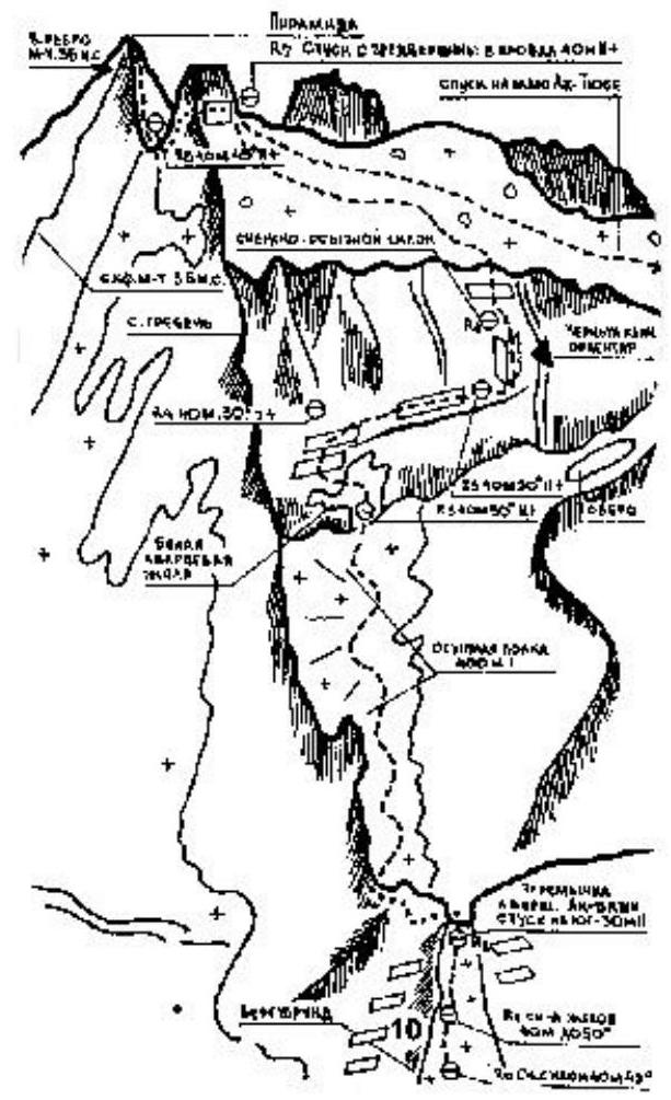
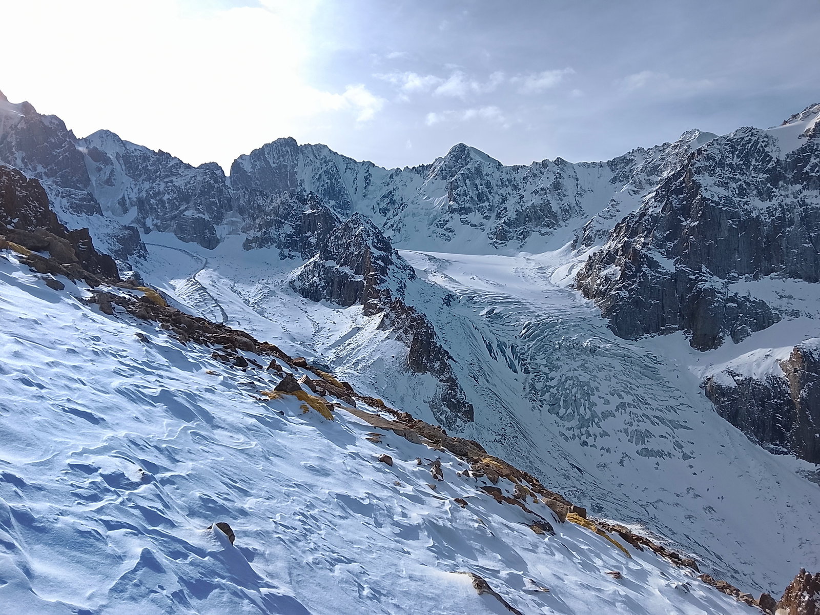
Activity Feed
Route Description: траверс с пер. Тогузак
The traverse route Muryntau-Toguzak, category 2B route, with a detailed description of the path and recommendations for climbers.
Тraverse of Muruntau - Toguzak with ascent to Toguzak, category 2B route. The beginning of the route description is given in the section on ascending Muruntau peak. From Muruntau peak, the path goes along the southwest ridge to the saddle between Muruntau and Toguzak peaks. Initially, there is a descent with a height loss of 250-300 m. The ridge is snowy, with rocks protruding in some places, including a significant gendarme (bypassed to the left). The ridge has cornices hanging to the east. To the west, the ridge drops steeply for about four hundred meters. Careful belaying is necessary. On the saddle itself, there is a gendarme that is tackled head-on. After the gendarme, there is an ascent along the northeast ridge of Toguzak peak. The ridge is mostly icy and steep. At the beginning of the ridge, proceed for 200 m, then deviate to the east and, with step-cutting, overcome the remaining section to the sub-summit, which is connected to the summit by a short ridge. Toguzak peak is a narrow ridge rising several meters above the sub-summit. Cairns are built on the sub-summit and the summit. From Muruntau peak to Toguzak peak, it takes 3-3.5 hours. Descent is done along the ridge going west from the summit. The descent route is described in the ascent to Toguzak peak.
Recommendations for Climbers
- Number of participants - no more than 10 people.
- Initial bivouac on the right moraine of Toguzak glacier.
- Departure from the initial bivouac at 4:00 AM.
- Equipment for a group of 4 people: a) 2 × 30 m main ropes; b) 3-4 rock pitons; c) 2 hammers.
Route Description: СВ кф.
Description of the route to the top of Ala-Archa with difficulty category III-IV, including details of the approach, ascent, and descent, as well as the necessary equipment.
Overnight stay at the GMS station on the Roluбина glacier, crossing the glacier, approach to the slopes of p. Ала-Арча near a large moraine. Start of the route:
- Along the scree shelf to the red gendarme on the right side.
- Then up the steep snowy couloir with a stone plug at the top, entering the shelf between the gendarme and the wall (30 m, 40–45°, Cat. diff.).
- Traverse along the scree side of the ridge — 50 m, Cat. diff.
- Ascend medium-difficulty rocks to the control point — 10 m, Cat. diff.
- Then straight up medium-difficulty rocks under the wall (80 m, Cat. diff.).
- Up the wall with piton belay, exit to the main shelf (40 m, 70°; III–IV cat. diff.).
Route Description: ЮЗ кф.
A description of a combined route to Ba'chechek peak in the Kyrgyz Ala-Too range with details on passing characteristic sections.
Brief explanation of the table
Peak Ba'checheke is located in the Kyrgyz ridge, Ak-Sai horseshoe, between the peaks Uchitel and Skryabin. The route is combined: the path to the summit goes through 103 counter-force, i.e., along the left (in the direction of travel) side of the rocky bastion. When the bastion ends, the counter-force of the bastion turns into the pre-summit ridge. The entire route can be conditionally divided into the following characteristic sections:
- Section 1
- Section 2
- Section 3 | Section | 0-1 | — Couloir 5 |
Route Description: центр. кф. 3 стены
Climbing passport for the ascent to the peak Baychechekey via the central counterfort of the 3rd wall, category 5A difficulty, with route description and technical details.
Ascent Passport
- Tian Shan, Kyrgyzsky Ridge, Ak-Sai gorge
- Pk. Baychechekhey, 4515 m, route via the central counterfort of the 3rd wall
- 5A cat. dif.
- Rock
- Route height difference: 760 m. Route length: 1430 m. Section lengths:
- V cat. dif. — 135 m.
- VI cat. dif. — 6 m.
Route Description: центр. кф. 3 стены
Ascent to the summit of Baychechekhey via the central counterfort of the West wall in Kyrgyz Ala-Too, complexity category 5B.
II CATEGORY II ROUTES
I. Category of First Ascents 2. Kirgizskiy Alatoo, Aksay gorge 3. p. Baychechekhey via the central counterfort of the Western wall 4. 5B approximately 5. Elevation gain 1080 m., length 1350 m Length of sections with 5–6 difficulty rating: 440 m. Average steepness of the main part of the route 72°, including 6th difficulty rating sections: 80–85° (60 m), 90–95° (20 m) 6. Pitons used: rock pitons
Route Description: правому кф. С стены
Report on the ascent of the team from the Kazakh Republican Council of the Spartak Volunteer Sports Society to Peak "Kyrgyzstan" via the north wall in 1963.
Report
On the ascent of peak "Kirgizstan" via the North face (claimed for the USSR Championship in the technically challenging category). And on the traverse of peak "Kirgizstan" with ascent via the North face (claimed for the Central Council Championship of the "Spartak" Volunteer Sports Society). Alma-Ata, 1963 www.alpfederation.ru
I. Introduction
The combined team of the Kazakh Republican Council of the "Spartak" Volunteer Sports Society on July 5-8, 1963, completed the ascent of peak "Kirgizstan" via the North face, claimed for the USSR Championship in the technically challenging category, and on July 1-3, they completed a traverse of the peak with ascent via the North face. Peak "Kirgizstan" is located in the upper reaches of the Salyk glacier in the Alamedin gorge, in the central part of the Kyrgyz Ala-Too range (see the Kyrgyz Ala-Too map) in the area of the Alamedin walls, very popular among climbers of Kyrgyzstan and Kazakhstan. The absolute height of the peak is 4840 m. It is the highest point of the latitudinal part of the Alamedin spur.
Route Description: С гребню
A description of the ascent route with a detailed analysis of the stages and an indication of the lengths and duration of individual sections.
200 m 30′
- R2 200 m 30′
- R3 200 m 45′
100 m
- R6 20 m 45′
200 m
- R5 40 m 50′
200 m
- R4 40 m 10′
Route Description: С гребню
Description of the ascent route along the northern ridge to the Peak 30 let VLKSM (Kyrgyz Range), complexity category 2B, ascent duration is about 7 hours.
Location. The Peak 30 let VLKSM is located on the ridge of the Jalamyshsky spur of the Kyrgyz Range and is its first peak to the north of the junction, where this spur branches off in a practically meridional direction from the Sokuluksky spur. To the north of the peak, its other neighbor, the Panfilov Peak, rises. From the summit to the east, a counterfors runs, which flows along the Yu. Adygene glacier, making a turn to the north. The entire northern slope of the counterfors is covered with a hanging glacier, which forms a small glacier at the foot. The western slope of the peak is steep and dissected by numerous rocky ribs made of crystalline chlorite schists. Externally, the summit resembles a regular three-faced pyramid and is well visible from the entire Adygene area.
Ascent via the North Ridge
The route, like the previous one, starts from the "Elektro" campsite and coincides with it in the initial part. After the slope of the Elektro peak turns to the west, you should not go to the left morene of the Yu. Adygene glacier. You need to continue moving along the same hollow in the southern direction, where the beautiful pyramid — the goal of the ascent — is almost always visible. The hollow leads to the valley between the Panfilov Peak and the Peak 30 let VLKSM, which forms two chambers here:
- the northern one
- the southern one, adjacent directly to the Peak 30 let VLKSM From this valley, the bottom of which is paved with morenic ridges, it is necessary to ascend to the ridge connecting the two mentioned summits. There are two variants of the path to this ridge:
- The first one: along the slope with an exit to the col (the 30 let VLKSM pass) from the southern chamber. The path to the pass runs along a loose scree.
Route Description: СЗ гребню
Ascent to Peak M. Tourist via the rocky ridge with a detailed description of the challenging route and technical details.
Ascending Peak Maly Tourist via the Northwest Ridge (Category 3B)
We leave the base camp, located on a sandbar in front of the tongues of Gl. Researchers and Chon-Turasu, at 10:30. Moving along the sandbar alongside a stream running near the tents, we approach the tongue of Gl. Chon-Turasu and begin to bypass it from the left (north) along the same stream. To our left are:
- heaps of enormous old moraines
- moraines lying on dead ice The stream disappears into the stones, and we come to a depression located between the scree slopes of the ridge between Pik Skalisty and Pik Maly Tourist to the north and the modern terminal and lateral moraines of Gl. Researchers to the south (old lateral moraines are absent). A large stream with clear water flows along the flat bottom of the hollow. The stream is not deep, and we cross it several times via stones. Soon the stream turns right, while we continue moving along the hollow. At 12:30, we ascend to a rampart (its upper part is covered with calcite boulders) blocking the hollow and enter a flat and almost horizontal gravel area about 150 m long and 30–50 m wide. After climbing the next rampart (from here, it's easy to ascend to the glacier's surface), we enter a second almost horizontal area. The area stretches for 400–500 m and ends under a powerful monolithic buttress descending from the ridge's bend before Pik Maly Tourist. The lower part of the area is silted, with a small lake. The lake is fed by:
- one large stream,
- several small streams from the slope of Pik Skalisty. The buttress descending from the ridge's bend cuts into the glacier (as do several other buttresses located higher along the glacier) and deflects it to the south. At the same time, it "dumps" the glacier's lateral moraine closer to its middle. This explains the formation of such large depressions and the absence of a lateral moraine on the glacier.
Route Description: ЮВ стене
Description of the 4A category difficulty route to Mayakovsky Peak via the Southeast Wall, including recommendations and necessary equipment for a group of 4 people.
Mayakovsky 4A cat. via South-Eastern wall (Savukhin's route)
Route description. The approach to the South-Eastern wall of peak Mayakovsky is through Ordzhonikidze or Antikainen passes. Special attention should be paid to the descent from Antikainen pass down a steep snowy slope. When moving, strictly stick to the middle of the slope (rockfall). Go around the massif of Antikainen peak and Отечественной Войны peak, reach the South-Eastern wall of peak Mayakovsky. Initial bivouac is on the moraine of the Eastern Ordzhonikidze glacier. To study the rockfall regime, spend two days under the south-eastern wall. Start the ascent very early. The ascent to the wall is via easy rocks, alternating with talus. Then there is a section of slabs with a steepness of 25–30° (first control point), which lead directly to the foot of the south-eastern wall of the peak. At the first stage, move along a vaguely expressed crevice, the walls of which are monolithic, with a steepness of 75–80°. The first climber has to ascend to the full length of the rope, extremely cautiously, deviating slightly to the right. Only after 30 m, on a small ledge, above which there is a 3–4-meter wall, is there a crack (piton belay). Only one person can be taken to the platform.