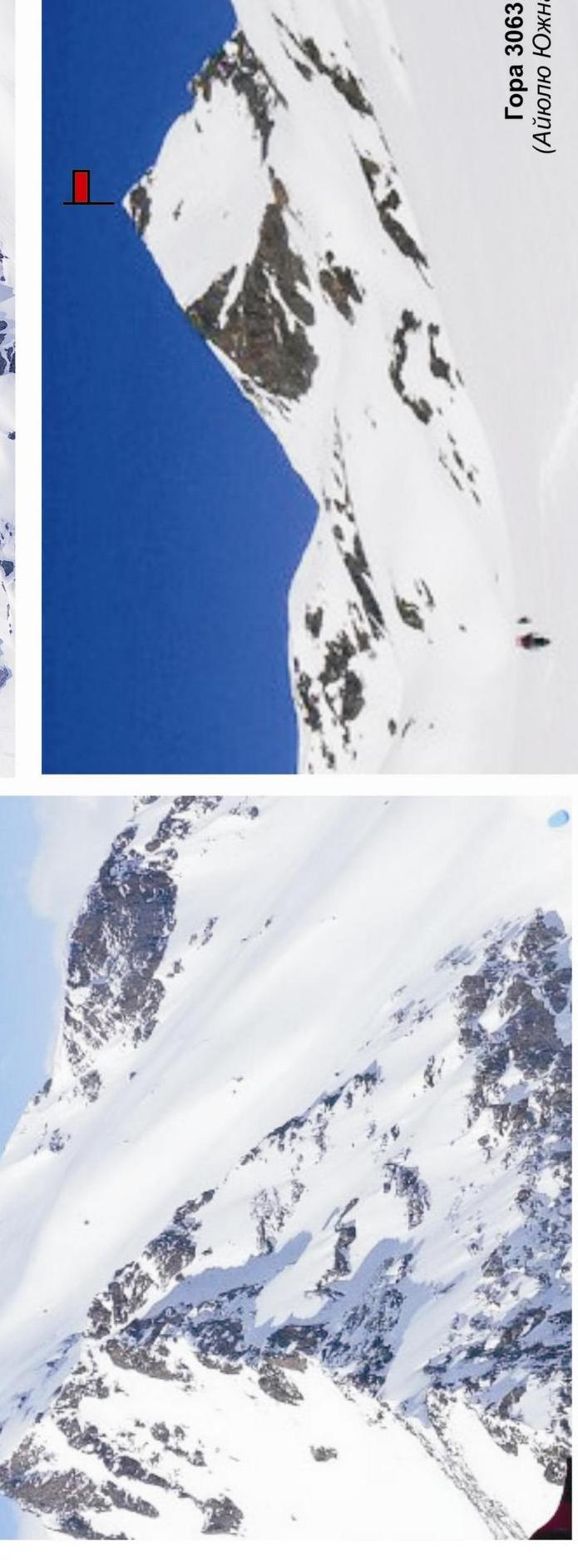
Peak 3063 (Aiyuliu Yuzhnaya)
Route: via the eastern buttress
Difficulty level - 2A (2B?) Combined
Leader: A. Lyapun
Western Caucasus, Arkhyz, Irkis valley, northeastern spur of the Arkhsar ridge (Gabul ridge), Aiyuliu tract
Section in KMGV - 2.1.
Report
On the first ascent of the mountaineering route to peak 3063 (Aiyuliu Yuzhnaya) as part of mountaineering competitions: "Third stage of the cup of NP 'Sauk-Pai Club of Northern Travelers' - 'Irkis-2015'" (class "First ascents") in May 2015.
Route: via the northern ridge
Difficulty level - (approximately) 2A (2B?) combined
Region: Karachay-Cherkess Republic
Mountain country: Western Caucasus
Gorge: Irkis valley
Ridge: northeastern spur of the Arkhsar ridge (Gabul ridge), Aiyuliu tract
Peak: 3063 m (Aiyuliu Yuzhnaya)
Route: via the northern ridge
Difficulty level: 2A (2B?) category (combined) (approximately)
Prepared by: A. Lyapun, S. Zhuravlev, May 2015.
Aiyuliu tract
The Aiyuliu tract is located in the upper reaches of the Belaya River (Aiyuliu) - a left-bank tributary of the Psysh River in the Irkis valley, on the eastern slope of the southern part of the northeastern spur of the Arkhsar ridge (Gabul ridge).
The Aiyuliu tract is a pronounced mountain horseshoe formed by the southeastern and eastern spurs of the Gabul ridge. The nodal peaks and passes do not have official names, but each has traditional names established in guidebooks and guide-books. The mountain horseshoe of the Aiyuliu tract (from left to right):
- 2989 (peak of the Caucasian Mountain Society)
- Tolyatti pass
- 3145 (Dorbun-Kaya)
- Dorbun pass
- 3213 (Dukka-Bashi)
- Oleny pass
- 3063 (Aiyuliu Yuzhnaya)
- Aiyuliu pass
- 3118 (Aiyuliu)
The ascent to the tract goes along a mountain trail along the Belaya River (Aiyuliu) to the lake, which is the source of the river. There is a shepherd's hut near the lake, used by shepherds in the summer. In the off-season, the hut can be used by climbers as a temporary shelter in case of bad weather.
A characteristic feature of the peaks of the Aiyuliu tract is a long approach with a sharp gain in height and rock towers made of dense rocks with small but technically complex sections.
- Increased avalanche danger during the off-season
- Abundance of snow-hanging cornices on rocky ridges
Due to the large height difference (over 1500 m) from the Irkis valley, ascents to the peaks of the Aiyuliu tract are conveniently done with an approach. The campsites in the Aiyuliu tract are comfortable and have drinking water available year-round.
As part of the mountaineering competitions: "3rd stage of the cup of NP 'Sauk-Pai - 2015'" (Class "First ascents"), three first ascents of routes were made to the peaks of the Aiyuliu tract:
- peak 3118 (Aiyuliu) via the southern ridge - 1B category
- peak 3063 (Aiyuliu Yuzhnaya) via the northern ridge - 2A (2B?) category
- peak 3063 (Aiyuliu Yuzhnaya) via the eastern buttress - 3A category
In the Aiyuliu tract, due to the high avalanche danger of the slopes, the mountain 3214 m (Dukka-Bashi) - the highest peak of the tract - remained undeveloped. For the same reason, ascents to the peaks 2989 m (peak of the Caucasian Mountain Society) and 3145 m (Dorbun-Kaya) were made from the neighboring gorge - the Amanaus River valley.
Note: reports on the completed first ascents are attached.
Promising mountaineering routes for development in the Aiyuliu tract:
- route 1
- route 2
- route 3
- route 4
- route 5
- 3214 m (Big Dukka) - via the NE ridge (approximately 1B-2A).
- 3214 (Big Dukka) - via the SE buttress (approximately 1B-2A).
- 3087 (Big Dukka SE) - via the N slope (approximately 1B-2A).
- 3087 (Big Dukka SE) - via the NE ridge (approximately 1B-2A).
- 3117 (Dorbun-Kaya Gl) - via the SW ridge (approximately 2A-2B).
- 3117 (Dorbun-Kaya Gl) - via the N buttress (approximately 3A-3B).
- 3117 (Dorbun-Kaya Gl) - via the NW ridge (approximately 2A-2B).
- 3117 (Dorbun-Kaya C) - via the N buttress (approximately 3B-4A).
- 2089 (peak of the Caucasian Mountain Society) - via the NE ridge (approximately 2A-2B). FRAGMENT OF MAP M: 1 cm - 500 m. APPROACH SCHEME TO THE AIYULIU TRACT

Western Caucasus. Arkhyz mountain region. Irkis valley. Northeastern spur of the Arkhsar ridge (Gabul ridge). Belaya River (Aiyuliu) valley. Aiyuliu tract. Overview of promising mountaineering routes
Photo from the Aiyuliu tract. May 2015 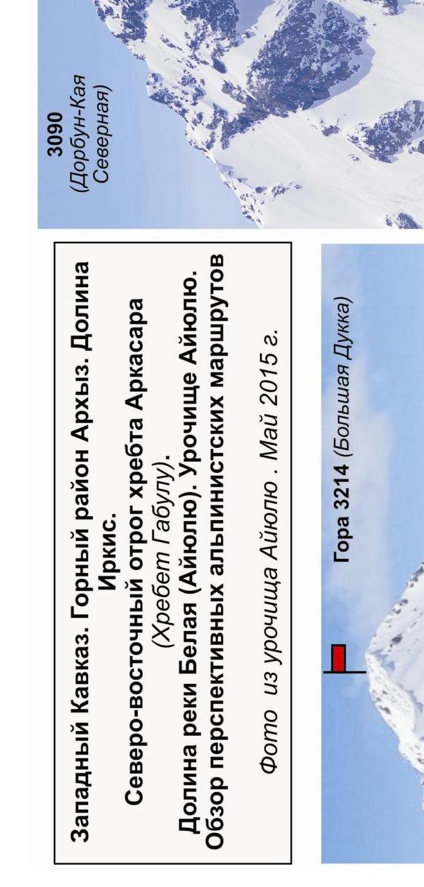
Passport
- Section number according to KMGV - 2010 - 2.1.
Western Caucasus, mountain region - Arkhyz, Irkis valley, northeastern spur of the Arkhsar ridge (Gabul ridge), Aiyuliu tract
- Name of the peak: 3063 (Aiyuliu Yuzhnaya)
- Height: 3063 m
- Route: via the northern ridge
- Difficulty category: 2A category
- Character of the route - combined.
- Height difference of the route:
From the base camp (confluence of the Belaya River (Aiyuliu) and the Psysh River) - 1300 m. From the shepherd's hut in the Aiyuliu tract - 750 m
- Length of the route:
Total length (from the shepherd's hut) - 1800 m. Technical part (from R1 - Aiyuliu pass) - 620 m
- Length of sections with the highest category:
- 1 category - one section - 300 m
- 2 category - two sections - 260 m
- 3 category - one section - 60 m
- 4 category - 0 sections - 0 m
- 5 category - 0 sections - 0 m
- 6 category - 0 sections - 0 m
- Average steepness: total route - 35°
technical part - 65°
11. Number of pitons used:
Total used on the route:
- rock pitons - 4
- chocks - 8
- stationary pitons - 0
- ITO - 0
- removable pitons - 0.
Left on the route: total - 0; including stationary pitons - 0.
- Exit to the route (from the shepherd's hut) - 7:00, May 2, 2015.
Reached the summit - 12:00, May 2, 2015. Returned - 15:00, May 2, 2015.
- Team's travel time: - 8 hours.
- Leaders: sports group - Kuznetsov (Moscow, 3rd sports category), training and sports department - Alexander Lyapun (Master of Sports of the USSR, instructor-methodologist of the 2nd category, Sevastopol).
Participants: 1. Sports group - Maltsev Fedor (Moscow, 3rd sports category).
- Training and sports department - Zuev Konstantin (Samara, 3rd sports category), Mikhailova Lyubov (Samara, 3rd sports category), Paramonchev Alexander (Samara, 3rd sports category).
- Coach: Zhuravlev Sergey Vasilievich (Candidate for Master of Sports, instructor-methodologist of the 1st category).
Analogous routes:
- ViaTau S ridge - 2A category (Adyl-Su)
- Nikolaev peak - via the eastern wall 2A category (Tsey)
- Shalbuzdag (2nd tower) from the south - 2A category.
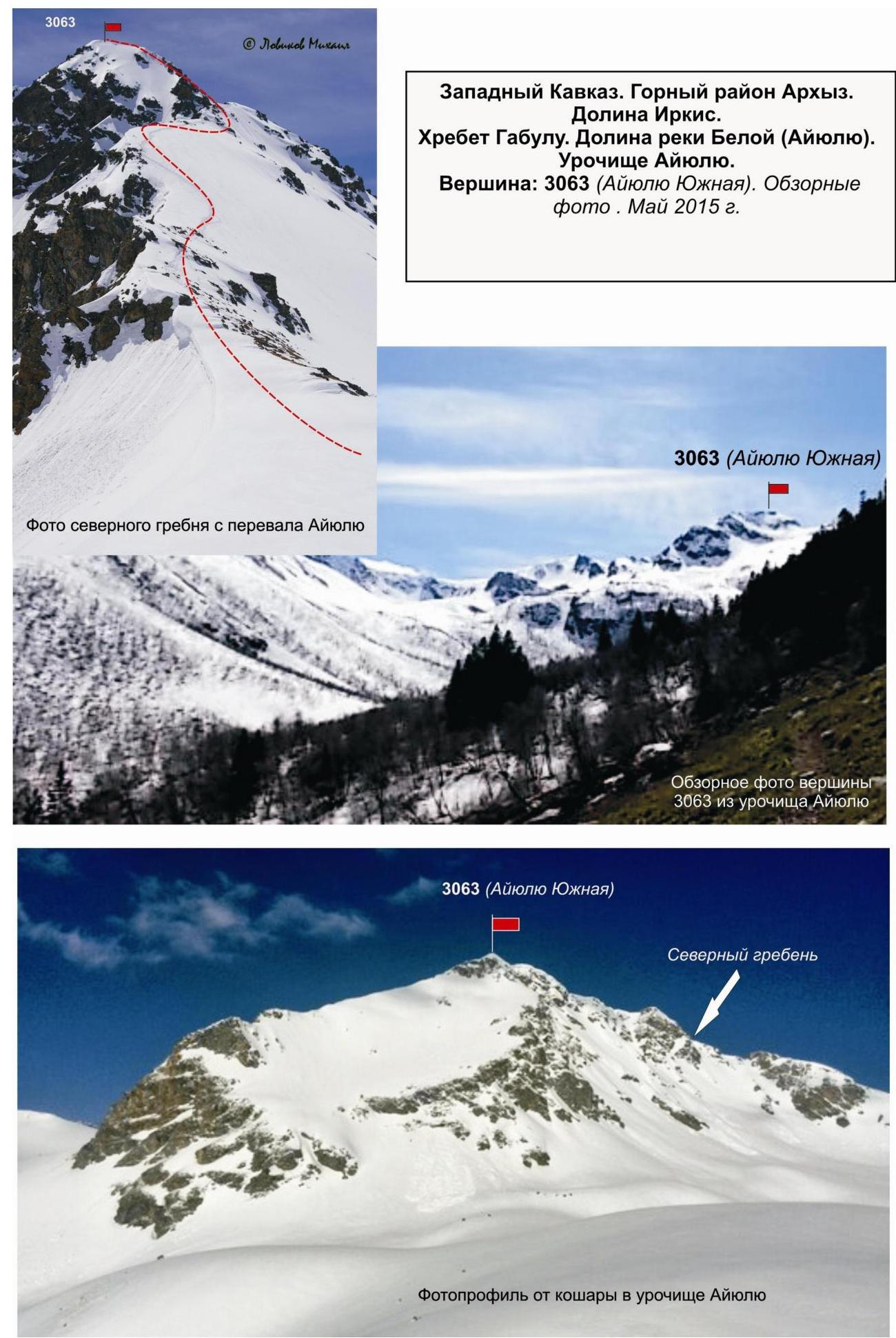
Description of the peak Peak 3063 (Aiyuliu Yuzhnaya) is located in the southern part of the Gabul ridge, in the upper reaches of the Belaya River (Aiyuliu) valley, in the Aiyuliu tract between the passes:
- Aiyuliu (north)
- Oleny (south)
The peak is marked on the map-kilometer of the General Staff of the Russian Federation with a height mark. The name of the peak Aiyuliu Yuzhnaya (as well as the passes) is unofficial, given for identification.
Peak 3063 (Aiyuliu Yuzhnaya) in the Aiyuliu tract is easily identifiable due to the pronounced depressions (passes).
Description of the route
Route: "Via the northern ridge" - a ridge characteristic training and sports combined route of 2A (2B?) category, with a full range of natural obstacles corresponding to routes of this level.
The northern ridge:
- is easily identifiable;
- is simple to find;
- the route is logical from the pass to the summit;
- does not cause difficulties in orientation.
Equipment
For the ascent, the sports department consisting of 4 people requires the following special equipment:
Personal:
- Standard equipment
- Crampons
- Ice axe
Group:
- Main rope 10 mm - 2×50
- Rock hammer - 2 pcs.
- Rock pitons - 10 pcs.
- Chock elements - 12 pcs.
- Friends - 6 pcs.
- Ice screws - 0 pcs.
- Quickdraws - 16 pcs.
- Slings - 4 pcs.
Approach
From the base camp, located near the confluence of the Belaya River (Aiyuliu) and the Psysh River, ascend along the left (orographic) bank of the Belaya River (Aiyuliu). Then, along the way, to the right, to the shepherd's hut in the Aiyuliu tract. The approach takes 3-4 hours.
The ascent is made from the shepherd's hut. The approach from the hut to the beginning of the route and the place of organizing the links on the saddle of the Aiyuliu pass takes 1-1.5 hours.
Technical part
The beginning of the technical part of the route is the saddle of the Aiyuliu pass (in the tourist classification, the pass is 1A category). The saddle is clearly pronounced. Near the cairn, there is a memorial plaque dedicated to the Heroes - Defenders of the Caucasus during the Great Patriotic War.
Then, along a gentle snow slope, ascend (to the left along the way) to the narrowing of the ridge and its transition to a rocky one. The "Three Gendarmes" section is easily determined by three rocky gendarmes located on the northern ridge. The gendarmes are passed "head-on". The passage does not cause difficulties, as the abundance of rock relief on the ridge allows using the relief for insurance:
- bends
- large loops thrown over ledges
A certain difficulty is caused by organizing the descent using a rappel from the third gendarme to the saddle. From the snow-covered saddle, there is a key section of the route.
KEY SECTION of the route: a rocky wall - a monolith with a chimney leading to the summit tower. The key section is passed with alternate insurance; for training departments, it is possible to organize a belay.
Places for stations are convenient:
- at the beginning of the key section,
- at the top, upon completion of the key section,
- there are reliable large ledges.
The section can be divided into two:
- passing the wall,
- passing the chimney.
At the base of the chimney, there is a convenient rocky ledge for organizing insurance and self-insurance, allowing 3-4 participants to gather.
After passing the wall with the chimney, the ascent to the summit does not cause difficulties: the snow ridge turns into a snow- and rocky summit dome. The exit to the summit is on a shortened rope and simultaneous.
Peak 3063 (Aiyuliu Yuzhnaya) is clearly pronounced. The cairn is located above the official height mark (on the elevation of the slope to the south, height 3078 according to GPS).
Descent: along the northern slope into the northern cirque. Then, along the snowy cirque, traverse at a relatively large distance (possibility of rockfall and avalanches) towards the Aiyuliu pass. The height difference is small - 100-150 m. Then:
- Ascend to the Aiyuliu pass
- Descend to the shepherd's hut in the Aiyuliu tract
Recommendations to the instructor
Due to the accessibility in orientation, the route can be recommended for both training and sports departments (NP-2) and for independent sports groups of разрядники (SP-1, 2) conducting leadership or training ascents.
Time spent on the route for a training and sports department of разрядники of average preparation level (SP-2) - 8-10 hours.
Western Caucasus.
- Arkhyz mountain region
- Irkis valley
- Gabul ridge
- Belaya River (Aiyuliu) valley
- Aiyuliu tract
Peak: 3063 m (Aiyuliu Yuzhnaya) Route: "Via the northern ridge" Approximately: 2A (2B?) category (combined)
Scheme in UIAA symbols. May 2015 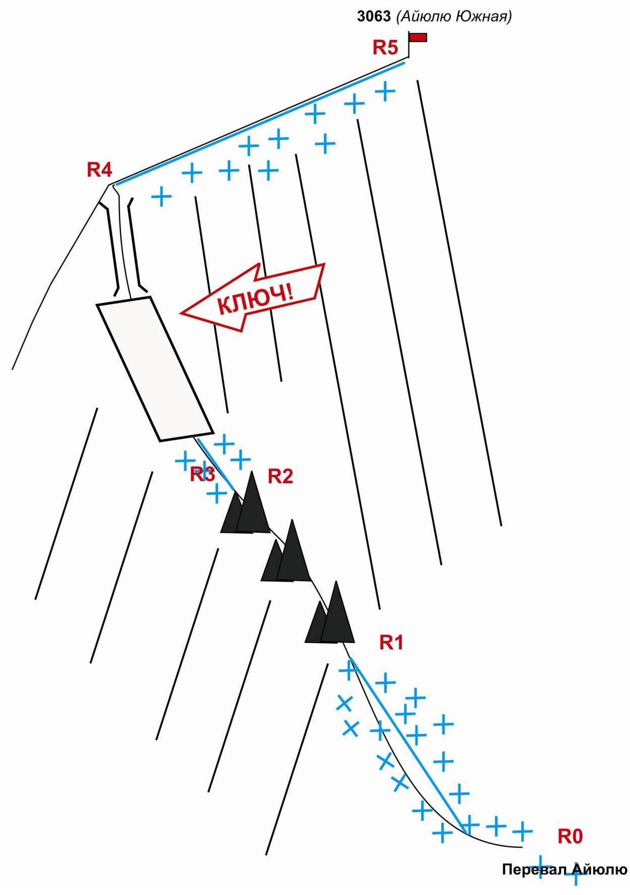
Western Caucasus. Arkhyz mountain region. Irkis valley. Gabul ridge. Aiyuliu tract. Peak 3063 m (Aiyuliu Yuzhnaya). Route: via the northern ridge. Category: 2A (2B?) category, combined (approximately)
Table of natural obstacles on the route
| APPROACH | From the shepherd's hut in the Aiyuliu tract, along the way to the right towards the Aiyuliu pass (40 min). Then, from the cirque, ascend to the Aiyuliu pass. The saddle of the pass is well pronounced. On the pass, near the cairn, there is a memorial plaque dedicated to the Defenders of the Caucasus during the Great Patriotic War. The technical part begins from the pass cairn (places of organizing the links). | |||
|---|---|---|---|---|
| R0 | Place of organizing links: Aiyuliu pass. | |||
| Characteristics of sections | Length | Steepness | Difficulty level | Notes |
| Section R0–R1. Aiyuliu pass - rocky ridge. Snow. Snow-covered wide ridge. Movement in links on a shortened rope. | 300 | 15-30 | 1.1+ | Used: pitons/chocks: 0/0. No pitons or chocks left. |
| Section R1–R2. Passing the rocky section "3 gendarmes". Rocks. Jagged ridge with three pronounced gendarmes. Gendarmes are passed "head-on". | 200 | 45°, on individual sections up to 70° by 35 m | 2-, 2+ | Used: pitons/chocks: 0/0. No pitons or chocks left. |
| R2–R3. Descent to the saddle. Rocky slabs. Descent using a rappel. Interaction of links. | 60 | 65 | 2+ | Used: pitons/chocks: 0\0. No pitons or chocks left. |
| :--: | :--: | :--: | :--: | :--: |
| R3–R4. Passing the key section. Exit to the pre-summit rocky tower. KEY SECTION of the route - a steep, smooth rocky wall (monolith). Under the wall, there is a convenient station. Movement - interaction of links with the organization of a belay. | 60 | 60 | 3+ | Used: pitons/chocks: 4\8. No pitons or chocks left. |
| R4–R5. Summit dome. Wide snow-covered ridge. Simultaneous movement on a shortened rope. | 200 | 25 | 1 category | Used: pitons/chocks: 0\0. No pitons or chocks left. |
| R5 - summit 3063 | Summit - a pronounced rocky dome, cairn in the upper left part. | |||
| DESCENT | Along the northern slope to the snowy fields of the northern cirque. Then, along the plateau of the northern cirque, towards the Aiyuliu pass. Ascent to the Aiyuliu pass and descent from the pass to the shepherd's hut (1.5 hours). |
Total:
Route length
(without approach) - 820 m
Average steepness:
total route - 35°, technical part - 65°
Technical sections:
1 category - two sections - 300 m, 2 category - two sections - 260 m, 3 category - one section - 60 m
Used/left:
Pitons - 4/0, chocks - 8/0 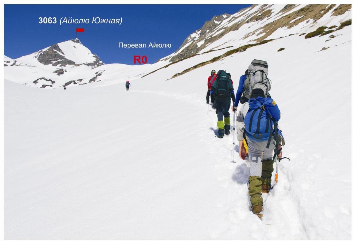
Approach from the shepherd's hut to the Aiyuliu pass 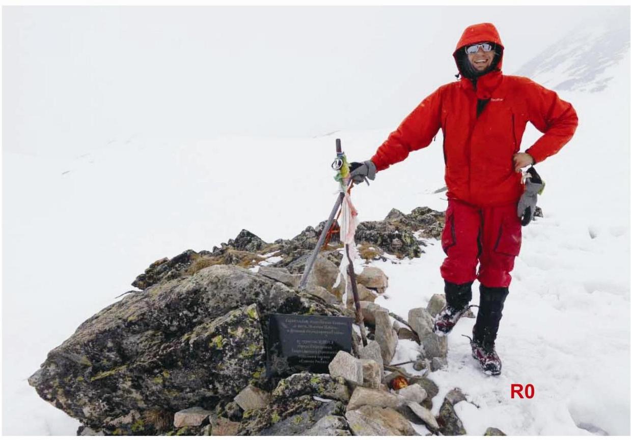
Aiyuliu pass - the beginning of the technical part of the route. Western Caucasus. Arkhyz mountain region.
- Irkis valley
- Gabul ridge
- Belaya River (Aiyuliu) valley
- Aiyuliu tract
Peak: 3063 m (Aiyuliu Yuzhnaya). Photo of the northern ridge and the "Three Gendarmes" section. May 2015 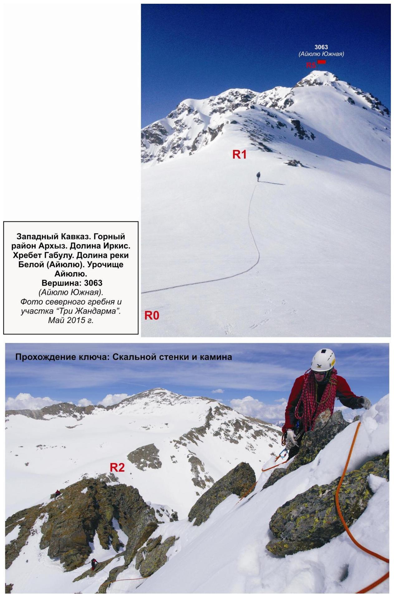
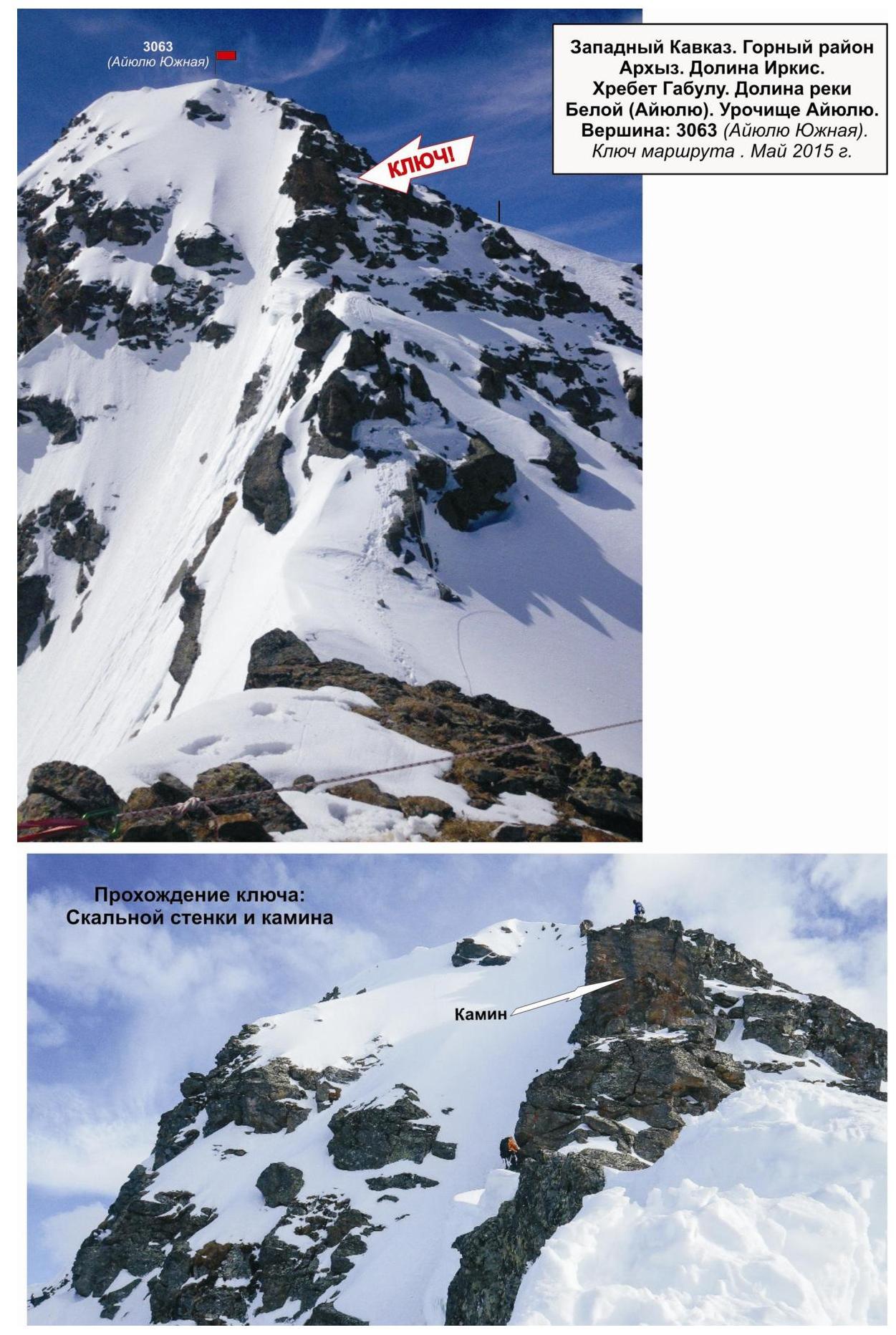
Passing the key section: rocky wall and chimney
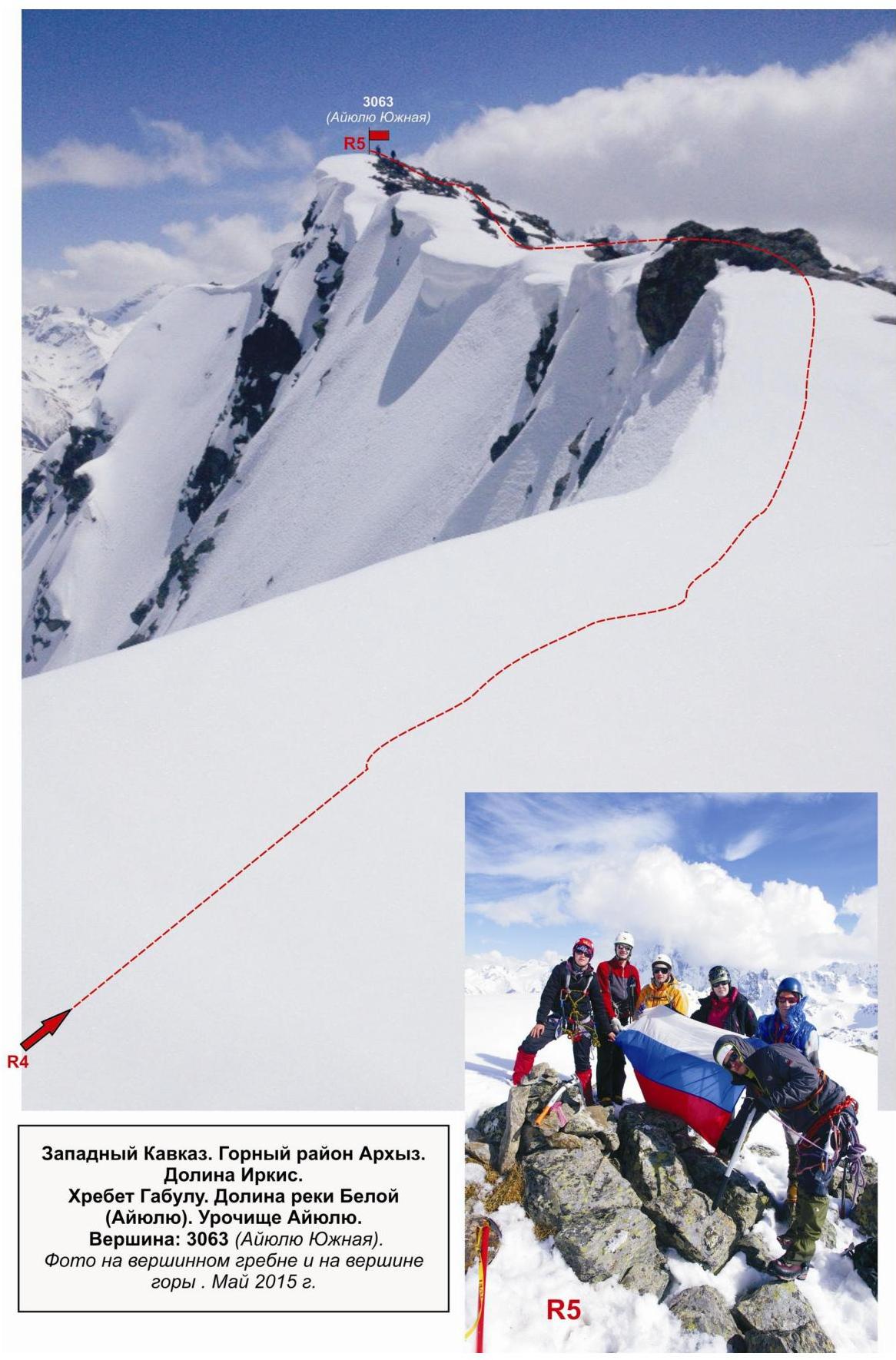
Western Caucasus. Arkhyz mountain region. Irkis valley. Gabul ridge. Belaya River (Aiyuliu) valley. Aiyuliu tract. Peak: 3063 m (Aiyuliu Yuzhnaya). Photo on the summit ridge and on the peak. May 2015


