www.alpfederation.ru↗ Ascent Passport
Region — Subpolar Urals. Research Ridge.
Gorge — Mountain horseshoe of Oleny stream valley
Section number according to KMGV-2001 – 8. "Other mountain systems, massifs"
Peak name — Pobednaya
Height — 1582
Route name — via the South Ridge
Complexity category — Proposed category — 1B
Route character: Rocky
First ascent
Height difference — 980 m
Route length — 2000 m
Sections of 5th complexity category — none
6th complexity category — none
Average steepness of the main (technical part) of the route — 45°
Average steepness of the entire route — 33°
Pitons were not used
Team's travel hours
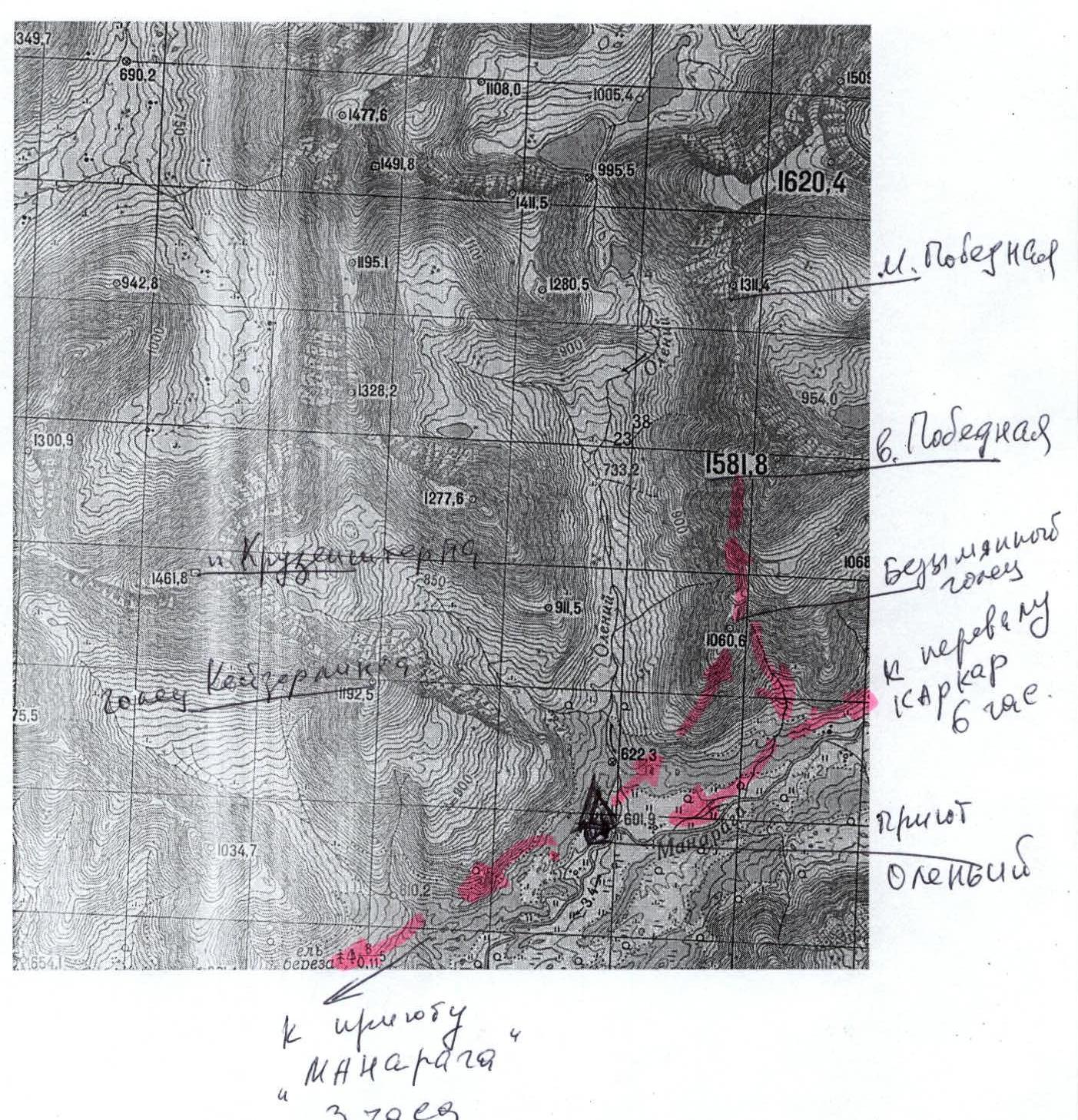
- Approach from Oleny shelter — 50 min.
- Ascent from the bivouac near Oleny shelter — 6 hours.
Leader: Popov M. N. (Syktyvkar, 2nd sports category) + 2
Zhuravlev S. V. (CMS, instructor 2nd category) + 10
Coach: Zhuravlev Sergey Vasilyevich, CMS, instructor 2nd category.
Departure on the route — 7:00, July 10, 2005.
Reaching the summit — 13:00, July 10, 2005.
Return to the base camp — 15:30, July 10, 2005.
Organization: (Youth Scientific-Sports Expedition of the Alpinism Federation of the Komi Republic and the Yugyd Va National Park "Pobeda – 2005")
Contact: Zhuravlev Sergey Vasilyevich, Syktyvkar 167000, Internatsionalnaya str., 97, apt. 12. Phone: 24-24-91. E-mail: Zhur58@rambler.ru
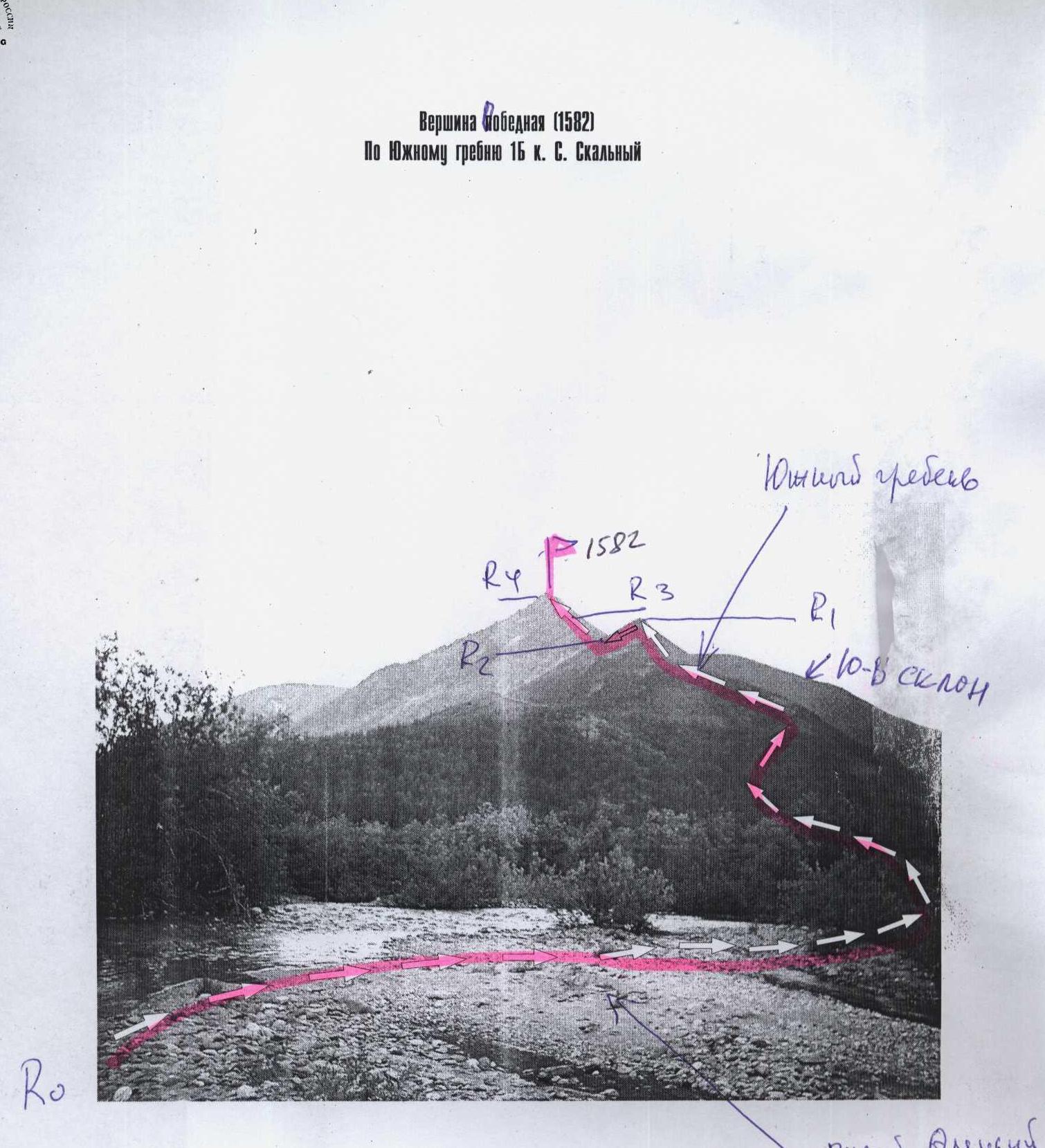
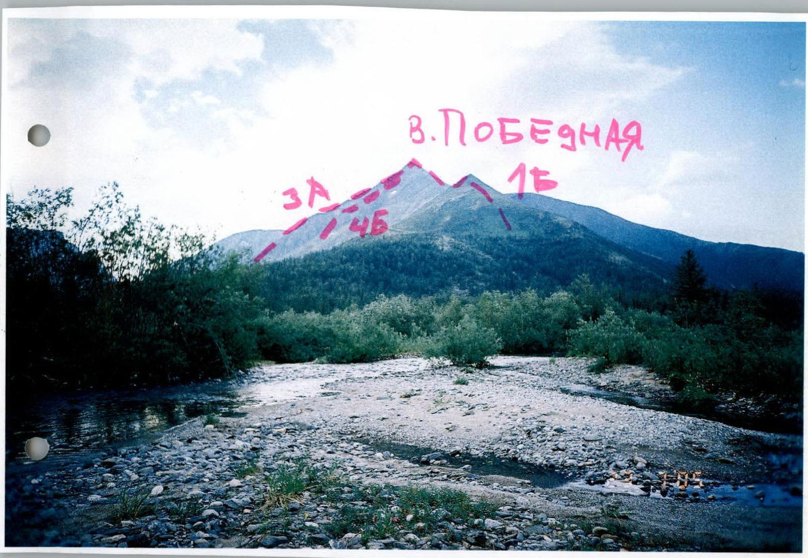
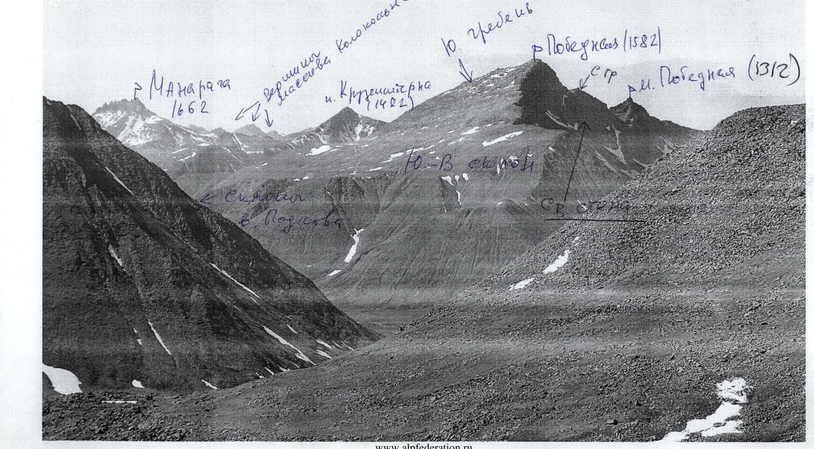
Photo from the west, from the mouth of Oleny stream
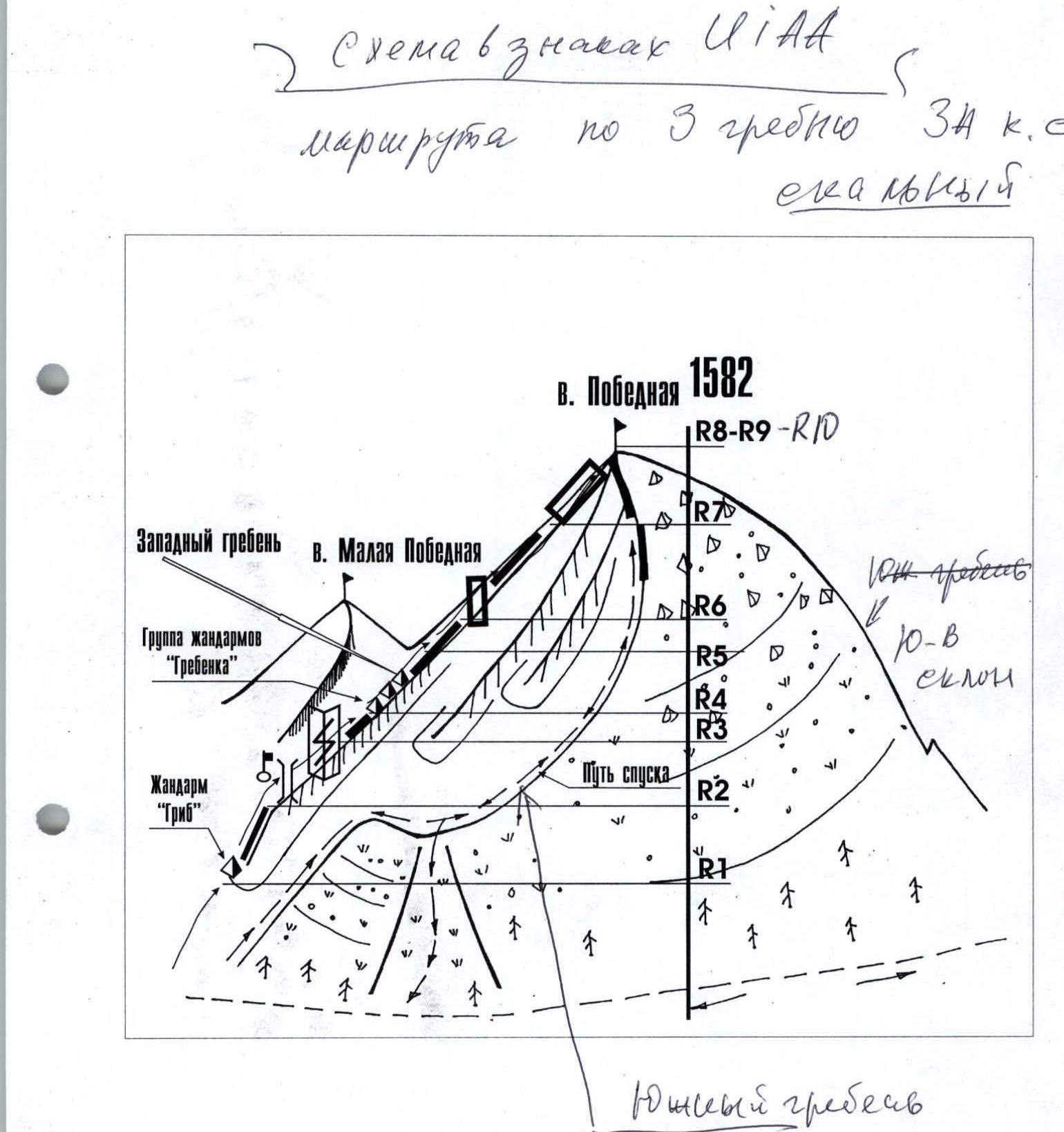
Route to the peak Pobednaya (1582) via the South Ridge 1B complexity category. Rocky.
Ascent scheme in UIAA signs:
R0–R1 — approach to the base of the south ridge. (Trail. 2.5 hours, non-category) R1–R2 — ascent to a nameless golets. (Scree, kurumniks. 3 hours, non-category 1) R2–R3 — approach under the scree, rocky ridge. (Scree. Simple rocks. 2 hours, 600 m, 1) R3–R4 — ascent along the ridge to the subpeak. (Heavily destroyed rocks. 1.5 hours, 500 m, 1) R4–R5 — traverse of the ridge to the summit (Rocky ridge. 1 hour, 100 m, 1) R5 – summit Pobednaya. R5–R0 – descent via the ascent route.
Description of the peak – object of sports ascents
The peak 1582 (Pobednaya) is located in the highest part of the Subpolar Urals, in the Research Ridge, in the mountain horseshoe of Oleny stream, which flows into the Manaraga River. It is a well-defined rocky peak of alpine type. There is no name on the map. The local name Pobednaya is associated with:
- "in honor of the 45th anniversary of Victory in the Great Patriotic War"
- "the fact that a group of tourists from the city of Inta ascended this peak via the south ridge"
The peak is interesting for climbers primarily due to its rocky ridges and counterforts from the west, the north ridge, as well as the eastern wall, which can be confidently attributed to the challenging rocky routes of the Subpolar Urals.
The ascent via the south ridge was made by a sports group of climbers from the monitoring expedition "Pobeda – 2005" in July 2005.
Accomplished by:
- Sports group of climbers from Syktyvkar and Yoshkar-Ola (leader M. Popov +2)
- Training department NP-1 (Zhuravlev +10)
Description of the route – object of sports passage
Approaches to the area of ascents ("PSP 'Manaraga'. Mountain horseshoe of Oleny stream"): From the Zhelannaya geologists' base, through the Karkar pass, or the Limbeiko and Zigzag passes, cross over to the Manaraga River valley and approach the Oleny shelter. This is a cabin located near the mouth of Oleny stream, which flows into the Manaraga River. The transition takes two travel days.
Approach to the start of the route (OSV): From Oleny shelter, follow a well-trodden geological and tourist trail to the crossing over Oleny stream. (Ford crossing). Then, follow the trail to the base of the south ridge and ascend via the "kurumniks" to the goltsy zone. Then, ascend via the scree slopes to the summit of a nameless goltsy of the south ridge. Further along the ridge, transitioning from scree to rocky, heavily destroyed, consisting of large stone blocks. (Until June 25 – snowy section). Then along the ridge, via rocks of 1-2 complexity category, reach the southern subpeak, formed by the confluence of two counterforts of the western slope. From the subpeak to the main summit of Pobednaya, there are about 100 meters of traversing a simple rocky ridge with a slight gain in height.
The total ascent time for the NP-1 department is within – 8-9 hours. The route is interesting not only for conducting training and sports ascents NP-1, 2, but also for mass alpine events for youth in the summer.
Descent. The safest – via the ascent route. In summer, a variant of descent via the "green couloir" along the stream bed, originating from the saddle separating the nameless goltsy and peak Pobednaya, towards the Manaraga River valley, is possible. In summer, during rain, descent via the second variant is complicated by steep grassy slopes. In winter, this descent option is not recommended – avalanche hazard.
Required equipment (calculation made for a sports group of разрядников from four people): main rope – 2×40, carabiners – 3, rocky pitons – 3, station loops – 2. Primus stove – 1, pot – 1.
Overview photo of the ascents area taken from the step leading to the Zigzag pass, from east to west.
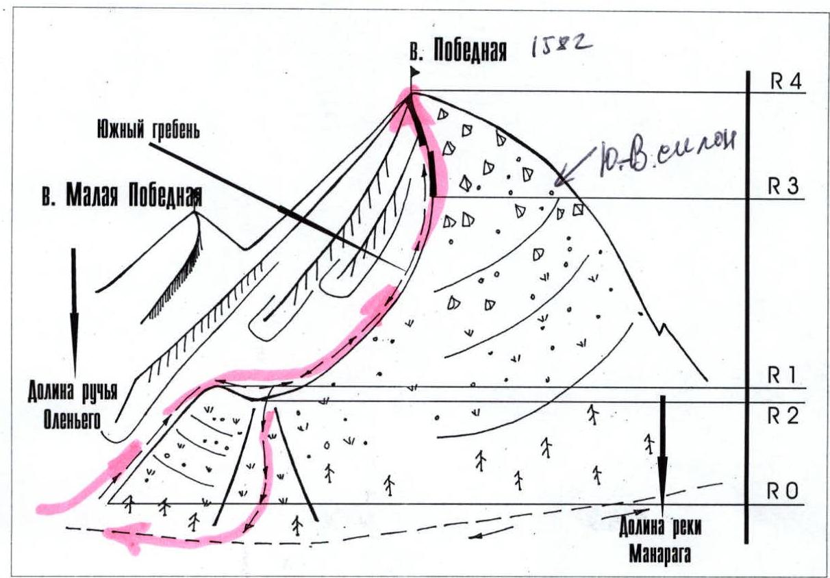
Profile of the south ridge of peak Pobednaya (1582)
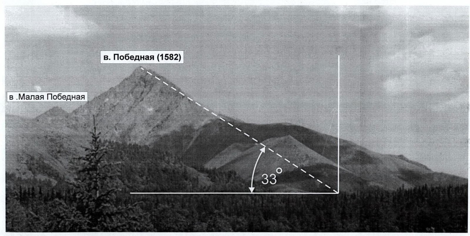
The route to peak Pobednaya via the south ridge 1B complexity category consists of two parts:
- Gentle exit under the rocky ridge (about 25°)
- steeper rocky section (45°, and on some sections – 55°)
The profile photo was taken from Oleny shelter, from the west.