Ascent Passport
- Region, gorge, section number according to the classification table (2001) – 11.3 Mountain region of Kunlun (China, Xinjiang Uyghur Autonomous Region), Muztagata massif, Kalakhong glacier.
- Name of the peak: Peak Koskulak, 7028 m, route name: via SW ridge.
- Category of difficulty: 5A category, approximately; first ascent
- Nature of the route — snow-ice
- Height difference of the route: 2100 m (according to map, altimeter, and GPS); route length – 6025 m; length of sections with 5th category of difficulty – 210 m; 6th category of difficulty – 0. Average steepness: of the entire route 21°, of the section 6300–6400 – 41°.
- Pitons used on the route: rock – none, ice – 3, chocks – none, snow – 2.
- Number of climbing hours to the summit – 30.5 hours, total – 37.0 hours, days – 4.
- Number of bivouacs and their characteristics: total 3 bivouacs, all in tents, including 1 at 5700 m, 1 at 6300 m, 1 at 6500 m.
- Group leader: Petrov Andrey Evgenievich, Candidate Master of Sports, born 1948. Group members: Odokhovsky Vyacheslav Veniaminovich, Candidate Master of Sports
- Leader of the MAI sports club expedition: Volkov Mikhail Evgenievich, Candidate Master of Sports Group coach: Khokhlov Yuri Vladimirovich, Master of Sports. Senior coach: Tinin Yuri Pavlovich, Candidate Master of Sports Departure onto the route: 10:00, August 16, 2005. Summit: 15:00, August 19, 2005. Return to base camp: 21:30, August 19, 2005. Beijing time
- Organization – Moscow Federation of Mountaineering and Rock Climbing

General Photo of the Summit
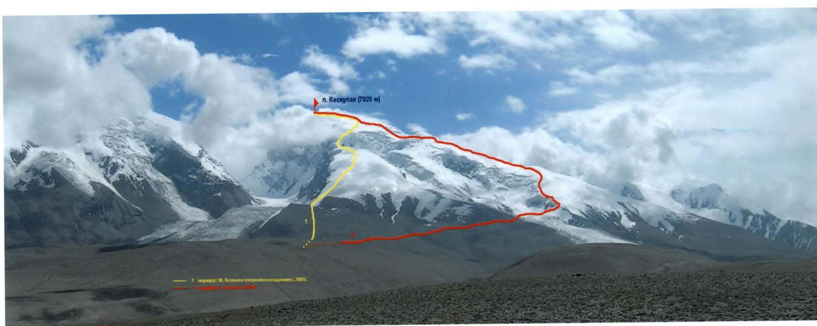 Photo № 1 (A. Petrov), August 20, 2005, from the slope above the pass
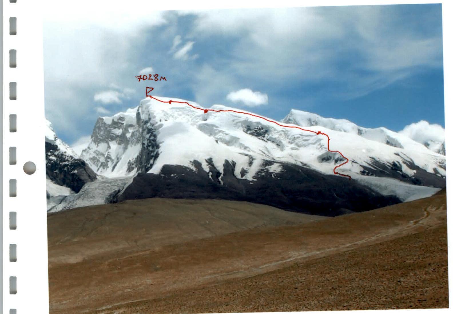 Photo № 2 (V. Odokhovsky) from an altitude of 4600 m, August 2005
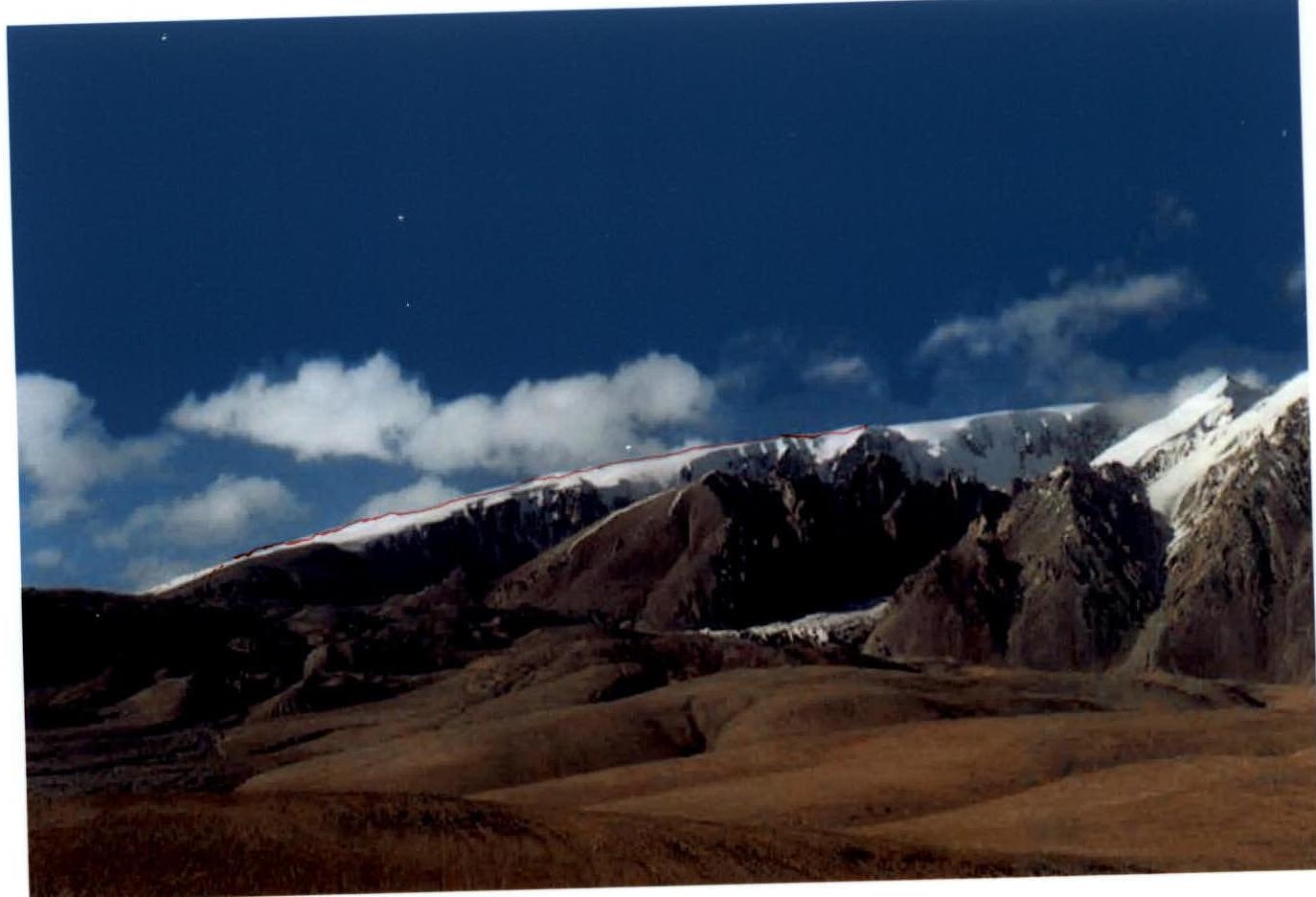 Photo № 3 (A. Lebedev) from the slope at an altitude of 4200 m, August 2003
 Photo № 4 (A. Ershova) from the slope, at an altitude of 4000 m, 2003
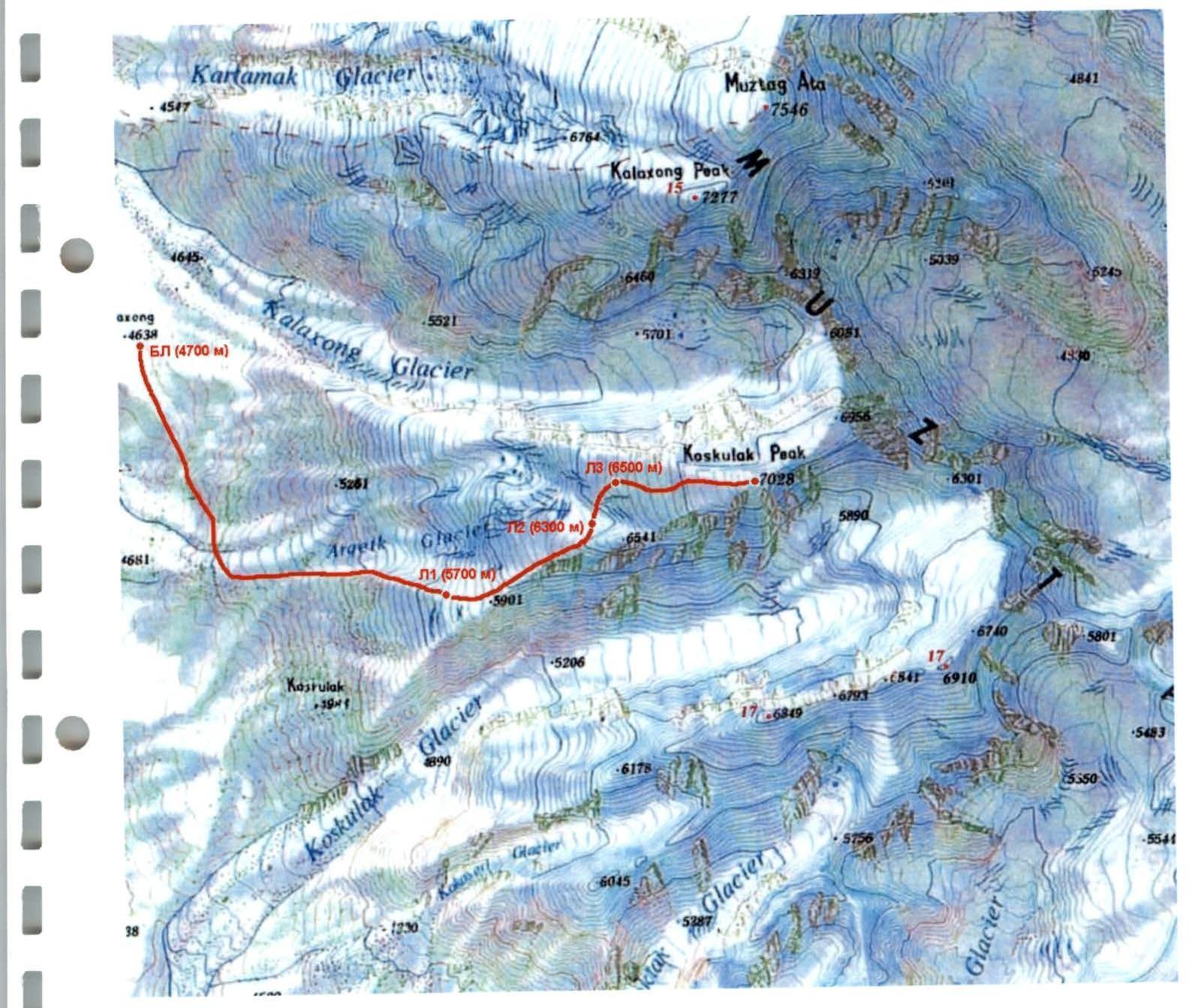
Schematic Diagram of the Ascent Object with the Route
Brief Overview of the Ascent Region
Peak Koskulak, 7028 m is located in China, in the Muztag Ata massif, between the peaks Muztag Ata (7546 m) to the north and Peak 6849 m to the south.
The eastern edge of the Pamir Plateau is bordered by a chain of high mountain ridges. They rise like a huge wall above the oases of Kashgar and the Taklamakan Desert. This chain begins from the eastern outskirts of the Trans-Alai range and, turning to the southeast, turns into the King-Tau ridge with the highest mountain Chakragil 6670 (some maps show the name Karabektortag). The Kashgar ridge is separated from the King-Tau mountains by the Gezdarya valley. The upper reaches of Tashkurgandarya separate the Kashgar ridge from the Tashkurgan and Chon-Kyr ridges to the east, which continue this mountain chain until it connects with the Western Kunlun.
The highest points of the Kashgar ridge, the peaks Muztag Ata (7546) and Kongur Tag (7719), lie at the intersection of the axial lines of many ridges. They are referred to as both the Eastern Pamir and the Western Kunlun. The total glaciation area of the ridge is 2258 km². On Kongur and Muztag Ata, there are dozens of glaciers, with the largest reaching 15 km.
The foothills to the west and southwest are located at altitudes of 3800–4000 m, the slopes have fairly gentle outlines, although they are quite steep. The tongues of the glaciers are located at altitudes of around 4500 m. The valleys to the east are more deeply incised than to the west, and the rivers flow through canyons in some places. On the northern slopes of the ridges, forests of fir, juniper, and Tian-Shan spruce are preserved in some places. The main population of the Kashgar mountains consists of Kyrgyz people. To the east and northeast, the Muztag Ata massif is bordered by 2–3-kilometer-high rock-ice walls. To the west, the entire massif is cut through by a system of cirques with kilometer-high walls. Muztag Ata is a popular object for mountaineers, but Peak Koskulak had not been climbed before.
The journey from the city of Kashgar (1300 m), Xinjiang Uyghur Autonomous Region, China, takes 4–5 hours to Lake Karakul (3600 m). The road in the area of the lake is being improved, and delays are possible. There is a tourist base at the lake, with yurts available for overnight stays. Then along the highway for 20–23 km. To the base camp (BC) for the ascent to Koskulak, there are two possible routes from here. The first is to turn left 2–3 km before the pass, then with a caravan of donkeys for 4–5 hours. The second is to turn left from the pass onto jeeps to the lake, from where it takes 1 hour to BC. BC (4700 m) is located on grass, with a stream nearby.
The approach to the start of the route along the SW slope from BC is done by traversing south along the talus, which at an altitude of 5100 m turns into snow-ice slopes. The exit is onto a glacier cut by ice rivers with steep walls. The first river is crossed via a snow bridge, and then along a steep snow-ice slope. Then left and up along the glacier under the ridge for 500 m. Overcoming crevasses to the right and then ascending up a steep, up to 55°, snow slope (with protection for 100 m) to a gentle part of the snow ridge. The path along the glacier is the beginning of the route. From BC, the length of the approach is 3 km (according to the map, 1 cm = 1 km).
Ascent Schedule and Weather Conditions
Altitude, m
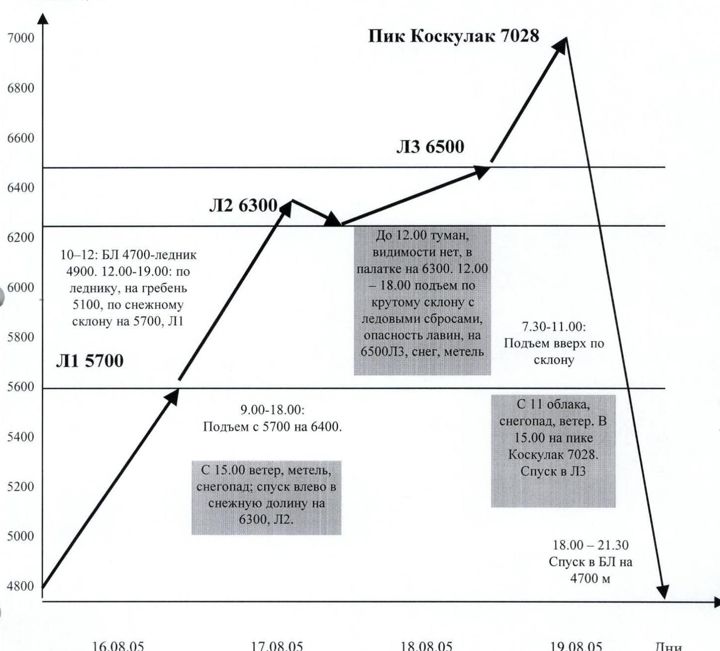 ■ – bad weather (snowfall, wind)
BC – base camp
C1 – Camp 1, ..., C3 – Camp 3
■ – bad weather (snowfall, wind)
BC – base camp
C1 – Camp 1, ..., C3 – Camp 3
Altitudes were determined and compared using an altimeter with a scale up to 9000 m, altimeters in watches, and the GPS system.
Route Diagram in UIAA Symbols
| Pitons | Description of Section | Length | Steepness | Category of Difficulty | Section № |
|---|---|---|---|---|---|
| Summit of Peak Koskulak, 7028 m, August 19, 2005, 15:00 | 200 | 10 | 1 | R16 | |
| Snow dome | 500 | 20 | 2+ | R15 | |
| 300 | 15 | 2 | R14 | ||
| August 18, 2005. C3 6500 m, on the slope under ice falls. Total | 810 m | Height difference 200 m, 5 hours | |||
| Snow slope | 500 | 15 | 2+ | R13 | |
| Deep snow, track-making | 100 | 15 | 3+ | R12 | |
| 1 | 10 | 60 | 5 | R11 | |
| 1 | 200 | 40 | 5- | R10 | |
| August 17, 2005. C2 6300, snow valley. Total | 2100 m | Height difference 600 m, 9 hours | |||
| Below snow-ice slope | 300 | 0 | 1 | R9 | |
| Descent from the ridge into the valley | 800 | 20 | 2+ | R8 | |
| Exit onto the snow ridge, deep snow | 200 | 30 | 3+ | R7 |
Route Diagram in UIAA Symbols (continued)
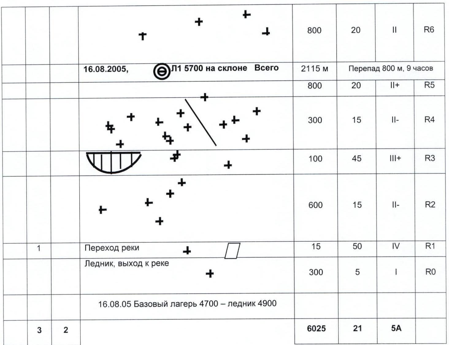
| Pitons | Description of Section | Length | Steepness | Category of Difficulty | Section № |
|---|---|---|---|---|---|
| 800 | 20 | 2 | R6 | ||
| August 16, 2005. C1 5700 m on the slope. Total | 2115 m | Height difference 800 m, 9 hours | |||
| 800 | 20 | 2+ | R5 | ||
| 300 | 15 | 2- | R4 | ||
| 100 | 45 | 3+ | R3 | ||
| 600 | 15 | 2- | R2 | ||
| 1 | River crossing | 15 | 50 | 4 | R1 |
| Glacier, exit to the river | 300 | 5 | 1 | R0 | |
| August 16, 2005. Base camp 4700 – glacier 4900 | 6025 | 21 | 5A |
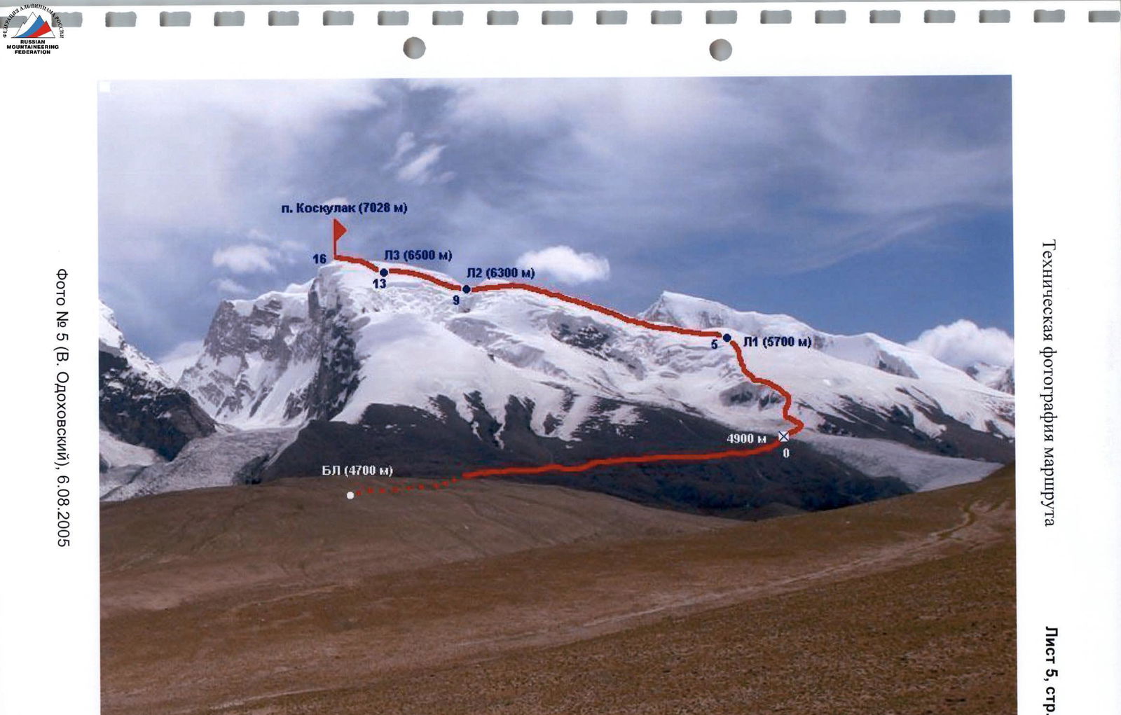
Photo № 5 (V. Odokhovsky), August 6, 2005. Notes from control points and the summit. Due to the fact that the summit is a gentle snow dome without rock outcrops, there is no note from the control point on the summit of Peak Koskulak, 7028 m, as there is no control point itself.
At the same time, A. Petrov on August 12, 2005, made an ascent to Peak Koskulak, 7028 m via the northwest ridge as part of a group of MAI mountaineers led by Mikhail Volkov. This was the first ascent to this peak. A bamboo pole with a red flag was left on the summit.
Now our group added three more bamboo poles with a note about the ascent to Peak Koskulak, 7028 m via a new route along the southwest ridge.
Thus, our group's ascent to Peak Koskulak is the first passage of this route.
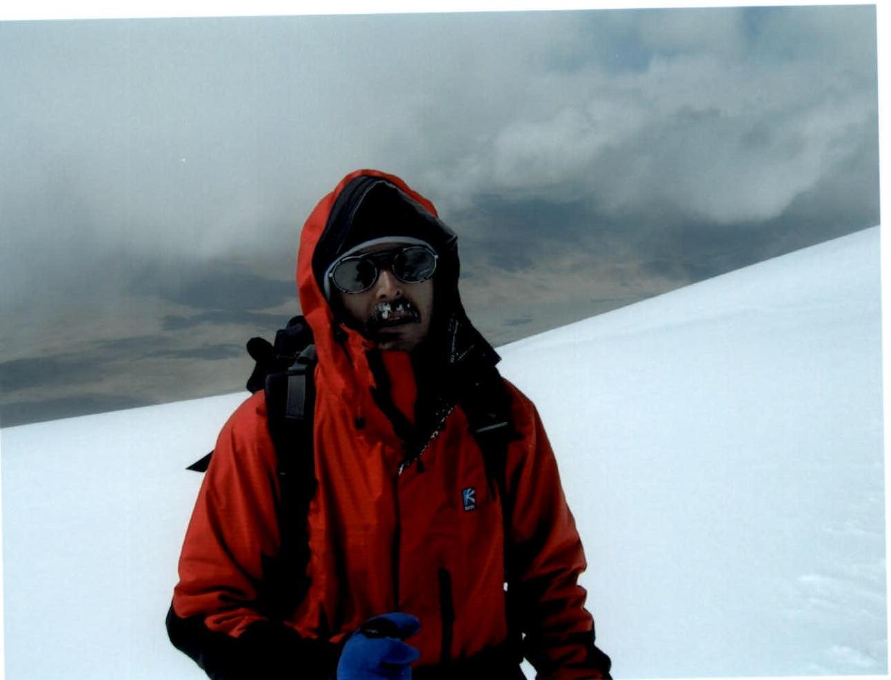 Photo № 6 (A. Petrov). V. Odokhovsky on the summit of Peak Koskulak, 7028 m, August 19, 2005, 15:00. There is no note here. There are no rocks for a control point either.