FEDERATION OF ALPINISM AND ROCK CLIMBING OF UKRAINE
World Championship in Alpinism Technical Class
Report
On the ascent of the Ukraine-2 team (FAR Kharkiv region) to Peak Iskander 5120 m
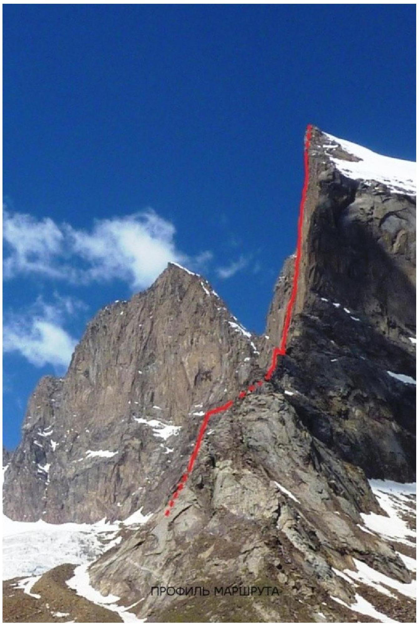
Via the South Face. Zhiltsov's route VI–A cat. sl. rock. Third ascent.
Poltavets E. I. — team leader Timko E. N.
Kharkiv 2013
Participants of the ascent
- Team leader — Poltavets Evgeniy Ivanovich. MS. Coaches — Sukhareva L. N., Kopeyka G. V. Address: 61144, Kharkiv, Akademika Pavlova st., 162A, apt. 118. Tel. +38095-125-33-40. Email poltalp@ukr.net
- Timko Evgeniy Nikolaevich. CMS. Kharkiv.
Coaches:
- Sukhareva L. N.
- Kopeyka G. V.
Ascent Passport
- Pamir-Alay. Turkestan Range. Laylyak gorge area, section 5.4.2 of the 2008 route classifier for mountain peaks
- Peak Iskander via the South Face. Zhiltsov's route
- 6A cat. sl. Third ascent.
- Rock route.
- Height difference: 920 m (by altimeter)
Route length: 1270 m. Length of sections with V cat. sl.: 270 m Length of sections with VI cat. sl.: 360 m
- Average slope of the route — 67
degrees. Main part of the route — 84 degrees
- Equipment used on the route:
rock pitons (and chocks) — 447, ice screws — 0, stationary pitons (previously hammered) — 2 (Golubev's stopper), including for artificial aids — 0, total artificial anchors used — 189. Pitons left on the route: total — 15 (on descent); including bolting — 0
- Team's total climbing hours: 48.5 h, 5 days.
- Descent from the summit via the ascent route (6A cat. sl.)
- Team leader: Poltavets Evgeniy Ivanovich, MS, coaches Sukhareva L. N., Kopeyka G. V. Participant: Timko Evgeniy Nikolaevich, CMS, coaches Sukhareva L. N., Kopeyka G. V.
- Start of the route: 10:00, July 11, 2013
Summit: 6:30, July 16, 2013. Return to base camp: 21:00, July 16, 2013
-
Federation of Alpinism and Rock Climbing of Kharkiv region.
-
Responsible for the report — Poltavets E. I. poltalp@ukr.net
ASCENT AREA DESCRIPTION
Peak Iskander — 5120 m, is located in the Turkestan Range. It is situated in the upper reaches of the AkSu river, 30 km west of the Match) node.
The AkSu river, merging with the KaraSu river, forms the Jetykuirik river, which flows into the Laylyak river. 30 km downstream from the confluence of the Jetykuirik and Laylyak rivers there are settlements:
- Katran
- Uzguurush
They can be reached by car. Further, there is no road to the base camp, located at an altitude of 2900 m — pack animals are needed. From the village Uzguurush to the base camp it takes about 6–7 hours.
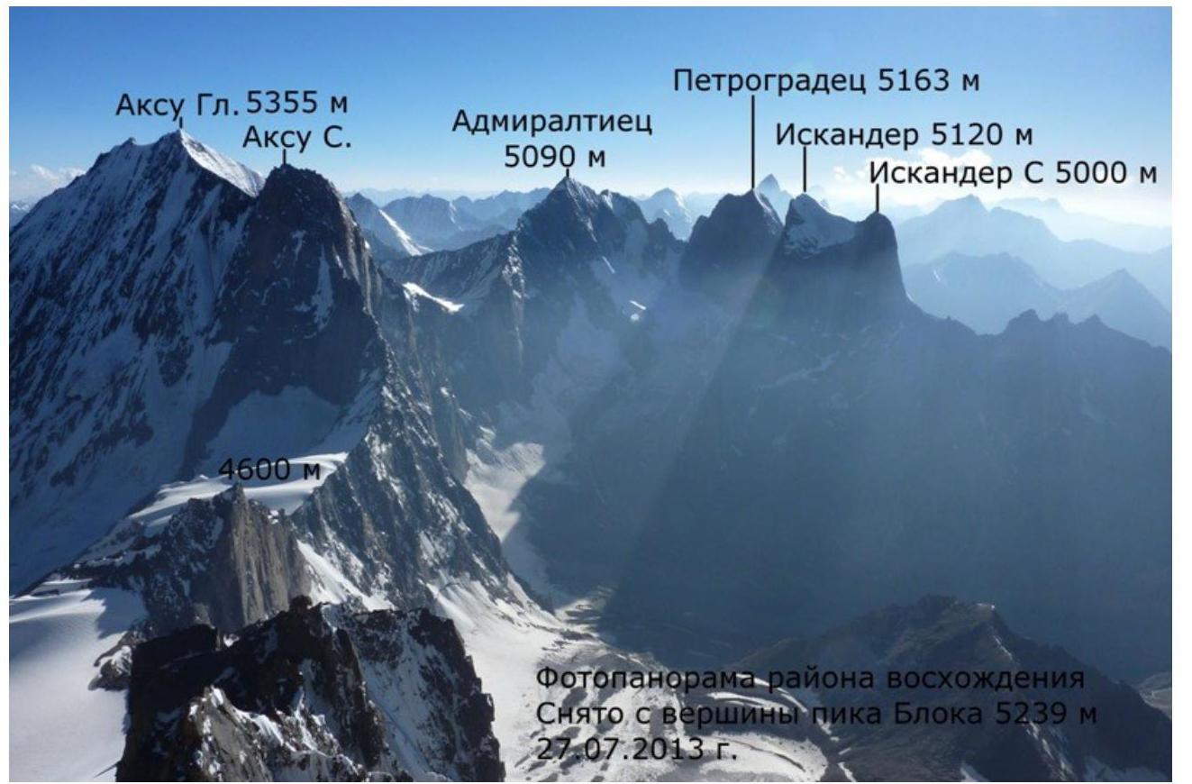
The area is fairly well освоен by climbers thanks to an impressive set of technically complex peaks and routes. In the gorge, there are several five-thousanders:
- Peak Bлока
- AkSu
- Admiralteets
- Petrogradets
- Iskander
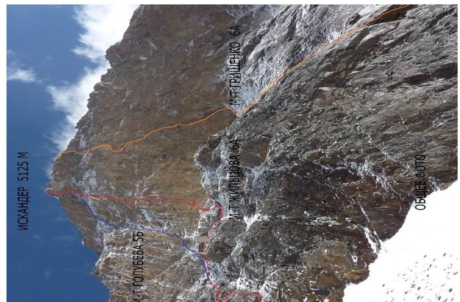
The relief character of these peaks is distinguished by large steepness and smoothness. On the South face of Iskander, 3 routes are laid:
- Golubeva 5B
- Zhiltsova 6A
- Grischenko 6A
All of them are characterized by a large steepness (about 85 %) of the main wall and smooth relief.
The peaks of the watershed range are composed mainly of large-block, little-dissected granites.
The northern spurs are composed of:
- granite,
- limestone,
- schist.
At the contacts, there are pegmatite outcrops.
 iPOGUJIL
NAPUJFYTA Peak Iskander 5120 m. Profile of the route 1:3000
iPOGUJIL
NAPUJFYTA Peak Iskander 5120 m. Profile of the route 1:3000
| 16.07.13 5120 | R29 | |
|---|---|---|
| 15.07.13 5090 | R28 | |
| M | R27 | |
| R26 | ||
| R25 | ||
| R24 | ||
| R23 | ||
| 13-14.07.13 4850 | R22 | |
| M | R21 | |
| R20 | ||
| R19 | ||
| R18 | ||
| R17 | ||
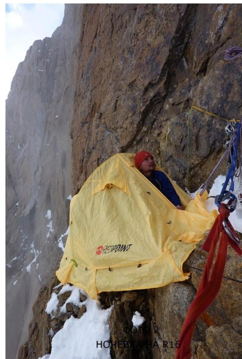
| 12.07.13 4650 | R16 | |
| M | R15 | |
| R14 | ||
| R13 | ||
| R12 | ||
| R11 | ||
| 11.07.13 4450 | R10 | |
| 1 | M | R9 |
| 84 | R8 |
- R7
- R6
- R5
- R4
- R3
- R2
- R1
- 4200 м
- R0
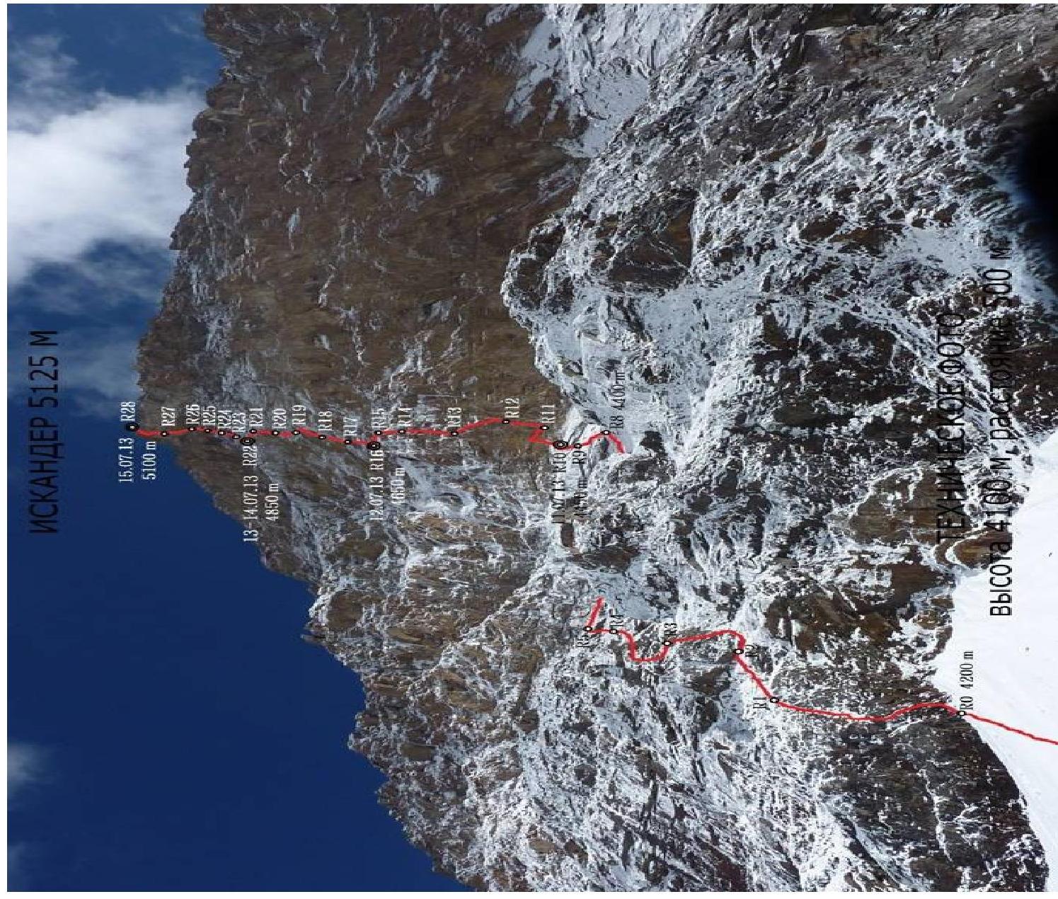
HOLA-YEER 5125 м
1. 1. 1. 1. 1. 1. 1. 1. 1. 1. 1. 1. 1. 1. 1. 1. 1. 1. 1. 1. 1. 1. 1. 1. 1. 1. 1. 1. 1. 1. 1. 1. 1. 1. 1. 1. 1. 1. 1. 1. 1. 1. 1. 1. 1. 1. 1. 1. 1. 1. 1. 1. 1. 1. 1. 1. 1. 1. 1. 1. 1. 1. 1. 1. 1. 1. 1
| R9–R10 | 6 | — | — | — | | 15 | |
| 10 | 80 20 | — V I | |||||
|---|---|---|---|---|---|---|---|
| R8–R9 | 17 | - | - | 3 | 40 | 75 | |
| R7–R8 | 16 | - | - | - | 80 | 50 | |
| R6–R7 | 4 | - | - | 100 | 40 | ||
| R5–R6 | 4 | - | - | - | 15 | ||
| 30 | 60 45 | IV II | |||||
| R4–R5 | 15 | - | - | 7 | 15 | ||
| 35 | 80 70 | 6Б 2А |
3 IV | | R3–R4 | 10 | - | - | 6 | | 20 20 | 45 80 | II VIA1 | | R2–R3 | 11 | - | - | - | | 45 | 70 | IV | | R1–R2 | 6 | - | - | - | | 40 | 55 | III | | R0–R1 | 12 | - | - | - | | 45 | 70 | IV |
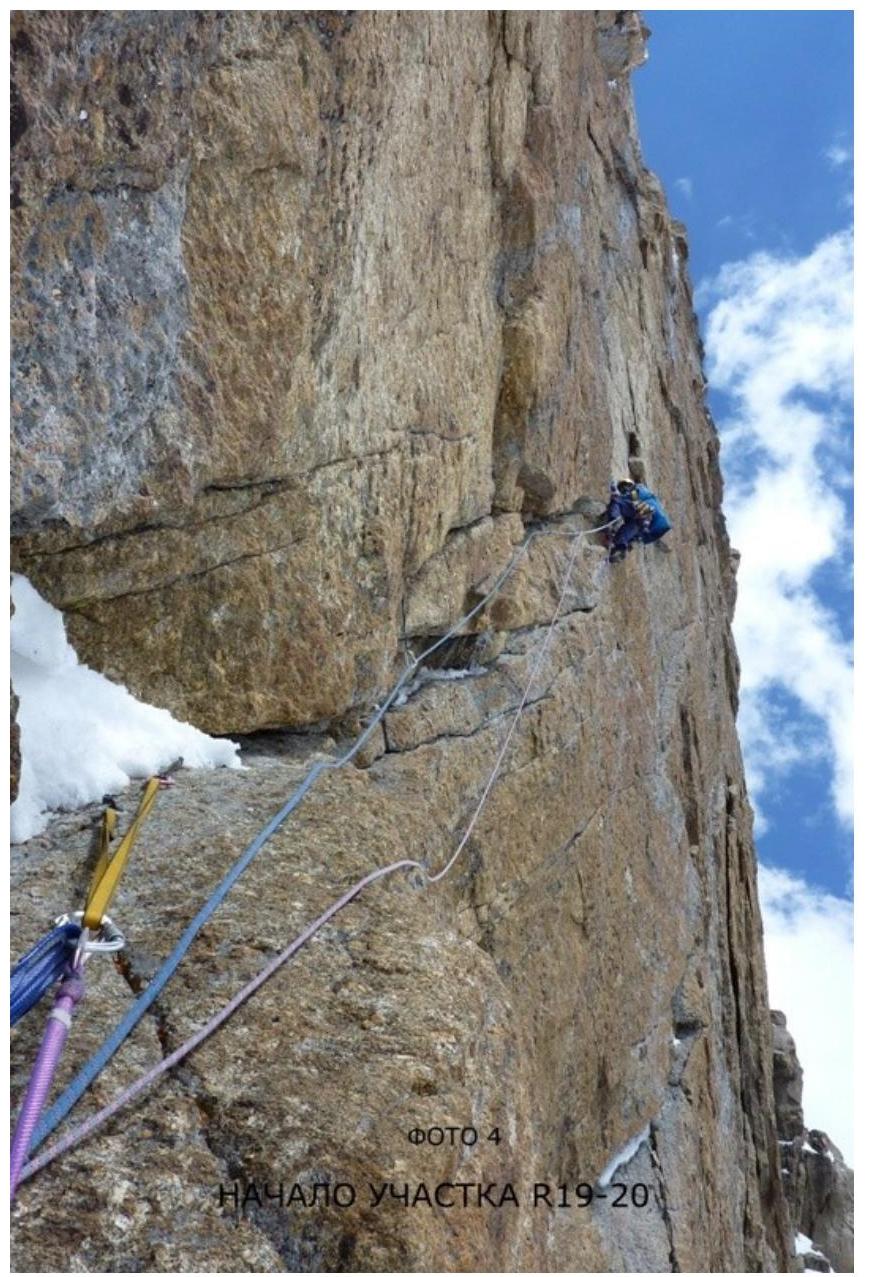
| R19–R20 | 18 | - | - | 10 | фото 4 | 10 10 10 | 85 85 85 | VIA1 VIA2 V | |
|---|---|---|---|---|---|---|---|---|---|
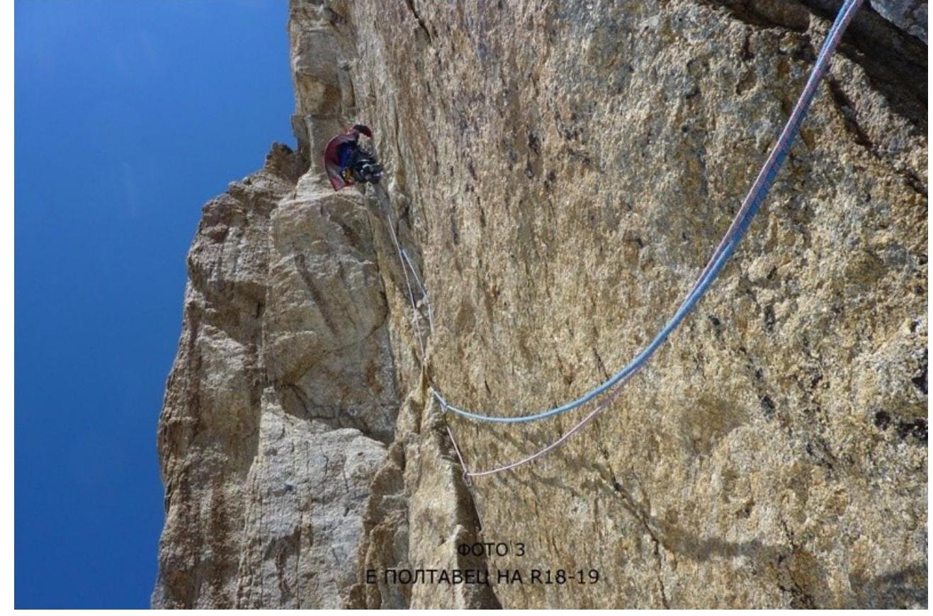
| R18–R19 | 30 | - | - | 27 | фото 3 | 5 20 5 10 | 85 85 85 85 | VIA2 A3+ A2 V | |
| R17–R18 | 16 | - | - | 2 | 25 | 90 | VIA1 | ||
| R16–R17 | 17 | - | - | - | 30 10 | 80 90 | V VI | ||
| R15–R16 | 4 | - | - | - | фото 2 | 15 | 50 | III | |
| R14–R15 | 24 | - | - | 8 | 30 | 90 | VIA2 | ||
| R13–R14 | 19 | - | - | - | 30 | 85 | V | ||
| R12–R13 | 22 | - | - | 10 | 3 10 15 | 90 85 80 | A2 VIA2 V | ||
| R11–R12 | 32 | - | - | 29 | 30 | 90– 95 | A2 | ||
| R10–R11 | 28 | - | - | 25 | фото 1 | 10 20 10 | 80 90 85 | IV A2 VIA2 | |
| Peak Iskander 5120 m via the South Face, Zhiltsov's route 6A cat. sl. third ascent | |||||||||
| :--: | :--: | :--: | :--: | :--: | :--: | :--: | :--: | :--: | |
| R28–R29 | - | - | - | фото 8 | 1 0 5 0 1 0 5 0 2 0 3 0 | 60 20 60 10 35 20 | III I III II II I | ||
| R27–R28 | 25 | - | - | 2 0 | 5 4 0 5 | 80 90 30 | V VIA2 I | ||
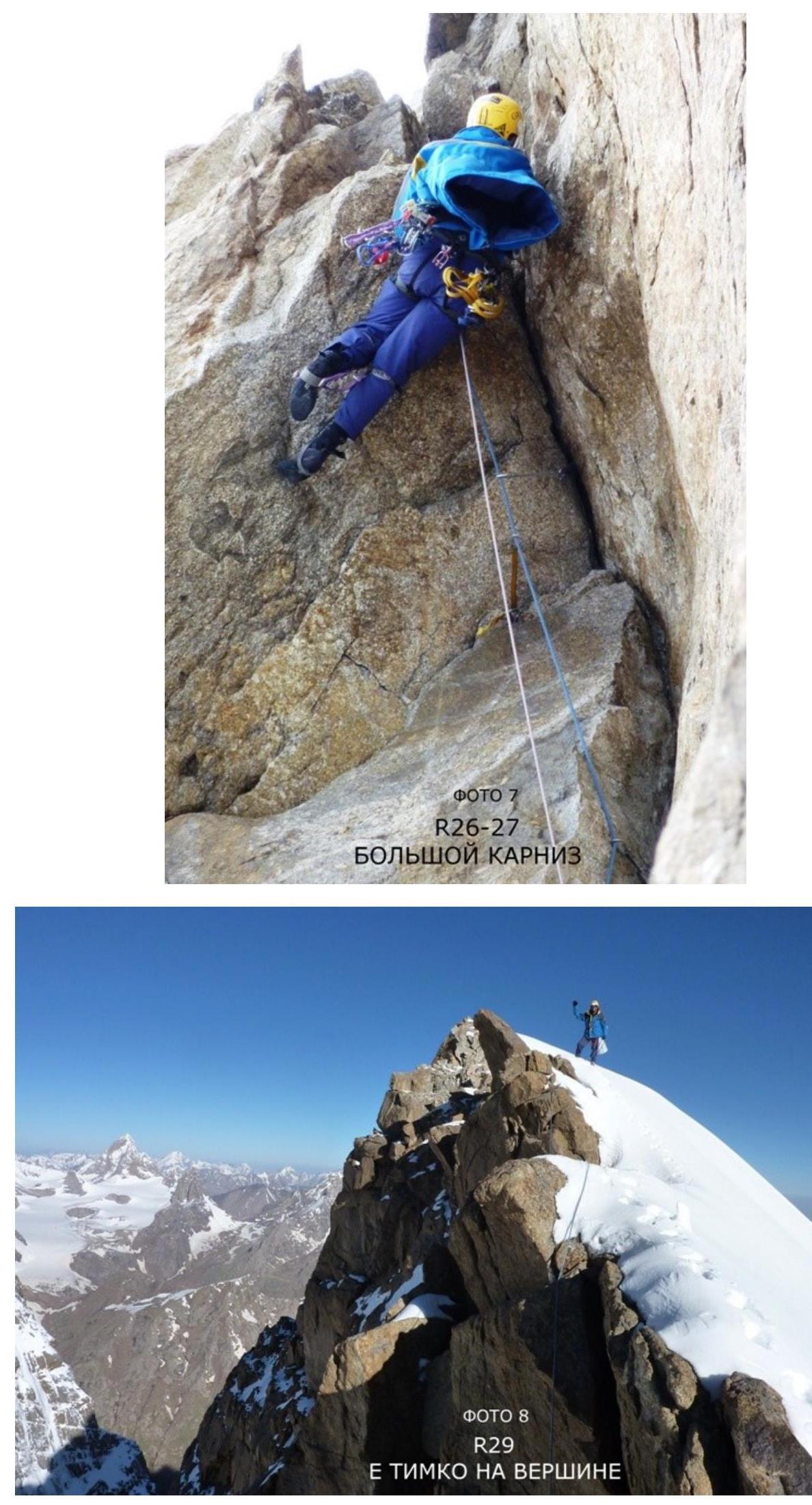
| R26–R27 | 21 | - | 2 / 0 | 1 1 | фото 7 | 5 1 0 1 5 5 | 85 80 105 80 | VIA2 V A2 V | |
| R25–R26 | 19 | - | - | 1 | 5 2 5 5 | 85 90 70 | V VIA2 IV | ||
| :--: | :--: | :--: | :--: | :--: | :--: | :--: | :--: | :--: | :--: |
| R24–R25 | 18 | - | - | 1 0 | 3 0 | 85 | VIA2 | ||
| R23–R24 | 17 | - | - | - | 4 5 | 80 | V | ||
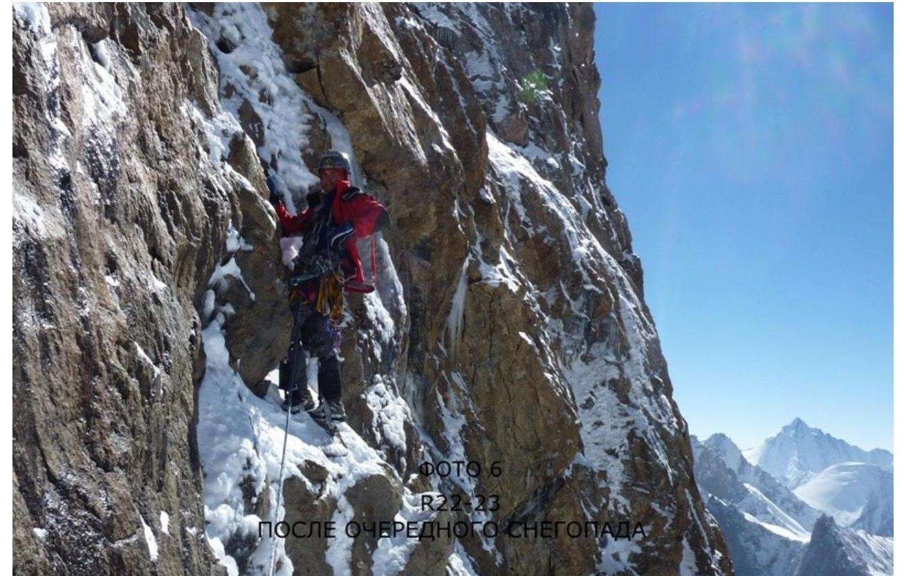
| R22–R23 | 16 | - | - | - | фото 6 | 4 5 | 75 | V | |
| R21–R22 | 3 | - | - | - | фото 5 | 1 5 | 45 | III | |
| R20–R21 | 18 | - | - | 1 0 | - | 5 2 0 | 85 85 | V VIA2 |
Route description by sections
R0–R1. To the left and below the talus peak, start moving along the walls, then along the corner. Exit to the flattening.
45 m IV R1–R2. Along the gentle rocks under the canopy. It protects from falling stones.
40 m III R2–R3. To the right towards the stream (stones are falling along the stream). To the left of the stream, along the walls, exit to the gentle rocks.
45 m IV R3–R4. Approach the wall. Along the crack, artificial aids with submersions.
20 m II, 20 m VIA1 R4–R5. To the right along the crack, complex traverse 10 m. Exit to the gentle, smoothed rocks to the left of the stream, upwards. Station at the exit to simple rocks.
15 m VIA2–A3, 35 m IV R5–R6. Upwards, through the corner, to the gentle rocks. Along them upwards.
15 m IV, 30 m II R6–R7. Exit to the right upwards to the talus, along it to the right upwards to the rocky ridge.
100 m I R7–R8. Along the ridge to the left upwards to the base of the gentle, smoothed slab.
80 m I–III R8–R9. Along the slab to the left upwards, then upwards. Exit to the internal corner.
40 m V+ A1 R9–R10. Along the corner 3 m upwards, then to the left upwards, exit to the shelf. To the right, a convenient place for a tent.
15 m — V, 10 m I R10–R11. Along the corner 5 m to the oblique shelf. Along it to the right under the canopy, complex traverse to the right to the base of the internal corner.
10 m IV, 20 m A2, 10 m VIA2 R11–R12. Along the overhanging corner upwards, it is better to make a station before the end of the corner, as insurance is problematic further.
30 m A2 R12–R13. To the end of the corner upwards, then to the left, bypassing the overhanging wall. Along the thin crack on anchors, exit to the relief. Further, climbing to the left upwards. Station at the base of the large internal corner, there is a large ledge.
3 m А2, 10 m VI А2, 5 m А2, 15 m V R13–R14. Along the internal corner upwards.
30 m V R14–R15. Continue moving along the corner. Above, the corner turns into a chimney, there is a cork.
30 m VI А2 R15–R16. Move to the left along the shelf upwards. Here is a platform for a tent.
15 m III R16–R17. Along the wall upwards, aiming at the internal corner formed by the "nasypka". Along the corner upwards, exit to the shelf.
30 m V, 10 m VI R17–R18. Along the wall with a crack to the right upwards, further upwards. Exit to the shelf, station on the right side.
25 m VI А1 R18–R19. From the left edge of the shelf along the "rotten corner" to its end. Through the canopy — cork upwards and to the left under the next canopy with a crack. Through it upwards to the flattening. Further upwards to the shelf.
5 m VIA2, 20 m A3+, 5 m A2, 10 m V R19–R20. To the right upwards along the crack 10 meters, further to the left upwards along the system of rocks. Move to the large "White corner". Along its right wall upwards to a small shelf.
10 m VIA1, 10 m VIA2, 10 m V R20–R21. To the right to the crack, along it upwards. Movement is behind the right outer edge of the corner. Then return to the right wall of the large corner. Along it upwards to the shelf.
5 m V, 20 m VIA2 R21–R22. Move to the left to the bivouac site.
15 m III R22–R23. Upwards along the non-monolithic, snow-covered rocks.
45 m V R23–R24. Upwards, slightly to the right, in the direction of the internal corner. Along the destroyed corner — chimney upwards to the shelf.
45 m V R24–R25. To the right onto the gentle slab. Bypass the canopy from the left along the oblique crack and exit to the shelf. From the shelf to the left, pass to the artificial aid to the left of the destroyed corner and exit to the positive relief.
30 m VIA2 R25–R26. To the right into the corner. Along the corner to the right upwards, further along the destroyed wall, exit to the beginning of the huge crescent-shaped internal corner.
5 m V, 25 m VI A2, 5 m IV R26–R27. Along the internal corner upwards, overcome the large canopy and exit to the flattening.
5 m VIA2, 10 m V, 15 m A2, 5 m V R27–R28. From the left along the crack, enter the long oblique internal corner. Along the corner to the right upwards, bypassing the canopies. At the end of the corner, along the overhanging crack, exit upwards to the shelf. There is a platform for a tent.
5 m V, 40 m VIA2, 5 m I R28–R29. Along the simple rocks to the ridge. Along the simple ridge 50 m to the take-off. Overcome the take-off from the right along the rocks. Further along the simple ridge to the pass. Along the steep firn slope, exit to the flattening and further to the summit.
- 10 m III
- 50 m I
- 10 m III
- 50 m II
- 20 m II
- 30 m I
Route movement schedule
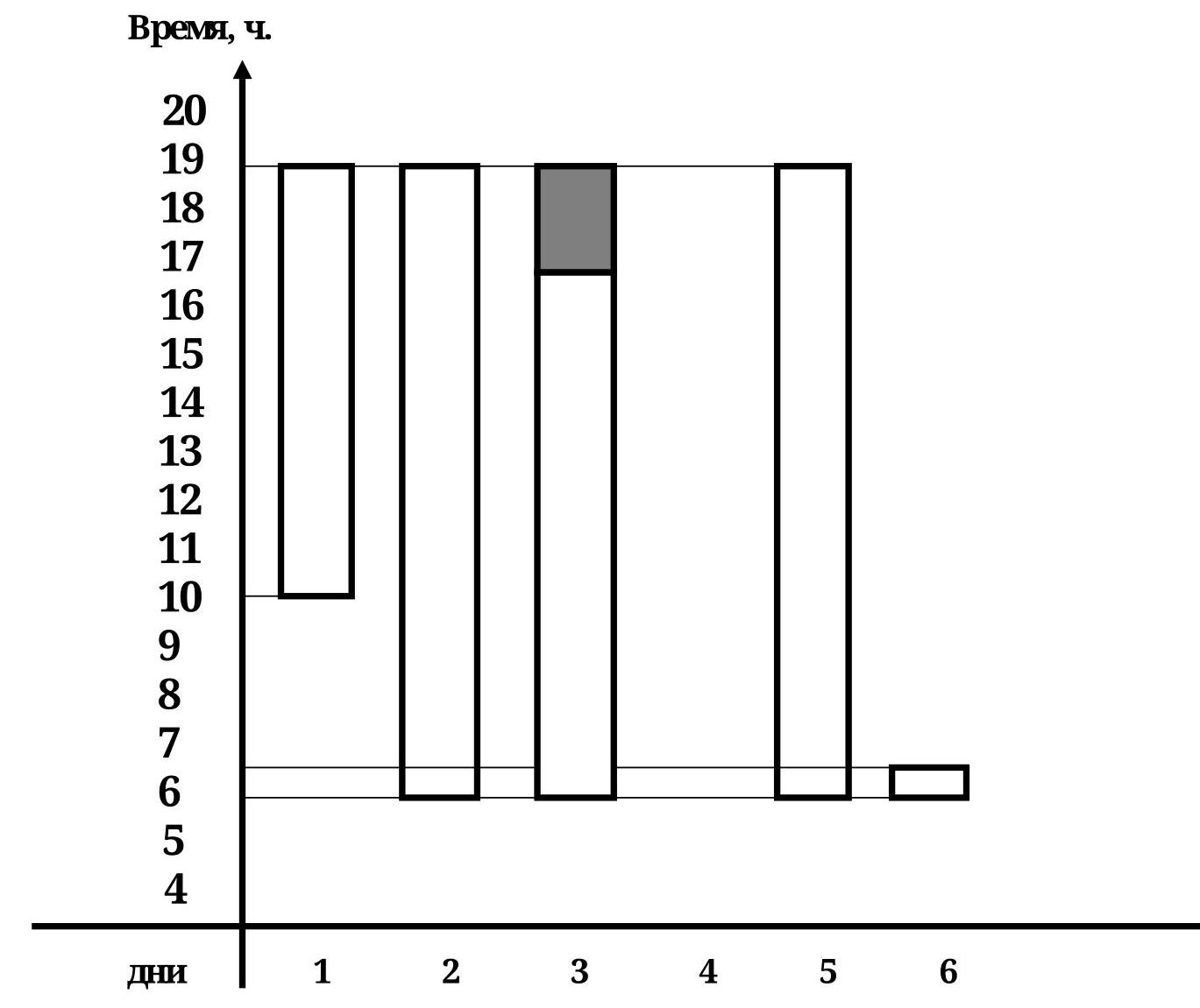
Conventional signs:
- Movement along the route
- Movement in bad weather (strong wind, snowfall)
Tactical actions of the team.
When preparing for the ascent, we studied the description made by the Moscow team (led by Ivanov), who made the second ascent of the route in 2011, as well as the report of the first ascensionists.
The approach from the base camp to the wall took 7 hours. By evening, snowfall began, continuing for two days. We had to wait out the bad weather.
We planned to complete the route in 4–5 days, but considering the complex weather conditions, we took a reserve of food and gas for 8 days.
On the first day, we started at 10:00, waiting for the rocks covered with ice crust to thaw a bit. At 19:00, we reached the shelf under the canopies and set up a bivouac.
On the second day, after climbing 6 difficult ropes, we reached the first balcony, a convenient shelf.
On the third day, again climbing 6 ropes, we set up a tent on the second balcony. We worked in snowfall for the last 2 hours. At night, a hurricane began. Until 1 am, we held the tent with our backs, fully dressed in case of its destruction.
Then the wind gradually subsided, but the snowfall continued throughout the next day, and we had to wait for the weather.
On the fourth day, we continued moving along the icy rocks and reached the summit ridge by 19:00.
On the morning of the fifth day, we ascended to the summit and descended to the camp under the wall by 17:00. After gathering our gear, we headed down and arrived at the base camp at 21:00.
The route was completed without prior processing.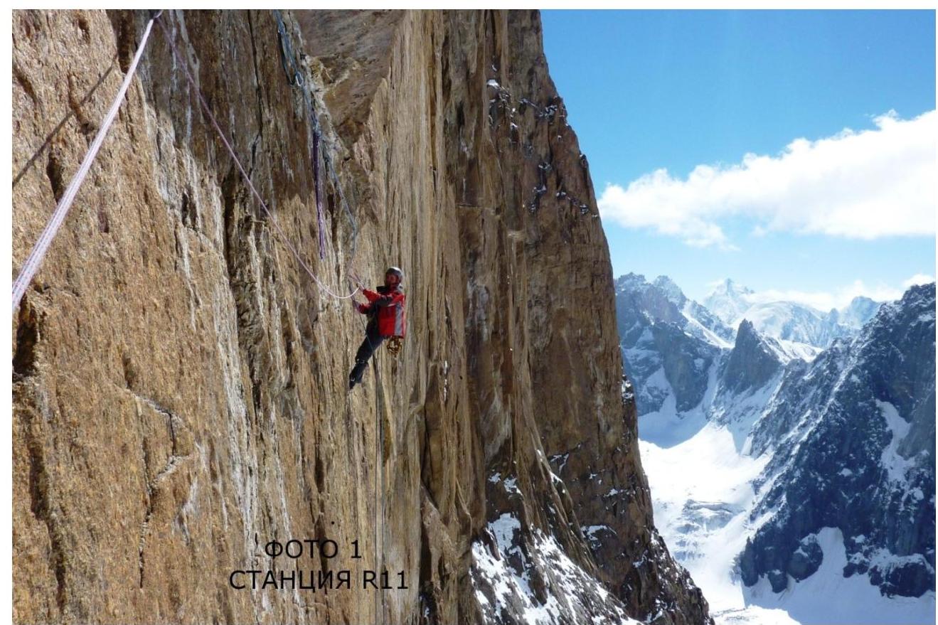
1.
Khamad Yil etka R19–R20

PHOTO 5 EXIT TO THE SHELF R2 STARTS
SNOWFALL