Ascent Passport
- Ascent class: technical (4251–5250)
- Ascent area: Turkestan Range, Aksu valley
- Peak: p. 4660 (Badygin) via North slope
- Category of complexity: 4A
- Route character: snow-ice
- Height difference — 760 m
- Average steepness — 51°
- Section length:
- R4 — 310 m
- R5 — 30 m
-
Pitons:
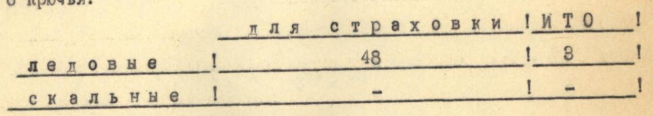
Ice: for belay — 48, for ITO — 3 Rock: for belay — 1, for ITO — 1
-
Number of climbing hours: 10
-
Number of bivouacs: 0
-
Participants: Minibaev A. A., Murtazina Z. S. — both II category
-
Coach: Khairullin Rais Shamsimukhametovich, CMS, instructor II category
-
Date of departure and return: July 9, 1984
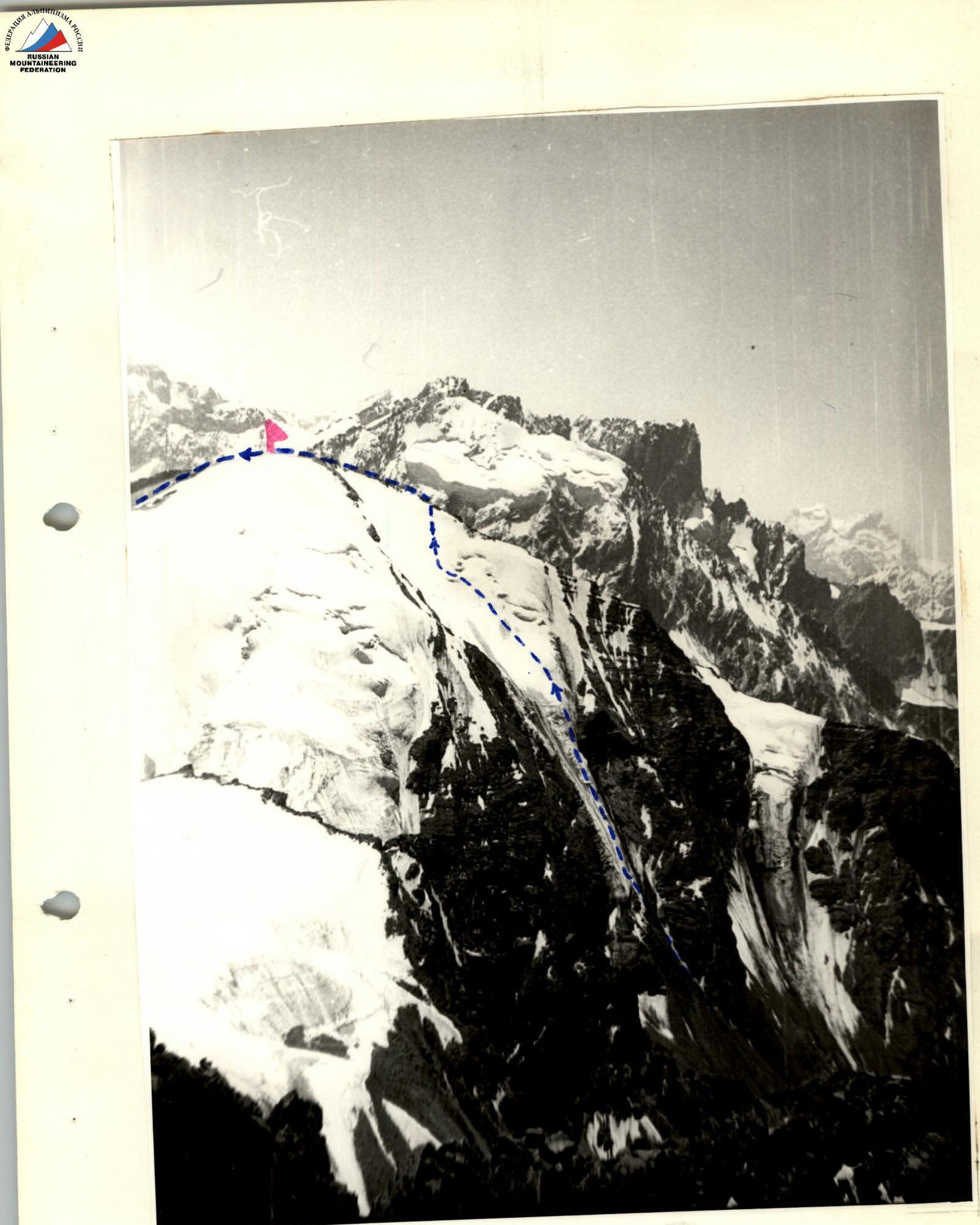
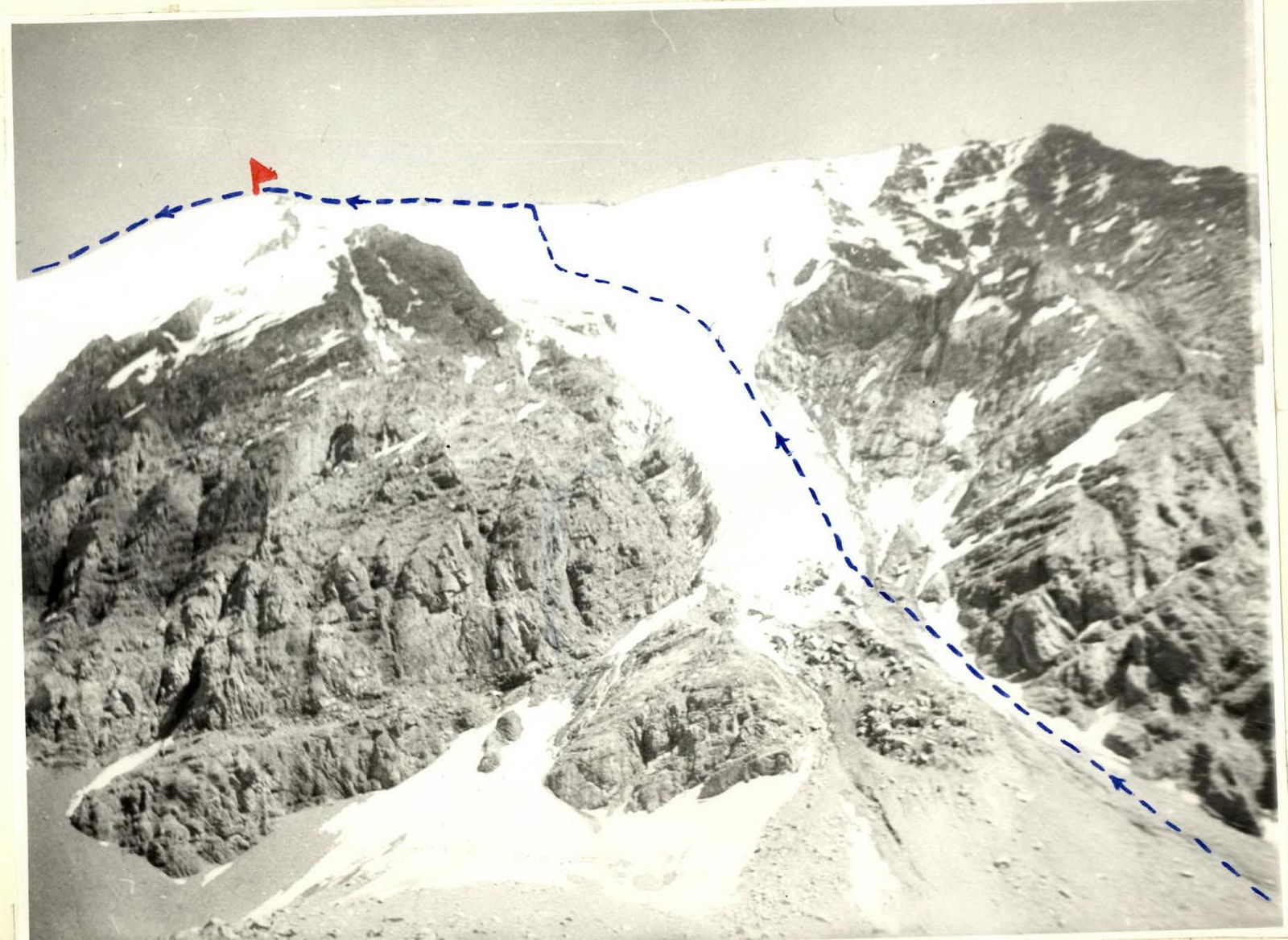 p. 4660 (Badygin). Route 4A category via N slope
 p. 4660 (Badygin). Route 4A category via N slope
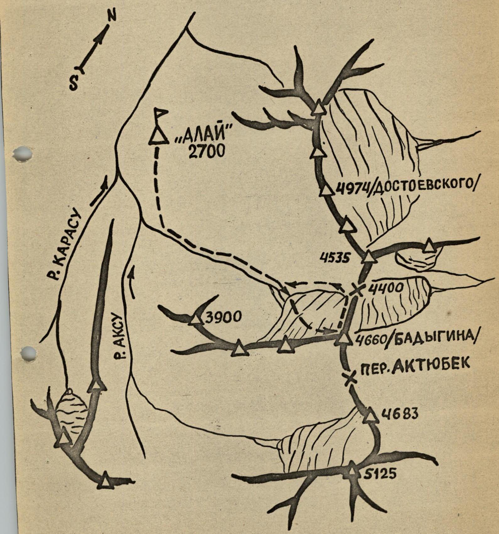
Map of the area around "Alay" tourist center
 p. 4660 (Badygin). Route 4A category via N slope
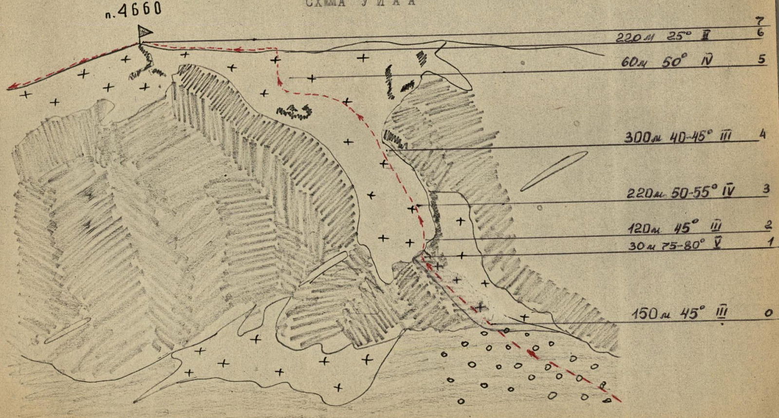
Section diagrams
Description
of the route to peak 4660 via North slope, 4A category
Peak 4660 is located in the right valley — a tributary of the Aksu River at the intersection of ridges from peak 3900 and from peaks 4974 and 5125. From the "Alay" tourist center, move along the left (in the direction of travel) side towards peak 3900, and before reaching it, turn into the Kashkasu valley. Then, a trail on the left (in the direction of travel) leads to a grassy area (Geologists' camp) — 3 hours.
The North slope of the peak is a snow-ice wall ending in rock counterforts below, between which steep ice tongues descend. The tongues are outlined by ice seracs.
From the overnight stay on the green meadow, it takes 1 hour to reach the beginning of the glacier via scree.
Overnight stays on the route are possible: if you turn onto the rocks of the central counterfort (to the very top of it) or on the simple scree ridge of the peak.
The route is logical; the steep ice tongue cannot be bypassed on either the right or left due to dangerous couloirs and "ram's foreheads" (barranies lby). It is recommended to ascend to the glacier as early as possible and avoid lingering in the lower ice couloir. After reaching the firn fields in the upper part of the route, it is necessary to move up and to the left to avoid the icefalls above, from which ice chunks may fall. The entire route, including the descent, is traversed in crampons. On steep ice sections, the use of "ice axe anchors" (ayс-фифи) is recommended, with belay using ice screws.
The descent goes from the peak to the 4400 pass via an ice-firn slope with an average steepness of 25–30°. There are cornices on the right side of this slope, so it is advisable to stay slightly below and to the left of the ridge when descending from the peak. The descent from the pass saddle goes along a scree slope, and then it is convenient to follow the right (in the direction of travel) side of the valley. The descent from the peak to the bivouac takes 2 hours.
Explanations for sections:
R0–R1 Firn slope transitioning into an ice couloir on the right, which ends in ice seracs above and "ram's foreheads" on the right; average steepness 45°. R1–R2 Ice serac bordering the glacier tongue. Steepness 75–80°. Ascended using "ice axe anchors" (айс-фифи), with ropes hung and belay using ice screws. R2–R3 Glacier tongue, average steepness 45°, ice is either exposed or has a firn crust. Move along the right part of the tongue as the left side has flows of frozen water with embedded stones and black dirt, where crampons have less grip — these flows are harder than glacier ice. R3–R4 Exposed ice, average steepness 50–55°. Convenient to ascend with an ice axe in the right hand, holding onto the slope with "ice axe anchors" (айс-фифи) in the left. Move along the right part of the tongue. R4–R5 Firn fields of the upper part of the peak, average steepness 40–45°. Ascend with alternating belay. Crampons hold well. At the top, there are icefalls that are bypassed by traversing left, then right onto a lowering in the ridge. R5–R6 Steeper ice slope leading from the firn fields to the scree gentle ridge of the peak. Steepness of exposed ice — 50°. Belay through ice screws is necessary. R6–R7 Left along the scree ridge with patches of firn to the peak. Descent along scree to the Aktubek pass, then to the bivouac to the north. Descent to the 4400 pass via a firn-ice slope with cornices on the right is desirable in crampons — steepness 25–30°.
Main characteristics of the route — peak 4660 (Badygin)
| Date | Sections | Average steepness | Length (m) | Terrain characteristics | Category | Route condition | Weather conditions | Pitons (rock/ice) | ITO | Movement type |
|---|---|---|---|---|---|---|---|---|---|---|
| July 9, 1984 | R0–R1 | 45° | 150 | Ice couloir | 3 | Ice with embedded stones | Clear, frost | 7/0 | 0 | Alternating |
| R1–R2 | 75–80° | 30 | Ice serac | 5 | Pure ice, ice screw loosens when screwed in | Frost | 6/3 | 0 | ||
| R2–R3 | 45° | 120 | Ice | 3 | Exposed ice | Frost | 6/0 | 0 | ||
| R3–R4 | 50–55° | 220 | Exposed ice | 4 | Exposed ice | Frost | 11/0 | 0 | ||
| R4–R5 | 40–45° | 300 | Firn-ice slope, snow-ice bridge across a crevasse | 3 | Thin layer of firn on ice | Frost, sun | 14/0 | 0 | ||
| R5–R6 | 50° | 60 | Ice slope | 4 | Pure ice | Sun, wind | 4/0 | 0 | ||
| R6–R7 | 25° | 220 | Scree ridge | 2 | Slate ridge | Sun, wind | 0/0 | 0 | Simultaneous |